Review of strategic noise maps in Wales - Welsh Government - October 2015 - GOV.WALES
←
→
Page content transcription
If your browser does not render page correctly, please read the page content below
Welsh Government

Review of strategic noise maps in Wales

October 2015

    Digital ISBN 978 1 4734 5020 2   © Crown Copyright 2015   WG26855
Review of strategic noise maps in Wales
1         Introduction

The Environmental Noise Directive (2002/49/EC) states that:

          Member States shall adopt the measures necessary to ensure that no later
          than 30 June 2012, and thereafter every five years, strategic noise maps
          showing the situation in the preceding calendar year have been made and,
          where relevant, approved by the competent authorities1 for all agglomerations
          and for all major roads and major railways within their territories.

Information from the strategic noise maps must be reported to the European
Commission within six months of the dates by which they are required to be made.

The Directive also states that:

          The strategic noise maps shall be reviewed, and revised if necessary, at least
          every five years after the date of their preparation.

The Welsh Government published strategic noise maps in 2012 for major roads,
major railways and agglomerations, showing the situation in 20112.

The primary purpose of this report is to review the strategic noise maps, as required
by the Directive, and determine which of them it is necessary to revise in order that
they remain sufficiently representative of the situation in 2016 to support noise action
planning and reporting to the European Commission in 2017.

The Environmental Noise (Wales) Regulations 2006 (as amended) also require the
Welsh Government to publish maps in 2016 identifying agglomerations, major roads,
major railways or major airports if it considers the most recently published maps of
them to be no longer appropriate. A secondary outcome of publishing this report may
therefore be to fulfil this regulatory requirement.

For the purposes of the Directive and the Regulations, there are no major airports in
Wales.

1
    The Welsh Ministers.
2
    http://data.wales.gov.uk/apps/noise

                                             1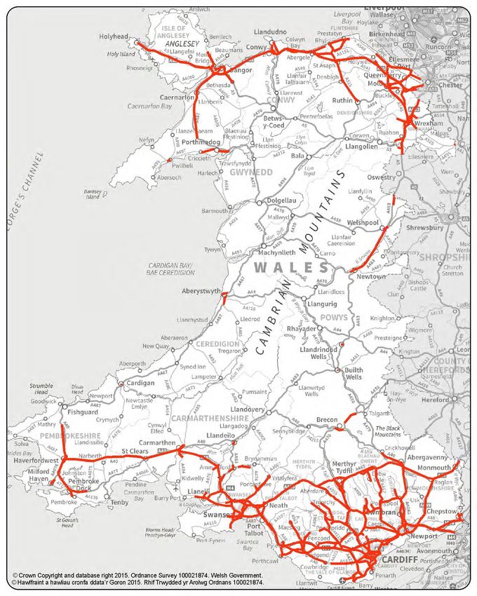
2      General considerations

One important point to consider is that the noise maps to be reported in 2017,
showing the situation in 2016, may be calculated using the same national methods
that were used in 2011/12. It is expected, however, that the noise maps to be
reported in 2022, showing the situation in 2021, will have to be made using new EU-
wide calculation methods (CNOSSOS-EU)3. Because of this, it is likely that all the
noise maps will have to be fully recalculated in 2021/22, regardless of whether the
noise situation has significantly changed, and they will not be directly comparable
with the earlier noise maps. In 2016/17, by contrast, the 2011/12 maps may be re-
used provided that the noise situation has not significantly changed in the intervening
years.

The 2016/17 round of noise mapping therefore represents a rare opportunity, both to
avoid the unnecessary expense of re-mapping noise sources that have not
significantly changed since the previous round, and to apply the same calculation
method as previously to re-map sources that have significantly changed. In this way,
the 2011/12 and 2016/17 noise maps may be directly comparable, with the only
differences between the two sets of noise levels representing significant real-world
changes that have taken effect in the intervening years.

Another point to note is that the UK census takes place every ten years. Data from
the 2011 census was used to estimate population exposure statistics from the
2011/12 noise maps, and data from the 2021 census should hopefully be available to
enable a full recalculation of the population exposure to environmental noise in 2022.
This fits with a more limited “review-and-revise” approach being taken in relation to
the 2016/17 round of noise maps.

3      Roads

The Directive requires noise mapping for major roads (those designated by the
member state that have more than three million vehicle passages per year) and
roads within agglomerations. The identification and ranking by highest residential
noise level of priority areas4 based on the 2011/12 noise maps, together with records
of road traffic noise complaints received by the Welsh Government, confirm that it is
the major roads with the highest traffic flows, and those with noisy concrete surfaces,
that are associated with the highest levels of noise exposure and/or annoyance at
residential properties. For the purposes of action planning, the Welsh Government’s
focus is therefore to review noise levels on those roads with more than three million
vehicle passages per year, be they motorways, trunk roads or local authority roads.

Figures 1 and 2 below show the roads in Wales that would qualify as major roads for
noise mapping purposes in 2010 and 2014 respectively, based on traffic flow
statistics published by the Department for Transport. The total length of major road in
both years is around 1,550 km.

3
 http://eur-lex.europa.eu/legal-content/EN/TXT/?uri=OJ:JOL_2015_168_R_0001
4
 http://gov.wales/topics/environmentcountryside/epq/noiseandnuisance/environmentalnoise/noisemo
nitoringmapping/priority-areas/?lang=en

                                               2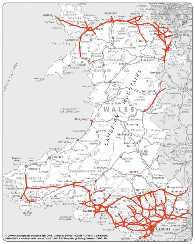
Figure 1   Major roads in Wales included in the 2011/12 noise mapping
           (based on 2010 traffic flow data)

                                    3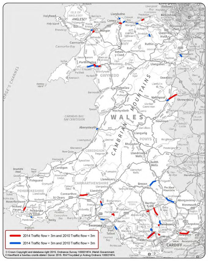
Figure 2      Major roads in Wales potentially to be included in the 2016/17
              noise mapping (based on 2014 traffic flow data)

Figure 3 shows which roads newly qualified as major roads in 2014 (around 60 km in
total length), and which previously major roads no longer qualified (again around 60
km in total length). Some of these roads might have crossed the threshold through
very small changes in traffic flow that are not significant in noise terms, while others
may be associated with more significant changes, including new or closed roads.

                                           4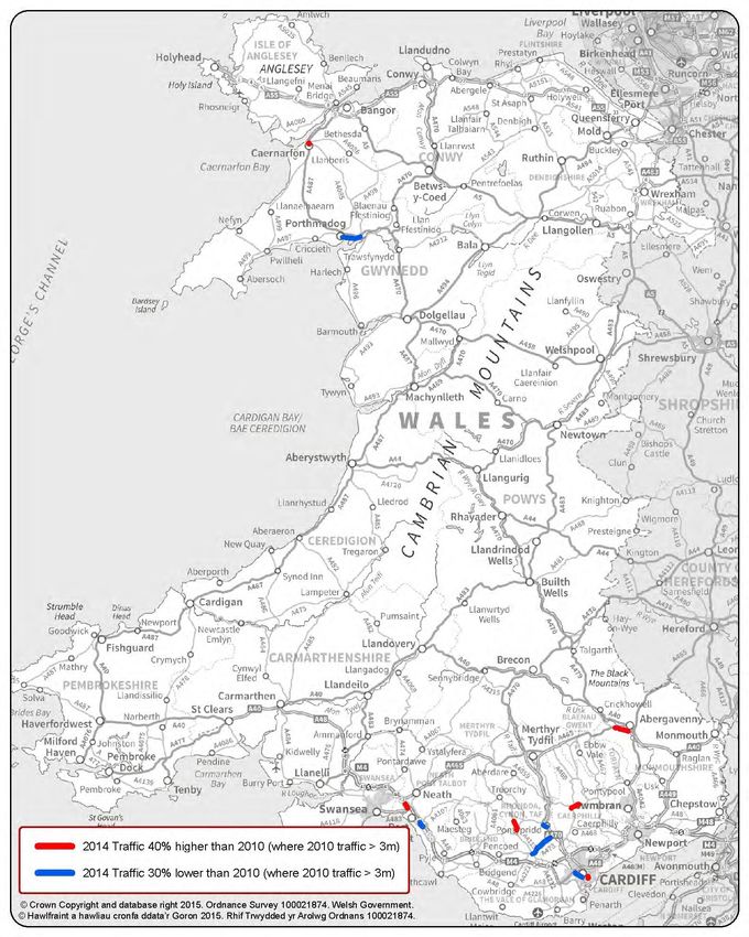
Figure 3     Changes to which roads meet the major road definition in terms of
             traffic flow between 2010 and 2014

To illustrate the more significant changes in traffic flows, Figure 4 below shows which
major roads were subject to traffic flow increases of 40% or more (around 10 km of
road), or decreases of 30% or more (around 20 km of road), between 2010 and
2014. This roughly equates to a change in noise level of 1.5 decibels or more, which
may well be noticed by nearby residents.

                                          5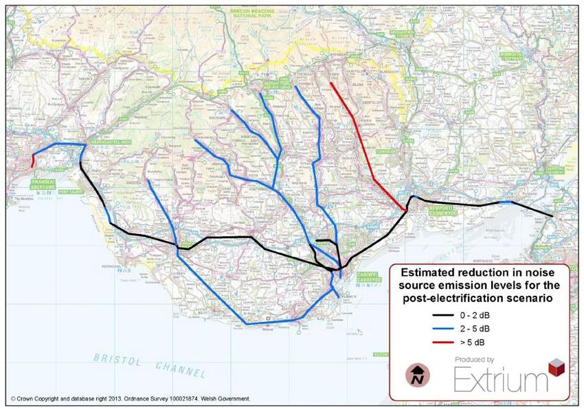
Figure 4        Major roads whose traffic flow changed significantly5 between
                2010 and 2014

Figure 5 below gives an indication of the spatial distribution of transport-related noise
complaints logged by the Welsh Government under the current noise action plan. All
but three of these complaints relate to noise from motorways or trunk roads.

5
 If traffic mix and speed and road surface remain unaltered, an increase in traffic flow of 40% or a
decrease of 30% roughly equates to an increase or decrease in sound emission of 1.5 decibels.

                                                   6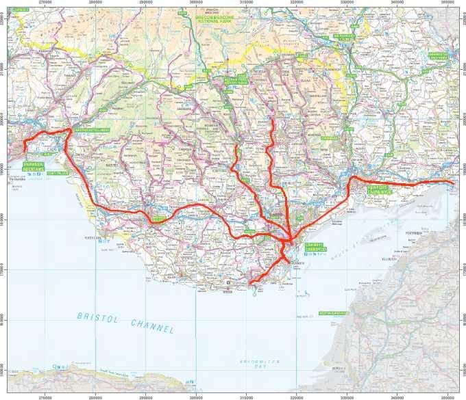
Figure 5             Spatial distribution of transport-related noise complaints logged
                     by the Welsh Government from April 2013 to September 2015

© Crown Copyright and database right 2015. Ordnance Survey 100021874. Welsh Government.

Considering the roads newly qualifying as major roads, those subject to significant
changes in traffic flow and those associated with complaints, to which may be added
those where engineering measures such as noise barriers have significantly altered
noise exposure, the major road noise maps warrant a full update in 2016/17.

                                                                 7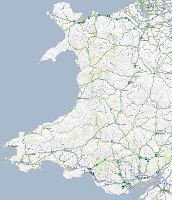
4         Railways

The Directive requires noise mapping for major railways (those designated by the
member state that have more than 30,000 train passages per year) and railways
within agglomerations. Not being the infrastructure owner, the Welsh Government
does not itself currently hold the detailed rail traffic data that would be necessary for
a full reassessment of noise levels on these lines, but it is not conscious of changes
in train numbers between 2011 and 2015 that would be likely to significantly affect
the extent of railways meeting the major railway definition6. Significant changes to
the network, notably the arrival of electric locomotives, are however envisaged for
the second half of the decade, ahead of the 2021/22 round of noise mapping.

Figure 6             Major railways in Wales

© Crown Copyright and database right 2012. Ordnance Survey 100021874. Welsh Government.

6
  Officials’ attention was drawn in the summer of 2015 to the doubling of a stretch of track between
Wrexham and Chester as having the potential to result in a significant increase in rail traffic. However,
an inspection of the current timetable showed that passenger services between those two stations
amounted to less than 50% of the 30,000 train passages per year required to qualify as a major
railway for noise mapping purposes. It was judged unlikely that additional passenger services plus
freight would cause traffic on this line to exceed 30,000 train passages per year by 2016.

                                                                 8
Figure 7 Results of an investigation carried out for the Welsh Government
by Extrium Limited into the estimated changes in noise levels
likely to come with electrification7
Electric locomotives are considerably quieter than the equivalent diesel locomotives,
and electric freight locomotives would provide a particular benefit at night-time, as
this is when freight movements often occur. Based on Network Rail projections at the
time of writing, electric trains are expected to begin running from the Severn Tunnel
to Cardiff in 2017, and from Cardiff to Swansea by the end of 2018. Most of the
“priority areas” identified in the noise action plan for Wales 2013-2018 are along this
line. The rest are on the Valley Lines, which are also due to be electrified. The initial
assumption is that work to install the new infrastructure on the Valley Lines will be
delivered between 2019 and 2024.
Furthermore, on 30 June 2015 the Minister for Economy, Science and Transport
revealed that work towards an integrated Metro system, estimated to cost £500-600
million, to serve the growing public transportation needs of the Cardiff Capital City
Region, would be an integral part of Welsh Government negotiations for an all-Wales
passenger rail franchise. At this stage there are many options for modes of transport,
including light rail, heavy rail, bus rapid transit and trams, but delivery work could
begin as early as 2017.
7
These noise reductions assume a uniform 50% increase in passenger vehicles (through longer
trains, more trains or a combination of the two) on all lines to be electrified, and that all passenger
vehicles running are of an electrified type. This may well not be the case in the centre of Swansea, so
reductions there may not be as high as suggested on this map. Where the increase in passenger
services is not as high as 50%, greater noise reductions may be achieved.
9Owing to the staged introduction of electric trains from 2017 on all the currently
identified major railways in Wales (and some Valley Lines that are not currently
designated as major railways but may be identified as such in due course), and work
to deliver the Metro expected to begin on a similar timescale, any new noise maps
produced in 2017 to show the situation in 2016 would be likely to be out of date
almost as soon as they were published. On the other hand, the maps produced in
2011/12 are considered by government to be reasonably representative of the
railway noise situation as it will be up until electrification and the coming of the Metro.
Views were sought by e-mail from the Welsh Government’s noise contacts in the rail
industry, in the summer of 2015, as to whether they considered a revision to the
noise maps (to represent the situation in 2016) necessary for the purposes of the
Environmental Noise Directive and noise action planning, or whether they
considered the 2011/12 noise maps to remain sufficiently representative of the
situation to not require updating until after electrification of the lines in question. The
single view forthcoming was that there was a good case, as the Welsh Government
had outlined, for deferring the production of further noise maps for Wales until the
coming into force of the mandatory EU calculation methods.
It is therefore proposed to neither revise the major railway definitions nor recalculate
railway noise levels until after the bulk of the planned electrification works have been
completed, by which time new noise mapping using harmonised EU calculation
methods will be called for. The railway noise maps produced in 2011/12 are
considered fit to be retained in 2017 as showing the noise situation in 2016.
5 Industry
Officers in Natural Resources Wales (NRW) familiar with the major industry in and
around the three Welsh agglomerations were asked in the summer of 2015 to
visually inspect the 2011/12 noise maps and provide the Welsh Government with a
view on whether there had been any significant changes to major industrial noise
sources since 2011, or if any were currently under construction or expected to close
down by 2016, thereby resulting in significant changes to the noise maps.
Out of 53 industrial sites in and around the three agglomerations, NRW identified 12
sites whose status had been or would be subject to significant change, including
several sites closing completely and a large new incinerator becoming operational in
Cardiff. On this basis, a recalculation of industrial noise levels in 2016/17 appears to
be warranted. A comparison of the industrial noise maps generated in 2011/12 and
2016/17 should reflect real changes in industrial noise levels across Wales’ largest
towns and cities, as differences between the two sets of maps will be determined
primarily by real world changes to the spatial distribution of active industrial sites.
It should be noted, however, that strategic noise maps do not provide much useful
information when it comes to assessing the likelihood of significant adverse impacts
being felt by people living near to specific industrial sites. This will depend more on
the characteristics of the specific sound sources that are audible off-site, the level of
background masking sound and the overall context.
106 Agglomerations
We also looked at whether there was a case for revising the agglomeration
boundaries used in 2011/12. Within agglomeration boundaries, noise levels from not
only major roads and major railways but all roads, railways and major industrial
sources are mapped.
The existing agglomeration boundaries were defined using 2001-census “urban
settlements” data, with the addition of green spaces on the periphery of the
settlements that local authorities indicated they wished to nominate as “quiet areas
within agglomerations” under the Environmental Noise Directive.
Figure 8 Agglomerations in Wales
We have considered whether urban expansion since 2001 warranted a new set of
agglomeration boundaries being introduced for noise mapping purposes in 2015/16.
These new boundaries could be defined using 2011-census “built-up area” data
released in June 2013. However, it appears that the 2011-census “built-up areas”
have been calculated in a different way from the 2001 “urban settlements”, and their
adoption would introduce changes to the noise maps that are not solely the result of
changes to the noise situation in the real world.
Significantly, either due to the change in definition method or small-scale
developments occurring between existing settlements in the intervening years, towns
such as Pontypridd, Caerphilly, Ystrad Mynach and Cwmbran would now be
included in the agglomerations. These towns existed at the time of previous rounds
of noise mapping, but sat outside the agglomerations. Mapping them as part of the
agglomerations in 2016/17 would change the noise maps significantly in areas where
the noise situation and population had not significantly changed, and so affect the
population exposure statistics in a way that could be potentially misleading.
11Figure 9 Agglomerations in Wales if redefined using 2011 data
Further points to bear in mind with regard to agglomeration noise mapping and
action planning are the expectations that local authority boundaries will go through
significant changes during the second half of this decade, and work on the Metro
system will begin that will affect both road and rail use in and around the Cardiff and
Penarth and Newport agglomerations.
Aiming to ensure that the only changes introduced to the noise maps in 2016/17
should reflect real-world changes to the noise situation since 2011, it is considered
unhelpful to amend the agglomeration boundaries for noise mapping purposes at this
time. Rather it is recommended that the agglomeration boundaries be revised based
on the latest “built-up area” data ahead of the 2021/22 round of noise mapping, when
all the noise levels will be recalculated using harmonised EU calculation methods.
Views were sought by e-mail from the Welsh Government’s noise contacts in the six
local authorities currently covering the three agglomerations, as to whether they
considered it necessary to recalculate the noise levels for their agglomerations in
2016/17, or whether the current noise maps remained sufficiently representative to
last until the coming into force of the mandatory EU calculation methods. The only
response received favoured retaining the current noise maps until 2021/22.
7 Conclusion
Having reviewed the noise maps, it is considered necessary to produce new maps in
2016/17 for major roads across Wales and industry in agglomerations. The 2011/12
maps for railways and for non-major roads in agglomerations may be retained as
representative enough of the situation in 2016, with new maps required in 2021/22.
12You can also read