Rice bike ride and Camargue horses - Arles - Chemins des parcs
←
→
Page content transcription
If your browser does not render page correctly, please read the page content below
PNR Camargue
In partnership with
OT Arles
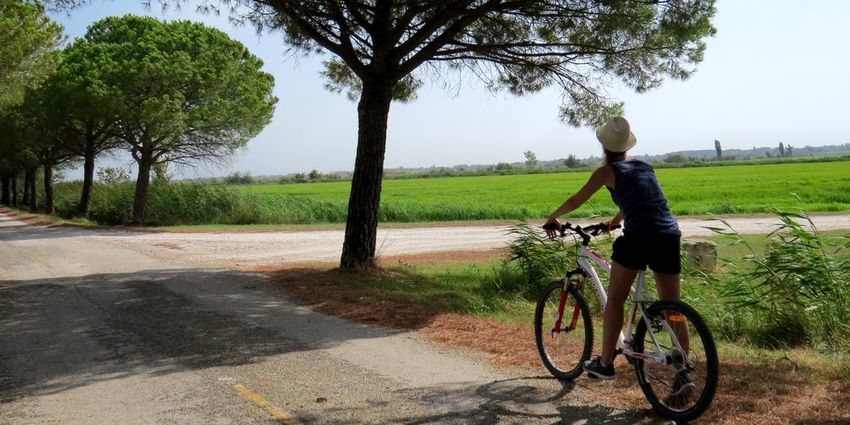
Rice bike ride and Camargue horses
Arles
Cycliste devant une rizière (Laurie Vanel - PNR Camargue)
Between ponds and Grand-Rhône, this Useful information
intimate circuit takes you to the heart Practice : BIKE
of a domesticated Camargue ...
Duration : 4 h
From the village of Sambuc, go for a hike along the Grand
Rhone and the lake of Fournelet. This walk takes you Length : 29.6 km
through paths and intimate roads Horses, manades but also Trek ascent : 7 m
ornithological observatory and rice paddies will punctuate
the route punctuated with small typical farmhouses of Difficulty : Easy
Camargue.
Type : Boucle
Themes : Farming and pastoralism,
Flora, Heritage and history
Accessibility : Hybrid bike
09/22/2021 • Rice bike ride and Camargue horses 1/9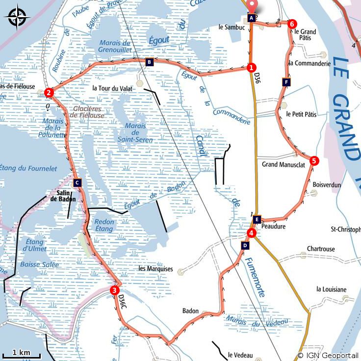
Trek

Departure : Route of Abrivado car park, Le Sambuc
Arrival : Le Sambuc
Markings : GR®

At the exit of the Sambuc village, heading south, take the bike path along the D36.

1 - Turn right on the C136 from Fiélouse to Sambuc. Continue for 6 km. Leave on the left the Jacques Bon
manade and the path that leads to the Tour du Valat.

2 - . At the crossroads of Mas de Fiélouse, turn left. Walk along the lake of Fournelet and Salin de Badon
(on the edge of the Camargue National Nature Reserve).

3 - Go left towards Salin-de-Giraud (bike marking). Pass Mas Saint-Bertrand and leave Mas Lou Verdau on
the left Continue and turn left on the C139 Petit and Grand Badon then continue for about 4.5 km.

4 - At the intersection of the D36, turn left Go past the Peaudure hamlet and take a right on the pine tree
lane for 500 m. Head to the right to reach the C156 "Draille du Beurre". Follow this path for 3 km. Pass in
front of an old mill.

5 - At the crossing, turn left to join the village of Sambuc. Continue for 4.5 km.

6 - Turn left, towards the center of the village. Continue for 1 km. At the junction with the Abrivado road
(D36), turn right onto the car park.

                                     09/22/2021 • Rice bike ride and Camargue horses                         2/9
On your path...
The Verdier marshes (A) The Tour du Valat Regional Nature Reserve
(B)
The Camargue Horse (C) Rice fields (D)
Butter's draille (E) IGP rice from Camargue (F)
09/22/2021 • Rice bike ride and Camargue horses 3/9All useful information
Advices
Stay alert on the D36, dangerous and busy road!
Respect the rules of the road on roads open to public traffic.
The Tour du Valat is not accessible to the general public, any exceptional opening is announced in
advance on the website of the Tour du Valat.
Ornithological observatory of the Grenouillet located on the path of Fiélouse, possibility to stop to
admire the scenery and the wildlife at 2 m height from the ground.
Altimetric profile
Min elevation 0 m
Max elevation 4 m
Transports Access
Envia transport network : Agglo 10 > Arles/Salin- 24 km south-east of Arles, by the D570 and the
de-Giraud by the Sambuc >> www.tout- D36.
envia.com; www.pacamobilite.fr
Advised parking
Parking Route de l’Abrivado, Le Sambuc
09/22/2021 • Rice bike ride and Camargue horses 4/9Information desks
Domaine de La Palissade
BP 5, 13129 Salin-de-Giraud
palissade@parc-camargue.fr
Tel : +33 (0)4 42 86 81 28
http://www.palissade.fr/
OT Arles
9 Boulevard des Lices, 13200 Arles
ot-arles@arlestourisme.com
Tel : +33 (0)4 90 18 41 20
http://www.arlestourisme.com/fr/
09/22/2021 • Rice bike ride and Camargue horses 5/9On your path...
The Verdier marshes (A)
Verdier Marshes consist of four former fishponds totalling 120 ha with
diversified habitats (reed beds, scirpiies, tamarisk groves). The site was set up
for a herd of Camargue cows which ensures pasture pressure in the pond and
keeps the marshes open. The Verdier Marshes are attractive to waterbirds,
giving them a real ornithological interest. In free access, the site has an
observation platform.
Attribution : Tour du Valat
The Tour du Valat Regional Nature Reserve (B)
Created in 1954 by Luc Hoffmann, the Tour du Valat is a research center
specializing in the conservation of Mediterranean wetlands. Initially oriented
towards ornithology, the research then extended to all the fauna and flora of
the Mediterranean wetlands. The estate is classified as a Regional Nature
Reserve and covers 1845 ha. There are natural habitats characteristic of the
Camargue, more than 600 species of plants and more than 300 birds.
Attribution : Opus Species - PNR Camargue
The Camargue Horse (C)
The Camargue horse is a very old breed (1978) and would descend from the
prehistoric horse of Solutré. Symbol of the Camargue, with a gray-white dress,
short ears and a shaggy mane, it is small, about 1.45 m at the withers. His dark
hair of birth takes its final colour white-gray when he is around 4 years old.
Raised in the Camargue, he is the companion of the guardian and the working
tool for raising bulls. Breeding and reproduction criteria are strict to preserve
his breed.
Attribution : Marjorie Mercier - PNR Camargue
09/22/2021 • Rice bike ride and Camargue horses 6/9Rice fields (D)
Rice farming has been present in the Camargue since the post-war period.
Complex, this culture follows several stages: lifting, tillering, bolting, return and
flowering. The land is flooded to promote the germination of rice grains and
prevent the proliferation of fungi. Rice farming therefore requires freshwater
irrigation and extensive drainage to develop the saltiest land. Huge amounts of
water between the two arms of the Rhône (400 million m3 per year) are
needed.
Attribution : Muriel Cervilla - PNR Camargue
Butter's draille (E)
Two assumptions are used to explain the origin of the name of this draille.
Literally "drinking path", it would be at the time, the original access path that
cattle borrowed to drink in the Rhone. It would also remind the presence of
islands, formed by the Rhone, conceded to owners who agreed to pass
travelers in exchange for a little butter. The peasants paid their taxes to the
Arles consuls with goods and food.
Attribution : Chloé Scannapiéco - PNR Camargue
IGP rice from Camargue (F)
Sown at the end of April, the rice comes out of the water in May and is
harvested between September and October. Production is now adapting to
new consumption and is abandoning the cultivation of round rice for long and
fine rice, which is more appreciated. They also grow red rice with a naturally
colored caryopsis (fruit) and wild rice. In 2000, the Camargue rice obtained a
sign of European quality, the Protected Geographical Indication (PGI),
recognition of the know-how of the producers.
Attribution : Marjorie Mercier - PNR Camargue
09/22/2021 • Rice bike ride and Camargue horses 7/9• En aucun cas les auteurs des contenus de ce site ne sauraient être tenus pour responsables de
problèmes ou d'accidents sur les itinéraires cités.
• Cependant, nous comptons sur vous pour signaler toutes contradictions importantes entre cette
fiche et le terrain.
• Pensez également à signaler les éventuels problèmes rencontrés pendant votre balade sur http://
sentinelles.sportsdenature.fr (erreur de balisage, panneau défectueux, pollution, conflit d'usages…).
• La vente de cette fiche est autorisée au coût d'impression.
• Ne pas jeter dans la nature.
L'outil Geotrek a été financé par l'Union européenne, le Parc national des Ecrins et le Parc national du
Mercantour.
Le projet Chemins des Parcs est financé par la Région Provence-Alpes-Côte-d'Azur et les Parcs naturels
régionaux des Alpilles, de Camargue, du Luberon, du Queyras et du Verdon.
Ce projet partenarial rassemble également le Comité Régional du Tourisme, les agences départementales
de développement touristique, les offices de tourisme et les syndicats d'initiative.
• The authors of this website will in no case be held responsible for problems or accidents on the
routes mentioned.
• We count on you to point out any inconsistency between this content and the field itineraries
• Please report any problems encountered on the routes (route marking problems, defective panels,
pollution, conflict of uses ...) on http://sentinelles.sportsdenature.fr
• The sale of this sheet is authorized at the cost of printing
• Please don’t litter
The Geotrek tool was funded by the European Union, the Ecrins National Park and the Mercantour
National Park.
The Chemins des Parcs project is funded by the Provence-Alpes-Côte-d'Azur Region and the regional
nature parks of Alpilles, Camargue, Luberon, Queyras and the Verdon.
This project was developed in partnership with the Regional Tourism Committee, the departmental tourist
development agencies, and tourist offices.
09/22/2021 • Rice bike ride and Camargue horses 8/9Avec le soutien de
09/22/2021 • Rice bike ride and Camargue horses 9/9You can also read