River Medway Public Inquiry 2021 - Inspector: Anne Jordan BA (Hons) MRTPI
←
→
Page content transcription
If your browser does not render page correctly, please read the page content below
River Medway Public Inquiry 2021
Inspector: Anne Jordan BA (Hons) MRTPI
Joint Statement of Case
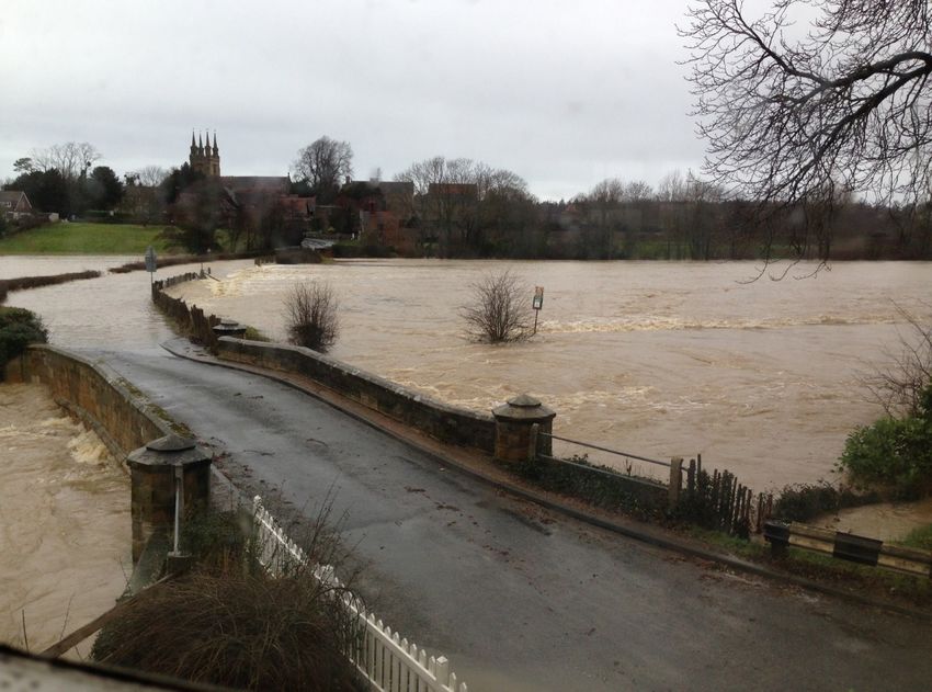
Bridge House, Rogues Hill, Penshurst
The Yews, Rogues Hill, Penshurst
Colquhouns Cottage, High Street, Penshurst
Rogues Hill, Penshurst on the 24th December 2013 when the flood level
peaked at 29.50m AOD
Photo’ taken at 9.09am after the EA commenced impounding of the FSA at 5.55am.1. Introduction This is a joint Statement of Case by three households in Penshurst. All three submitted objections to the Environment Agency’s submission to the Secretary of State to increase the maximum stored water level in the Leigh Flood Storage Area (FSA) from 28.05 m AOD to 28.6 m AOD. We have decided on a joint Statement of Case as many of our objections are similar. We hope that this will reduce any duplication that would occur if we submitted three individual Statements of Case. We hope that all three households will be able to speak at the inquiry individually as well as jointly on those matters that are common. 2. Particulars of the Case All three households suffered from flooding, particularly in December 2013 when the Environment Agency raised the water level to its current legal maximum of 28.05m AOD. Bridge House and Colquhouns Cottage submitted to the Environment Agency claims for compensation for losses incurred. The Environment Agency accepted liability and paid compensation to both Bridge House and Colquhouns Cottage. Although the River Medway (Flood Relief) Act 1976 states that “full compensation” must be paid, the Environment Agency reduced both claims and only paid partial compensation. We consider this reduction to be unlawful. All three households have lived in Penshurst for up to 26 years and know that some flooding occurs to our properties before the Environment Agency impound the FSA. This level of flooding is covered by legal agreements known as “right to flood agreements.” However, higher flooding occurs when the Environment Agency impound the FSA. December 2013 is the best recorded example of this, when all three properties were flooded to a higher level than covered by the right to flood agreements. The Yews also suffered losses due to flooding of out buildings in December 2013. This occurred on land not covered by their “right to flood agreement.” No claim was submitted to the EA in order to preserve insurance premiums and property value. All three households have stated that they recognise the benefits to downstream properties that increasing the water level in the FSA would bring. All three properties just want the Environment Agency to accept that there are downsides to the upstream properties (Penshurst) and to address resolving these downsides rather than denying they exist. Our MP, Tom Tugendhat has supported the proposal to raise the water level in the FSA, but he recognises that the Environment Agency must address the downsides for the upstream residents in Penshurst. He wrote to the Chief Executive of the Environment Agency on the 6th August 2020 asking that he ensured that this happened. It has not happened, we are now having a Public Inquiry. Copy of letter attached. We shall wish to refer to this letter.
3. Objections

The Environment Agency have submitted our objections, so they are already available to the
Inquiry. We do not wish to add to the paperwork submitted so will not duplicate matters by
submitting them again. We will refer to these objections.

   4. Other submissions

The Environment Agency have also submitted many other documents relative to their submission.
We will refer to those documents.

We do wish to refer to the independent 2018 detailed level survey of Bridge House and The Yews
that was commissioned by the EA and undertaken by J C White. This accurate survey together
with a measuring station located by Bridge House would provide empirical evidence from which
water flows and flood levels could be accurately determined.

We may also wish to refer to documents that have not yet been submitted. But understand that
these can be submitted as “Proof of Evidence” documents. We will be able to understand more
about the Inquiry process after the Pre Inquiry meeting scheduled for the 16th March 2021.

   5. Ongoing Negotiations
All objections remain outstanding. The EA have not negotiated any of these matters, merely
dismissed our objections.

Bridge House raised 29 objections to the submission.

One objection (3.9) has been partially resolved. The Environment Agency said they would replace
the Gauge Board with one that measures to 30.00m AOD. This has not happened. Instead the
existing Gauge Board has been extended, but only to 29.7m AOD. If this was the 29th objection to
be resolved we would accept it, but as it is the 1st objection, it is disappointing.

28 objections remain unresolved.

The Yews raised 20 objections to the submission.

20 objections remain unresolved.

Colquhouns Cottage raised 13 objections to the submission.

13 objections remain unresolved.

One common objection is the need for a measuring station, not just a Gauge Board, after the
confluence of the rivers Medway and Eden. This must be at the pinch point which occurs at
Rogues Hill between the two bridges, where the greatest risk to life occurs. The EA proposed to
local residents that this measuring station be situated 400 metres downstream at a bridge that only
serves Southern Water’s sewage works. All residents consulted strongly opposed this position,
stating that the bridge at Rogues Hill is the most appropriate location, but the EA have disregarded
our views.
6. Conclusion

We hope that this Statement of Case is sufficient to meet the requirements of the Inquiry, and to
allow us to speak at the Inquiry.

   7. Statement of Case submitted by:
      Bridge House                Kevin & Jenny Storey

      The Yews                    Jeremy & Katharina Thompson

      Colquhouns Cottage          Tim Burraston & Gillian Pallen

Contact via

kevinstorey1@gmail.com

Attachments:

   1. Tom Tugendhat letter to Sir James Bevan 6th August 2020

   2. 1800155 - Penshurst_05 - Sheet_1

   3. 1800155 - Penshurst_05 - Sheet_2
6 August 2020 Sir James Bevan Chief Executive Environment Agency C/O Orchard House Endeavour Park London Road Addington West Malling Kent ME19 5SH Our Ref: TT38295 Dear Sir James, Please find enclosed a copy of a letter that I have been copied into from Mr Kevin Storey of Bridge House, Rogues Hill, Penshurst, Tonbridge, Kent, TN11 8BQ, and was sent to Tim Connell at the Environment Agency on 31 July 2020, in relation to the application for the enlargement of the Leigh Flood Storage Area and amendment to the River Medway (Flood Relief) Act 1976 As you can see, Mr Storey is deeply disappointed that the Environment Agency has sought to re-write the submission from Penshurst residents to the consultation regarding the amendment to the act that has been submitted to the Department for Environment, Food and Rural Affairs (DEFRA). My office has been in touch with Mr Storey and he is concerned about the reluctance of the Environment Agency to agree to three asks of residents in Penshurst which would address their situation while also allowing the much needed expansion to go ahead, considering the substantial benefit for communities downstream. These asks are that a measuring station be installed at Penshurst to provide evidence of timing and levels so that actual flood levels after the confluence of the River Medway and River Eden would be known, that the Environment Agency pay the cost of making Mr Storey’s neighbours studio resilient to flood, and that agreement is reached towards the implementation of already given planning permission at Bridge House to defend it from flood water. I would be grateful if you could let me know whether the Environment Agency could look at these three issues as part of this process, in order to ensure that residents in Penshurst also benefit from the scheme. I know that Mr Storey and his neighbours would appreciate the opportunity to meet with you and discuss this too. I look forward to hearing back from you. I have copied this letter to the Secretary of State for Environment, Food and Rural Affairs, the Floods Casework Team at DEFRA and the Area Director of the Environment Agency
Best wishes,

                                                                     TOM TUGENDHAT

                                   CC:
                                   The Rt Hon George Eustice MP, Secretary of State for Environment, Food and Rural Affairs
                                   Floods Casework Team, Department for Environment, Food and Rural Affairs
                                   Sally Harvey, Area Director for Kent and South London, Environment Agency

Powered by TCPDF (www.tcpdf.org)
Copyright and other intellectual property rights in this drawing remain the property of
J.C.White Geomatics Limited. The plans may not be copied, used or passed to any third party
for any other purpose without the express consent of J.C.White Geomatics Limited.
LEGEND
1
Sheet Layout
3
1 2
Ro
gu
es
Hi
3 ll
Bridge
House
2
4
1
CONTROL SCHEDULE
STATION EASTING NORTHING HEIGHT DESCRIPTION
100 552928.198 143604.050 29.003 Peg
101 552912.251 143605.041 28.337 Peg
102 552892.722 143603.352 28.072 Peg
103 552900.585 143616.050 28.266 Peg
104 552924.395 143633.811 29.648 Peg
105 552892.816 143647.785 29.635 Nail
106 552835.557 143727.350 29.026 Nail
107 552962.511 143686.923 28.383 Peg
108 552949.620 143674.920 28.157 Peg
109 552957.534 143670.053 28.344 Peg
110 552975.860 143655.385 28.718 Peg
111 552993.697 143670.315 28.512 Peg
112 553006.566 143680.657 28.790 Peg
113 553012.800 143667.625 28.931 Peg
114 553005.295 143658.619 29.039 Nail
115 552996.877 143651.689 29.043 Nail
116 553006.172 143648.980 29.278 Nail
117 553013.102 143639.465 29.694 Nail
118 553006.316 143630.815 30.142 Nail
119 552993.483 143625.042 30.131 Nail
120 552984.379 143616.473 30.659 Nail
121 552975.827 143590.867 31.057 Nail
122 552964.272 143628.746 30.138 Nail
123 552983.668 143643.240 29.291 Nail
Geomatics Limited
Shrine Barn, Shrine Farm, Sandling Road, Postling, Hythe, Kent, CT21 4HE
Tel : 01303 261212 Fax : 01303 264040
Email : survey@jcwhite.co.uk Web site : www.jcwhite.co.uk
GPS Surveys Setting Out
Volumetric Surveys Boundary Disputes
Topographical Surveys Engineering Surveys
Measured Building Surveys Deformation & Settlement Surveys
Laser Scanning Scan to BIM Modelling
CLIENT
Dalcour Maclaren
JOB TITLE
Bridge House / The Yews,
Rogues Hill, Penshurst,
Tonbridge, TN11 8BQ.
DRAWING TITLE
Limited Level
Topographical Survey
JOB No. 18/00/155 DATE July 2018
SURVEYED BY IOF & PV DRAWN BY IOF & PV
SCALE 1:200 DWG. No. 1 REV. No.
CAD PLOT DATE ORIGINAL SHEET SIZE CADFILE NAME
14.08.2018 A0 1800155 - Penshurst_05.dwgCopyright and other intellectual property rights in this drawing remain the property of
J.C.White Geomatics Limited. The plans may not be copied, used or passed to any third party
for any other purpose without the express consent of J.C.White Geomatics Limited.
LEGEND
1
Sheet Layout
3
1 2
11
10 12
9
8
13
The
Yews
14
Ro
g ue
sH
ill 7
3
15
6
Bridge
5
House
16
2
4
1
CONTROL SCHEDULE
STATION EASTING NORTHING HEIGHT DESCRIPTION
100 552928.198 143604.050 29.003 Peg
101 552912.251 143605.041 28.337 Peg
102 552892.722 143603.352 28.072 Peg
103 552900.585 143616.050 28.266 Peg
104 552924.395 143633.811 29.648 Peg
105 552892.816 143647.785 29.635 Nail
106 552835.557 143727.350 29.026 Nail
107 552962.511 143686.923 28.383 Peg
108 552949.620 143674.920 28.157 Peg
109 552957.534 143670.053 28.344 Peg
110 552975.860 143655.385 28.718 Peg
111 552993.697 143670.315 28.512 Peg
112 553006.566 143680.657 28.790 Peg
113 553012.800 143667.625 28.931 Peg
114 553005.295 143658.619 29.039 Nail
115 552996.877 143651.689 29.043 Nail
116 553006.172 143648.980 29.278 Nail
117 553013.102 143639.465 29.694 Nail
118 553006.316 143630.815 30.142 Nail
119 552993.483 143625.042 30.131 Nail
120 552984.379 143616.473 30.659 Nail
121 552975.827 143590.867 31.057 Nail
122 552964.272 143628.746 30.138 Nail
123 552983.668 143643.240 29.291 Nail
Geomatics Limited
Shrine Barn, Shrine Farm, Sandling Road, Postling, Hythe, Kent, CT21 4HE
Tel : 01303 261212 Fax : 01303 264040
Email : survey@jcwhite.co.uk Web site : www.jcwhite.co.uk
GPS Surveys Setting Out
Volumetric Surveys Boundary Disputes
Topographical Surveys Engineering Surveys
Measured Building Surveys Deformation & Settlement Surveys
Laser Scanning Scan to BIM Modelling
CLIENT
Dalcour Maclaren
JOB TITLE
Bridge House / The Yews,
Rogues Hill, Penshurst,
Tonbridge, TN11 8BQ.
DRAWING TITLE
Limited Level
Topographical Survey
JOB No. 18/00/155 DATE July 2018
SURVEYED BY IOF & PV DRAWN BY IOF & PV
SCALE 1:200 DWG. No. 2 REV. No.
CAD PLOT DATE ORIGINAL SHEET SIZE CADFILE NAME
14.08.2018 A0 1800155 - Penshurst_05.dwgYou can also read


