RMAG GEOHIKE 2021 GUIDEBOOK - BEN BURKE, PHD JUNE 2021 - LOOKING SOUTHWEST FROM DAKOTA RIDGE TO RED ROCKS. PHOTO BY ANNE STEPTOE - ROCKY MOUNTAIN ...
←
→
Page content transcription
If your browser does not render page correctly, please read the page content below
RMAG Geohike 2021 Guidebook
Ben Burke, PhD
June 2021
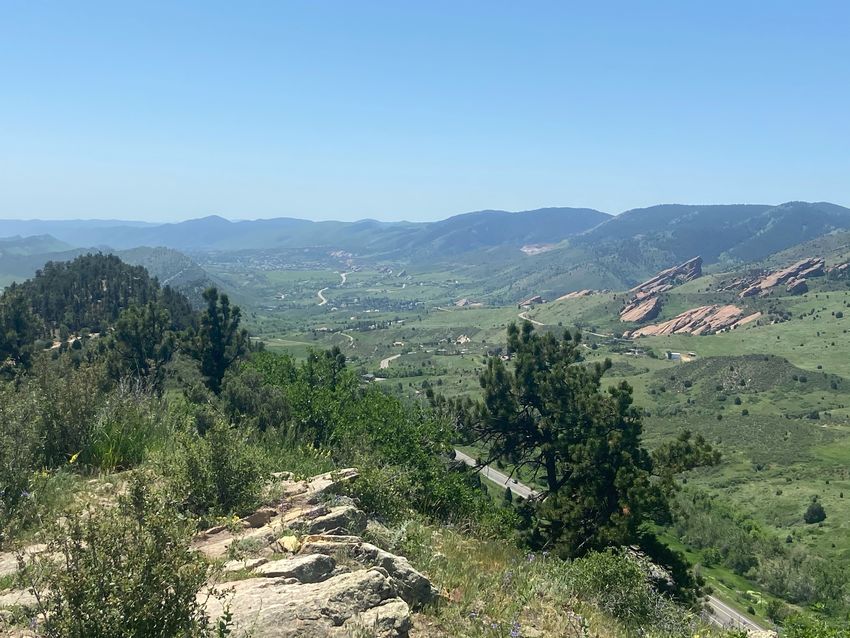
Looking Southwest from Dakota Ridge to Red Rocks. Photo by Anne Steptoe
1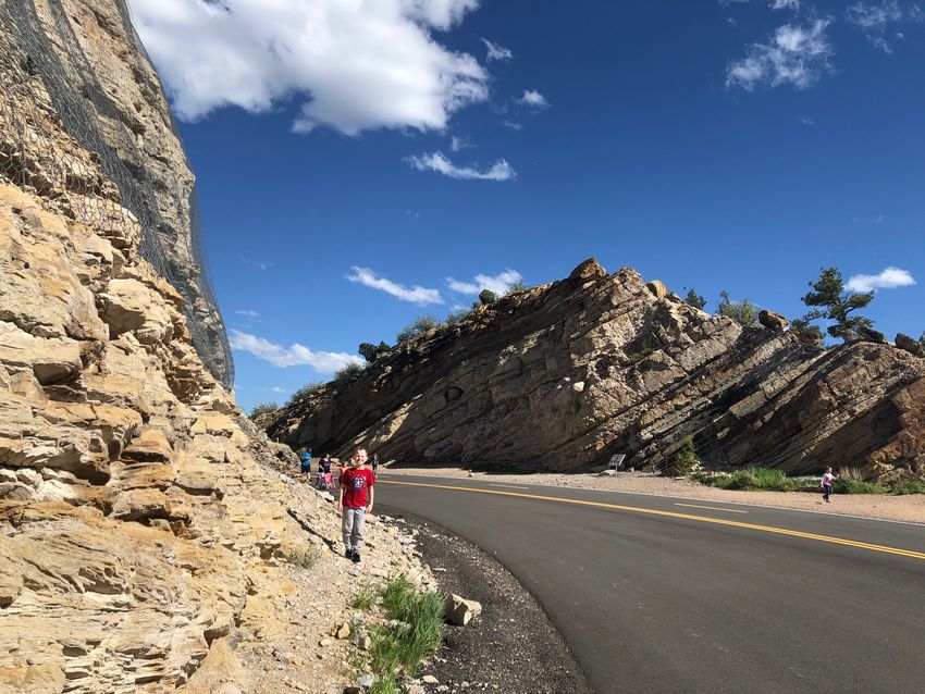
Geohike 2021

Thank you for supporting the Rocky Mountain Association of Geologists by signing up for the Geohike 2021
Challenge! This guidebook seeks to pique your geologic curiosity as you hike the Red Rocks to Dakota Ridge
trail. This guidebook is not written with any particular starting or stopping point in mind, nor with specific
directionality in mind. You may hike the trail clockwise or counter-clockwise. You may park at any of the
trail access points. Some of these parking locations are directly on the trail; others are a short walk from
the trail.

Logistical Details

Parking Locations

 Lot                                Address                                              Latitude Longitude
 Stegosaurus Lot                    County Rd 93 & I-70 (southeast corner),              39.69805 105.2034
                                    Golden, CO 80401
 Dinosaur Ridge (east side)         S Rooney Rd & W Alameda Pkwy, Morrison               39.68632 105.1931
                                    CO 80465
 Dinosaur Ridge (west side)         County Rd 93 & W Alameda Parkway,                    39.67998 105.1969
                                    Morrison CO 80465
 Red Rocks Park at Jurassic         Red Rocks Park Rd * Jurassic Rd, Morrison            39.67093 105.1949
 Road                               CO 80465
 Red Rocks Trail Rd &               Red Rocks Trail Rd & W Alameda Parkway,              39.67269 105.2016
 Alameda Parkway                    Morrison CO 80465
 Matthews Winters Park              1103 County Rd 93, Golden CO 80401                   39.69592 105.2038

Public Transit & Alternate Transportation Details The Denver region is served by the Regional
Transit District (RTD) bus and rail service.
Nearest bus and rail station: From downtown Denver, take the W line west from Union Station to the end
of the line at the JeffCo-Government Center station. Take a rideshare or cab from the light rail station to
the Dinosaur Parking Lot. There is no bus service convenient to Dinosaur Ridge.

Digital Accessibility In addition to this document in PDF or paper format, consider downloading the
Mancos app from your favorite app store. This app allows you to see a geologic map at your current location,
custom set the transparency of the geologic map, and read a short description of the lithology.

Geographic & Geologic Summary

This hike traverses both the ridgeline of Dinosaur Ridge, also known as the Dakota Hogback, and provides
expansive views of the Denver Basin to the east, and the variable alluvium of the Mount Vernon creek valley.
The ridgeline is on the youngest rocks of the hike, the various sands and shales of the lower Cretaceous Dakota
Group. The western side of the ridge has the lowestmost Cretaceous rocks in the Denver Basin exposed,
as well as the Jurassic Morrison Formation. You are in the type locality of the Morrison Formation; the
town of Morrison is located a few miles south of the trail. The terrain of the valley varies between various
Quaternary alluvium and colluvium and the Permian.
The 1967 report by the US Geological Survey titled “Mountains & Plains: Denver’s Geologic Setting”
summarizes the geologic setting you will see throughout this hike:

                                                      2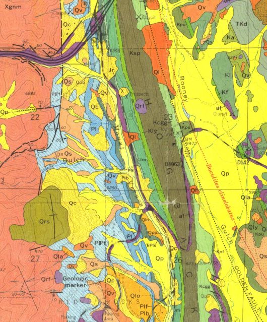
Figure 1: Parking Lot Location Map

                3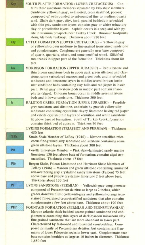
Figure 2: Geologic Map of the Dinosaur Ridge Area from Scott, 1972

                                4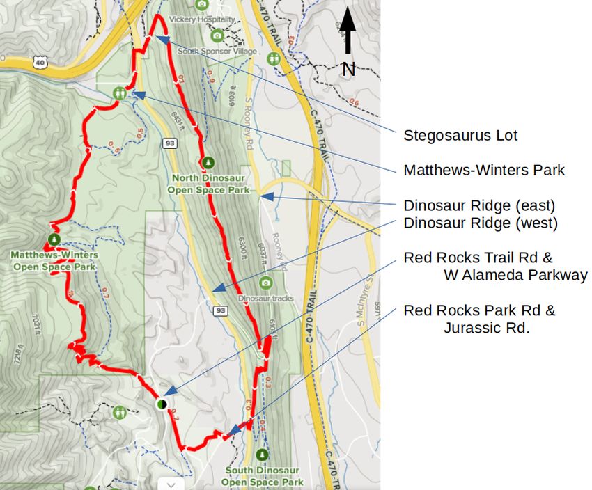
Figure 3: Geologic Map Descriptions of the Dinosaur Ridge Area from Scott, 1972
                                        5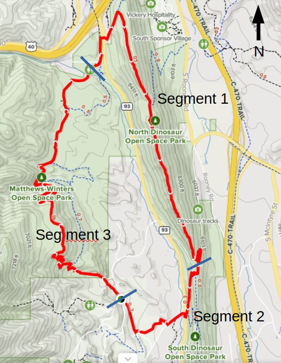
Figure 4: Hike Segments and Route Map

                 6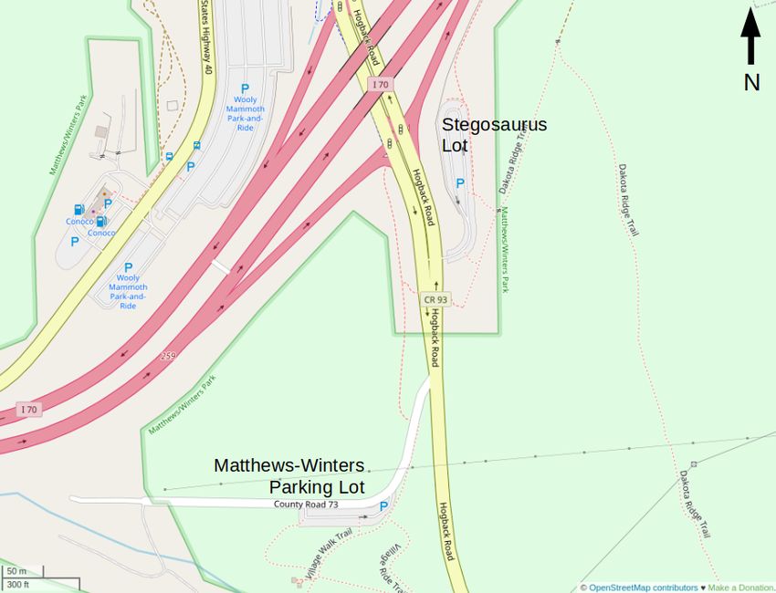
A slice of geologic history is exposed to view in the Denver, Colorado, area. Denver is situated on
      the High Plains near the east front of the Rocky Mountains. As one travels westward from Denver
      towards the mountains, successively older rocks are crossed–from the geologically younger rocks of
      the High Plains and the South Platte River valley to the older rocks of the foothills and the ancient
      rocks of the mountains.
      As one approaches the mountain front, an array of hills, ridges, and mesas partly hides the high
      mountains further west. One of these is Green Mountain, a large, rounded hill between Alameda
      Parkway and US Highway 6. Conglomerate, or naturally cemented gravel, hundreds of feet thick
      caps the hulking mass of Green Mountain. The gravel was deposited at a much higher level than
      the pediments by a still older steam, and is all that remains of a formerly more extensive deposit.
      The gravel, later cemented to form conglomerate, lies on slightly older volcanic mudflows and stream
      deposits known as the Denver Formation, the bedrock that underlies most of Denver at shallow depth.
      The most prominent hogback is formed of the Dakota Sandstone, a beach deposit of an ancient sea.
      Abundant ripple marks, still preserved, formed in the shallow water. The footprints of dinosaurs
      that walked the sandy beaches can still be seen on the sandstone layers. Older than the Dakota
      and farther to the west, upturned against the ancient rocks of the mountains are the colorful red
      sandstone monuments of the Fountain Formation, which frame Red Rocks Amphitheater and for
      which the amphitheater is named.

Segment 1: Northern Parking Lots to Alameda Parkway via Dakota Ridge

This location is a spectacular starting location for the hike. You are parked on the western side of Dinosaur
Ridge, the first hogback on the western edge of the Denver Julesberg Basin west of Denver, Colorado. This
segment can start either at the Matthews-Winters Open Space parking lot or at the Stegosaur parking lot.
The parking lot is situated in the Triassic Strain Shale Member of the Lykins Formation.There are two trails
away from the parking lot. One departs from the east end of the parking lot and crosses the exposed face
of the roadcut for the interstate highway. Although beautiful, this trail is a dead end. The other heads up
the hill from the south area of the lot. Quickly, you leave the Lykins Formation behind as you ascend the
ridge. Quickly, you move into the younger rocks of the Jurassic Morrison Formation and further upwards
in time, passing through the Lytle Formation, the oldest Cretaceous rock here. At the ridge, you are in the
Cretaceous Dakota Group. The Dakota Group contains several shale and sandstone units that you will see
throughout the hike along the ridgeline. This segment ends when you descend east of the ridgeline to the
road.
Your eastward view from the ridgeline is into the Denver Basin, with the City of Denver as well as the
Front Range metro region spread out before you. The topographic body in front of you in the foreground is
Green Mountain. It is capped by the Green Mountain Conglomerate and the Table Mountain Shoshonite, a
Paleocene-aged potassium rich basalt (Scott, 1972). Green Mountain has many trails on it and is popular
with hikers and mountain bikers. In the valley between the ridge you are standing on and Green Mountain
Colorado Route 470, a ring road to the City of Denver. The valley is covered to a large extent in the
Holocene-aged Piney Creek alluvium, however the underlying upper Cretaceous bedrock peeks out here and
there. The uppermost Cretaceous units exposed here are the Pierre Shale, a slope former, as well as the Fox
Hills Sandstone, a brightly colored set of outcrops seen at the base of Green Mountain. The fact that the
Fox Hills, an uppermost Cretaceous fluvial sandstone is juxtaposed near the Dakota Group sandstone and
shales, is made possible by an offset on the Golden Fault that is several thousand feet.
Your westward view from the ridgeline is the face of the Front Range. Most prominent on that is the reddish
sandstones of the Fountain Formation, a Pennsylvanian delta sequence that is exposed in several places
along the Front Range. Most prominent among those exposures are the outcrops at Red Rocks Park to the
south of your vantage point and further south at Roxborough State Park and Garden of the Gods. To the
north, the Fountain Formation outcrops near Boulder. In the valley below you to the west is the Morrison
Formation–mostly shale with lacustrine sandstone lenses–and the Lyons Sandstone.

                                                     7
Figure 5: Parking Lot Locations at the Matthews-Winters Park and Stegasaur Lots
8As you hike south, you will see Alameda Parkway rising up the east side of the ridge to meet the trail at the
ridgeline. There are parking areas at the base of the ridge on either side where the road is closed to vehicular
traffic. The trail connects the roadway to the ridgeline via a short jog on the east side of the ridgeline.
Alameda Parkway Trail Intersection
This segment of Alameda Parkway is a very popular natural history walk with world-class dinosaur tracksites
on view part way down the hill at a small semi-enclosed viewing area. At the top of the hill where Alameda
Parkways crests the ridge, a small roadcut reveals spherically weathering nodules, a few oil seeps, and
volcanic ash layers.
Figure 6: Alameda Parkway Crest at Dinosaur Ridge. Photo from north side looking southeast. Photo by
the author
Be careful to stay in the pedestrian section of the roadway and look both ways for both bicycle and tour bus
traffic. The Dinosaur Ridge Visitor’s Center operates a tour bus that traverses the exhibits along the ridge.
Rocky Flats Alluvium Outcrop Along Ridgeline
Approximately one mile south of the Dinosaur Parking Lot is a patch of Rocky Flats Alluvium. Scott, 1972,
describes the Rocky Flats alluvium as:
Reddish-brown pebbily silt and clay interlayered with gravel. Stones deeply weathered, and, in the
upper part of deposit, covered by calcium carbonate. Inferred Rocky Flats erosion channel preserved in
Mount Vernon Canyon and in wind-gap through Dakota hogback west of Green Mountain. Thickness
of alluvium 10-15 feet.
Segement 2: Dinosaur Ridge to Red Rocks Trail Road Parking Area
This segment begins with a short uphill from Alameda Parkway on Dinosaur Ridge up to the crest of Dinosaur
Ridge. You are in the Dakota Group of lower Cretaceous shales and sandstones. The trail has two short
switchbacks on the west side of the ridgeline just below the crest before connecting in a straight line with
Hog Back Road. You leave the Dakota Group sandstones behind as you leave area containing small trees
and enter open country. The trail traverses the lower Cretaceous Lytle and Jurassic Morrison formations.
Both are hardly noticeable on the trail since they are slope-forming lithologies that readily erode.
The trail crosses Hog Back Road via an unprotected crosswalk and stays on the north side of Red Rocks Park
Road between Hog Back Road and Jurassic Road where a small 12 vehicle parking area sits on the south
9side of the intersection. From this point, the trail is on the north side of Red Rocks Park Road. Through
open country, the trail traverses the Piney Creek and Louviers Alluvia to the intersection of Red Rocks Trail
Road and Alameda Parkway at a small 6 vehicle parking area. To the north of the trail, two houses and
some low, white sandstone outcrops are visible. These are outcrops of the Permian-aged Lyons Formation.
Segment 3: Red Rocks Trail Road Parking Area to Matthews-Winters Open
Space Parking
This segment of the trail traverses the highest elevations of the hike. Between the Matthews-Winters Open
Space parking area on the north end of the segment and the Red Rocks Trail Road parking area on the
south end of the segment, the sole bedrock lithology traversed by the trail is the famous Permian and
Pennsylvanian-aged Fountain Formation. This formation is informally known as the Red Rocks Formation,
for the concert venue south within the park from the trail.
The Fountain Formation is described by Scott, 1972, as:
Maroon arkosic thick-bedded coarse-grained sandstone and conglomerate containing this layers of
dark-maroon micaveous silty fine-grained sandstone that are more abundant in the lower part. Char-
acterized by festooned and torrential cross-bedding. Composed primarily of Precambrian detritus,
but contains rare fragments of lower Paleozoic rocks in lower park. Conglomerate near base contains
boulders as large as 10 inches in diameter. Thicness [up to] 1650 feet.
More recently, an entirely Pennsylvanian age has been proposed by Sweet (2015) based on field work to the
south at Manitou Springs, Colorado.
The highest elevation section of the segment traverses a flat to gently rolling landscape. This is a Holocene
rock slide deposit from the overlying Precambrian gneiss.
The southern end of the segment contains two spectacular outcrops of Fountain Formation that the trail
crosses between. The trail also traverses several types of alluvia and colluvia many of which are recent
(Pleistocene in age).
References
• Scott, Glenn R., 1972. Geologic Map of the Morrison Quadrangle, Jefferson County, Colorado. IMAP-
790. Scale 1:24,000, doi.org/10.3133/i790A.
• Sweet, Dustin E., Carsrud, Corbin R., and Watters, Aaron, 2015. Proposing an entirely Pennsylvanian
age for the Fountain Formation through new lithostratigraphic correlation along the Front Range.
Mountain Geologist 52 (2) 43-70.
• US Geological Survey, 1967. Mountains & Plains: Denver’s Geologic Setting. 23 pp. US Government
Printing Office, Washington, DC. doi.org/10.3133/70039249
10You can also read