SATURDAY WILSONS PROMONTORY NATIONAL PARK - TIDAL RIVER CAMP GROUND - Trailsplus
←
→
Page content transcription
If your browser does not render page correctly, please read the page content below
SATURDAY
                        27th FEB 2021
                6km - 21.1km - 55km – 110-115km

                TIDAL RIVER CAMP GROUND

  WILSONS PROMONTORY NATIONAL PARK
               Proudly Presented by

WE DO NOT POST OUR RACE BIBS – YOU COLLECT AT START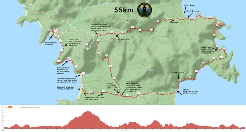
PRE RACE BRIEFING NOTES
 Please take the time to read these notes, as they are important to ensure you have a safe and enjoyable experience

THIS DOCUMENT IS BELIEVED TO BE ACCURATE , IF YOU NOTE ERRORS OR HAVE ANY CONCERNS PLEASE LET US KNOW

Welcome to the 2nd Run the Lighthouse - Wilsons Prom. This event offers
110km/115km – 55km, 21.1km – 6km distances. I hope you are all injury free
healthy and looking forward to the weekend and challenge ahead. Thank you to all
runners who are supporting this event. As always events that trailsplus conduct
support young people living with cancer this is done by contributions by Trailsplus
and voluntary donations runners can make at time of registration.

2021 see’s us with a small field limit size, At the time of writing this document we
have 50 entrants, mostly in the 21km and 55km events, There are currently 2 in
115km and 6 in the 6km.

We expect this to sell out next year as people will have more time to prepare and
schedule and hopefully things will be a little more normal for us all.

For those of us attending this will be a fun and supportive event in an awesome
location conducted in a very low key way. However,

                     MOST IMPORTANT
Unlike almost all of our events this one will have no course markings. While the
general flow of the course is on the main tracks that create a fig 8 shape on the
southern peninsula of the Prom. There are small tracks that may appear from time
to time, plus some of the camp grounds often have two or three paths to exit and
continue, so it’s important you have a clear understanding of the course and the
general direction it flows, so you enjoy your adventure.

Wilsons Prom is a beautiful part of Victoria’s Coastline, it contains small mountain
ranges that rise from the ocean to heights of 550M.

Don’t forget this is Victoria, weather is subject to change very quickly, come
prepared!

   PLEASE SPEND SOME TIME GETTING FAMILIAR WITH THE FOLLOWING INFORMATION

             WHAT YOU MUST DO IS PRINT YOUR MAP AND YOUR INSTRUCTIONS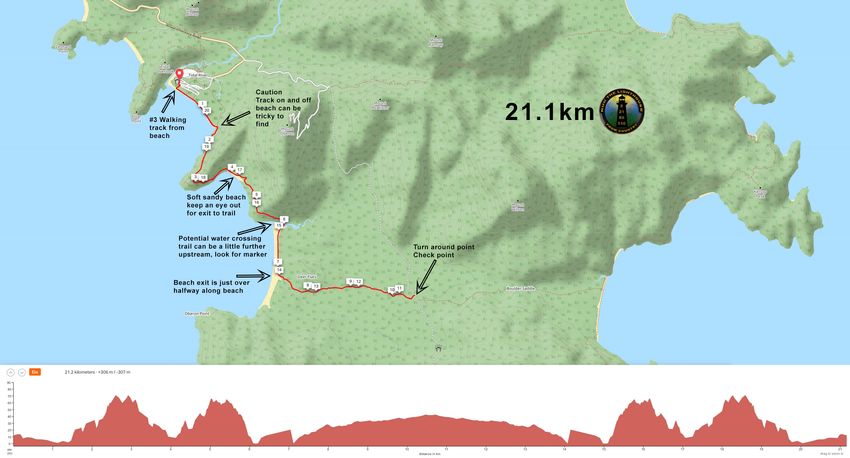
HIGHER QUALITY IMAGES WILL BE AVAILABLE ON WEBSITE

                        www.trailsplus.com.au/lighthouse go to maps tab

       TRACKING AND DIGITAL MAPS MAY BE IMPLEMENTED IN 2021

  The info below is from 2020 application, we are still finalising if a new
        system for 2021 can be used for 55km and 115km runners

Tracking your progress ( LIVE TRACKING ) and VIEWING
For safety and for watching your progress it is mandatory to have the TRACTALIS tracking app on
your phone, please ensure you use the following link and download the correct app for your type
of phone, Iphone or Android.

This link       https://live.tractalis.com/2020/lighthouse/default.html

Will take you to the live tracking site, there are 8 square icons to choose from, it’s very straight
forward, it looks like this, you can share the link with friends to watch your progress

Once you have the app loaded and present to us at check-in, we will then assign a key to your
phone to identify you on course. Please ensure the app is loaded we may not be able to load it
on site and it will delay the process of checking in.

Here are screen shots of the App Process, sample code shown only. You can prevent the two
grey screens appearing by making sure these settings are correct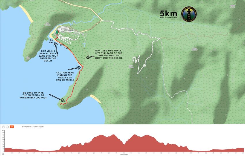
Screen 1.   Screen2.      Screen3.     Screen4.

PLEASE NOTE THE ABOVE APPLICATION INFO WILL CHANGE
FOR 2021, YOU MAY BE REQUIRED TO REGISTER YOUR
PHONE ON AN APP DURING CHECKIN ON SITE……………………..
WHAT IF YOU GO OFF COURSE
Please prepare yourself to have an enjoyable and safe journey on
the correct course, STUDY THE MAP recommended. By knowing
the course, you limit the risk of going wrong, however if this
occurs again.
HERE ARE OUR TIPS AND RULES

  •   REFER TO MAP IN PLASTIC BAG OR ON REAR OF BIB
  •   CARRY MAP AS REQUIRED IN MADATORY GEAR LIST
  •   LISTEN AND FOLLOW INSTRUCTIONS WHEN GIVEN
  •   DON’T JUST FOLLOW THE PERSON IN FRONT*
  •   *THE PERSON IN FRONT MIGHT BE IN A DIFFERENT RACE
  •   IF IN DOUBT ASK OR REFER TO YOUR MAP YOU PRINTED!
  •   THERE ARE NO TRAILSPLUS MARKINGS AT THIS EVENT
  •   WHEN ON A MAIN TRAIL STAY ON IT UNLESS THE MAP AND
      NOTES ADVISE OTHERWISE. THE PROM HAS WELL DEFINED
      TRAILS.
  •   REFER TO PRINTED INSTRUCTIONS IF NEEDED
         o IF YOU GO OF COURSE KNOWINGLY OR NOT
  •   FIRSTLY, GO BACK TO CORRECT COURSE AND CONTINUE
  •   IF YOU CAN’T, YOU WILL BE DISQUALIFIED
  •   IF YOU ARE FAST AND EXPECT TO PODIUM **
  •   **“KNOW THE COURSE”
  •   WE WILL NOT ACCEPT MAKE UP DISTANCES OFF COURSE
  •   MOST IMPORTANTLY – TAKE TIME TO STUDY MAPS, IT
      REALLY HELPS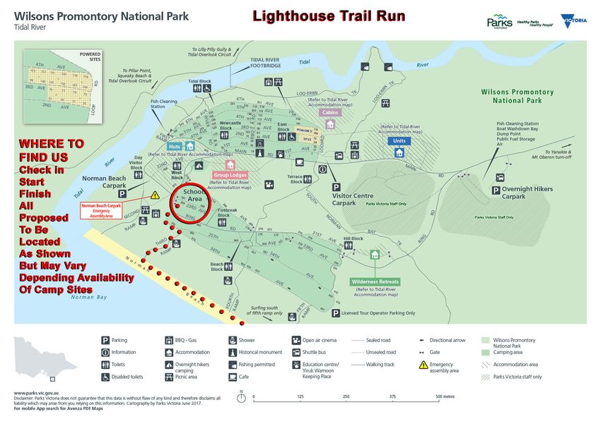
BRING WARM CLOTHES
                                  FOR BEFORE AND AFTER
                                            YOUR RACE
        WHERE REQUIRED ENSURE YOU HAVE FULL MANDATORY
                            GEAR

                                 NO EXCEPTIONS

                     LOOKING AFTER THE ENVIRONMENT
 We are proud and have had great success and positive feedback by eliminating paper cups and
making silicone cups available to buy along with several other environmentally friendly initiatives,
      please bring yours if you already have one, or bring your own reusable drink bottle.

                                      #goinggreener
     BUY a reusable, collapsible silicone cup $5 at registration
                       NO PAPER CUPS BEING PROVIDED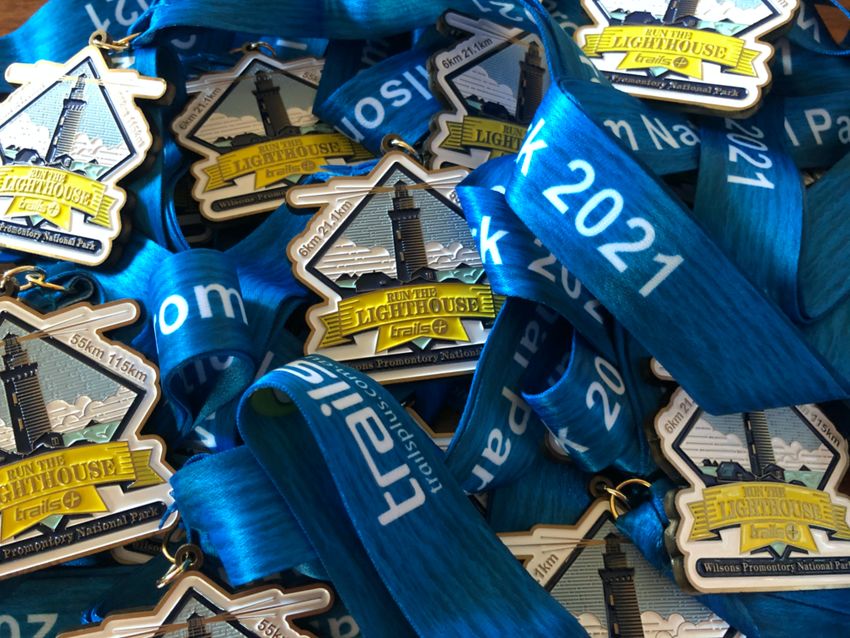
IMPORTANT INFORMATION
                               MANDATORY GEAR 2021
 Wilsons Prom can produce every imaginable weather condition
Therefore it is very important that the following mandatory gear as specified for each distance is
available on race day or carried as advised, no exceptions on race directors final decision.

   •   A side note on mandatory gear, as race organisers we often get questioned, why do I need
       to carry all of that gear. The simple answer is for your safety, we care, so should you. We are
       runners too, and we understand that in hindsight we carry a lot of gear that wasn’t needed
       during the event, but we think that is a great outcome, because if you needed it then there
       was possibly a worse outcome for you the runner during the event, so please except and
       understand, mandatory gear is mandatory, stay safe

   •   We generally have two levels of mandatory gear, in the form of light and heavy kit.

   •   Basically this means that the required full kit ( or heavy kit ) maybe reduced by a few items
       on race day, for example if deemed safe, you may not be required to carry overpants and
       thermal under garments.

   •   In addition to mandatory we have recommended lists sometimes, our mandatory list
       generally represents the minimum requirement, you can always add more items.

   •   HERE IS THE CURRENT FORECAST BUT LIKELY TO CHANGE A BIT BEFORE THE WEEKEND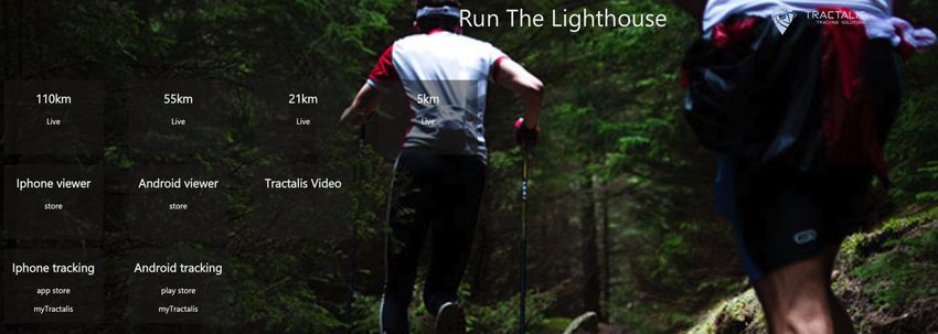
THE MANDATORY GEAR LIST
     110km                      55km                      21km                     5km

                       THE MANDATORY LIGHT KIT THAT MUST BE CARRIED WITHOUT FAIL

1    Smart Phone                Smart Phone               Smart Phone              Recommend Phone

2    Portable battery + lead    Portable battery + lead   n/a

3    1.5l water capacity        1.5l water capacity       500ml water capacity

4    Sealed Seam Weather        Sealed Seam Weather       Sealed Seam Weather
     proof jacket with hood     proof jacket with hood    proof jacket with hood

5    Space Blanket              Space Blanket             Space Blanket

6    Snake Bandage              Snake Bandage             Snake Bandage

7    Map Attached minimum       Map Attached minimum      Map Attached minimum

8    Plastic Bag for MAP        Plastic Bag for MAP       Plastic Bag for MAP

9    1000Kj Food                1000Kj Food               500Kj Food

10   Main Head Torch            Main Head Torch           n/a

11   Spare Head Torch           Spare Head Torch          n/a

12   Whistle                    Whistle                   Whistle

13   Extra Food Emergency       Extra Food Emergency      n/a

14

15

          THE MANDATORY HEAVY KIT THAT MUST BE AVAILABLE ONSITE FOR CHECKING IF NEEDED

16   Waterproof Pants           Waterproof Pants          Waterproof Pants

17   Thermal Top                Thermal Top               Thermal Top

18   Beanie + Gloves            Beanie + Gloves           Beanie + Gloves

19

20

                                       EVENT SCHEDULE
Check in takes place on Friday afternoon for the 55km and 110km runners. 21km and
5km runners can check in Saturday Morning, be sure to allow plenty of time to get
your gear checked 21km runners. You should arrive 60-90 minutes before start time
to get your gear checked off and your tracking ID key for your App you have on your
phone. 5km can arrive up to 30 minutes before the start.

      Event Schedule
      FRIDAY FEB 26th
      There are NO on day registrations
      15:00 - 20:00 Pre Race Gear Check in and Bib Collection at event hub, see map.
      SATURDAY FEB 27th
      06:30-6:50 - 110km Roll Call
      07:00 - 110km Start Race
      06:30-6:50 - 55km Roll Call
      07:00 - 55km Start Race
      09:00-9:50 - 21km Roll Call
      10:00 - 21km Start Race
      10:30-10:50 - 5km Roll Call
      11:00 - 5km Start Race

      Roll call is compulsory, if not checked off at roll call you can not start the event
      and are deemed a DNS and will not be considered a person of interest on
      course for safety and evacuation purposes.
      Roll call forms part of our pre race briefing, while the briefing will be
      abbreviated it will be highlighting some specific and significant aspects of the
      race safety requirements, course notes and conduct of participants. Race brief
      attendance is compulsory as part of Roll Call.
      Bibs and pre-ordered items will be collected at Friday or Saturday Check in.
      Uncollected items will be posted and a postage fee will be charged.

INSURANCE The event insurance policy does not extend to personal injury; it is highly
recommended that you have personal insurance cover or at least ambulance cover in
time for the event. If injured at Wilsons Prom you will likely need an air ambulance
and they can cost $10s of thousands of dollars if you are not covered

HERE IS A LINK TO AMBULANCE VICTORIA – BECOME A MEMBER
              THERE MAY BE SOME VARIATION AND LAST MINUTE CHANGES
    TO THE INFORMATION PROVIDED HERE SO PLEASE BE PREPARED FOR LATE UPDATES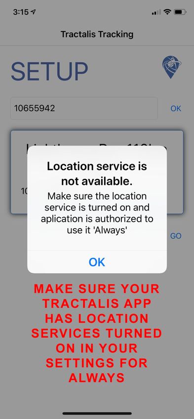
CUT OFF TIMES – we will always consider each person on their merit to assist in
finishing

Race cut off times, please note that 5km / 21km events do not have cut off time.

115km, it is expected the slowest runners can complete this course in under 26hrs
which is the official cutoff time, Sunday 8am. However we may cut you at
Telegraph track, 45km or Oberon/Telegraph Carpark at 94km if required for health
and safety reasons.

55km, it is expected the slowest runner can be at the Telegraph Junction before
4pm. This is the official cutoff time at the 45km mark, allowing you 10hrs, this
should see you finished by 8pm at the latest which is our official cutoff time, that’s
less than 4km /hr to do the course.

CHECK Point STATIONS
We have nominated 2 Check Point location for this course.

The check points maybe mobile in that they are there mid race but not later on,
likewise they may not have been there early but are there mid race.

CP1 – Telegraph Track Junction @10km – 45km – 100km

CP2 – Oberon Carpark @16km – 94km (optional for progress checking runners)

Check Point Aid Stations Open Times

Check Point 2 will be the first aid station visited by 115km and 55km runners
@16km. This check point will be operating between 8:30am and 10:00am or as last
runner passes through.

Check Point 2 may also be manned for the return leg of the 115km runners at
approx. 94-97km.

Check Point 1, is the turn around point for the 21.1km and the 45km mark for the
55km and 115km. This check point is expected to operate from 10:00am to 4:00pm
TOILETS
There are toilet blocks at various times on course including at the light house and
at the start finish campground and on course locations, a toilet is available approx.
8km in just as you exit Oberon beach, it is located off the trail to the right, equally
you pass back here at approx. 13km. Please ensure you use correct bush toilet
techniques all other times.

DROP BAGS
115km/55km Runners will be able to leave personal drop bags to be taken to check
point #1. These must be presented prior to our CP#1 Crew leaving. Soon after the
115km event starts Please note CP#1 will not be operational at your 10km mark. It
will be available from 44km (100m diversion to access maybe required pending
final setup location)

With the new start times 55km runners need to have their bags at the same time
as the 115km runners.

DROP BAGS must be no bigger than a typical shopping bag. Your Drop bag must be
named and clearly identifiable. Any drop bags or equipment not collected on race
or within 14 days will be sent to charity op shop or equivalent, unless items fit me
then I will keep them J.

IMPORTANT – drop bags will arrive back to the start finish area when the aid
stations are packed up, this may be after you want to leave.

YOUR MEDALS
               This year we have produced custom designed medals
COURSE NOTES AND MAPS
Camp Site – Start Finish
Where to find us in Tidal River Camp Ground
The event site hub will be set up in booked unpowered camping sites. Parks Vic policy does not
allow us to choose sites before arrival. Therefore, it is possible the planned location may not be
available. Please look around for us on your arrival, it will be located on or near where the map
indicates. It is not a very large area to walk around and find us. We may be able to place some
basic arrows to direct you, though we are sure you won’t have too much trouble.
IMPORTANT REMINDER AS WE TALK ABOUT THE COURSES
The Run the lighthouse courses are “UNMARKED” that means you need to have a map with you,
it means you should have already had a good look at the map to get a sense of where you are
going. This is a truly down to nature type event. So long as you have taken a little bit of time to
look over and read the information you will be perfectly fine. If after reading and you feel
concerned, always shout out and ask any questions, if you are still concerned, come and sit
around the camp with us and enjoy a relaxing couple of days.6km Your 6km course description Starting from the specified campground you will make your way through the campground and on to Norman Bay beach, via Walk Ramp #3. Turn left and head along the beach. At the end of the beach you exit via the soft sand up a short track then turn right and follow the only single track all the way to Norman Point Lookout (Don’t miss the turn off). Take extreme care on the final 300M single track to the look out, it is rough and rocky, also take extreme care near the end of the track, do not step out on rocks as there is no platform or safety barrier, you should turn at a point you are comfortable, once you have taken in the view Once you have gone to the lookout, taken a selfie or two, retrace your footsteps back to the start / finish area. Be sure to enter the beach and not go through the back of the Tidal River campground. You must finish along Norman Bay Beach, making sure you exit via #3 walking track ramp and up to the finish line.
21.1 km
Your 21.1km course description
Starting from the specified campground you will make your way through the
campground and on to Norman Bay beach, via Walk Ramp #3. Turn left and head
along the beach. At the end of the beach you exit via the soft sand up a short track
then turn right and follow the only single track. You will pass the Norman Point
lookout @3km, continuing on the only single trail until you reach little Oberon bay
@4km. Continue across the beach often in soft sand and navigating some large rocks
until you pick up the trail on the other side just before the end of the beach up to
your left. Continue on the single trail until Growlers creek water crossing @6km that
leads you onto Oberon Beach. Continue on Oberon beach until @7.5km, then exit
on to Oberon beach walking track for 3km until you reach the Telegraph track
junction @10.5km. This is your turn around point. Check in at the aid station (it
maybe just around the corner 50M to your RIGHT and not precisely on the junction)
grab some refreshments and retrace your steps back to the start finish.
55km
Your 55km course description
Starting from the specified campground you will make your way through the
campground and on to Norman Bay beach, via Walk Ramp #3. Turn left and head
along the beach. At the end of the beach you exit via the soft sand up a short track
then turn right and follow the only single track. You will pass the Norman Point
lookout, continuing on the only single trail until you reach little Oberon bay.
Continue across the beach often in soft sand and navigating some large rocks until
you pick up the trail on the other side just before the end of the beach up to your
left. Continue on the single trail until Growlers creek water crossing that leads you
onto Oberon Beach. Continue on Oberon beach @7km, then exit on to Oberon
beach walking track for 3km until you reach the Telegraph track junction @10km.
The check point allocated for here may not be active at the 10km distance but will
be there at 45km. Turn Left and head North up Telegraph track @16km where you
reach Telegraph track / Oberon carpark. There will be an aid station here. You will
turn right off telegraph track and head through the carpark and pick up the trail to
Windy Saddle and Sealers Cove @25km, turn right along the beach and cross the
sealers creek. Hug the coast trail around to Refuge Cove @31km. Take care finding
the trail out of refuge cove it can be a little tricky, basically keep to the coast side
and head around past Kersop Peak and on to North Waterloo bay @36km, continue
on to little Waterloo bay and Waterloo bay. @39km you drop down on to the beach
and cross freshwater creek if flowing. Take care now as you will turn off the main
beach around @40km mark, there is a trail along the grass edge of the beach or you
can take the beach to the exit ramp ( not always easy to see ). Now you are heading
for the finish. Heading west on Waterloo Bay walking track to Telegraph junction
@44km. Your Aid station will await you. You must do a right turn and then 100m
later turn left onto Oberon Bay walking track, continue for 3km to Oberon Bay
@47km, turn right on to the beach, continue for 2km, cross growler creek, track can
be a little hard to find, it is slightly up stream. Continue around to Little Oberon Bay
Beach @51km, cross the beach be careful navigating the rocks, look out for the trail
off the beach and head for the finish pass by Norman Bay Lookout @52km and
continue to the track that takes you back onto Norman Beach @53.5km. Don’t
continue in to back of campground, you must go along the beach. Continue for 1km
and exit on Ramp #3, follow the road to the start finish. Congratulations.
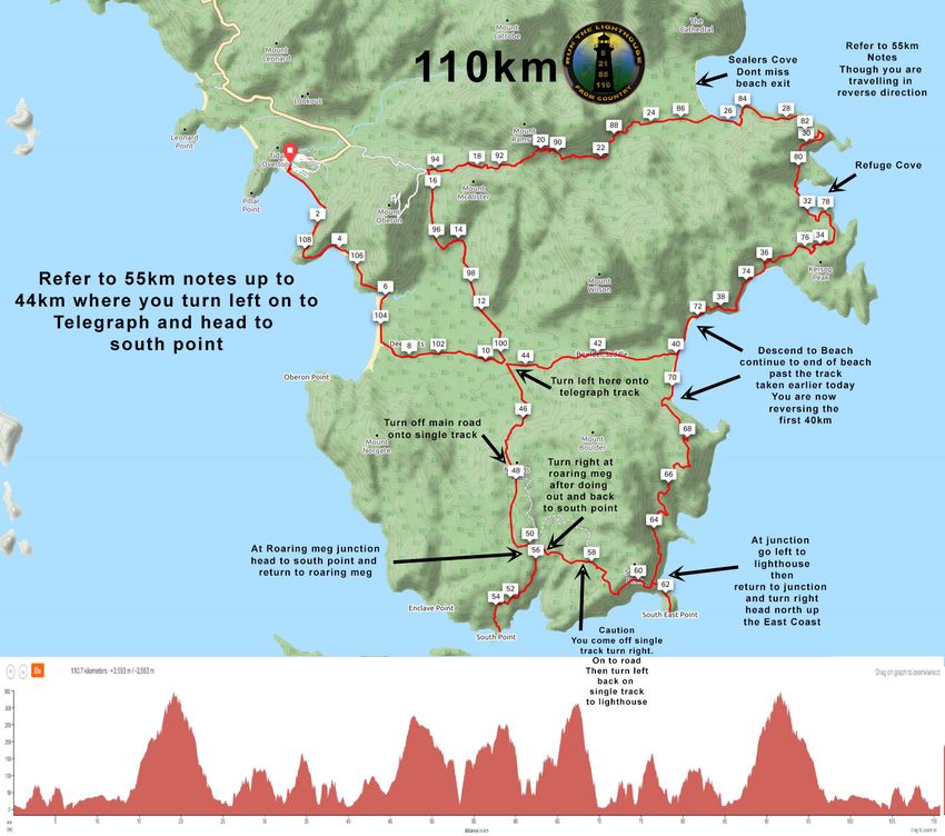
115km

Your 115km course description
Note the course may vary up to 5km on your GPS device, we have measure the course
based on 110km but actual onsite recorded data can extend to 115 km, therefore some
points may vary slightly.

Starting from the specified campground you will make your way through the campground
and on to Norman Bay beach, via Walk Ramp #3. Turn left and head along the beach. At
the end of the beach you exit via the soft sand up a short track then turn right and follow
the only single track. You will pass the Norman Point lookout, continuing on the only single
trail until you reach little Oberon bay. Continue across the beach often in soft sand and
navigating some large rocks until you pick up the trail on the other side just before the end
of the beach up to your left. Continue on the single trail until Growlers creek water crossing
that leads you onto Oberon Beach. Continue on Oberon beach @7km, then exit on to
Oberon beach walking track for 3km until you reach the Telegraph track junction @10km.
The check point allocated for here may not be active at the 10km distance but will be there
at 45km. Turn Left and head North up Telegraph track @16km where you reach Telegraph
track / Oberon carpark. There will be an aid station here. You will turn right off telegraph
track and head through the carpark and pick up the trail to Windy Saddle and Sealers Cove
@25km, turn right along the beach and cross the sealers creek. Hug the coast trail around
to Refuge Cove @31km. Take care finding the trail out of refuge cove it can be a little tricky,
basically keep to the coast side and head around past Kersop Peak and on to North
Waterloo bay @36km, continue on to little Waterloo bay and Waterloo bay. @39km you
drop down on to the beach and cross freshwater creek if flowing. Take care now as you
will turn off the main beach around @40km mark, there is a trail along the grass edge of
the beach or you can take the beach to the exit ramp ( not always easy to see ). Now you
are heading for the finish. Heading west on Waterloo Bay walking track to Telegraph
junction @44km. Your Aid station will await you. Turn left on telegraph track and continue
4km to the @47km mark where you will turn Right off the main telegraph track on to the
single walking track. Follow the walking track for 2km to roaring meg junction @49km. You
now do an out and back to roaring meg ( between @49km and @55km) when back at
roaring meg @55km turn right and follow single track until you meet main telegraph track
@57km then turn right and stay on telegraph track for 1km @58km turn left back on single
track and head for the lighthouse. @60km take track to the lighthouse, touch the
lighthouse door @61km, return to track junction @62km take right turn and follow single
track all the way to Waterloo Bay Beach@69km. Once on beach follow to the very end, do
not turn off like you did at the 40km mark as you are now doing the last 40km reverse of
what you did earlier. At the end of Waterloo bay cross freshwater creek @70km follow the
single track around to North Waterloo bay and up over kersop peak and descend into
refuge cove @77km. Continue on to sealers cover where you cross sealers creek @84km.
Once across the creek continue along beach for approx. 500M no more. Make sure you
exit the Sealers Cove beach ( YOU DO NOT GO TO THE END OF IT) follow the boardwalk
and single track all the way and to windy saddle and telegraph carpark. There may be an
aid station here possibly manned or unmanned. Go through the carpark and turn left down
telegraph track @94km. ( DO NOT GO DOWN MAIN ROAD ) Follow telegraph track to the
junction of Oberon bay walking track @100km. There may be an aid station here, but
depends on if crew met you at telegraph track carpark. Turn right toward Oberon Bay
beach, follow this track for 3km arrive at Oberon Bay beach @103km. Turn right on to the
beach, continue for 2km, cross growler creek @105km, track can be a little hard to find, it
is slightly up stream. Continue around to Little Oberon Bay Beach @106km, cross the beach
be careful navigating the rocks, look out for the trail off the beach and head for the finish
pass by Norman Bay Lookout @107km and continue to the track that takes you back onto
Norman Beach @109km. Don’t continue in to back of campground, you must go along the
beach. Continue for 1km and exit on Ramp #3, follow the road to the start finish. @110km
/115km Congratulations.
CONTINUED ACCESS AND THE FUTURE OF THIS EVENT

The future ability to hold this event depends totally on how we as a group conduct
ourselves. Parks Victoria do not guarantee we can continue to hold this event, but if we
are to have a chance of future trail events in this location it is important, we abide by a
series of guidelines. It only takes one member of the public to get upset and lodge a
complaint and the event may not be allowed to continue. Any rubbish found on course
can also reflect poorly on the event, these are just a couple of items to be aware of.
Courtesy and Common sense goes a long way and it is certainly what we know will be
shown by trail runners.

ALWAYS BE RESPECTFUL TO OTHER PARKS USERS AND GIVE THEM RIGHT OF WAY

Do not startle people by charging up behind them, let them know you are coming and
would like to pass, slow down when passing and when approaching from the opposite
direction. Always say hello and wish them a great day, it goes a long way.

Environment LEAVE NO TRACE Do Not Leave any sign of rubbish behind, it is very
important that we don’t drop rubbish or let rubbish get away from us at the aid stations.
In particular our Gel packets and tear off tabs, please don’t drop them on the trail carry
them with you to an aid station and drop in the bin provided. It is likely to be windy, please
try to keep aid station areas free from rubbish by using the bins.

All events will have pre race briefings to go over any questions you may have and to
provide me an opportunity to quickly cover what is required from us all on the day.

YOU MUST ATTEND THE BRIEFING OR WILL NOT BE PERMITTED TO START THE RACE

SAFETY It is requirement of entry to the event that you assist any runner in need of help,
if you come across an injured or distressed runner please offer assistance or get assistance
for them. Runner’s health and Safety is our number one priority. We will take into account
the time (in regard to cut-offs) you spend with a runner in need if you are then able to
continue on with the event and finish.

PERSONAL BELONGINGS An area will be provided for personal belongings however the
race director takes no responsibility for the safe keeping, if you intend to have valuables
please consider locking them in your car.

Check Points / Aid Stations When there are aid stations. The Aid Stations will be stocked
with a small amount of, Snakes, Chocolate, Fruit Cake, Chips, plenty of water and when
available sports drinks. Sometime Aid stations will also record your number and if possible
the time you came through so please ensure your number is always clear. If you believe
you are the last runner or close to last let the aid station know. REFER COVID SAFE PLAN
PHOTOGRAPHY

We often have our volunteer photographers here on the day to capture some great shots,
give them a smile and a wave. All aid stations are likely to have someone with a camera
also, try to look fresh J When time permits these photos are loaded for your access, we
don’t charge for photos and only invite donations to help with costs to make them available,
please be patient for thee to appear post event, it’s a long time consuming process.

PLACE GETTERS
We hopoe to have some trophies for the events and some small winners prizes if available
from sponsors, we are evaluating both the covid situation and handling and also the desire
to keep the Lighthouse run much more about the experience on course then the Bling at the
end ALL finishers will receive our custom designed medal

REGISTERED RUNNERS CHECKIN
All participants must chceckin on the morning and collect your race number, race numbers
to be visible at all times as this allows the aid station people to record that you have been
through and are accounted for, if we don’t have you marked off we will assume you are lost
and go looking for you, so please ensure you let them know your number and have been
acknowledged. In 2016 we had a runner unaccounted for and spent a long time trying to
track them down, they had gone home thankfully but we were close to implementing
search and rescues, so make sure if you pull out of the race and don’t come through the
finish line you let us know.

PARKS VICTORIA
We are extremely grateful for the wonderful work Parks Victoria does in keeping our parks
in great condition for us to enjoy. We appreciate the opportunity to stage a trail running
event out of Tidal River at Wilsons

RACE NUMBERS
We are planning manual electronic timing on our iPad or lap tops so please ensure your
number is visible and on the outside, if you have heavy jackets over them we may not
record you finish time. However if we have our red matt on the ground at the start finish
line it means we are using our full timing system and your race bib will have a timing chip
inserted in a pouch on the back, on completion of your event we will ask you to remove the
timing chip from the pouch and place in the container provided at the finish line.
You can also read