Screening for Appropriate Assessment - Temporary Construction Compound & Access Ramp
←
→
Page content transcription
If your browser does not render page correctly, please read the page content below
Screening for Appropriate Assessment

Temporary Construction Compound & Access Ramp

This page has been left intentionally blank
19983-6048-A               Screening for Appropriate Assessment           March 2021

ISSUE FORM
Project number         19983
Document number        6048
Document revision      A
Document title         Screening for Appropriate Assessment: Temporary Construction
                       Compound & Access Ramp
Document status        Client Issue
Document prepared by   AP, FMk, HD, JOL
Document checked by    OH (MWP 16/08/2019), HD (MWP – 02/09/2019), JOL 07/04/21

                                                                                   i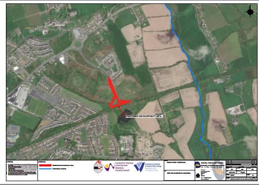
19983-6048-A                                           Screening for Appropriate Assessment                                                       March 2021

Table of contents
1.     SUMMARY OF FINDINGS ............................................................................................... 4
1.1          Screening for Appropriate Assessment ................................................................................. 4

2.     INTRODUCTION ............................................................................................................. 5
2.1          Purpose of Assessment ......................................................................................................... 5
2.2          Legislative Context ................................................................................................................ 5
2.3          Stages of Appropriate Assessment ........................................................................................ 5

3.     ASSESSMENT METHODOLOGY ...................................................................................... 6
3.1          Appropriate Assessment Guidance ....................................................................................... 6
3.2          Desk Study ............................................................................................................................ 6
3.3          Screening for Appropriate Assessment ................................................................................. 6

4.     SCREENING FOR APPROPRIATE ASSESSMENT ............................................................... 7
4.1          Management of Natura 2000 Sites ........................................................................................ 7
4.2          Description of Plan/Project ................................................................................................... 7
     4.2.1      Brief Project Description .................................................................................................................. 7
     4.2.2      Purpose of the Project ..................................................................................................................... 8
     4.2.3      Site Location .................................................................................................................................... 8
     4.2.4      Description of the Site ..................................................................................................................... 8
     4.2.5      Description of the Proposed Development ..................................................................................... 10
     4.2.6      Characteristics of the Project ......................................................................................................... 11
     4.2.7      Identification of Other Projects or Plans or Activities ...................................................................... 12

4.3          Identification of Natura 2000 Sites ...................................................................................... 13
     4.3.1      Zone of Impact Influence ............................................................................................................... 13
     4.3.2      Identification of Natura 2000 Sites ................................................................................................. 14
     4.3.3      Characteristics of Natura 2000 Sites ............................................................................................... 14
     4.3.4      Conservation Objectives ................................................................................................................ 16

4.4          Identification of Potential Impacts ...................................................................................... 17
4.5          Assessment of Significance of Potential Impacts ................................................................. 18
     4.5.1      Habitat Loss and Alteration ............................................................................................................ 20
     4.5.2      Water Quality ................................................................................................................................ 20
     4.5.3      Disturbance and/or Displacement of Species ................................................................................. 21
     4.5.4      Habitat or Species Fragmentation .................................................................................................. 21
     4.5.5      Cumulative/In-combination Impacts .............................................................................................. 21

4.6          Conclusion of Screening Stage ............................................................................................. 22

5.     REFERENCES ................................................................................................................ 23

                                                                                                                                                                  ii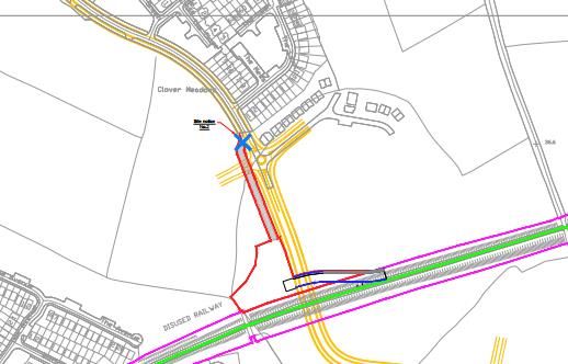
19983-6048-A                                  Screening for Appropriate Assessment                                         March 2021

Table of tables
Table 1: Characteristics of the Proposed Development ................................................................................... 11
Table 2: Designated Sites within 15km Radius of Proposal Site ....................................................................... 14
Table 3. Designated Site with Qualifying Feaures of Conservation Interest ...................................................... 14
Table 4: Theoretical Ecological Impacts Associated with the Project ............................................................... 17
Table 5: Likelihood of Significant Impacts on Conservation Objectives of Natura 2000 Sites ............................ 18

Table of figures
Figure 1:   Proposed Development Location at Abbeylands and Rathculliheen, Co. Kilkenny ............................... 7
Figure 2:   Proposed Development Location in Co. Kilkenny ............................................................................... 8
Figure 3:   Development Boundary and Ferrybank Stream to the east of the site .............................................. 10
Figure 4:   Natura 2000 sites within 15km of the Proposed Development ......................................................... 14

List of appendices
Appendix 1            Stages of Appropriate Assessment
Appendix 2            Site Synopses

                                                                                                                                        iii
19983-6048-A Screening for Appropriate Assessment March 2021
1. SUMMARY OF FINDINGS
1.1 Screening for Appropriate Assessment
Project Title AA Screening for Temporary Construction Compount and Access Ramp
associated with the South-East Greenway
Project Proponent Kilkenny County Council
Project Location Rathculiheen and Abbeylands, Co. Kilkenny
Screening for The Screening for Appropriate Assessment is undertaken to determine
Appropriate the potential for likely significant effects of the construction and
Assessment operation of the temporary construction compound and access ramp
individually, or in combination with other plans or projects, in view of the
conservation objectives of the site on a Natura 2000 Site.
Conclusion It has been objectively concluded during the screening process that the
four Natura 2000 sites listed below within 15km of the proposed
development are not likely to be significantly impacted by the
construction, operation and decommissioning of the proposed
development. The relevant Natura 2000 sites are:
The Lower River Suir SAC
The River Barrow and River Nore SAC
Tramore Backstrand SPA
Tramore Dunes and Backstrand SAC
419983-6048-A Screening for Appropriate Assessment March 2021
2. INTRODUCTION
2.1 Purpose of Assessment
This Screening for appropriate assessment has been undertaken to determine the potential for
significant impacts on a proposal to construct and operate a temporary construction compound and
access ramp associated with South East Greenway, in the town lands Rathculiheen and Abbeylands,
Co. Kilkenny, on nearby sites with European conservation designations (i.e. Natura 2000 Sites).
The Screening for appropriate assessment has been undertaken by Malachy Walsh and Partners
professional ecologists.
2.2 Legislative Context
The Habitats Directive (92/43/EEC) seeks to conserve natural habitats and of wild fauna and flora by
the designation of Special Areas of Conservation (SACs) and the Birds Directive (79/409/EEC) seeks
to protect birds of special importance by the designation of Special Protected Areas (SPAs). It is the
responsibility of each member state to designate SPAs and SACs, both of which will form part of
Natura 2000, a network of protected sites throughout the European Community. The Habitats
Directive has been transposed into Irish law and the relevant Regulations are the European
Communities (Birds and Natural Habitats) Regulations 2011. The requirement for Appropriate
Assessment of the implications of plans and projects on the Natura 2000 network of sites comes
from the Habitats Directive (Article 6(3)).
Under the European Communities (Birds and Natural Habitats) Regulations 2011, a public authority
is required to carry out Screening for appropriate assessment of a proposed development prior to
issuing consent to assess, in view of best scientific knowledge and the sites conservation objectives,
if that project or plan, individually or in combination with other plans or projects is likely to have a
significant effect on a Natura 2000 site. The information presented in this Screening for appropriate
assessment report will be used by the competent authority to assist them to complete their
screening exercise.
The Screening for appropriate assessment will determine whether an appropriate assessment of the
proposed development is required if it cannot be excluded, on the basis of objective information,
that the proposed development, individually or in combination with other plan or projects, will have
a significant effect on a Natura 2000 site. If it is determined that an appropriate assessment is
required in respect of the plan or proposed development, a Natura Impact Statement (NIS) must be
prepared. In the case of a proposed development that requires an appropriate assessment, the
application for consent must be accompanied by a NIS. The NIS will assist the competent authority
to conduct the appropriate assessment.
2.3 Stages of Appropriate Assessment
The appropriate assessment process is a four-stage process with tests at each stage. An important
aspect of the process is that the outcome at each successive stage determines whether a further
stage in the process is required. The stages are set out in Appendix 1.
519983-6048-A Screening for Appropriate Assessment March 2021
3. ASSESSMENT METHODOLOGY
3.1 Appropriate Assessment Guidance
This Screening for appropriate assessment has been undertaken in accordance with the European
Commission Methodological Guidance on the provision of Article 6(3) and 6(4) of the ‘Habitats’
Directive 92/43/EEC (EC, 2001), the European Commission Guidance ‘Managing Natura 2000 sites’
(EC, 2000) and guidance prepared by the NPWS (DoEHLG, 2009).
3.2 Desk Study
In order to complete the Screening for appropriate assessment, certain information on the existing
environment is required. A comprehensive desk study was carried out to collate available
information on the site’s natural environment. This comprised a review of the following publications,
data and datasets:
OSI Aerial photography and 1:50000 mapping, and other online mapping sources (online)
National Parks and Wildlife Service (NPWS) (online)
National Biodiversity Data Centre (NBDC) (online)
BirdWatch Ireland
Teagasc soil area maps (NBDC website)
Geological Survey Ireland (GSI) area maps (online)
Environmental Protection Agency (EPA) water quality data (online)
South Eastern River Basin District (SERBD) datasets (Water Framework Directive) (online)
Invasive Alien Species Management Plan – South East Greenway – MWP (2019)
Other information sources and reports footnoted in the course of the report
3.3 Screening for Appropriate Assessment
As set out in the NPWS guidance, the task of establishing whether a plan or project is likely to have
an effect on a Natura 2000 site(s) is based on a preliminary impact assessment using available
information and data, including that outlined above, and other available environmental information,
supplemented as necessary by local site information and ecological surveys. This is followed by a
determination of whether there is a risk that the effects identified could be significant. The
precautionary principle approach is required.
Once the potential impacts that may arise from the proposal are identified, the significance of these
is assessed through the use of key indicators:
Habitat loss and alteration
Disturbance and/or displacement of species
Habitat or species fragmentation
Water quality
619983-6048-A Screening for Appropriate Assessment March 2021
4. SCREENING FOR APPROPRIATE ASSESSMENT
Screening for appropriate assessment determines the need for a full appropriate assessment and
consists of a number of steps, each of which is addressed in the following sections of this report:
4.1 Establish whether the project is necessary for the management of a Natura 2000 site
4.2 Description of the Project (To construct and operate a temporary construction compound
and access ramp)
4.3 Identification of Natura 2000 sites potentially affected
4.4 Identification and description of individual and cumulative impacts of the project
4.5 Assessment of the significance of the impacts on the integrity of Natura 2000 sites
4.6 Conclusion of screening stage
4.1 Management of Natura 2000 Sites
The proposal is not connected with or necessary to the conservation management of a Natura 2000
site.
4.2 Description of Plan/Project
4.2.1 Brief Project Description
Kilkenny County council proposes to construct and operate a temporary construction compound
and access ramp to connect to the consented Southeast Greenway in the town lands of Rathculiheen
and Abbeylands, in Co. Kilkenny. The proposed construction compound will have an area of
3527m²with an access road of 594m2. The construction ramp has an area of 600m². The layout of
the proposed works is shown in Figure 1 below. The construction compound is accessed through the
existing Clover Meadows public road and links to the Greenway via a temporary access ramp running
to the east.
Figure 1: Proposed Development Location at Abbeylands and Rathculliheen, Co. Kilkenny Commented [A1]: Get new sketch from Frank Thorne
719983-6048-A Screening for Appropriate Assessment March 2021
4.2.2 Purpose of the Project
The purpose of the proposed development is to provide a temporary construction compound and
site access for contractors undertaking the development work on the new Greenway.
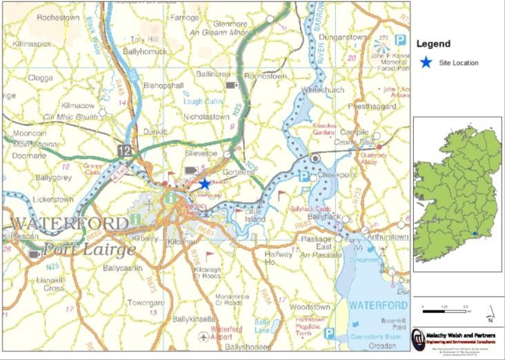
4.2.3 Site Location
The proposed development will be located in the town lands of Rathculiheen and Abbeylands in Co.
Kilkenny. The site is currently a Greenfield adjacent to the existing Clover Meadows Residential area.
The ITM coordinates for the centre point of the development are ITM: Easting 662360; Northing
613338. See Figure 2 below.
Figure 2: Proposed Development Location in Co. Kilkenny
4.2.4 Description of the Site
The circa 4.5ha proposal site is located approximately 2km east of Waterford City centre, 9km north
west of Passage East, and 18km south west of New Ross, Co. Wexford. According the central
Statistics Office, the proposed development spans over two “small areas”1. The eastern part and the
majority of the proposed development are within Small Area of: 097058010 which has a population
of 157 and the western part of the proposed development are within Small Area of: 097058013
which has a population of 248 according to the census in 20161.
The dominant habitat of the site is Improved Agricultural Grassland (GS1)2 and prior to 2005 the site
was managed. Between 2005 and 2012 residential housing and access roads (Buildings and Artificial
Surfaces BL3) were built to the north and west. These residential dwellings bound the part of the
site3. Adjacent lands to the east directly north of the site are managed agricultural lands. The site is
1 http://census.cso.ie/sapmap/
2 http://map.geohive.ie/mapviewer.html
3 https://goo.gl/maps/9EUujnhHGKt3BG518
819983-6048-A Screening for Appropriate Assessment March 2021
bounded to the south by the old disused railway which will form a section of the South East
Greenway. South of the railway there are additional agricultural lands. Boundaries of the site are
delineated by hedgerows to the east, west and south. To the north there is no clear boundary
between the existing Clover Meadows housing estate and the site.
The Bedrock at the site is made up of “Dark grey slate with thin siltstone” from the Palaeozoic,
Middle – Upper Ordovician. The soil type is deep well drained mineral soil. The 2018 Corine land
cover category for the proposed site is “Agricultural” in the southern part and “Artificial
surfaces/urban fabric” in the northern part4. The aquifer is described as “Regionally Important
Aquifer - Fissured bedrock” in the footprint of the proposed development and approximately 300m
north of the site along Clover Avenue road the aquifer is classed as “Poor Aquifer - Bedrock which is
Generally Unproductive except for Local Zones”4.
The proposed site is located within the South-eastern River Basin District and the Blackwater
(Kilmacow) sub-catchment (waterbody code: IE_SE_16L680750). This is a sub-catchment of the Suir
Catchment (Code 16) which is drained by the River Suir and all streams entering tidal water between
Drumdowney and Cheekpoint, Co. Waterford4. The site itself is not drained by any river/stream.
There is one small 1st order stream located approximately 550m to the east of the eastern boundary
of the proposed development (Ferrybank 16 Stream, EPA Code: 16F425). This stream discharges into
the Lower River Suir SAC approximately 1.5km south of this point, see Figure 3, below. The stream
itself does not form part of the SAC. There are no hydrological links between the development
footprint of the development and any Natura 2000 site.
4 https://gis.epa.ie/EPAMaps/
5 https://gis.epa.ie/EPAMaps/
919983-6048-A Screening for Appropriate Assessment March 2021
Figure 3: Development Boundary and Ferrybank Stream to the east of the site Commented [A2]: Update sketch
4.2.5 Description of the Proposed Development
The development will be located south of the existing Clover Meadows housing estate on an existing
green field. The following gives details for the works:
Access Road
Area 594m²
Imported Hardcore 280m³
Temporary Perimeter Fencing
Compound
Area 3527m²
Imported Hardcore 1500m³
Temporary Perimeter Fencing
Temporary Contractor Cabins, self contained toilet facilities.
Site Lighting
Access Ramp
Area 600m2
Imported Gabion Baskets
Imported Hardcore 650m³
1019983-6048-A Screening for Appropriate Assessment March 2021
The proposed development will be constructed at ground level with the ramp providing a sloped
connection to the Greenway itself. The finishes on all surfaces will be free draining in hardcore thus
allowing the existing drainage regimen to be maintained.
4.2.6 Characteristics of the Project
The proposal is described below in Table 1 and has been confirmed with the project design
engineering team.
Table 1: Characteristics of the Proposed Development
Size, scale, area, land-take There is no spatial overlap between the proposal site and any Natura 2000
site(s). There is no hydrological connection between the proposal site and any
Natura 2000 site.
Details of physical changes The construction of thedevelopment will involve the excavation of topsoil to
that will take place during circa 0.3m bGL to facilitate the installation of a geotextile and granular base for
the various stages of the compound surface. All excavated material will be from clean, natural
implementing the proposal Greenfield.
It is proposed to retain clean excavated materials (topsoil/subsoil/rock) on-site
for re-use as berms, raised planting areas, and general landscaping. The
proposed compound and access road boundary will incorporate stock-proof
temporary Herras fencing.
The access ramp will be formed with gabion baskets retaining the hardcore
filled ramp. Herras fencing will provide boundary definition.
The compound will contain the temporary contractor cabins and facilities.
Description of resource Construction materials and quantities to be used in the proposed development
requirements for the are as follows (approximate quantities):
construction/operation and
decommissioning of the
proposal (water resources, Access Road
construction material,
human presence etc) Area 594m²
Imported Hardcore 280m³
Temporary Perimeter Fencing
Compound
Area 3527m²
Imported Hardcore 1500m³
Temporary Perimeter Fencing
Temporary Contractor Cabins, self contained toilet facilities.
Site Lighting
1119983-6048-A Screening for Appropriate Assessment March 2021
Access Ramp
Area 600m2
Imported Gabion Baskets
Imported Hardcore 650m³
Description of timescale for
the various activities that
will take place as a result of It is anticipated that the proposed works will take 1 month to complete.
implementation (including
likely start and finish date)
Description of wastes It is envisaged that excavated topsoil from the development will be reused
arising and other residues onsite for the construction of, and planting to berms, traffic islands, and
(including quantities) and perimeter beds.
their disposal
All excavation materials/wastes arising from the proposed development works
are to be minimised by strict control and where not reused are to be removed
from site by authorised contractors and either reused under Article 27
notifications or disposed of at a suitably licensed facility off-site.
Fuels/oils.
Wastewater/effluent from temporary toilet facilities.
Identification of wastes No wastes arising are of particular concern in the context of Natura 2000 sites.
arising and other residues
(including quantities) that No hazardous waste material is envisaged from the proposal
may be of particular Incidental waste materials such as pallets and packaging will be
concern in the context of separated accordingly prior to disposal
the Natura 2000 network Waste will be minimised by strict control and planning of materials
received
All wastes generated during the construction phase will be manged as part of
the Waste Management Plan included in the contractors CEMP.
During construction waste from the portable toilet will be collected and
disposed of off-site by a licensed contractor.
Refuelling will take place within a dedicated, hard-surface area which will be
lined and bunded with polythene and stone. Fuel will be stored in a secure,
impermeable storage area, away from drains and open water. A fuel
management plan will be put in place for the duration of the works.
Description of any
additional services required
to implement the project or No additional services are required to implement the project.
plan, their location and
means of construction
4.2.7 Identification of Other Projects or Plans or Activities
The proposal was considered in combination with other plans and projects in the area that could
result in cumulative impacts on Natura 2000 sites. Other plans considered include:
Ferrybank Belview Local Area Plan 2017;
Kilkenny County Development Plan (2014 – 2020);
1219983-6048-A Screening for Appropriate Assessment March 2021
South East River Basin District River Basin Management Plan (2009-2015)
Each of these plans has a range of environmental and natural heritage policy safeguards in place.
These safeguards to protect the natural environment and Natura 2000 sites will also apply to the
proposal described in this report. The primary land-use in the area extending away to the northeast
(Clover Meadows) and west is residential, while land-use to the north, east, and south is primarily
agricultural. The Ferrybank-Belview Local Area Plan has zoned the environs around the proposed
development for residential development and as a ‘strategic reserve’ for future land-use.
As such, the level of agricultural activity is likely to be sustained at current levels, throughout the
construction and operational phases of the proposal, constraints on the extent and type of
developments that are, or will be, permitted are imposed by the Ferrybank-Belview Local Area Plan
(2017) which indicates that the amount of development that will occur within the environs of the
subject site are limited to lands zoned for residential development.
Facilities operating with IPPC licences within the local area consist of Anglo Beef Processors Ireland
Unlimited Company t/a ABP Proteins Waterford located approximately 1.1km southwest of the
proposed development and Glanbia Ireland (Belview) Kilkenny located approximately 2.3km
southeast of the development5. Waterford City Urban Wastewater treatment plant (UWW) is the
closest wastewater facility and is located approximately 2.3km southwest of the proposed
development5.
Therefore, it is considered that agriculture and permitted/proposed development within the
environs of the proposal site comprise the main activities with which the proposed development
could potentially interact synergistically to create cumulative or in-combination impacts. While it is
not foreseen that any of the projects or plans discussed above will result in significant cumulative
impacts on any of the Natura 2000 sites in combination with the proposal the potential for
significant cumulative or in-combination impacts is discussed in Section 4.5.5 below.
4.3 Identification of Natura 2000 Sites
4.3.1 Zone of Impact Influence
The screening stage of AA involves compiling a ‘long list’ of European sites within a zone of potential
impact influence for later analysis which may or may ultimately not be significantly impacted upon
by the proposal. All Natura 2000 sites within 15km of the proposal location will be characterised in
the context of the rationale for designation and qualifying features, in accordance with NPWS
guidance. In line with the precautionary principle, during the preparation of this report Natura 2000
sites that lie outside 15km that may be significantly impacted as a result of the proposed works were
also considered. Following this, the potential impacts associated with the proposal will be identified
before an assessment is made of the likely significance of these impacts.
As described above, the test for the screening for appropriate assessment is to assess, in view of
best scientific knowledge, if the development, individually or in combination with other plan/project
is likely to have a significant affect on a Nature 2000 site. If there are any significant, potentially
significant, or uncertain effects, it will be necessary to proceed to appropriate assessment and
submit an NIS.
1319983-6048-A Screening for Appropriate Assessment March 2021
4.3.2 Identification of Natura 2000 Sites
Adopting the precautionary principle in identifying potentially affected European sites, it has been
decided to include all SACs and SPAs, within a 15km radius of the proposal site. Table 2 below lists
designated SACs and SPA within 15km or the anticipated zone of influence of the proposal site
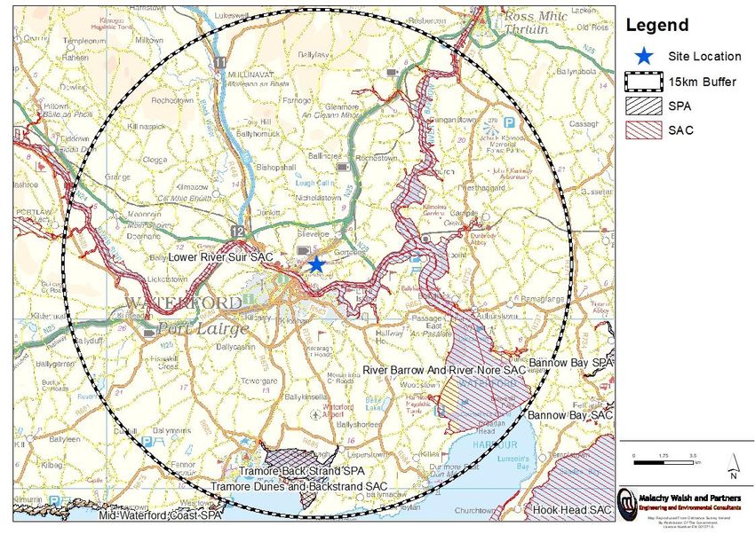
including their proximity. Figure 4 below shows all Natura 2000 sites within 15km of the proposal.
Table 2: Designated Sites within 15km Radius of Proposal Site
No. Designated Site Site Code Proximity of site to nearest point of designated site
1 Lower River Suir SAC 002137 Approximately 1.2km south west
2 River Barrow and River Nore SAC 002162 Approximately 5.2km east
3 Tramore Backstrand SPA 004027 Approximately 10.5km south
4 Tramore Dunes and Backstrand SAC 000671 Approximately 10.5km south
Figure 4: Natura 2000 sites within 15km of the Proposed Development
4.3.3 Characteristics of Natura 2000 Sites
Table 3 below lists the features of interest for the SACs and SPAs sites that lie within 15km of the
proposal site, as identified in Table 2. Information pertaining to designated sites is from site
synopses, conservation objectives and other information available on www.npws.ie.
Table 3. Designated Site with Qualifying Features of Conservation Interest
Designated
Qualifying features of conservation interest
Site
Lower River - Atlantic salt meadows (Glauco-Puccinellietalia To maintain or restore the favourable
1419983-6048-A Screening for Appropriate Assessment March 2021
Designated
Qualifying features of conservation interest
Site
Suir SAC maritimae) [1330] conservation condition of the Annex I
(002137) - Mediterranean salt meadows (Juncetalia habitats listed as Qualifying Interests
maritimi) [1410] for this SAC.
- Water courses of plain to montane levels with
the Ranunculion fluitantis and Callitricho- To maintain or restore the favourable
Batrachion vegetation [3260] conservation condition of the species
- Hydrophilous tall herb fringe communities of listed as Qualifying Interests for this
plains and of the montane to alpine levels SAC.
[6430]
- Old sessile oak woods with Ilex and Blechnum
in the British Isles [91A0]
- Alluvial forests with Alnus glutinosa and
Fraxinus excelsior (Alno-Padion, Alnion
incanae, Salicion albae) [91E0]
- Taxus baccata woods of the British Isles [91J0]
- Margaritifera margaritifera (Freshwater Pearl
Mussel) [1029]
- Austropotamobius pallipes (White-clawed
Crayfish) [1092]
- Petromyzon marinus (Sea Lamprey) [1095]
- Lampetra planeri (Brook Lamprey) [1096]
- Lampetra fluviatilis (River Lamprey) [1099]
- Alosa fallax fallax (Twaite Shad) [1103]
- Salmo salar (Salmon) [1106]
- Lutra lutra (Otter) [1355]
River Barrow - Estuaries [1130] To maintain or restore the favourable
and River Nore - Mudflats and sandflats not covered by conservation condition of the Annex I
SAC (002162) seawater at low tide [1140] habitats listed as Qualifying Interests
- Reefs [1170] for this SAC.
- Salicornia and other annuals colonising mud
and sand [1310] To maintain or restore the favourable
- Atlantic salt meadows (Glauco-Puccinellietalia conservation condition of the species
maritimae) [1330] listed as Qualifying Interests for this
- Mediterranean salt meadows (Juncetalia SAC.
maritimi) [1410]
- Water courses of plain to montane levels with
the Ranunculion fluitantis and Callitricho-
Batrachion vegetation [3260]
- European dry heaths [4030]
- Hydrophilous tall herb fringe communities of
plains and of the montane to alpine levels
[6430]
- Petrifying springs with tufa formation
(Cratoneurion) [7220]
- Old sessile oak woods with Ilex and Blechnum
in the British Isles [91A0]
- Alluvial forests with Alnus glutinosa and
1519983-6048-A Screening for Appropriate Assessment March 2021
Designated
Qualifying features of conservation interest
Site
Fraxinus excelsior (Alno-Padion, Alnion
incanae, Salicion albae) [91E0]
- Vertigo moulinsiana (Desmoulin's Whorl Snail)
[1016]
- Margaritifera margaritifera (Freshwater Pearl
Mussel) [1029]
- Austropotamobius pallipes (White-clawed
Crayfish) [1092]
- Petromyzon marinus (Sea Lamprey) [1095]
- Lampetra planeri (Brook Lamprey) [1096]
- Lampetra fluviatilis (River Lamprey) [1099]
- Alosa fallax fallax (Twaite Shad) [1103]
- Salmo salar (Salmon) [1106]
- Lutra lutra (Otter) [1355]
- Trichomanes speciosum (Killarney Fern) [1421]
- Margaritifera durrovensis (Nore Pearl Mussel)
[1990]
Tramore - Light-bellied Brent Goose (Branta bernicla To maintain or restore the favourable
Backstrand SPA hrota) [A046] conservation condition of the bird
(004027) - Golden Plover (Pluvialis apricaria) [A140] species listed as Special Conservation
- Grey Plover (Pluvialis squatarola) [A141] Interests for this SPA.
- Lapwing (Vanellus vanellus) [A142]
- Dunlin (Calidris alpina) [A149]
- Black-tailed Godwit (Limosa limosa) [A156]
- Bar-tailed Godwit (Limosa lapponica) [A157]
- Curlew (Numenius arquata) [A160]
- Wetland and Waterbirds [A999]
Tramore Dunes - Mudflats and sandflats not covered by To maintain or restore the favourable
and Backstrand seawater at low tide [1140] conservation condition of the Annex I
SAC (000671) - Annual vegetation of drift lines [1210] habitats listed as Qualifying Interests
- Perennial vegetation of stony banks [1220] for this SAC.
- Salicornia and other annuals colonising mud
and sand [1310] To maintain or restore the favourable
- Atlantic salt meadows (Glauco-Puccinellietalia conservation condition of the species
maritimae) [1330] listed as Qualifying Interests for this
- Mediterranean salt meadows (Juncetalia SAC.
maritimi) [1410]
- Embryonic shifting dunes [2110]
- Shifting dunes along the shoreline with
Ammophila arenaria (white dunes) [2120]
- Fixed coastal dunes with herbaceous
vegetation (grey dunes) [2130]
* indicates a priority habitat under the Habitats Directive
4.3.4 Conservation Objectives
According to the Habitat’s Directive, the conservation status of a natural habitat will be taken as
‘favourable’ within its biogeographic range when:
1619983-6048-A Screening for Appropriate Assessment March 2021
its natural range and areas it covers within that range are stable or increasing, and
the specific structure and functions which are necessary for its long-term maintenance exist
and are likely to continue to exist for the foreseeable future, and
the conservation status of its typical species is favourable as defined below.
According to the Habitats Directive, the conservation status of a species means the sum of the
influences acting on the species concerned that may affect the long-term distribution and
abundance of its populations. The conservation status will be taken as ’favourable’ within its
biogeographic range when:
population dynamics data on the species concerned indicate that it is maintaining itself on a
long-term basis as a viable component of its natural habitats, and
the natural range of the species is neither being reduced nor is likely to be reduced for the
foreseeable future, and
There is, and will probably continue to be, a sufficiently large habitat to maintain its
populations on a long-term basis.
The specific conservation objectives for each site are available on www.npws.ie. These have been
accessed for the sites listed in the tables above on the 25th July 2019.
Site specific and more detailed conservation objectives were available for the following sites:
Lower River Suir SAC (002137). Produce March 2017, Version 1.
River Barrow and River Nore SAC (002162). Produced July 2011, Version 1.
Tramore Backstrand SPA (004027). Produced October 2013, Version 1.
Tramore Dunes and Backstrand SAC (000671). Produced September 2013, Version 1.
Management plans were not available for any sites. All conservation objectives together with other
designated site information are available on http://www.npws.ie/protectedsites/.
4.4 Identification of Potential Impacts
In this section potential theoretical impacts associated with the proposed development will be
identified before an assessment is made, in Section 4.5, as to whether these theoretical impacts are
likely to cause significant impacts on the Natura 2000 sites listed in Table 4 below, in view of those
sites’ conservation objectives.
Identification of a theoretical risk does not constitute a prediction either that it will occur, or that it
will cause or create an adverse impact. However, identification of the risk does mean that there is a
possibility of ecological or environmental damage occurring, with the level and significance of the
impact depending upon the nature and exposure to the risk and the characteristics of the receptor.
Table 4: Theoretical Ecological Impacts Associated with the Project
Description of elements of the project - Run-off from the site e.g. sediment
likely to give rise to potential ecological - Excavation works
impacts sites. - Use of construction equipment, vehicles, and plant
- Construction works, use of fuels, oils, lubricants, concrete, etc
1719983-6048-A Screening for Appropriate Assessment March 2021
Describe any likely direct, indirect or In general, construction works associated with the project have
secondary ecological impacts of the the potential to result in the following impacts:
project (either alone or in combination
with other plans or projects) by virtue of: - Surface run-off of sediments/fines to watercourses
- Ingress of uncured cementitious material/concrete
Size and scale; wastewater, fuels or oils to watercourses
Land-take; - Species disturbance/displacement impacts
Distance from Natura 2000 Site or
key features of the Site; However, the risk of these impacts occurring is considered low by
Resource requirements; virtue of the intervening distance and lack of impact pathways
Emissions; between the proposal site and any Natura 2000 sites. The nearest
Excavation requirements; Natura 2000 site (Lower River Suir SAC) is located approximately
Transportation requirements; 1.2km to the south.
Duration of construction, operation
etc.; and The primary emissions expected from the proposed development
Other. are fugitive emissions of noise from use of plant/machinery and
excavation works during the construction phase, as well the
increase in human activity for the duration of the works.
4.5 Assessment of Significance of Potential Impacts
This section considers the list of Natura 2000 sites identified in Section 4.3.2 above, together with
the potential ecological impacts identified in the previous section, and determines whether the
proposed development is likely to have significant effects on any Natura 2000 sites in view of the
sites’ conservation objectives.
When assessing impact, qualifying features of conservation interest are only considered relevant
where a credible or tangible source-pathway-receptor link exists between the proposed
development and special conservation interest species or habitat. In order for an impact to occur
there must be a risk initiated by having a 'source' (e.g. construction works), a 'receptor' (e.g. a
protected species, associated aquatic or riparian habitats), and
an impact pathway between the source and the receptor (e.g. a watercourse which connects the
proposed development site to the site designated for the protection of a species).
An initial assessment is made below to determine what sites within the potential zone of impact
influence, as identified in Table 1, above, can be considered to be outside the functional zone of
impact influence, based on the potential ecological impacts identified in Section 4.4 above. This
initial assessment takes cognisance of the scope, scale and nature of the project, its location relative
to the Natura 2000 sites, the sensitivity of the ecological receptors, and the degree of connectedness
that exists between the project and each Natura 2000 site’s qualifying features.
Table 5: Likelihood of Significant Impacts on Conservation Objectives of Natura 2000 Sites
Proximity of Natura Likelihood of
Natura 2000 Site 2000 site to subject Significant Rationale
site Impact
River Barrow Approximately 5.2km No – Distance intervening provides a buffer
and River Nore east of the subject between impact sources and this Natura
SAC (002162) site 2000 site.
1819983-6048-A Screening for Appropriate Assessment March 2021
Proximity of Natura Likelihood of
Natura 2000 Site 2000 site to subject Significant Rationale
site Impact
– No direct ecological or hydrological
pathways linking the Natura site with the
subject site.
The ecology of the Annexed habitats and QI
species in question are neither structurally,
nor, functionally linked to the subject site.
– Significant impacts are not reasonably
foreseeable.
Tramore Approximately No – Distance intervening provides a buffer
Backstrand SPA 10.5km south of the between impact sources and this Natura
(004027) subject site 2000 site
– Due to the ecological characteristics,
requirements & specialities of the SCI
species they are restricted in their
distribution to habitats not present at, or
adjacent to, the subject site and all of the SCI
species are either intertidal, or sheltered &
shallow subtidal mud and sand flat feeders
(NPWS, 2013).
The resident populations of the SCI species
for which this site is designated are expected
to preferentially select the high-quality
habitats that are abundantly available within
the SPA designated for their protection.
– No hydrological link between the subject site
and the SPA.
– No direct ecological pathways linking the
Natura site with the subject site.
– The ecology of the habitat complex in
question are neither structurally, nor,
functionally linked to the subject site.
– Significant impacts are not reasonably
foreseeable.
Tramore Dunes Approximately No – No hydrological link between the subject site
and Backstrand 10.5km south of the and the SAC.
SAC (00071) subject site – Distance intervening provides a buffer
between impact sources and this Natura
2000 site.
– No direct ecological pathways linking the
Natura site with the subject site.
The ecology of the Annexed habitats in
question are neither structurally, nor,
functionally linked to the subject site.
– Significant impacts are not reasonably
foreseeable.
1919983-6048-A Screening for Appropriate Assessment March 2021
Due to the absence of a plausible impact pathway connecting certain designated sites to the location
of the proposed works, and/or in the absence of potential ecological receptors, such sites are
considered to be outside the functional zone of impact influence of the proposal. Therefore, it is
objectively concluded that the proposal does not include any element likely to result in significant
effects on the conservation objectives of the Natura 2000 sites outlined in the table above.
It is considered that the proposed development has some, albeit limited, potential to affect some of
the qualifying features of the remaining Natura 2000 site identified as being within the functional
zone of impact influence, namely the Lower River Suir SAC (002137). Therefore, the assessment of
significance of potential effects focuses on this designated site.
The likelihood of significant effects from the project was determined based on a number of
indicators including:
Habitat loss
Habitat alteration
Habitat or species fragmentation
Disturbance and/or displacement of species
Water quality and resource
The likelihood of significant cumulative/in-combination effects is assessed in Section 4.5.5.
4.5.1 Habitat Loss and Alteration
There is no physical overlap between the subject site and the Lower River Suir SAC, nor is there any
hydrological connection between the proposed area of works and the SAC. Therefore, it can be
objectively concluded that there will be no direct/indirect loss or alteration of habitats within the
Lower River Suir SAC, as a result of the proposal considered in this report.
4.5.2 Water Quality
There are no watercourses draining the subject area. The closest watercourse to the proposal site,
which eventually drains to the Lower River Suir SAC, is a small 1st order stream (Ferrybank Stream)
located approximately 550m to the east of the eastern boundary of the proposed development. This
stream discharges into the Lower River Suir SAC approximately 1.5km south of this point. The
intervening stretch of ground between the proposal site boundary and this stream comprises
vegetated land which further acts as a buffer between the proposal area of works and the
watercourse.
In summary, there is no hydrological connection between the proposal site and the Lower River Suir
SAC. Therefore, significant water quality impacts are not likely within the Lower River Suir SAC or the
Ferrybank Stream, as a result of the proposal considered in this report.
2019983-6048-A Screening for Appropriate Assessment March 2021
4.5.3 Disturbance and/or Displacement of Species
The Lower River Suir SAC is designated for a range of aquatic species including freshwater pearl
mussel, white-clawed crayfish, the three species of lamprey, twaite shad and Atlantic salmon. With
regards to the potential for indirect disturbance/displacement impacts to these qualifying features it
has been determined in the previous section that significant water quality impacts as a result of the
proposal are not envisaged.
The Lower River Suir SAC is also designated for otter. Otters are found in a variety of aquatic habitats
in Ireland such as lakes, rivers, streams, estuaries, marshland, and canals and along the coast. Otters
have a widespread distribution in Ireland and could potentially use the Ferrybank Stream which is
located to the east of the site and which drains to the SAC.
With regards to the potential for disturbance/displacement impacts to otter, it is considered that
any increase in noise emissions associated with the works will be temporary, intermittent and will be
restricted to normal working hours. The proposed site is situated in an urban area, and as such any
otters that may occur in the greater area are likely to be accustomed to some level of anthropogenic
disturbance. The intervening distance between the proposed area of works and the Ferrybank
Stream (approx. 500m) is considered sufficient to negate any potential for significant
disturbance/displacement impacts during either construction or operational phase.
It is objectively concluded that significant disturbance/displacement impacts to any of the qualifying
interest species for the Lower River Suir SAC are not likely to occur, as a result of the proposal
considered in this report.
4.5.4 Habitat or Species Fragmentation
Habitat fragmentation has been defined as ‘reduction and isolation of patches of natural
environment’ (Hall et al., 1997 cited in Franklin et al., 2002) which results in spatial separation of
habitat areas which had previously been in a state of greater continuity. Adverse effects of habitat
fragmentation on species include the increased isolation of populations which can detrimentally
impact on the resilience or robustness of the populations.
The preceding sections have concluded that significant habitat loss/alteration within the Lower River
Suir SAC is not predicted and significant disturbance or displacement of any of the qualifying interest
species is not expected to ensue. Having regard to the scale of the project, and its localised nature,
being restricted to modified habitat, situated on the urban fringe of Waterford, and the conclusions
of the preceding sections, it is considered that significant habitat or species fragmentation impacts
are not reasonably foreseeable as a result of the proposal considered in this report.
4.5.5 Cumulative/In-combination Impacts
As well as singular effects, the potential for in-combination or cumulative impacts also need to be
considered. A cumulative impact arises from incremental changes caused by past, present and
proposed projects together with the proposed development considered in this document. Relevant
plans and projects have been identified in Section 4.2.7 above.
The preceding sections, Sections 4.5.1 to 4.5.4 above, have concluded that significant habitat loss or
alteration impacts within the Lower River Suir SAC are not foreseen, no significant water quality
2119983-6048-A Screening for Appropriate Assessment March 2021
impacts are predicted, and significant disturbance/displacement or habitat/species fragmentation
impacts on any of the qualifying interest features for the SAC are not expected to arise.
Having regard to these conclusions it is considered that significant synergistic interaction between
the proposal, as described in Section 4.2.6 above, and any of the activities outlined in Section 4.2.7
above, that could create adverse cumulative or in-combination impacts on the conservation
objectives of the SAC, is not reasonably foreseeable. Therefore, it is objectively concluded that
significant cumulative or in-combination impacts on the Lower River Suir SAC (002137) are not likely,
as a result of the proposal considered in this report.
4.6 Conclusion of Screening Stage
The Screening for appropriate assessment is undertaken to determine the potential for likely
significant effects of a proposed temporary compound, access road and Greenway access ramp
associated with the Southeast Greenway, individually, or in combination with other plans or
projects, in view of the conservation objectives of the site on Natura 2000 Sites.
The proposed development is within 15km of four Natura 2000 sites. It has been objectively
concluded that the following sites are not likely to be significantly affected by the proposal and can
therefore be screened out for appropriate assessment:
The Lower River Suir SAC (002137)
The River Barrow and River Nore SAC (002162)
Tramore Backstrand SPA (004027)
Tramore Dunes and Backstrand SAC (000671)
2219983-6048-A Screening for Appropriate Assessment March 2021
5. REFERENCES
DoEHLG, 2009. Appropriate Assessment of Plans and Projects in Ireland: Guidance for Planning
Authorities. Department of Environment, Heritage and Local Government.
EC (2000). Managing Natura 2000 Sites: The provisions of Article 6 of the ‘Habitats’ Directive
92/43/EEC. Luxembourg: Office for Official Publications of the European Communities.
EC (2001). Assessment of Plans and Projects Significantly Affecting Natura 2000 Sites:
Methodological guidance on the provisions of Article 6(3) and (4) of the Habitats Directive
92/43/EEC. Luxembourg: Office for Official Publications of the European Communities.
Fossitt, J. A. (2000). A Guide to Habitats in Ireland. Wexford, The Heritage Council. Last accessed on
15/08/2019
Franklin, Alan B., Noon, Barry R. & Luke George T., (2002). What is Habitat Fragmentation?, Studies
in Avian Biology No. 25: 20-29.
2319983-6048-A Screening for Appropriate Assessment March 2021
Appendix 1
Stages of Appropriate Assessment
Appendix19983-6048-A Screening for Appropriate Assessment March 2021
Stage 1 - Screening
This is the first stage of the Appropriate Assessment process and that undertaken to determine the
likelihood of significant impacts as a result of a proposed project or plan. It determines need for a
full Appropriate Assessment.
If it can be concluded that no significant impacts to Natura 2000 sites are likely then the assessment
can stop here. If not, it must proceed to Stage 2 for further more detailed assessment.
Stage 2 - Natura Impact Statement (NIS)
The second stage of the Appropriate Assessment process assesses the impact of the proposal (either
alone or in combination with other projects or plans) on the integrity of the Natura 2000 site with
respect to the conservation objectives of the site and its ecological structure and function. This is a
much more detailed assessment that Stage 1. A Natura Impact Statement containing a professional
scientific examination of the proposal is required and includes any mitigation measure to avoid,
reduce or offset negative impacts.
If the outcome of Stage 2 is negative i.e. adverse impacts to the sites cannot be scientifically ruled
out, despite mitigation, the plan or project should proceed to Stage 3 or be abandoned.
Stage 3 - Assessment of alternative solutions
A detailed assessment must be undertaken to determine whether alternative ways of achieving the
objective of the project/plan exists.
Where no alternatives exist the project/plan must proceed to Stage 4.
Stage 4 - Assessment where no alternative solutions exist and where adverse impacts remain
The final stage is the main derogation process examining whether there are imperative reasons of
overriding public interest (IROPI) for allowing a plan or project to adversely affect a Natura 2000 site
where no less damaging solution exists.
Appendix19983-6048-A Screening for Appropriate Assessment March 2021
Appendix 2
Site Synopses
AppendixYou can also read