Sea-level rise at tropical Pacific and Indian Ocean islands
←
→
Page content transcription
If your browser does not render page correctly, please read the page content below
Global and Planetary Change 53 (2006) 155 – 168
                                                                                                         www.elsevier.com/locate/gloplacha

           Sea-level rise at tropical Pacific and Indian Ocean islands
                          John A. Church a,b,⁎, Neil J. White a,b , John R. Hunter b
                         a
                           CSIRO Marine and Atmospheric Research, GPO Box 1538, Hobart, Tasmania, 7001, Australia
                 b
                     Antarctic Climate and Ecosystems Cooperative Research Centre, PB80, Hobart, Tasmania, 7001, Australia
                          Received 20 December 2005; received in revised form 3 April 2006; accepted 11 April 2006
                                                      Available online 16 June 2006

Abstract

    Historical and projected sea-levels for islands in the tropical Pacific and Indian oceans are a subject of considerable interest and
some controversy. The large variability (e.g. El Niño) signals and the shortness of many of the individual tide-gauge records
contribute to uncertainty of historical rates of sea-level rise. Here, we determine rates of sea-level rise from tide gauges in the
region. We also examine sea-level data from the TOPEX/Poseidon satellite altimeter and from a reconstruction of sea level in order
to put the sparse (in space and time) tide-gauge data into context. For 1993 to 2001, all the data show large rates of sea-level rise
over the western Pacific and eastern Indian Ocean (approaching 30 mm yr− 1) and sea-level falls in the eastern Pacific and western
Indian Ocean (approaching − 10 mm yr− 1). Over the region 40°S to 40°N, 30°E to 120°W, the average rise is about 4 mm yr− 1. For
1950 to 2001, the average sea-level rise (relative to land) from the six longest tide-gauge records is 1.4 mm yr− 1. After correcting
for glacial isostatic adjustment and atmospheric pressure effects, this rate is 2.0 mm yr− 1, close to estimates of the global average
and regional average rate of rise. The long tide-gauge records in the equatorial Pacific indicate that the variance of monthly
averaged sea-level after 1970 is about twice that before 1970. We find no evidence for the fall in sea level at the Maldives as
postulated by Mörner et al. (2004). Our best estimate of relative sea-level rise at Funafuti, Tuvalu is 2 ± 1 mm yr− 1 over the period
1950 to 2001. The analysis clearly indicates that sea-level in this region is rising. We expect that the continued and increasing rate
of sea-level rise and any resulting increase in the frequency or intensity of extreme sea-level events will cause serious problems for
the inhabitants of some of these islands during the 21st century.
© 2006 Elsevier B.V. All rights reserved.

Keywords: sea-level changes; climate change; Indian Ocean; Pacific Ocean

1. Introduction                                                            quency of extreme events including potential increases in
                                                                           the intensity of tropical cyclones/hurricanes, reduced re-
   The islands in the tropical oceans are some of the                      silience of coastal ecosystems (including bleaching and
regions most vulnerable to sea-level rise and the associated               changed calcification rates of coral reefs) and saltwater
impacts of climate change. These impacts include changes                   intrusion into freshwater resources. Mörner et al. (2004)
in weather patterns (temperature, winds, precipitation                     and Mörner (2004) recently drew attention to the potential
etc.), sea-level rise, coastal erosion, changes in the fre-                vulnerability of the Maldives. However, Mörner et al.
                                                                           (2004) argued that there had been a 30 cm fall in sea-level
 ⁎ Corresponding author. CSIRO Marine and Atmospheric Research,            at the Maldives over the last 50 yrs while Mörner (2004)
GPO Box 1538, Hobart, Tasmania, 7001, Australia.                           argued that there had been no global averaged sea-level
   E-mail address: John.Church@csiro.au (J.A. Church).                     rise over the decade of the 1990s. Mörner's conclusions
0921-8181/$ - see front matter © 2006 Elsevier B.V. All rights reserved.
doi:10.1016/j.gloplacha.2006.04.001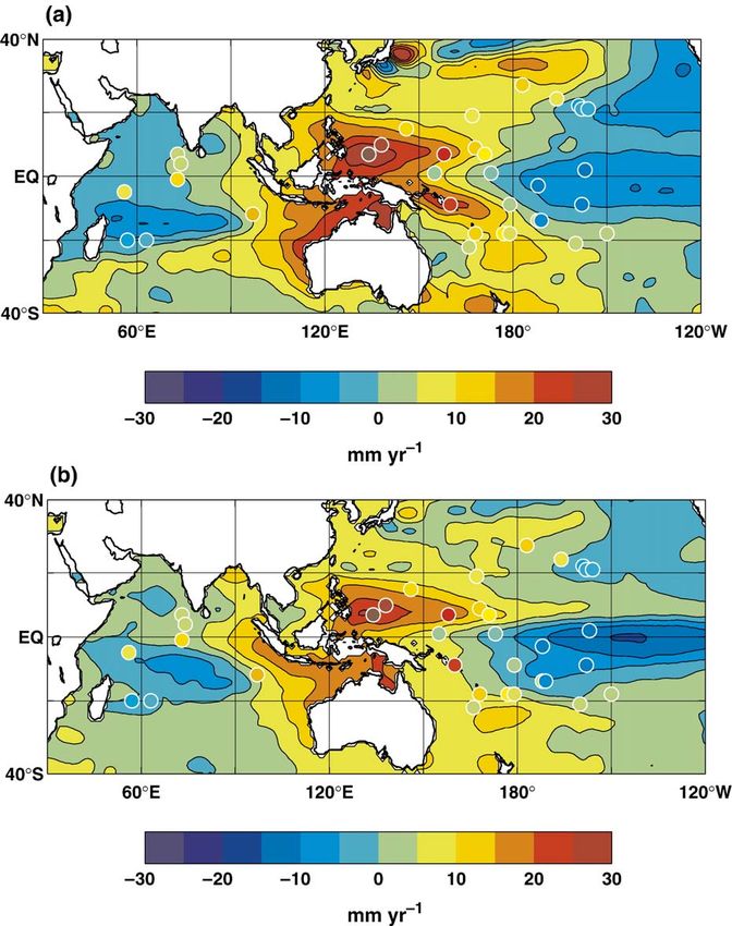
156                              J.A. Church et al. / Global and Planetary Change 53 (2006) 155–168

concerning a sea-level fall at the Maldives have been                movements on either side of the Pacific Ocean are
firmly rebutted by Woodworth (2005), Woodroffe (2005)                attributed to ENSO, rather than being regarded as un-
and Kench et al. (2005). The impacts of sea-level rise on            explained random variations. The technique provides esti-
Tuvalu have also been a subject of considerable con-                 mates of monthly averaged sea level on a near global
troversy (Eschenbach, 2004a,b; Hunter, 2004).                        (65°S–65°N) 1° × 1° ocean grid (essentially the ice free
    The tropical Pacific and Indian Ocean regions have               regions; Chambers et al., 2002; Church et al., 2004;
considerable interannual and decadal sea-level variabil-             Church and White, 2006).
ity associated with the El Niño-Southern Oscillation                     Given the potential vulnerability of the Maldives,
(ENSO), the Asian–Australian monsoon and phenom-                     Tuvalu and other island states in the Pacific and Indian
ena like the North Pacific Decadal Oscillation (Tren-                oceans, we assemble the sea-level data sets described
berth and Hurrell, 1994; Chambers et al., 2002; Han and              above to provide the best possible estimates of sea-level
Webster, 2002; Church et al., 2004). In short tide-gauge             rise for the latter half of the 20th century for these islands.
records, this variability may obscure any longer-term                We also test the veracity of assertions (Mörner, 2004;
sea-level change, or the variability may be misinterpre-             Mörner et al., 2004) that no significant sea-level rise is
ted as a regional change. For example, annual mean sea-              occurring. The data sets and techniques used are described
level at some locations can change by as much as 20–                 briefly in Section 2. The results (Section 3) indicate large
30 cm on interannual time scales.                                    interannual variability of the tropical Pacific and Indian
    The availability of improved data sets over recent               ocean region and clear evidence that global average sea
decades should allow more effective separation of the                level has been rising both over the last decade and the last
short-term variability from the longer-term sea-level rise.          half of the 20th century. We find no evidence for the 30 cm
Of particular importance is the high quality data from the           fall in sea level “in the 1970s to early 1980s” for the
TOPEX/Poseidon and Jason-1 satellite altimeter missions              Maldives as postulated by Mörner et al. (2004).
(January 1993 to present) that allows the basin-wide
scales of sea-level variability to be examined. Also im-             2. The data sets and methods
portant are the sea-level records from high quality tide
gauges at a number of islands in the tropical Pacific                2.1. Preliminaries
Ocean. Many of these were installed in the 1970s or early
1980s to study the evolution of ENSO events and were                    For many studies, tide-gauge and satellite altimeter data
important elements of the Tropical Ocean Global At-                  are corrected for the “inverse barometer” (IB) response of
mosphere project (World Climate Research Program,                    the ocean to variations in atmospheric pressure as this
1985; McPhaden et al., 1998). With an increasing focus               gives the most useful product for many oceanographic
on sea-level rise in the late 1980s, the quality of individual       studies. However, most of the data presented here do not
gauges, and of the network as a whole, has been improved             include this correction as we are interested in observed or
using modern instrumentation with rigorous datum                     relative sea level — that is, sea level relative to the land at
control (most recently using continuous GPS instruments)             any given site. When we do make the IB correction
and the extension of the network to more locations. For              (Church et al., 2004; Ponte, 2006), we use the atmospheric
many of these sites, there are now more than 20 yrs of               pressure data from the NCEP–NCAR 50 year reanalysis
data. However, there are only a few Pacific island records           (Kistler et al., 2001) and assume that sea level responds
extending over the full 52 yrs examined here.                        isostatically to local changes in atmospheric pressure
    Modern statistical techniques have also been developed           relative to the global over-ocean mean.
to combine the best attributes of the in situ and satellite             Glacial Isostatic Adjustment (GIA, also known as
data sets; i.e. the longer in situ records and the broad             post-glacial rebound (PGR), Mitrovica et al., 2001) com-
(essentially global ocean) coverage from satellites. These           pensates tide-gauge or satellite altimeter data for the
techniques, modeled on approaches used to estimate                   changes of ocean basin shape and gravity caused by
global surface temperatures over the last century (e.g.              changes in surface loading with the melting of large ice
Kaplan et al., 1998, 2000; Rayner et al., 2003), use tide-           sheets from the most recent glaciations. Most of the data
gauge data to estimate the amplitude of empirical ortho-             presented here do not include this correction as we are
gonal functions (EOFs) whose spatial structure has been              most interested in relative sea level. We have performed
estimated from the satellite altimeter data. Importantly, this       the reconstruction with the GIA included to get the best
technique takes account of the spatial patterns of sea-level         estimate of the global fields, then removed this correction
variability, rather than regarding variations from the global        to give the best data set for comparisons with tide-gauge
mean as “noise”. For example, the anti-phase sea-level               data and to focus on relative sea-level change.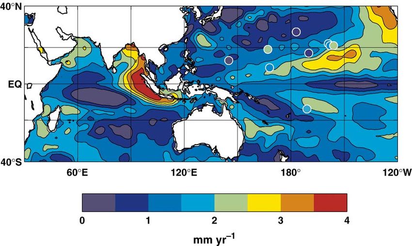
J.A. Church et al. / Global and Planetary Change 53 (2006) 155–168                                      157

    Some tide-gauges records are contaminated by ver-                      analysis is generally not recommended. Where such
tical land movement due to processes at a range of                         datum shifts have occurred, we have treated the sections
spatial scales, from large-scale geological processes (in                  before and after the shift separately, as in Church et al.
addition to GIA) to local harbour effects as a result of,                  (2004). All records are carefully screened for datum shifts
for example, land reclamation and groundwater pump-                        (both jumps and gradual changes). Differences between
ing. No correction for these effects is possible in general.               reconstructed trends (on the 1° × 1° grid) produced with
    All data presented here have had a seasonal (annual                    and without the Metric data are less than 0.1 mm yr− 1 for
plus semi-annual) signal removed. Tide-gauge data have                     both the area-weighted mean and standard deviation. Fig.
also been smoothed over ± 2 months. As we are only                         1 shows the locations referred to in this paper, but the sea-
interested in changes in sea-level at each location, we                    level reconstruction uses data from a global set of island
have matched the means of the data sets over their                         and coastal tide gauges as in Church et al. (2004).
common periods for display purposes.
                                                                           2.3. The TOPEX/Poseidon satellite altimeter data set
2.2. The tide-gauge data set
                                                                              To estimate global sea-level rise from 1993 to 2001
   Most of the tide-gauge data used here (apart from the                   and to estimate the global covariance structure of sea-
data for Funafuti, Section 3.3) are monthly mean sea-                      level variability, we use the TOPEX/Poseidon along-
levels from the data archive of the Permanent Service for                  track data from the Merged Geophysical Data (MGDR-
Mean Sea-Level (PSMSL; Woodworth and Player,                               B) records for January 1993 through December 2001
2003) for January 1950 through December 2001, a                            (cycles 11 to 342, 108 months). All standard corrections
one year extension of the data set used by Church et al.                   recommended by Benada (1997), except the inverse
(2004). We do not consider tide-gauge data after 2001                      barometer correction, were applied. In addition, we
because of delays in submission of data sets to the                        applied a correction for a long-term, spatially uniform
PSMSL. We use primarily RLR (Revised Local                                 drift (∼ 5 mm over the first 5 yrs of the mission, then
Reference) data, but also some Metric data, downloaded                     fixed at 5 mm) in the TOPEX/Poseidon TMR (radiom-
from the PSMSL WWW site (http://www.pol.ac.uk/                             eter)-based water vapour path delay correction (Keihm
psmsl/) in February 2003. The RLR data files are                           et al., 2000) and the estimated altimeter drift (by com-
supported by documentation relating measured sea level                     parison of the altimeter surface heights with tide-gauge
at each site to a constant local datum over the complete                   data; Mitchum, 1998, 2000). The main consequence of
record. The Metric records can have substantial and                        the latter correction is that it compensates for the ∼
unknown datum shifts and their use in time series                          10 mm jump in measured sea-level when the TOPEX

Fig. 1. Location map. A number of sites (Saipan, Kapingamarangi, Port Vila, Lautoka, Apia, Rarotonga and Penrhyn) are not mentioned in the text,
but are shown here as data from their short records are shown on Fig. 2a and b. The RMS variability from smoothed, monthly TOPEX/Poseidon data
from January 1993 to December 2001 is indicated by the shading.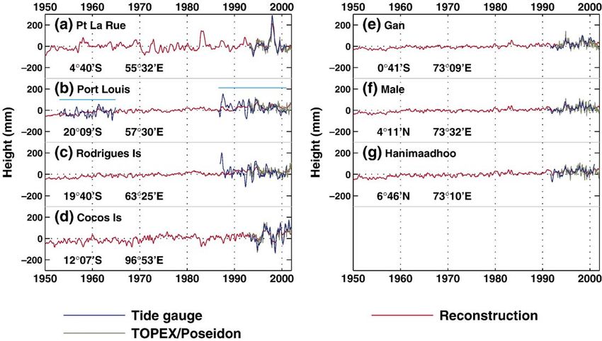
158                             J.A. Church et al. / Global and Planetary Change 53 (2006) 155–168

“side B” altimeter replaced the “side A” altimeter be-              2.5. Uncertainties
cause of age-related problems. The GMSL trend (1993–
2001) is 2.7 mm yr− 1 (with no IB or GIA included in this               The true uncertainty of sea-level trends will be un-
figure).                                                            derestimated if the serial correlation of the time series is
    As we are interested in large space- and time-scale             ignored. In the Indo-Pacific region, the problem is often
phenomena, monthly estimates of sea-level on a 1° × 1°              compounded by substantial interannual excursions in sea
grid were obtained by applying a Gaussian filter, with an           level related to ENSO events. We have derived uncer-
e-folding scale of 300 km applied over a square with                tainty estimates in two ways, both techniques yielding
sides of 800 km, to the along-track data. Satellite alti-           similar results. In the first method, the trend was cal-
meters measure sea-level relative to the centre of the              culated using all the data points in a time series and the
Earth, and should also be corrected for GIA (Tamisiea et            resultant uncertainty estimated assuming that the appro-
al., personal communication), but as our TOPEX/                     priate number of degrees of freedom was given by the
Poseidon data set has been calibrated against tide gauges           record length divided by the integral time scale (Emery
(see above), this effect has essentially been addressed to          and Thompson, 1998, p. 261). The integral time scale was
within an error of about 0.1 mm yr− 1, which is negligible          found to be about 3 months. In the second method, the
for our purposes.                                                   time series was initially averaged into adjacent temporal
                                                                    bins that were sufficiently large for the residual (after trend
2.4. The reconstructed global sea-level fields                      removal) to be statistically uncorrelated. The uncertainty
                                                                    was then calculated by basing the number of degrees of
    We use monthly sea-level values from a global recon-            freedom on the number of bins. The test for correlation
struction as described in Church et al. (2004), extended by         was based on the Durbin–Watson statistic (Von Storch
1 yr to December 2001. Briefly, this sea-level reconstruc-          and Zwiers, 1999, p. 157) or simply on an upper bound (in
tion (from January 1950 to December 2001 and on the                 our case, 0.2) for the value of the lag-1 correlation
same 1° × 1° grid as the TOPEX/Poseidon data) was                   (Ostrom, 1990, p. 29). Both tests yielded similar results.
generated using tide-gauge data (Woodworth and Player,              All uncertainty estimates are expressed as ±1 standard
2003) to estimate the amplitudes of empirical orthogonal            deviation.
functions (EOFs) determined from the 9 year TOPEX/                      All area-averaged trends are either for the whole
Poseidon data set (Chambers et al., 2002; Church et al.,            region covered by the TOPEX/Poseidon data (65°S–
2004). The first 20 EOFs are used in addition to a spatially        65°N, all longitudes) or for the region 40°S–40°N,
constant field (dependent on time but independent of                30°E–120°W (Fig. 1). All such averages are area-
location) which represents the global mean sea-level. This          weighted means.
latter field (referred to as “mode 0” in Church et al., 2004)
is needed as the EOFs reflect the temporal/spatial var-             3. Results
iability of sea-level but cannot adequately represent sig-
nificant changes in global mean sea level. Using EOFs                   The root-mean-square (rms) variability in sea level
from a restricted period to estimate sea level over a longer        for the 9 yrs of satellite data (January 2003 to
period assumes that the large-scale variability can be              December 2001, Fig. 1) reaches a maximum of around
estimated adequately using these EOFs. This is discussed            100 mm along the equator in the eastern Pacific Ocean
in Church et al. (2004), Church and White (2006) and                (the region of the equatorial cold tongue) and at low
Chambers et al. (2002).                                             latitudes north and south of the equator in the western
    The trend in global-mean sea level estimated from this          Pacific. In the Indian Ocean, the variability is a
reconstruction is consistent with estimates from tide-              maximum along a band centred at about 10°S
gauge data (Douglas, 1991, 1997; Holgate and Wood-                  (maximum of about 80 mm) and along the eastern
worth, 2004). Reconstructed sea-level time series at tide-          Indian Ocean boundary. This variability (see Church et
gauge sites also agree well with the original tide-gauge            al., 2004) reflects that the Pacific Ocean region is the
data, even when the tide-gauge data at a location are               centre of the strongest interannual variability of the
withheld from the reconstruction (Church et al., 2004).             climate system, the coupled atmosphere-ocean ENSO
The main advantage of this data set is that it provides             phenomenon, and the largest sea-level variations in the
estimates of the regional and global variations of sea-             world on time scales of months to years and space
level and time series of estimated sea-level at individual          scales of several hundred kilometers and longer. During
locations over a longer period than is often available              El Niños, sea level is anomalously high (by tens of
from individual tide-gauge records alone.                           centimeters) in the eastern tropical Pacific and low in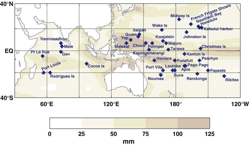
J.A. Church et al. / Global and Planetary Change 53 (2006) 155–168                                       159

the western tropical Pacific. This large interannual                        reflect the (weak) El Niño like conditions in the early
variability highlights the difficulty in accurately                         years of the TOPEX/Poseidon mission and the more La
determining long-term sea-level trends and the need                         Nina like conditions in 2001. The trends over the same
for long, high-quality records, a point that will be                        period from the reconstruction (Fig. 2b) are similar to
evident when we examine the individual tide-gauge                           those from TOPEX/Poseidon (correlation of 0.87),
records.                                                                    demonstrating the ability of the reconstruction technique
   The sea-level trends in the Pacific and Indian Ocean                     to reproduce the large-scale interannual variability,
over the first 9 yrs of the TOPEX/Poseidon mission                          particularly in the tropical Pacific and Indian Oceans.
(Fig. 2a) demonstrate the impact of this interannual                        While there is large-scale spatial structure in the pattern of
variability. The large rates of sea-level rise over the                     sea-level rise over the TOPEX/Poseidon period (1993 to
western Pacific and eastern Indian Ocean (approaching                       2001), a series of studies (see, for example, Leuliette et al.,
30 mm yr− 1) and sea-level falls in the eastern Pacific and                 2004; Church et al., 2004) have clearly demonstrated a
western Indian Ocean (rates approaching −10 mm yr− 1)                       global average sea-level rise over this period of about

Fig. 2. Map of sea-level trends for (a) TOPEX/Poseidon data and (b) the reconstruction for 1993 to 2001. Tide-gauge trends for the same period are
shown where available by the coloured dots.
160 J.A. Church et al. / Global and Planetary Change 53 (2006) 155–168
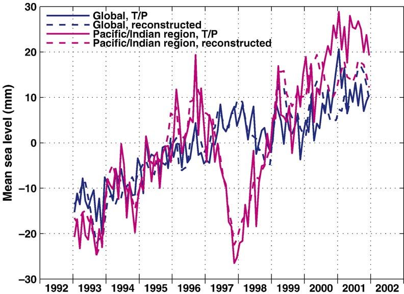
Fig. 3. Global averaged and Pacific/Indian Ocean averaged sea levels over the period 1993 to 2001. The Pacific/Indian Ocean average is for the region
shown in Figs. 1, 2 and 6.
3 mm yr− 1 (Fig. 3). For the region shown in Fig. 1 the relative sea-level rise (Table 1, column 5) have large
trends from both the TOPEX/Poseidon data and from the uncertainties. Even for the longest records considered here
reconstruction are larger (Fig. 3), about 4 mm yr− 1 (52 yrs), the uncertainties are 0.3 mm yr− 1 or greater. As
(4.3 mm yr− 1 for TOPEX/Poseidon and 3.6 mm yr− 1 for the record length gets shorter these uncertainties increase
the reconstruction). significantly and are several mm yr− 1 for a number of the
Tide-gauge trends give the same overall pattern of sea- shorter records (less than 24 yrs, not included in Table 1).
level change as the TOPEX/Poseidon and reconstructed The few tide-gauge records that commence in the
sea-levels, but it is clear that the small number of tide- 1950s or earlier (Guam, Chuuk, Kwajalein, Kanton Island
gauge records alone can not give a clear impression of the and Christmas Island) indicate that interannual variability
overall pattern, and the mean trend over the tide gauges in sea level prior to 1970 is smaller (e.g. less than 50% at
would not necessarily give an accurate representation of Guam, Kanton Island and Pago Pago) than that of the post
the trend over the whole region. For example, for the South 1970 data. This difference in variability is similar to that
Pacific Sea Level and Climate Monitoring Project, the displayed by the SOI index (Torrence and Webster, 1999).
average for the 11 longest records (averaging just under For those locations strongly affected by ENSO events, the
11 yrs in 2004) is 6.0 mm yr− 1 (see page 2 of Mitchell, reconstructions reproduce much of the observed variabil-
2004), substantially larger than the global average value of ity. The average correlation between the reconstructed and
about 3 mm yr− 1and the regional average of about 4 mm observed sea levels is 0.88 and the residual variance is
yr− 1 from both the satellite data and the reconstruction. 23.4% of the observed variance.
For the higher latitude gauges (Wake Island, Noumea,
3.1. Pacific Ocean Suva, Midway Island, Johnston Island, French Frigate
Shoals, Nawiliwili Bay, Honolulu, Kahului Harbour,
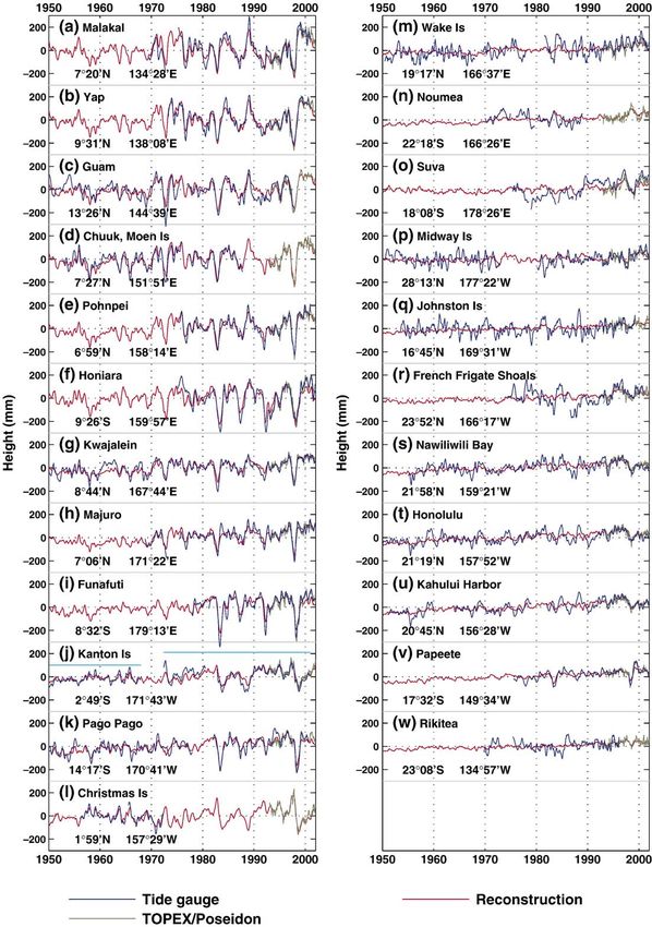
We now consider the tide-gauge data (for continuous, Papeete and Rikitea; Fig. 4, right-hand side), the
or near continuous, records longer than 24 yrs) along with variability is of reduced amplitude but higher frequency,
the reconstructed sea levels and the corresponding compared with stations nearer the equator. At least part
TOPEX/Poseidon data (Fig. 4). For those locations of this variability is thought to be a result of westward
located within about 15° of the equator (Guam, Chuuk, propagating Rossby waves (Fu and Chelton, 2001).
Yap, Pohnpei, Malakal, Kwajalein, Majuro, Funafuti, Firing et al. (2004) have also discussed the role of large-
Honiara, Pago Pago, Kanton Island and Christmas Island), scale wind variability in forcing sea-level perturbations
sea level has large interannual variability (peak-to-peak at Honolulu. These Rossby waves will be largely
amplitudes as large as 45 cm) associated with ENSO eliminated from the satellite altimeter data used here by
events (Fig. 4, left-hand side). As a result, estimates of the spatial filtering and will not be well represented in theJ.A. Church et al. / Global and Planetary Change 53 (2006) 155–168 161 Fig. 4. Time series of tide-gauge (blue), TOPEX/Poseidon (green) and reconstructed sea level (red) for Pacific Ocean sites with more than 24 yrs of tide-gauge data. The light blue lines on panel (j) show the time spans of the two separate records for this site.
162                                  J.A. Church et al. / Global and Planetary Change 53 (2006) 155–168

Table 1
Locations, time spans and sea-level trends for Pacific Ocean locations with more than 24 yrs of data
Location                Position            Time span            Years Tide-gauge Relative recons trend Tide-gauge trend Relative recons
                                                                       trend      (tide-gauge time span) with GIA and IB trend (52 yrs)
Malakal                 134°28′E 7°20′N     06/1969 – 12/2000    32       1.0 ± 1.2   − 0.3                1.5             0.5
Yap                     138°08′E 9°31′N     04/1973 – 12/2000    28      −0.4 ± 1.3   − 0.8                0.1             0.8
Guam                    144°39′E 13°26′N    01/1950 – 11/1997    48      −0.6 ± 0.5     0.5               −0.3             1.1
Chuuk Moen Is           151°51′E 7°27′N     11/1952 – 10/1987    35       0.9 ± 0.7     2.1                1.4             1.7
Pohnpei                 158°14′E 6°59′N     04/1975 – 12/2000    26       1.8 ± 1.3     1.2                2.4             1.8
Honiara                 159°57′E 9°26′S     12/1974 – 12/2001    27      −0.1 ± 1.6     0.2                0.3             0.6
Kwajalein               167°44′E 8°44′N     01/1950 – 12/2001    52       1.3 ± 0.3     1.9                1.9             1.9
Majuro                  171°22′E 7°06′N     10/1968 – 12/2001    33       2.8 ± 0.6     2.3                3.3             2.1
Funafuti                179°13′E 8°32′S     11/1977 – 12/2001    24       2.3 ± 1.5     1.0                2.8             1.6
Kanton Is               171°43′W 2°48′S     01/1950 – 12/1967    18       2.3 ± 0.8     0.7                3.0             1.4
Kanton Is               171°43′W 2°49′S     05/1972 – 12/2000    29      −0.4 ± 0.8     2.0                0.1             1.4
Pago Pago               170°41′W 14°17′S    01/1950 – 08/2000    51       1.6 ± 0.3     1.8                2.1             1.8
Christmas Is            157°29′W 1°59′N     02/1974 – 12/2000    27      −0.1 ± 1.3     1.5                0.6             0.9
Wake Is                 166°37′E 19°17′N    06/1950 – 12/2001    52       2.0 ± 0.3     1.2                2.5             1.2
Noumea                  166°26′E 22°18′S    03/1967 – 12/2000    34       0.2 ± 0.4     1.8                0.9             1.7
Suva                    178°26′E 18°08′S    05/1975 – 12/2001    27       6.7 ± 0.8     1.4                7.3             0.8
Midway Is               177°22′W 28°13′N    01/1950 – 12/2001    52       0.3 ± 0.3     0.8                0.9             0.7
Johnston Is             169°31′W 16°45′N    06/1953 – 04/1999    46       0.4 ± 0.3     1.3                0.9             1.4
French Frigate Shoals   166°17′W 23°52′N    07/1974 – 12/2000    27       1.0 ± 1.0     1.9                1.5             1.5
Nawiliwili Bay          159°21′W 21°58′N    01/1955 – 12/2001    47       1.3 ± 0.3     1.7                1.8             1.7
Honolulu                157°52′W 21°19′N    01/1950 – 12/2001    52       1.3 ± 0.2     1.9                1.8             1.9
Kahului Harbor          156°28′W 20°45′N    01/1951 – 12/2001    51       2.1 ± 0.2     2.0                2.5             1.9
Papeete                 149°34′W 17°32′S    07/1975 – 12/2001    27       2.9 ± 0.5     2.2                3.4             1.8
Rikitea                 134°57′W 23°08′S    10/1969 – 02/1996    26       1.0 ± 0.6     1.6                1.3             1.3

EOFs used in the reconstruction. As a result, the recon-                    Shoals and Suva, both of which have jumps and trends
structed sea-levels do not reproduce much of this high                      that are anomalous compared with “nearby” locations, see
frequency variability but they do reproduce some of the                     above) and Funafuti (contaminated by vertical land move-
major features and the long-term trends. The records for                    ment, see Section 3.3), and using the longer Kanton Island
Suva and French Frigate Shoals have gaps in the sea-                        record, the average rate of relative sea-level rise for the
level data and the character of the record is somewhat                      remaining 20 locations is 1.0 mm yr− 1 for the tide-gauge
different from nearby locations, calling into question the                  data and 1.3 mm yr− 1 for the reconstructions (for the same
datum stability of these two gauges.                                        period). However, the observations contain a larger range
    The significant interannual variability indicates the                   of rates of relative sea-level change, presumably as a result
need for long records to reliably estimate the rate of sea-                 of poorly quantified vertical movements (see Section 3.3
level rise from individual sites. For example, even for the                 for an example), the large interannual sea-level variability
52 year long record from Kwajalein, the uncertainty in                      and the fact that the reconstruction does not reproduce
the relative sea-level trend is as large as ± 0.3 mm yr− 1.                 some of the smaller-scale variability. After making the
The stated uncertainties (Table 1) are from the variability                 GIA and inverse barometer corrections, the corresponding
in the sea-level records only.                                              rates of (absolute) sea-level rise are 1.5 mm yr− 1 for the
    For the few Pacific Island records greater than 50 years                observations and 1.6 mm yr− 1 for the reconstructions,
length (6 locations in Table 1), the average rate of relative               again consistent with global average rates of sea-level rise.
sea-level rise is 1.4 mm yr− 1. The corresponding average
rate for relative sea-level rise from the reconstructions of                3.2. Indian Ocean
1.6 mm yr− 1 is not significantly different. After GIA and
inverse barometer corrections, the mean (absolute) tide-                        There are far fewer island tide gauges in the Indian
gauge trend is 2.0 mm yr− 1, consistent with the global                     Ocean than the Pacific Ocean (only seven open-ocean
average rate of sea-level rise.                                             island sites north of 40°S; Fig. 5) and the records are
    For the Pacific Ocean, there are 23 locations with 24 or                much shorter. There is significant interannual variability
more years of data (Table 1). Excluding the two locations                   in sea-level in the southern Indian Ocean (the maximum
with apparent problems in the record (French Frigate                        is at about 10° to 20°S) but there is low variability near
J.A. Church et al. / Global and Planetary Change 53 (2006) 155–168 163 Fig. 5. Time series of tide-gauge (blue), TOPEX/Poseidon (green) and reconstructed sea level (red) for Indian Ocean sites. The light blue lines on panel (b) show the time spans of the two separate records for this site. the Maldives. The two longest Indian Ocean records error estimate is likely to be substantially underestimated (starting in 1986) are from Port Louis (20°9′S, 57°30′E; because the record is so short that it is not possible to 1953 to 1964 and a separate record from 1986 to 2000) reliably estimate an integral time scale. The recon- and 600 km to the east at Rodrigues Island (19°40′S, structed sea levels over the longer 1950 to 2001 period 63°25′E; 1986 to 2000). The data from the two sites have give rates of relative sea-level rise of 1.5, 1.3 and 1.5 mm similar variability (correlation 0.72, significant at the yr− 1 (with error estimates of about 0.5 mm yr− 1) at Port 99% level) with Rodrigues Island leading by 2 months, Louis, Rodrigues and Cocos Islands respectively. presumably as a result of westward propagation and/or In the equatorial band, the three locations in the advection of sea-level anomalies. The observed vari- Maldives (Gan, 0°41′S; Male, 4°11′N; Hanimaadhoo, ability from TOPEX/Poseidon and tide-gauge data for 6°46′N) each have short records, only starting in 1992. The both sites is similar, both having greater variance than the variability of these three records (remembering that all reconstructed sea levels. The greater variability of the records have had the seasonal signal removed and have tide-gauge records is likely a result of both mesoscale then been smoothed) is smaller than at Port Louis and the variability and Rossby wave influence and the fact that three records are strongly correlated with each other the reconstruction technique only captures large-scale (correlations of 0.53, 0.73 and 0.67 between the three pairs, signals. Despite these differences, the tide-gauge and all significant at the 99% level) and with the reconstruction reconstructed trends have some similarities over the (correlations of 0.85, 0.64 and 0.82). As found by Singh common periods. Both these records show relative sea- et al. (2001), we find that the rates of sea-level rise are large level falling at rates of about 3 ± 2 mm yr− 1 from 1986 to in these very short records (8.4 mm yr− 1, 3.7 mm yr− 1, and 2000. The satellite altimeter data starting in 1993 also 4.4 mm yr− 1, respectively). (Note however that this result shows sea-level falling in this region. An earlier 12 year is in contrast to Mörner et al. (2004) who state, but do not record for Port Louis (1953 to 1964) indicates a sea-level justify, that the records “reveal a total absence of any rise of about 2 mm yr− 1, and these results together secular trend”.) We do not expect the rates from these short demonstrate again that short decadal changes may not be records to be representative of longer-term trends. Our representative of long-term trends. Similarly the record error estimates of less than 2 mm yr− 1 (Table 2) are likely from Cocos Island (1993 to 2000) is too short to give a to be substantially underestimated because the record is so reliable long-term trend. Here the large variability is well short that it is not possible to reliably estimate an integral reproduced in the reconstruction and the estimated trend time scale. Also, these gauges may be significantly from the observations is large at 12 ± 5 mm yr− 1. Our affected by vertical land motion. The rates over the
164                                  J.A. Church et al. / Global and Planetary Change 53 (2006) 155–168

Table 2
Locations, time spans and sea-level trends for Indian Ocean locations
Location         Position            Time span             Years    Tide-gauge    Relative recons trend    Tide-gauge trend   Relative recons
                                                                    trend         (tide-gauge time span)   with GIA and IB    trend (52 yrs)
Pt La Rue        55°32′E 4°40′S      02/1993 – 12/2000      8         5.6 ± 6.6   − 1.6                      5.2              0.5
Port Louis       57°30′E 20°09′S     01/1953 – 11/1964     12         1.9 ± 1.5     3.7                      2.6              1.5
Port Louis       57°30′E 20°09′S     08/1986 – 12/2000     14       − 3.7 ± 1.5     1.8                    − 3.0              1.5
Rodrigues Is     63°25′E 19°40′S     12/1986 – 12/2000     14       − 3.6 ± 1.9     0.7                    − 2.6              1.3
Cocos Is         96°53′E 12°07′S     01/1993 – 12/2001      9       12.1 ± 4.6      5.1                    10.7               1.5
Gan              73°09′E 0°41′S      08/1991 – 12/2000      9         8.4 ± 1.7     3.5                      7.6              1.0
Male             73°32′E 4°11′N      12/1990 – 12/2000     10         3.7 ± 1.4     2.0                      3.1              1.0
Hanimaadhoo      73°10′E 6°46′N      08/1991 – 12/2000      9         4.4 ± 1.9     1.3                      3.3              1.2

52 year period from the reconstruction are 1.0, 1.0 and                     adjacent to the UHSLC gauge is sinking relative to the
1.2 mm yr− 1 at the three sites.                                            land adjacent to the NTC tide-gauge benchmark (about
    Woodroffe (2005) uses geological evidence to infer                      2.5 km away) by 0.6 mm yr− 1. This tilting may be caused
rates of sea-level rise over recent decades. He gives                       by tectonic movement or (most probably) local subsi-
geological evidence of a net increase of 6 mm or less in                    dence (for example, due to groundwater withdrawal) and
sea-level over the 20–30 year period up to 1989 at                          demonstrates that even on a single island, the relative sea-
Veymandoo, Kolamadulu Atoll in the Maldives. This is                        level trend may differ by as much as 0.6 mm yr− 1. In
consistent with our reconstructed time series for the                       addition, the UHSLC gauge is sinking on its foundations
Maldives where our reconstructed time series at Male                        by an additional 0.6 mm yr− 1, giving a total sinking rate
(our closest site) gives a rate of 0.4 mm yr− 1 over 1960–                  for the UHSLC gauge of 1.2 mm yr− 1.
1989 — consistent with the mean rate of 0.2 to 0.3 mm                           Detailed analysis of the Funafuti data from 1978 to
yr− 1 implied by the (maximum) 6 mm rise over 20–                           2001 inclusive (Hunter, 2004; the original 2002 report
30 yrs from the geological data.                                            available at http://staff.acecrc.org.au/~johunter/tuvalu.
    Further west at Port La Rue (4°40′S), the variability                   pdf) indicates a sea-level rise relative to the NTC tide-
is again high in the short (less than 10 yrs) record but the                gauge benchmark (which is believed to be on stable
variability is well represented in the reconstruction. The                  foundations) of 0.8 ± 1.9 mm yr− 1. If the data from the
52 year relative trend at this site is 0.5 mm yr− 1.                        UHSLC gauge are used directly with no allowance for
                                                                            the apparent sinking of the tide gauge, the calculated
3.3. Sea level at Funafuti, Tuvalu                                          trend is substantially larger. The rate of relative sea-level
                                                                            rise (over the time span of the record) from the recon-
    Sea-level change at Funafuti, Tuvalu has been the                       structed sea-level at Funafuti is 1.0 mm yr− 1, in much
subject of intense interest as a result of Tuvalu's low-lying               better agreement with the Hunter estimate and appar-
nature and reports that flooding is becoming increasingly                   ently not contaminated by the subsidence of the older
common. There are two records available at Funafuti: the                    tide-gauge. Over 1950 to 2001, the relative rate of sea-
first record (from a gauge operated by the University of                    level rise at Funafuti estimated from the reconstruction
Hawaii Sea Level Centre (UHSLC)) commences in 1977                          is 1.6 ± 0.5 mm yr− 1.
and the second (from a gauge operated by the Australian                         A more recent analysis using tide-gauge data from
National Tidal Centre (NTC)) in 1993. Eschenbach                            1978 to 2004 inclusive indicates a sea-level rise of 2.3 ±
(2004a,b) quotes (but does not substantiate) a “best es-                    1.6 mm yr− 1 relative to the NTC tide-gauge benchmark.
timate” of the rate of rise of 0.07 mm yr− 1, apparently                    This is higher than, but statistically consistent with, the
based on an analysis of Mitchell et al. (2001) for the period               earlier estimate of 0.8 ± 1.9 mm yr− 1. Taken together, we
1977–1998, with the “likely” (but, again, unsubstantiated)                  conclude that a best estimate of the rate of relative sea-
range of −1 to 0.5 mm yr− 1 based on surrounding gauges                     level rise at Funafuti is 2 ± 1 mm yr− 1.
and an estimate of ocean thermal expansion. Note that the
period 1977–1998 ends at the peak of the 1997/98 ENSO                       3.4. Pattern of sea-level rise for 1950 to 2001
event and thus the estimate of 0.07 mm yr− 1 is biased low
relative to the long-term trend.                                               Since the altimeter record is short, we use the recon-
    A thorough analysis of survey data at Funafuti (Ki-                     structed sea levels to estimate the pattern of relative sea-
lonsky, personal communication) shows that the land                         level rise over the period from January 1950 to December
J.A. Church et al. / Global and Planetary Change 53 (2006) 155–168 165 Fig. 6. Map of sea-level trends from the reconstruction over the 52 year period. Trends from the longer tide-gauge records are also shown by the coloured dots. 2001 (Fig. 6). It should be noted that the scale used in Fig. of high sea-level rise in the north east Pacific, a minimum 6 (for the 52-year reconstruction) is about an order of in rise in the western equatorial Pacific and in a band magnitude smaller than the scale used in Fig. 2 and that across the South Indian Ocean, consistent with the the rates of sea-level change are more spatially uniform. reconstructed patterns and the low rates of rise from the This smooth pattern is the result of averaging over a geological data (Woodroffe, 2005). However, there are also number of ENSO events and as a result the rate of change significant differences between the estimates and in not being overwhelmingly influenced by a single event. particular the maximum south-west of Sumatra is not as The average rate of sea-level rise over this region is strong in these steric height estimates as in the reconstruction. 1.45 mm yr− 1, which, after the subtraction of ∼−0.3 mm yr− 1 for GIA (giving about 1.75 mm yr− 1), is close to the 4. Conclusions global average rate estimated by Church et al. (2004). The maximum rate is just over 4 mm yr− 1 southwest of For 1993 to 2001, the altimeter data and the recon- Sumatra in the eastern equatorial Indian Ocean and the structed sea levels show the average sea level in the region minimum is close to 0 mm yr− 1 just south of the equator covered by Fig. 1 rising at about 4.3 mm yr− 1, similar to in the central Indian Ocean. In the Pacific, the major but slightly larger than the regional TOPEX/Poseidon large-scale features are a maximum in the rate of sea-level trend of about 3.6 mm yr− 1. A number of recent studies rise in a tongue-like feature in the north-eastern Pacific and (Leuliette et al., 2004; Church et al., 2004; Holgate and a minimum along the Equator and in the western equatorial Woodworth, 2004; Cazenave and Nerem, 2004) also Pacific Ocean (particularly east of Papua New Guinea). confirm the global average sea-level rise from altimeter Also shown on Fig. 6 are the trends from the 9 longest studies, with estimates varying over a small range de- island tide-gauge records over the period 1950 to 2001. pending on the details of the calculation. In direct contrast, These gauges are in general agreement with the recon- Mörner (2004) shows a plot (his Fig. 2) of sea-level struction but stronger confirmation of the patterns is not variations from October 1992 to April 2000, based on possible with the available in situ data. The gradient in sea- TOPEX/Poseidon data, ostensibly showing that there is level rise (low in the north-west and high in the south-east) no rise in GMSL. This is described as being “raw data”, along the Hawaiian island chain (21°N, 157°W) is confirmed and appears to be cycle-by-cycle (10 day) averages of from the estimates of ocean steric sea-level trends and tide- global mean sea-level. Unfortunately, there is neither a gauge records corrected for gross vertical motion due to description of the data that were used to produce this volcanism estimated using GPS data (Caccamise et al., figure, nor a reference to its source. In order to be a 2005). Lombard et al. (2005) show two estimates of ocean meaningful estimate of global mean sea-level, a number steric height trends. Both of these estimates have a tongue of corrections would have been necessary, including wet
166                              J.A. Church et al. / Global and Planetary Change 53 (2006) 155–168

tropospheric path delay, dry tropospheric path delay, ion-               For the six complete records from the Pacific Ocean,
ospheric path delay, sea-state bias and tides, but it is             there is an increase in variance of the monthly sea-level
unclear which, if any, of these well-known and under-                data after 1970, particularly for the stations within 15° of
stood corrections have been applied.                                 the equator, for which the variance after 1970 is more than
    The altimeter data and the reconstructions reveal a              double the pre-1970 variance (commensurate with changes
large-scale pattern of sea-level change over this period —           in the variability of the SOI index; Torrence and Webster,
sea-level falling in the eastern Pacific and the western             1999). This increase in variance (if maintained at the new
Indian Ocean and rising in the western Pacific and eastern           level into the future) together with a rise in the mean sea-
Indian Ocean. The rates of change are large and are                  level will result in an increase in the frequency of extreme
characteristic of interannual climate variability. There is in       events of a given magnitude and has important implica-
general a good agreement between the tide-gauge data,                tions for the local impacts of sea-level rise.
the altimeter data and the reconstructions for the period of             The pattern of sea-level rise from the reconstructions
overlap. In the Indian Ocean, the tide-gauge records at the          (Fig. 6) is consistent with the trend to more frequent,
Maldives indicate large rates of relative sea-level rise in          persistent and intense ENSO events in the past 2 decades
agreement with Singh et al. (2001) and Woodworth                     (Folland et al., 2001). The lowest estimated rates of sea-
(2005), and in disagreement with Mörner et al. (2004).               level rise over this 52 year period are close to zero south-
    For the 1950 to 2001 period, there is a good agreement           west of the Maldives, consistent with geological data of low
between the observed and the reconstructed sea-level                 rates of sea-level rise in this region (Woodroffe, 2005). For
variability in the equatorial region. However, there are             the Maldives themselves, the estimated rate of sea-level rise
only six complete island tide-gauge records, all in the              over the 52 year period is close to 1 mm yr− 1 and, in
Pacific Ocean. The average trend for these records gives a           contrast to Mörner et al. (2004), we find that there is no
relative sea-level rise of 1.4 mm yr− 1 (1.6 mm yr− 1 from           indication of a fall in sea-level of 20 to 30 cm at any time in
the reconstructed sea-level at these locations). Corrected           the last 30 yrs (which would imply a rate of fall of between
for GIA and changes in atmospheric pressure, the average             7 and 10 mm yr− 1 over 30 yrs, and double that over the
tide-gauge trend is 2.0 mm yr− 1. Even for the longest               “1970s to early 1980s” specified by Mörner et al. (2004)).
records, particularly those within 15° of the equator in the         This drop in sea-level has also been shown to be incon-
Pacific Ocean, the large ENSO related interannual                    sistent with geological data (Woodroffe, 2005; Kench et al.,
variability means that there is considerable uncertainty             2005). Our best estimate of the rate of relative sea-level rise
in the trends from individual gauges.                                at Funafuti is 2 ± 1 mm yr− 1. Clearly sea level in this region
    For the gauges with records longer than 24 years (but            is rising, and we expect the direct and indirect (e.g. in-
significantly shorter than 52 years), there are larger dif-          creased frequency of extreme events) effects of this rise and
ferences between the trends from individual tide gauges              the observed increase in the rate of rise (Church and White,
and the reconstructed trends. These differences are at least         2006) will cause serious problems for the inhabitants of
partly the result of poorly known vertical land motions              some of these islands during the 21st century.
and the large interannual variability. One notable issue
was at Funafuti where the reconstruction gave a lower rate           Acknowledgements
of sea-level rise than the tide-gauge record if no allowance
is made for sinkage of the UHSLC tide gauge. When the                   This paper is a contribution to the CSIRO Climate
trends from locations with greater than 24 yrs of data are           Change Research Program and was supported by the
averaged, the estimated rate of relative sea-level rise is           Australian Government's Cooperative Research Centres
1.0 mm yr− 1 from the tide-gauge data, slightly less than            Programme through the Antarctic Climate and Ecosys-
the 1.3 mm yr− 1 from the reconstructions. After making              tems Cooperative Research Centre (ACE CRC). TOPEX/
the GIA and inverse barometer corrections, the cor-                  Poseidon data were obtained from the NASA Physical
responding rates of sea-level rise are 1.5 mm yr− 1 for the          Oceanography Distributed Active Archive Centre at the
observations and 1.6 mm yr− 1 for the reconstructions,               Jet Propulsion Laboratory/California Institute of Tech-
consistent with global average rates of sea-level rise.              nology. The University of Hawaii Sea-Level Centre
Unfortunately, there are no long records from island tide            (UHSLC) provided the data for Honiara. The National
gauges in the Indian Ocean and it is necessary to rely on            Tidal Centre, Bureau of Meteorology, Australia provided
the reconstructions for information of sea-level change              the data for Funafuti, Tuvalu, which was collected as part
over the 1950 to 2001 period. Some support for the pattern           of the South Pacific Sea Level and Climate Monitoring
of rise comes from thermal expansion data (Lombard                   Project, which was funded by the Australian Agency for
et al., 2005) and geological data (Woodroffe, 2005).                 International Development (AusAID). NCEP Reanalysis
J.A. Church et al. / Global and Planetary Change 53 (2006) 155–168 167
data, provided by the NOAA-CIRES Climate Diagnostics Kaplan, A., Cane, M.A., Kushnir, Y., Clement, A.C., Blumenthal, M.B.,
Center, Boulder, Colorado, USA, is acquired from their Rajagopalan, B., 1998. Analyses of global sea surface temperature
1856–1991. Journal of Geophysical Research 103, 18567–18589.
Web site at http://www.cdc.noaa.gov/. Kaplan, A., Kushir, Y., Cane, M.A., 2000. Reduced space optimal inter-
polation of historical marine sea level pressure. Journal of Climate 13,
2987–3002.
References Keihm, S., Zlotnicki, V., Ruf, C., 2000. TOPEX microwave radiometer
performance evaluation. IEEE Transactions on Geoscience and
Benada, J.R., 1997. PO.DAAC Merged GDR (TOPEX/POSEIDON) Gen- Remote Sensing 38, 1379–1386.
eration B User's Handbook, Version 2.0. JPL PO.DAAC D-11007. Jet Kench, P.S., Nichol, S.L., McLean, R.F., 2005. Comment on “New
Propulsion Laboratory, California Institute of Technology, Pasadena. perspectives for the future of the Maldives” by Morner, N.A., et al.
Caccamise, Dana J., Merrifield, Mark A., Bevis, Michael, Foster, [Global Planet. Change 40 (2004), 177–182]. Global and Planetary
James, Firing, Yvonne L., Schenewerk, Mark S., Taylor, Frederick Change 47, 67–69.
W., Thomas, Donald A., 2005. Sea level rise at Honolulu and Hilo, Kilonsky, B., University of Hawaii Sea Level Centre, personal
Hawaii: GPS estimates of differential land motion. Geophysical communication.
Research Letters 32, L03607. doi:10.1029/2004GL021380. Kistler, R., et al., 2001. The NCEP-NCAR 50-year reanalysis: monthly
Cazenave, A., Nerem, R.S., 2004. Present-day sea level change: ob- means CD-ROM and documentation. Bulletin of the American
servations and causes. Review of Geophysics 42, RG3001. Meteorological Society 82, 247–267.
doi:10.1029/2003RG000139. Leuliette, E.W., Nerem, R.S., Mitchum, G.T., 2004. Calibration of
Chambers, D.P., Melhaff, C.A., Urban, T.J., Fuji, D., Nerem, R.S., 2002. TOPEX/Poseidon and Jason Altimeter Data to construct a continuous
Low-frequency variations in global mean sea level: 1950–2000. record of mean sea level change. Marine Geodesy 27, 79–94.
Journal of Geophysical Research 107, 3026. doi:10.1029/ Lombard, Alix, Cazenave, Anny, Le Traon, Pierre-Yves, Ishii,
2001JC001089. Masayoshi, 2005. Contribution of thermal expansion to present-
Church, J.A., White, N.J., 2006. A 20th century acceleration in global sea- day sea-level change revisited. Global and Planetary Change 48,
level rise. Geophysical Research Letters 33, L01602. doi:10.1029/ 303–312.
2005GL024826. McPhaden, M.J., Busalacchi, A.J., Cheney, R., Donguy, J.R., Gage, K.S.,
Church, J.A., White, N.J., Coleman, R., Lambeck, K., Mitrovica, J.X., Halpern, D., Ji, M., Julian, P., Meyers, G., Mitchum, G.T., Niiler, P.P.,
2004. Estimates of the regional distribution of sea-level rise over Picaut, J., Reynolds, R.W., Smith, N., Takeuchi, K., 1998. The
the 1950 to 2000 period. Journal of Climate 17, 2609–2625. Tropical Ocean Global Atmosphere (TOGA) observing system: a
Douglas, B.C., 1991. Global sea level rise. Journal of Geophysical decade of progress. Journal of Geophysical Research 103,
Research 96, 6981–6992. 14,169–14,240.
Douglas, B.C., 1997. Global sea rise: a redetermination. Surveys in Mitchell, W., 2004. Monthly data report no 144 (December 2004), the
Geophysics 18, 279–292. South Pacific sea level and climate monitoring project. Bureau of
Emery, W.J., Thompson, R.E., 1998. Data analysis methods in physical Meteorology. Available from http://www.bom.gov.au/oceanogra-
oceanography. Pergamon. 634 pp. phy/projects/spslcmp/reports.shtml.
Eschenbach, Willis, 2004a. Tuvalu not experiencing increased sea Mitchell, W., Chittleborough, J., Ronai, B., Lennon, G.W., 2001. Sea
level rise. Energy and Environment 15, 527–543. Level Rise in Australia and the Pacific. Proceedings of the Pacific
Eschenbach, Willis, 2004b. Response to John Hunter's review. Energy Islands Conference on Climate Change, Climate Variability and
and Environment 15, 931–935. Sea Level Rise published by National Tidal Facility Australia.
Firing, Y.I., Merrifield, M.A., Schroeder, T.A., Qiu, B., 2004. Interdecadal Flinders Press. ISBN: 0-9579264-0-5, pp. 47–57.
sea level fluctuations at Hawaii. Journal of Physical Oceanography 34, Mitchum, G.T., 1998. Monitoring the stability of satellite altimeters
2514–2524. with tide gauges. Journal of Atmospheric and Oceanic Technology
Folland, C.K., Karl, T.R., Christy, J.R., Clarke, R.A., Gruza, G.V., 15, 721–730.
Jouzel, J., Mann, M.E., Oerlemans, J., Salinger, M.J., Wang, S.-W., Mitchum, G.T., 2000. An improved calibration of satellite altimetric
2001. Observed climate variability and change. In: Houghton, J.T., height using tide gauge sea levels with adjustment for land motion.
Ding, Y., Griggs, D.J., Noguer, M., van der Linden, P., Dai, X., Marine Geodesy 23, 145–166.
Maskell and, K., Johnson, C.I. (Eds.), Climate Change 2001: The Mitrovica, J.X., Milne, G.A., Davis, J.L., 2001. Glacial isostatic ad-
Scientific Basis. Contribution of Working Group 1 to the Third justment on a rotating earth. Geophysical Journal International
Assessment Report of the Intergovernmental Panel on Climate 147, 562–578.
Change. Cambridge University Press, pp. 99–181. Mörner, N.-A., 2004. Estimating future sea level changes from past
Fu, L.-L., Chelton, D.B., 2001. Large-scale ocean circulation. In: Fu, L.-L., records. Global and Planetary Change 40, 49–54.
Cazenave, A. (Eds.), Satellite Altimetry and Earth Sciences: A Hand- Mörner, N.-A., Tooley, M., Possnert, G., 2004. New perspectives for the
book for Techniques and Applications. Academic Press, San Diego, future of the Maldives. Global and Planetary Change 40, 177–182.
pp. 133–169. 423 pp. Ostrom, C.W., 1990. Time series analysis, regression techniques.
Han, W., Webster, P.J., 2002. Forcing mechanisms of sea level interannual Second Edition: Quantitative Applications in the Social Sciences,
variability in the Bay of Bengal. Journal of Physical Oceanography 32, vol. 9. Sage Publications, Newbury Park, California.
216–239. Ponte, R.M., 2006. Low frequency sea level variability and the
Holgate, S.J., Woodworth, P.L., 2004. Evidence for enhanced coastal inverted barometer effect. Journal of Atmospheric and Oceanic
sea level rise during the 1990s. Geophysical Research Letters 31, Technology 23, 619–629.
L07305. doi:10.1029/2004GL019626. Rayner, N.A., Parker, D.E., Horton, E.B., Folland, C.K., Alexander, L.V.,
Hunter, J.R., 2004. Comments on: ‘Tuvalu not experiencing increased Rowell, D.P., Kent, E.C., Kaplan, A., 2003. Global analyses of sea
sea level rise.’. Energy and Environment 15, 925–930. surface temperature, sea ice, and night marine air temperature since168 J.A. Church et al. / Global and Planetary Change 53 (2006) 155–168 the late nineteenth century. Journal of Geophysical Research 108, Von Storch, H., Zwiers, F.W., 1999. Statistical analysis in climate 4407. doi:10.1029/2002JD002670. research. Cambridge University Press. 484 pp. Singh, O.P., Khan, Tariq Masood Ali, Aktar, Fahmida, Sarker, Majajul Woodroffe, C.D., 2005. Late Quaternary sea-level highstands in the Alam, 2001. Recent sea level and sea surface temperature changes central and eastern Indian Ocean: a review. Global and Planetary along the Maldives Coast. Marine Geodesy 24, 209–218. Change 49, 121–138. Tamisiea, M.E., Mitrovica, J.X., Nerem, R.S., Leuliette, E.W., Milne, Woodworth, P.L., 2005. Have there been large recent sea level changes G.A., 2006. Correcting satellite-derived estimates of global mean in the Maldive Islands? Global and Planetary Change 49, 1–18. sea level change for global isostatic adjustment. Personal Woodworth, P.L., Player, R., 2003. The permanent service for mean sea communication. level: an update to the 21st century. J. Coastal Res. 19, 287–295. Torrence, C., Webster, P.J., 1999. Interdecadal changes in the ENSO- World Climate Research Program, 1985. Scientific Plan for the Tropical Monsoon System. Journal of Climate 12, 1679–2690. Ocean and Global Atmosphere Program, Tech. Doc. WMO/TD-64. Trenberth, K.E., Hurrell, J.W., 1994. Decadal atmosphere-ocean World Meteorological Organisation, Geneva. 146 pp. variations in the Pacific. Climate Dynamics 9, 303–319.
You can also read