Seasonal Intermittent Wetlands at the Desaguadero River. Argentine. Past, Present and Future Morphodynamics
←
→
Page content transcription
If your browser does not render page correctly, please read the page content below
Seasonal Intermittent Wetlands at the Desaguadero
River. Argentine. Past, Present and Future
Morphodynamics
Guillermo Enrique Ojeda ( wojedae@gmail.com )
Universidad Nacional de San Luis https://orcid.org/0000-0003-2105-8829
Jorge Chiesa
Universidad Nacional de San Luis
Humberto Ulacco
Universidad Nacional de San Luis
Research Article
Keywords: Seasonal wetlands , Ephemeral lakes , Lunettes , Morphoevolution , Central-west Argentine
DOI: https://doi.org/10.21203/rs.3.rs-745588/v1
License: This work is licensed under a Creative Commons Attribution 4.0 International License.
Read Full License
Page 1/37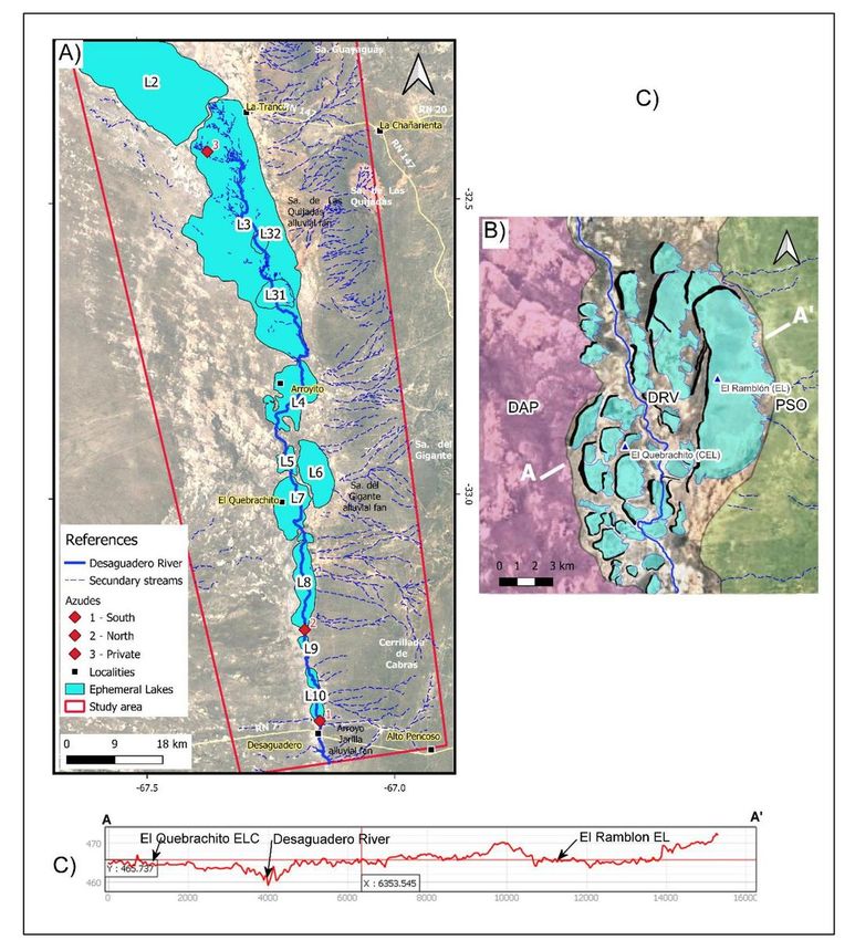
Abstract
The Desaguadero River comprises the upper section of a major hydrological system called Desaguadero-
Salado-Chadileuvú-Curacó, located in the central-western sector of Argentina, on the eastern edge of the
Diagonal Árida Sudamericana climatic belt. Within this basin, extensive wetlands have developed at the
confluence of two main Andean rivers, the Mendoza and San Juan rivers, and from the surface flows
generated during floods associated with the mountain ice and snow melts on the catchment area. The
water from these rivers was channeled along the Desaguadero river, a north-south approximately 150 km
long channel.

This paper proposed the Desaguadero river wetlands as a product of co-development of ephemeral lakes
and lunettes dunes, based on geomorphological surveying and field work supported by stratigraphical
analyses of relict lake-shores and fluvial sedimentary deposits along with historical climatic data. The
morphodynamic activity of these wetlands gradually decreased since the end of the 19th century until
practically disappeared in the 20th century, due to both natural and anthropic causes.

1. Introduction
Globally, 87% of the wetland resources has been lost since 1700 CE, with an increase in loss rates in the
late 20th century (Davidson 2014). The remaining wetlands are being lost three times faster than natural
forests as a result of direct and indirect human impacts, including agricultural conversion, river flow
regulation, groundwater abstraction, invasive species and climate change (Tooth et al. 2021).

Wetlands are determined by a particular geomorphological environment and by lithologic and edaphic
features that allow their location and guarantee the constant or temporary presence of surface or
subsurface water (Kandus and Minotti 2019). About 46% of those wetlands corresponds to the inland
wetland areas of seasonally inundated type (Davidson 2014, Davidson and Finlayson 2018).

In Argentina, wetlands cover a large surface area and include a broad range of types. Kandus et al. (2008)
has pointed out that until a few decades ago, most wetlands were undisturbed by human activities
(except for those in urban areas), such as water use for irrigation, dam building, drainage for agriculture
or peat extraction. One of the best known wetland system in the country is the so called “Lagunas de
Guanacache, Desaguadero y del Bebedero”. It was designated as RAMSAR site in 2007
(https://rsis.ramsar.org/es/ris/1012) and includes a long system of linked lakes and marshes that covers
an area of aproximately 962.370 ha. along the of Mendoza, San Juan and San Luis provinces. The
Desaguadero River wetlands have been experiencing draining problems, similar to those worldwide. The
morphodynamic activity of these wetlands, with fluvio-palustre features, has been decreasing since the
end of the 19th century and all along the 20th century (Gez 1938, Vitali 1940, González Díaz 1981, Suvires
1984, Cazenave 2015, among others), due to natural and anthropogenic causes. The last biggest rise of
the Desaguadero River and development of ephemeral lakes occurred at the end of the last century during

                                                  Page 2/37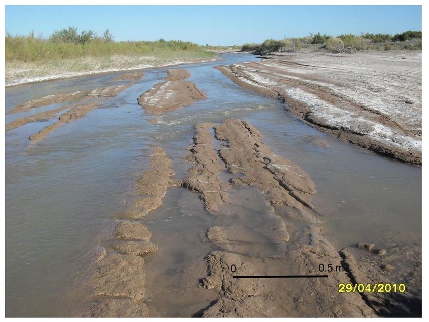
the 1987-1988 summer (Ojeda et al. 2013). Since then, scarce flows at this fluvial system have come
mainly from local summer rains.

The decrease of allochthonous flows, because of ice melt, and the loss of functionality of the ephemeral
lakes contributed to the valley river incision and valley deepening upstream because of headward
erosion (Gez 1938, Vitali 1940, Rodríguez 1966, González Díaz 1981). This condition caused changes in
the local base levels of the Desaguadero River sub-basins, favoring the development of erosive
morphodynamic conditions with the development of rills and gullies in the river’s banks (Ojeda et al.
2012). Ecological studies in the region have emphasized the headward erosion problem in the Lagunas
de Guanacache, in the upper Desaguadero River (Sosa and Guevara 2017).

With the aim of reducing the impacts of erosive processes and partially restoring the desiccated
wetlands, two small-sized dams (locally known as “azudes”) were built in San Luis in 2014 by the local
government, in addition to an azud made by a private individual in the Mendoza’s reach of the river.

Benzaquén et al. (2017) include the wetlands of the Desaguadero River as being part of the wetland
regions of the Monte Central. Sosa and Guevara (2017) have described the ecological characteristics of
this region and have emphasized the headward erosion problem in the in the Lagunas de Guanacache.

According to Fryirs and Brierly (2013), insights from fluvial geomorphology provide an understanding of
physical processes that create, maintain, enhance or destroy riverine habitat (i.e. the physical space that
flora and fauna inhabit). However, as Tooth et al. (2015) affirm, despite its demonstrated relevance, the
contribution of geomorphology for the study of wetlands has been limited. Then, with the intention of
achieving an integral understanding of the role and relevance of wetlands, and in order to support their
effective function from the environmental point of view, it is important to know their genesis and the
factors controlling their development. In this regards, we present the results of the morphostratigraphic
and morphodynamic studies on the wetlands of the upper-middle-reaches of the Desaguadero River. We
propose a model to explain its origin and spatial and temporal development from the Late Pleistocene to
the present. Also, we intend to predict the possible evolution of the system under different types of
environmental pressures.

2. Study Area
The Desaguadero River is located in the arid-semiarid central-west region of Argentina. It comprises the
upper reaches of a highest hydrologic system called Desaguadero-Salado-Chadileuvú-Curacó, with a
basin of approximately 360,000 km2 (Bereciartua et al. 2009, González 2016); and flowing into the
Colorado River basin (Fig. 1). The area under study covers the upper-middle section of the Desaguadero
River, from near La Tranca locality (32°21'4.12"S, 67°16'59.77”; San Juan province), a few kilometers
away from the entrance of the San Juan river into the Lagunas de San Miguel or del Rosario, to the bridge
on National Route N°7 and influence area of the Arroyo Jarilla (33°23'19.22"S, 67° 8'51.76"O, San Luis)
(Fig 1). The main course extends with a length of about 154 km in the north-south direction following a

                                                  Page 3/37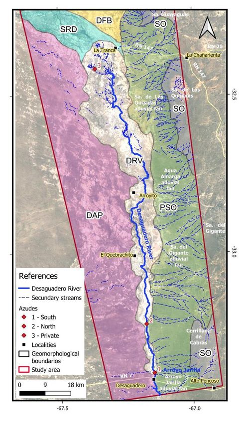
wide tectonic depression, located between the distal piedmont of the Andean Precordillera, on the west,
and the piedmont of the Serranías Occidentales range on the east (San Luis province). The courses of the
San Juan, Bermejo and Desaguadero rivers are controlled by a series of faults, forming a complex with N
80ºW (San Juan River) to N 10ºW (Bermejo and Desaguadero rivers) main directions.

The general relief of the study area (6.457,5 km2) can be described as a plain with a southward slope,
with internal relief lower than 2 m, which in some sectors can reach elevations of up to 14 m in dune
accumulations, and depressions of up to 6 m due to the valley deepening of the Desaguadero river.

Historically, ephemeral lakes, known as Lagunas de Guanacache (or Huanacache according to Vitali,
1940), developed in the confluence of the Mendoza and San Juan Rivers (32° 3'28.17"S, 68°22'21.13"W.),
the flows from these rivers caused surface overflows flooding the low lands towards the south east, in
the tripartite limit between the provinces of Mendoza, San Juan and San Luis (Gez 1938) (Fig. 1).

Climatically, the Desaguadero River is located in the eastern border of the South American Arid Diagonal
(Bruniard 1982), showing in Argentina the contact between the mediterranean influences of the Pacific
anticyclone and the (quasi) monsoon ones of the Atlantic ocean in the Andean belt area (Martínez
Carretero 2013). A common feature in the region is the development of an allochthonous drainage
network in a region with precipitations lower than 300 mm annually (Cazenave 2015). The climate
conditions on the area depend on the scarce rains from the South American Monsoon System (Garreud et
al. 2009), with a main allochthonous source of humidity from the westerlies, e.g. the South Pacific
Anticyclone (Vera et al. 2006). Besides, in warm periods, the most intense influence of the Atlantic
Anticyclone, modulated by the Low Level Jet (Antico and Berri 2004), causes rains which produce an
increase in the mantiform channelized overflow, generating edaphic horizons in the plains with vegetation
in expansion (Chiesa et al. 2015).

Rainfalls are generally torrential and are concentrated in the humid season between November and
March (spring-summer), when about 80% of the total precipitation is recorded (Fig. 2). The average
annual precipitation measured in the La Tranca meteorological station (REM 2021) was of 300 ± 92 mm
for the 2020-2021 period. In the Desaguadero meteorological station (REM 2021), the last 10 years
average values have been 277 ± 108 mm/year. Both stations show maximal rainfall intensities of 37 to
42 mm/h during summers (Fig 2). The average annual temperatures vary between 24,4° C for the
warmest month (January) and 9,2°C for the coldest month (July) (Peña Zubiate and d´Hiriart 2007),
favoring an elevated evapotranspiration (Fig. 2). The average annual evapotranspiration varies between
256 and 293 mm, which explains the scarce availability of surface water during along the year (Trabucco
and Zomer, 2009).

The aridity index of the study area varies between 0.13 and 0.20, which allows to classify the region as
Arid. This classification is based UNEP aridity index, on the rainfall and evapotranspiration values
corresponding to the 1970-2020 period from the Worlclim.org database (Fick & Hijmans 2017), and on

                                                 Page 4/37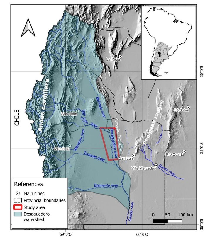
the calculus from the Global Aridity Index (Global-Aridity) of the CGIAR CSI consortium for spatial
information (https://cgiarcsi.community/) (Zommer et al. 2007).

The wind regime is featured by average wind speeds were of 16 ± 6,5 km/h with maximal values of up to
52,2 km/h, 2020 to May 2021 data from La Tranca meteorological station; REM 2021). Dominant winds,
with highest intensities and frequency, comes from the East and Northeast (Fig. 3).

The soils in the aluvial plains and fluvial terraces of the Desaguadero River are higly saline and
calcareous, with a silty sand texture, light yellowish brown according to Munsell soil color chart. The
dominating hydrological deficit, the sedimentary structures and chemical contents condition the
development of soils characterized as poorly evolved, most of them classified as Entisols , with organic
matter contents lower than 1% (Peña Zubiate and d´Hiriart 2007).

The vegetation is abundant on the west piedmont of the Serranías Occidentales where the shrubs and
leafless prickly low forest of the Chaqueño Domine . In the riverside, the halophytic vegetation is
dominant, expanding and mixing with xerophilous vegetation, with Atriplex spp. (cachiyuyos or zampa)
Suaedadivaricata (jume) and Allenrolfeavaginata (vidriera) as the most common plants (Peña Zubiate et
al. 1998). On the right margin of the Desaguadero River, on the province of Mendoza, the vegetation
density decreases significantly, with halophilous and xerophilous forest with abundance of Prosopis
flexuosa (algarrobo), Atriplex lampa (zampa ), Lyciumchilense (llaullín), Tricomaria usillo (usillo) and
Allenrolfeavaginata (vidriera ) (Lagos Silnik et al. 2011).

3. Geological And Geomorphological Background
The first studies on the Desaguadero River were carried out by Gez (1938) and Vitali (1940) who
described the river environment and the ephemeral lake systems, and the hydrology, respectively .
Paleogeographic studies indicate that in the past, the De Zonda river (nowadays Cañada de Moyano)
was formed by the Mendoza and Tunuyán rivers and constituted an important component of the
Desaguadero river system (Rodríguez 1966). However, both tributaries were diverted by avulsion and/or
tectonic processes, and they took different courses until reaching their current position (Rodríguez 1966,
Ortiz et al. 1977, Martínez et al. 2008).

The morphostructural limit of the Serranías Occidentales, known as Bermejo-Desaguadero lineament,
continuous to the south as the known Giant Fault that can be identified in El Gigante, Las Quijadas and
Cantantal-Guayaguas hills (Costa et al. 2001). The fault might be responsible for the basement uplifting
and the deformation of the sedimentary cover by the Cenozoic tectonic inversion of the extensional
basins (Gardini et al. 1996, Costa et al.1999, Gardini et al. 2006). In the study area, this tectonic context is
represented by the asymmetric Las Cabras anticline, whose western margin is constituted by the
mentioned fault (Costa et al. 1995, Gardini et al. 1995, Schmidt et al. 1995, Gardini et al. 1996). González
Díaz (1981) described the “Western depression and environment of the Desaguadero-Salado basin” unit,
emphasizing that natural causes such as the Pleistocene climate changes and other anthropogenic
changes have influenced the development of this big morphostructural element. He also pointed out the
                                                   Page 5/37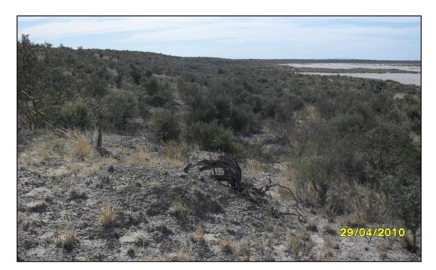
headward erosion process which caused the deepening of the valley near the Silverio lake and the
presence of two terrace levels marked by aggradation and erosion processes.

The antecedents linked to the paleoclimate and paleoenvironmental frame, in which the Quaternary
deposits of the central-west of San Luis are originated, were studied by Piovano et al. (F2009) who
suggest dominantly wet conditions during cold phases in regions located west and south of the AD, with
a dominant Pacific source of moisture. During the same climate phase, dry conditions have been
proposed across the sub-tropical lowlands east of the AD, under the influence of an Atlantic summer
precipitation regime. Conversely, extensive dryness across Patagonia and wet conditions in the Pampas
can be inferred during warm climate phases.

Iriondo (2010) has emphasized that the Desaguadero River was the fluvial collector of the Central Andes
Rivers along the Quaternary, and constituted the main transport system of the clastic and chemical
sediments of the region towards the Atlantic Ocean, although nowadays the system behaves as an
endorheic basin. He has also pointed out that although the flows have currently decreased, there are
sedimentary and geomorphologic elements, indicating that there were periods, especially during the Early
Pleistocene, when the river flow was similar to the present flow of the Paraná River, a main river in the
east of Argentina.

Considering the stratigraphic and paleoenvironmental studies on the area, it can be affirmed that the
wetlands associated to the Desaguadero River have been present in the region since the Late Pleistocene
(Chiesa et al. 2015). The maps elaborated by Ximenez Inguanzo in 1789 (Gez 1938) confirm their
existence during that period. Archaeological studies indicate that the prehispanic populations (huarpes
ethnic groups) inhabited the area at least during three main occupation periods, 1600-600, 600-400 and
200-100 years BP (Chiavazza 1999, 2001, Chiavazza and Prieto 2004, Prieto and Chiavazza 2007). Their
economy was based on fishing and the use of ancient lakes in the region; fishing sites of the native
people were maintained until 400 years BP (Chiavazza and Pietro 2008). Beside, an intense fishing
activity during the first half of the 20th century can be recorded from conversations with local people
while carrying out the present study. The presence of goat manure in the surface of old farmyards,
nowadays covered by dunes, is also a sign of a considerable dry trend in the second half of the century.

The oldest deposits in the banks of the Desaguadero River were included into the Arco del Desaguadero
Formation by Rodríguez and Barton (1993), suggesting a Lujanense mammal age (Late Pleistocene) and
Platense age (Holocene). Chiesa et al. (2015) determined through an absolute dating the Pleistocene-
Holocene limit in the deposits of the Desaguadero River (9580±120 14C 11091-10687 Calibrated Age).
After that and considering the lithological characteristics and altitude of the Desaguadero River and the
Bebedero saline lake depression, Chiesa et al. (2015) proposed the division of the Arco del Desaguadero
Formation into three units of lower stratigraphic category (Members).

4. Materials And Methods

                                                 Page 6/37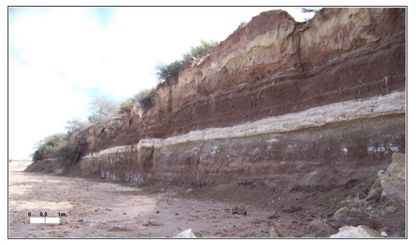
The geomorphological units, including details of lakes and dunes, were delimited based on the
interpretation of satellite imagery of high spatial resolution provided by GoogleEarth ©, and hillshade
images generated from Digital Elevation Models (DEM), and on screen digitized trough QGIS GIS. The
DEMs used (MDE-Ar v2.0), with 30 m of spatial resolution and -2 ± 4 m of vertical resolution, were
provided by the Instituto Geográfico Nacional online database (IGN 2019). This MDE was also used to
obtain morphometric data such as slope and relative heights. The digitizing and general processing of
imagery data were processed by means of the Geographic Information System QGIS 3.4©.

The lithology of geomorphological units was characterized by means of stratigraphic profiles performed
during the field work on the walls of incised alluvial deposit by the ephemeral streams carried out in
numerous campaigns since 2010. The rock and sediment samples collected at field were described and
processed in the laboratory of Universidad Nacional de San Luis in order to determine their granulometric
characteristics by means of mechanical dry granulometric separation and the Bouyoucos hydrometer
method for the finest particles. These mesh apertures correspond to the boundary of the Udden
Wentworth scale.

5. Lithostratigraphic Units And Palaeoenvironments And Of The
Desaguadero River
The wide tectonic depression developed between the Serranías Occidentales of San Luis and the distal
foothills of the Andean Precordillera, constituted a fluvial depositional environment during the Neogene.
This generated the relatively impermeable substrate characterized by ripples that have been recognized in
the current riverbed, which are preliminarily attributed to paleo mega-undulations with a wavelength of 50
cm and an amplitude of 20-30 cm (Fig. 4). Overlay the Quaternary fluvial and lake sediments (Arco del
Desaguadero Formation) and the layer associated with the Holocene aeolian deposits rest. In the study
area, the most outstanding paleoenvironmental features are observed in the outcrops found in the
Desaguadero banks, where sediments of moderate to low intensity are observed, associated with fluvial
flows and decanting processes in lake bodies, for a time span comprising the last ca. 25,000 years
(Chiesa et al. 2015).

In both works, the authors detail the development of the lake deposits considering their stratigraphy and
presence of paleobiota, and refer the basal strata to the Lujanense mammalian age (Upper Pleistocene)
and the overlying strata to the Platense (Holocene) (Pascual and Bondesio 1981). They also point out
that the strata exposed in the banks of the Desaguadero River show the great development reached by
the lake bodies from the north of the Desaguadero town and whose deposits cover the Pleistocene strata
linked to the distal piedmont of the Serranías Occidentales.

Chiesa et al. (2015) propose to extend the area of the outcrops and divide the Arco del Desaguadero
Formation into three units, the lower one called Salina del Bebedero Member with fluvial sand deposits in
the Desaguadero River and sandy conglomerates of the paleocoast of the Bebedero Lake, assigning the

                                                 Page 7/37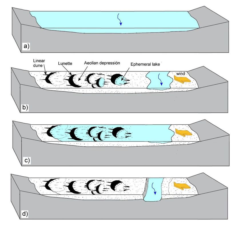
succession to the Upper Pleistocene and highlighting the strong presence of gastropods and bivalves in
the lake body (Font et al. 2014).

In the valley of the Desaguadero River, the deposits of the Desaguadero River Member predominate,
which partly integrate the cut and fill profile with fluvial and lake deposits associated with the
Desaguadero paleo-river and associated lakes. It consists of silty sandstones and sandy siltstones, with a
laminated and massive structure, thin layers of settling and linked to an environment of low-intensity
fluvial interaction and expansion of lake bodies. In this unit, Rojo et al. (2012) identified an important
palynological and gastropod association linked to the Hypsithermal stage or Climatic Anomaly of the
mid-Holocene (Font and Chiesa 2015).

The dates and biological records allow us to assign the lower and middle Holocene to this stratigraphic
unit and indicate that they correspond to a maximum of flows and lake expansion (ca. 12,000 years),
from which point it begins to decrease until the limit with the upper Holocene. At the base of this unit
there is a white, laminated stratum of carbonate and gypsum, indicative of sedimentation under
ephemeral lake conditions (Fig. 5). Also, in different sectors, sediments interbedding is identified from
light green and reddish brown colors, denoting the variability of the water level in the lake bodies, as well
as its fluvial contribution. Generally, the entire sequence has a high saline content and the presence of
laminae, rosettes and concretions of gypsum can be recognized.

Field data, particularly from the stratigraphic relationships observed in the Arroyo Jarilla banks, a
tributary of the Desaguadero River, allow us to estimate that the predecessor course to the current
Desaguadero River was approximately 3 km wide.

The cuspidal sedimentary record corresponds to the Dos Anclas Member, assigned to the upper Holocene
and in which shallow river, lake and saline deposits are identified, as well as eolian deposits of the
floodplain. In this unit, the reduction of the lake bodies stands out, in particular the decrease in the flow of
the Desaguadero river that caused the transformation of the Bebedero lake into the current saline body,
where a salt production company is established; likewise, the retraction of the lakes in the valley of the
river course is evident where the lake floors are exposed and which appear as sandy salt mudstones
(Chiesa et al. 2010).

6. Current Geomorphological Features At The Desaguadero River
In the piedmont and alluvial plain areas that make up the study area, 5 main sub-environments were
identified (Fig. 6): Distal Andean Piedmont (DAP), Desaguadero River Valley and associated lake systems
(DRV), Western Piedmont of the Serranías Occidentales (PSO), San Juan River spill zone (SRD) and Dune
fields of the old Bermejo River alluvial plain (DBF). The units of mountains corresponding to the Serranías
Occidentales (SO) range present in the study area, are identified in the map in Figure 6 but are not
described in this contribution.

                                                   Page 8/37
A notable general feature of the area of interest is the great difference between the western sector (DAP)
and eastern sector (PSO) with respect to the Desaguadero River Valley (DRV), both in drainage density,
vegetation, and in the dominant geoforms and/or geomorphological associations.

The marginal subunits of the Desaguadero River Valley and the associated lake systems are first briefly
described in order to be further described later for the Desaguadero River system.

Distal Andean Piedmont (DAP)
This subunit is part of an extensive morphological unit that Polanski (1952) called “Gran Llanura de la
Travesía” and which forms a wide sedimentation basin along the orographic blocks parallel to the
Precordillera, the Cordillera Frontal and the Macizo de San Rafael, in the west, and the Sierras de San Luis
(Sierras Pampeanas Occidentales), in the east (Abraham and Prieto 1981).

In the analyzed area the most outstanding geomorphological features are the dune fields, the sand beds
and the deflation and temporary waterlogging surfaces, all of them associated with the old spills of the
Tunuyán and Mendoza rivers (Ojeda et al. 2013). The latter suffered the displacement of their main
course associated with avulsion and/or tectonism processes (Ortíz et al.1977, Martinez et al. 2008) until
they reached their current position.

The relief is characterized by a very gentle slope to the east, variable between 0.02 and 0.05 %, with
internal slopes that generally do not exceed 3 m in height, associated with the presence of lunettes and
longitudinal dunes. Surrounding the dunes and the temporary deflation and waterlogging surfaces, there
are also medanous accumulations (sandy geoforms with no defined shape) and thin sandy layers that, in
general, do not exceed 1m in thickness. Except for localized sectors, the dune geoforms are highly
immobilized due to the fixation of the deposit by plant colonization.

The temporary deflation and waterlogging surfaces form units with a flat bottom and a slight slope
against the regional slope, developed on reddish sandy siltstones. They are completely devoid of
vegetation so they are often informally referred to as "peladales" and are easily distinguishable in satellite
images due to their light shades. González Díaz and Fauqué (1993) pointed out that these areas are
locally referred to as “ramblones”, whereas, due to their occasional flooding by rainwater or river
overflows, they are also known as “bañados” or “barreales” (Costa et al. 2001).

Western Piedmont of the Serranías Occidentales (PSO)
It comprises a foothill strip with variable widths between 5 and 20 km, located at the foot of the
elevations of the Serranías Occidentales (González Díaz 1981) whose elevations include, from south to
north, the Cerrillada de las Cabras (768 m.a.s.l.), the Sierra de El Gigante (1140.8 m.a.s.l.), the S ierra de
las Quijadas (1069.8 m.a.s.l.) and the sierras of Guayaguas (830 m.a.s.l.), Cantantal (892.7 m.a.s.l.) and
Alto Pencoso (670 m.a.s.l.) (Fig. 6).
                                                   Page 9/37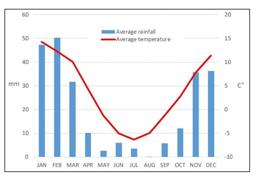
This piedmont unit is made up of different aggradation levels that, from its middle and distal sectors,
form a gentle piedmont descent with slopes of 4% in the proximal sectors and 0.24% in the distal ones.
These are overlain by large alluvial fans, such as the one on Cerro Cantantal (43 km2), Sierra de las
Quijadas (21 km2), Agua Amarga (104 km2), Sierra de El Gigante (209 km2), Represa del Carmen (107
km2) and Arroyo Jarilla (97.6 km2).

Other prominent geoforms include streams associated with current surface runoff, which can develop
wide flood plains, with values between 200 and 1200 m wide and encasement smaller than 5 m. These
ephemeral courses discharge the sediments transported after the great rains as lobes in the distal foothill
zone and in some sectors invade the environment of the old dried lakes associated with the Desaguadero
River.

Unlike what occurs on the right bank of the Desaguadero River, aeolian geoforms are very scarce, except
in those sectors where recent runoff from foothill streams and alluvial systems that remain dry most of
the time, are remobilized by wind action. In the distal sectors the fluvio-aeolic rework of the foothill
deposits themselves develops sandy layers with thicknesses of 60 cm to 1 m.

Dune Fields of the old Bermejo River alluvial plain (DBF)
The Bermejo River valley has been defined as an extensive sandy intermountain desert (Suvires 1984)
where the Bermejo river converges with the San Juan River in La Tranquita, 7 km north of the town of La
Tranca (Gez 1938). Its waters are turbid, slightly reddish and hardly mixed with the clear waters of the
confluent river. In the sector covered by this study, there are large areas of deflation and temporary
waterlogging, limited on the leeward side by sandy accumulations of the lunette type and with partially
saline floors. In the leeward sectors there are also longitudinal dunes, product of the remobilization of the
sands of the old flooding plain.

The geomorphological pattern is similar to that described for the distal Andean piedmont sub-
environment, where lunettes and longitudinal dunes indicate winds from the E-SE quadrant. The course of
the Bermejo River can be followed in satellite images up to about 30 km north of the spills of the San
Juan River, then it is lost due to the sandy remobilizations of the old alluvial plain.

San Juan River spill Zone (SRD)
It comprises the final reaches of the San Juan River on the tripartite boundary of Mendoza, San Juan and
San Luis provinces. Due to the decrease in river energy because of the low slope, morphologies of spills
and ephemeral lake bodies are developed, locally referred to as Lagunas del Rosario, which integrate the
Guanacache Lake system. Vitale (1940) also referred to them as Bañados de San Miguel and La Tranca.

                                                   Page 10/37
In its south-southeast limits, the transition from non-incised to incised channels can be observed. The
latter are taken as the boundary of the Desaguadero River basin. Satellite images records indicate recent
activity in this subunit until 2017, although with a clear decrease in the surface area involved compared
to that of 1998.
Desaguadero river valley and associated lake systems
(DRV)
González Díaz (1981) characterized the environment of the Desaguadero River as a “ponded river”
constituted by extensive and shallow lakes to the north and with a lower section with salt marshes and
circumstantial ponds.
Due to the practically null contributions of flows from the San Juan River, currently the Desaguadero River
can be classified as a non-permanent course, with a local feeding by seasonal rains that in the last 5
years averaged a value of 250 mm/year, according to the information provided by La Tranca meteorology
station (REM 2021). Likewise, data from the Km 47.3 station (SNIH 2021), located more than 150 km
from the study area in the mountain area on the San Juan River, clearly show how at the beginning of the
twentieth century, maximum flows of 745,000 m3/s were recorded, to then decrease to maximum values
of approximately 400,000 m3/s and finally at 100-200 m3/s towards the end of the century, with a last
outstanding record of 150 m3/s in the year 2008. Finally, the capacity data of the N° 1219 "El Encón"
Station (SNIH 2021), located about 20 km upstream of the current terminal spills of the San Juan River,
indicate values that since 2015 oscillate between only 4 and 8 m3/s (Fig. 7).
In addition to the decrease in ice-snow melting flows from the cordillera, there are water restrictions
associated with the construction of 4 dams (Ullum, Los Caracoles, Punta Negra and Cuesta del Viento)
along the San Juan and Jachal rivers, on San Juan province, of which Punta Negra and Los Caracoles
are for consumptive use (González 2016).
Based on the detailed hydrological mapping using Google Earth © images, the headwater of the
Desaguadero River can be located at the convergence point of a series of incised-channel tributaries
which generate a subdentritic to subrectangular network, located between 1 and 2 km south-southeast of
the terminal sector of the Guanacache complex system of channels and ephemeral lakes.
From the morphological point of view, the Desaguadero River corresponds to a mostly rectilinear course
for the 142 km section included in the study area, with a sinuosity index of 1.28 and a very low
longitudinal slope with frequent values between 0.03 and 0.06%. These characteristics are attributed to
the main control exercised by regional tectonic structures and their location parallel to the direction of the
main landscape geoforms.
The current channel has a variable width of 36±15 m, commonly between 2 and 5 m above the levels of
its former floodplain, including the floor of the former temporary ponds, although in some sectors it can
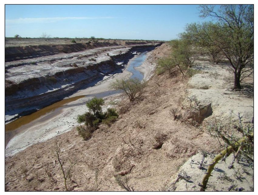
Page 11/37reach 6 to 8 m deep (Fig. 8). The channel bed is represented by thin thicknesses of sandy-loamy
sediments, which partly expose sedimentary rocks referred to the Desaguadero River Member (Chiesa et
al. 2015) of the Arco del Desaguadero Formation (Rodriguez and Barton 1993).
The incision of the main current channel of the Desaguadero River in its former floodplain was pointed
out by Gez (1938) who indicated its main receding headwaters at Salto de Acevedo, about 50 km south
of Laguna Silverio (L3.1), approximately, in the Laguna El Tapón (L8) (Table 1, Fig. 10a). Vitali (1940)
points out that the drying up of the ponds had already been foreseen in 1883; and in 1928 as date of the
incision, they had observed a 2 m drop in the riverbed, in the place where a metal bridge was being built
over the Desaguadero River. Rodríguez (1966) and Chiesa et al. (2010) also suggested a relatively recent
incision of the current channel; the latter are based on radiocarbon dating and the evolution of the
Bebedero paleolake, the local base level of the entire river system (González 1981).
Currently, the headwater associated with the current incised channels is located near La Tranca locality
(San Juan), about 80 km north of the location mentioned by Gez (1938). According to the local residents,
this position was reached after erosive processes temporarily associated with the huge earthquake of
Caucete (San Juan) in 1977. This allows us to approximate an average backward erosion speed of the
main slope of 2 km / year.
From the intersection of the Desaguadero River with the Arroyo Jarilla to the north, there are notoriously
horizontal surfaces, constituted by silt-sandy sediments, by sectors covered with saline precipitates,
corresponding to the floors of the old ephemeral lakes.
The ephemeral lakes are characterized by soils like El Ramblón series (Peña Zubiate y d’ Hiriart 2009),
with little genetic development (A1-ACk-Ck), of dark brown coloration (7.5YR3/4 to 4/4 according to
Munsell Color System), sandy loam texture with abundant calcium carbonate, and belonging to the Order
of Entisols.
The origin of the ephemeral lakes of the Desaguadero River is interpreted as a combination of factors
such as important flood flows during the ice melting season, the low longitudinal gradient of the riverbed
and its floodplain and an impermeable bed (González Díaz 1981; Ojeda et al. 2013). During its active
period, its character was of dominant clastic sedimentation and associated with foothill periglacial river
systems. Even after the important incision of its main riverbed, the seasonal flood flows inundated the
ancient plains and the hydro-aeolian depressions excavated. The last major event was recorded in the
summer of 1987-1988 (Ojeda et al. 2013).
The combination of erosion-wind accumulation processes with the formation of lunettes in the leeward
margins, developed the flood depressions and together with the periodic floods, they shaped their
morphological characteristics and traits.
The floods of Desaguadero River developed systems of chained ephemeral laked, which occupied large
but shallow areas. According to Gez (1938), with the exception of Las Quijadas and Silverio ephemeral
Page 12/37lakes, all other low lands that are covered by floods are shallow embalmed where large masses of cattail
grow.
The dimensions of the bodies decrease noticeably from the headwaters of the river to the south and also
have a variable degree of internal geomorphological complexity. In some areas there were differentiations
in a multiple set of smaller lakes, called here Ephemeral Lake Complexes (ELC), while in others, the
internal complexity is much lower or there is a single body categorized as Ephemeral Lake (LE) (Table 1).
In both cases, the lakes or complexes of ephemeral lakes are limited to the west by lunettes of variable
dimensions, whose maximum heights are reached to the south, such as those associated with Gualén-El
Tapón lake, with maximum slopes of up to 14.7 m (Fig. 9).
In the north of the study area, near La Tranca the so-called "Guanacache Lakes Complex" (L2) begins,
shared by the provinces of Mendoza and San Juan and associated with the dynamics of the San Juan
river. From the sources of Desaguadero River to approximately 50 km downstream and with a maximum
width of 16 km, L3, a complex of ephemeral lakes develops, that contains two main lakes registered as
such in historical maps called Silverio Lake (L3.1) and El Porvenir Lake (L3.2).
Continuing to the south there are smaller lake complexes such as L4 and L5, without specific names so
far. L6 corresponds to El Ramblón, which is characterized by a very saline floor, which some authors call
“Gran Bajo Salitroso” (Peña Zubiate y d’ Hiriart 2009). To the east and southeast of the above is El
Quebrachito (L7), one of the best defined ELC in terms of its internal structure and which will be used as
an example to analyze its evolutionary development. Then, El Gualén - El Tapón (L8), Corral de Tierra (L9)
and South Azud Lake (L10). The latter three have an elongated structure in a north-south direction, large
lunettes on their eastern edges, and a relatively simple internal structure.
Table 1
Ephemeral lakes of the of Desaguadero River (CLE= Ephemeral Lake Complexes; LE= Ephemeral Lake)
Page 13/37Name Other names Surface.
(ha)
L1 ELC Guanacache Lakes Rosario Lake (Province. Of Mendoza and San No data
Juan)
L2 ELC Guanacache Lakes Basin of lakes and reservoirs - Rincón Lake 35393.0
L3 ELC Las Quijadas Silverio Lake (L3.1) 57035.2
Lakes
El Porvenir Lake (L3. 2)
L4 ELC Arroyito - 7787.9
L5 ELC unnamed - 1423.3
L6 LE El Ramblón La Masa Cruz and Los Chosmes Lakes 5672.2
L7 ELC El Quebrachito Quebrachito Lakes 5815.0
L8 LE Gualén - El Tapón Santiago or Salto Lake 5655.2
L9 LE Corral de Tierra - 464.0
L10 LE South Azud Lake - 1962.7
7. Discussion
Framework of the studied system
The development of ephemeral lakes in arid zones has been widely studied. Lees and Cook (1991) have
proposed a conceptual model for the co-development of lakes and lunettes for the coastal environment
on northeast Australia based on field observations and supported by stratigraphical investigation of relict
lake-shore barriers. This model has been applied to shallow lakes (initially 1-2 m deep) subject to strong
uni-directional winds.
According to Shaw and Bryant (2011), the majority of arid and semi-arid regions are characterized by
endorheic (internal) drainage or, in extreme cases, may lack integrated surface drainage altogether. Under
these circumstances, surface depressions become important local and regional foci for the accumulation
of water in episodic (termed here ephemeral) lakes. Furthermore, in some cases, the lakes have lost their
closed status and overflowed at times, as in the Bonneville and Lahontan Lakes of the Great Basin
(Benson et al. 1990)
For smaller ephemeral lakes, lineaments controlling factors as in the Texas High Plain (Osterkamp and
Wood 1987) or linear depressions between longitudinal dunes, as in parts of the Kalahari (Mallick et al.
1981), have been proposed. Erosional processes, such as deflation, are especially important in the
genesis of smaller local or subregional-scale features (Shaw and Bryant 2011). These authors also point
Page 14/37out that deflation has often been cited as an originator or contributor in pan development, e.g. Egypt
(Haynes 1980), the Kalahari (Lancaster 1978a), Australia (Hills 1940; Bowler 1973), Texas (Reeves 1960),
the Argentine Pampas (Tricart 1969) and Zaire (de Ploey 1965).
In relation to the morphology of ephemeral lakes, we can refer to the pan surface morphology as
proposed by Shaw and Bryant (2011). They determined that the shape of the pans are the product of
periodic flooding and desiccation, including: (a) rainfall effects, (b)groundwater depth, brine
concentration and associated crystal growth and dissolution at or near the sediment surface and (c)
aeolian deflation. These authors also reported that given the potential dynamism of these three factors,
surface features themselves are among the most ephemeral of geomorphological phenomena, some
lasting no longer than the interval between one rainfall event and the next.
Koch (2016) has studied the geomorphological characteristics of Lake Torrens and has emphasized the
importance of the studies carried out about the paleoclimates in Australia, particularly on a wide range of
lakes in arid-semiarid climates of the centre-south and centre-south-western areas, such as those of Lake
Frome (Bowler 1986), Lake Gregory (Veth et al. 2009), Lake Mungo (Bowler et al. 2003; Bowler& Price
1998) and Lake Eyre (Magge et al. 2004). However, he has pointed out that there are still questions to be
answered on this subject.
Goudi et al. (2016) have stated the existence of worldwide sites with the presence of big pans,
highlighting that the pans have morphological similarities to those observed in areas like the High Plains
of the USA, South Africa, the Pampas of Argentina and Australia.
The development of dunes derived from the fluvial courses (Source-bordering Aeolian dune formation
along the Scheldt River, Netherlands) during the Younger Dryas has also been studied (Kasse et al. 2020).
One of the most prominent geomorphological elements associated to the ancient ephemeral lakes are the
lunettes. Lunettes are arcuate aeolian landforms (Hills 1940) which occur on the downwind side of many
ephemeral lakes, e.g. in Australia’s lakes (Lees and Cook 1991). These morphologies can be used as key
climatic indicators offering insight into wet and dry phases experienced by the lake (Bowler 1981). Price
and Korniker (1961), Holliday (1997), Price (1963) and Bowler (1973) described these deposits in Texas,
USA, where they identified the source of sediments in the disintegration processes of the fine sediments
of the dry lakes due to the formation of desiccation cracks and the pressure of growth of evaporite
crystals (Arche y Vilas 2001).
The lunettes have been widely recognized in the world, and their importance as a paleoclimate indicator
has been emphasized, such as in Lake Victoria Australia (Chen 1995), Lake Malata-Lake Greenly complex
en Australia (Dutkiewicz and Prescott 1997), High Plains of Texas and New Mexico (Holliday 1997),
Kalahari desert (Lawson and Thomas 1997) and northeast Cape (Marker and Holmes 1995) South Africa.
Morphologically, they are characterized by their half-moon shape and asymmetric transversal
topographic profiles, with the highest slope front towards the wind. Their dimensions are directly related
to the dimensions of the beach or ephemeral lake to which they are associated (Thomas 1988, Holliday
Page 15/371997), and correspond to position dunes with a shape that allows to determine the direction of the wind
that originated them (Pye and Tsoar 2009).
Some of them usually contain high quantities of silt and clay, transported as pellets from the adjacent
beaches during the low water level period. Other dunes are composed almost completely by sand
according to regional hydrologic conditions (Lancaster 1978b, Bowler 1983, Goudie y Thomas 1986).
Bowler (1973) pointed out that they have been attributed to deflation of lake beaches during high lake-
levels, producing quartz sands, and lake-floor deflation during low stands, producing sand composed of
pellets formed by aggregation of silt and clay.
Lees and Cook (1991) have reported the importance or recognizing that the types of lakes under
consideration are very shallow and initially have extremely flat-bed profiles. According to this model, the
lunette formation starts with an initial stage with a persistent uni-directional wind that transfers sufficient
energy to the water surface to generate waves large enough to interact with the lake bed sediments. If
there is a persistent dominant wind, ripples and later sand waves with climbing ripples, will form and
migrate under the action of the wind waves. Tabular cross stratification and bedding typical of combined-
flow ripples will dominate this zone.
In Argentina, the lunette dunes have been described as silt-clay deposits of Pleistocene age in the loessic-
pampean region, and they have been related to the paleo-lentic environments of the Salado Basin in the
province of Buenos Aires (Dangavs 1979; Dangavs y Blasi 1994; Blasi et al. 2010; Fucks et al. 2012).
Archi and Vilas (2001) have identified these geoforms in Tierra del Fuego province; and Mazzoni and
Vázquez (2009) have described limo-clay lunette dunes in the south of Patagonia. Blasi et al. (2010)
have emphasized the salt role as fundamental for the development of saline efflorescence, the absence
of vegetation on the dry platforms, and in the pellets formation. They also highlight the importance of the
hygroscopic character of the resulting pellets, which favor the lunettes stability since they take humidity
from the air and/or the rain (Price 1963).
At the local level, Ojeda et al. (2013) have distinguished lunette dunes related to the paleocosts of
ephemeral lakes associated to the Desaguadero River and developed from the south westerly paleo wind
direction. These geoforms of great magnitude extend for several kilometers, following the undulating
morphology of the lake paleoborders. Their dimensions reach between 60 and 150 m wide, between 3
and 6 m high and a maximum of 14 m in relation to the desiccated floor of the El Tapón ephemeral lake
(33° 5'24.26"S, 67°11'57.21" W).
As regards wetlands, there is still no consensus on a universal definition about them (Brinson 2004;
Kandus 2008). Nevertheless, we follow the definition given by Tooth et al. (2015), who holds that
wetlands are areas that are periodically or continuously flooded by shallow water or have saturated soils,
and where plants grow and other biological activities are adapted to humid conditions.
In relation to the wetlands characteristics, Cowardin et al. (1979) have reported that wetlands are lands
where saturation with water is the dominant factor determining the nature of soil development and the
Page 16/37types of plant and animal communities living in the soil and on its surface. The single feature that most
wetlands share is soil or substrate that is at least periodically saturated with or covered by water. These
authors have also stated that the upland limit of wetland is designated as (1) the boundary between land
with predominantly hydrophytic cover and land with predominantly mesophytic or xerophytic cover; (2)
the boundary between soil that is predominantly hydric and soil that is predominantly nonhydric; or (3) in
the case of wetlands without vegetation or soil, the boundary between land that is flooded or saturated at
some time during the growing season each year and land that is not.
The Ramsar Convention on Wetlands of International Importance (Ramsar 1971) classified the wetlands
in three types: Marine/coastal wetlands; Inland wetlands (with 20 categories) and Human-made
wetlands. Following this proposal, according to Sosa and Vallvé (2004) the Guanacache wetland system
belongs to the Inland wetlands, and because of its characteristics it was included in the categories
codified as: P N Ts W U R Y.
The Class Streambed, according to Cowardin et al. (1979), includes all wetlands contained within the
Intermittent Subsystem of the Riverine System. Water regimes are restricted to irregularly exposed,
regularly flooded, irregularly flooded, seasonally flooded, temporarily flooded, and intermittently flooded.
These authors stated that in most cases streambeds are not vegetated because of the scouring effect of
moving water, but, like Unconsolidated Shores, they may be colonized by "pioneering" annuals or
perennials during periods of low flow or they may have perennial emergents and shrubs that are too
scattered to qualify the area for classification as Emergent.
Historically, wetlands have been associated with hydromorphic, alluvial and halomorphic soils (Shaw and
Fredine 1956). Although the term hydromorphic is used in a wide sense, these soils are usually
associated with temporary or permanent waterlogging or flooding marshes, swamps, peatlands and
generally with gley soils. The alluvial soils correspond with floodplains (Tiner 1999).
Soils featuring these properties reflected in their taxonomy and in cartographic units can be considered
adequate substitutes (proxy data) for delimiting and qualifying the distribution of wetlands over a
territory (Kamdus 2008). In general, wetlands are considered azonal systems due to their dependence on
the hydrologic regime and local geomorphological setting, but in Argentina they show marked regional
variations. In the framework of the Project Evaluation of Wetlands in South America, Canevari et al.
(1998) identified six wetland regions (Kandus 2008).
Morphoestratigraphics and regional paleoclimate
The morphostratigraphic and regional paleoclimate information allows inferring that the Desaguadero
River and the associated ephemeral lake systems would have constituted a wetland area since the
Neogene, favored by the important flood flows coming from the ice melt in the Cordillera and local
conditions of low regional slope on an impermeable hydrological substrate.
Page 17/37The development of the Desaguadero River as a streambed wetland according to the proposal of
Cowardin et al. (1979), would be characterized by an intermittent riverine system water regimes restricted
to seasonally flooded.
Although the general geomorphological characteristics and relationships allow us to determine a
depressed area within a semi-arid to arid region, with water deficit and saline soils, the presence in the
past of ephemeral lakes does not correspond to the typical pan or salt lakes associated with endorheic
depressions, because its upper Cordillera river basin (300 km to the west) during the Pleistocene fed lake
complexes that eventually developed an exorheic system with an outlet to the sea through the Salado-
Chadileuvú-Curacó-Colorado system.
A hydro-wind model is suggested that allows differentiating three main stages in the evolution of a lake
that is intermittently flooded from the river, as well as affected by the wind. Stage 1 comprises the
flooding process and the silt-sand sedimentation of a wide flood plain, during the ice melting period.
Then, stage 2 proceeds with the excavation of deflation depressions related to the strong winds coming
from the E-ENE in the sediments of the floodplain during the dry period, in conjunction with the leeward
formation of lunettes. Stage 3 involves a new seasonal flood, but wind depressions or basins and
lunettes control the floodable areas, resulting in a subdivision of the lake system into smaller ponds (Fig.
11).
During the flood period, the waves on the leeward side of the beach softened the western edge of the
lakes, while the eastern shore was reworked by the wind with the mobilization of sands, occasionally as
longitudinal dunes that generate a festooned design.
While some ELC continued with reduced activity until the end of the last century, other sectors, such as
the El Ramblón lake (L6), the surface was disconnected by avulsion processes and in an over-elevated
position in relation to the already incised bed of the Desaguadero River, thus preventing its new flooding,
making it difficult for it to become a wetland again, even considering flows of the magnitude of the last
great flood or even greater.
Different concurrent factors produce the modification of the relief in the river and lake system; in the
latter, a prominent feature is the desertification causing an intense erosive activity on the edges of the old
lakes. Also, the incision of the riverbed due to the decrease of the local base level, with low flow and
exposing the floodplains for long periods. While, on the eastern edge of the basin, the deposition of fine
sediments occurs by terminal spills of the foothill streams in the former levels of lake and floodplain
floors.
8. Conclusions
The wetlands associated with the Desaguadero River have existed since historical times, favored by
regional climatic and local geological conditions. This period of fluvial and lake activity reduced until its
almost total paralysis, during the end of the last century. The main causes of this fluvial system and
Page 18/37wetlands condition are natural (global warming) and anthropic (construction of dams for irrigation)
impacts in the basin.
The morphodynamic and geomorphological features of the wetland areas correspond to ephemeral lakes
(LE) and ephemeral lake complexes (ELC), where wind activity plays a major role in the process of
subdivision and geomorphological modeling of the area, representing a hydro-eolian process in a purely
continental environment, with the concomitant development of ephemeral lakes and lunettes during
flooding stages and strong bi-directional winds from E and ENE.
Desertification associated with the loss of the wetland dynamics, feed by allochthonous water sources, of
the Desaguadero river reach analyzed is considered irreversible in the medium and short term according
to the global warming trends established as per IPCC (2014), and even in a possible reversion if we
consider the use of water for irrigation in the upper basin by means of the dams.
The incision of the main channel of the Desaguadero River deactivated topographically floodable areas,
so that even in the event of high flow conditions, it seems very unlikely that they would return to their
former condition of ephemeral lakes. Taking into account the establishment of water reservoirs in the
upper basin of San Juan River, this condition will not be feasible in the near future for the entire area
analyzed.
Since 2014 some of the old wetlands are being partially recovered based on two azudes , the lower or
south azud is located upstream of the mouth of the Arroyo Jarilla in the Desaguadero River, reaching a
reduced depth in an area parallel to the riverbed, while, the upper or northern azud is located upstream of
El Tapón lake (L8 in Fig. 10a) that only seems to be leveling the depression of the current Desaguadero
river channel , without flooding the neighboring lake areas.
The construction of small lakes or azudes allows the partial reactivation of old wetlands, locally reducing
the activity of erosive processes; however, it should be noted that these constructions establish different
ecosystem conditions with permanent lakes, or temporary ones, in case of long droughts.
Declarations
Acknowledgments
To the rural people of the Desaguadero River valley, to the National University of San Luis through Proico
030218 (CyT) and spetial thanks to Adriana Mehl for her critical reading of the manuscript.
Funding:
National University of San Luis through Proico 030218 (CyT)
Page 19/37Conflicts of interest/Competing interests:
Not applicable
Availability of data and material :
Not applicable
Code availability :
Not applicable
References
1. Abraham EM y Prieto M del R (1981) Enfoque diacrónico de los cambios ecológicos y de las
adaptaciones humanas en el NE árido mendocino. Mendoza. Cuadernos del CEIFAR (8): 107 – 139.
2. Antico PL y Berri GJ (2004) La Corriente en Chorro Subtropical Media Mensual en América del Sur.
Meteorológica. Vol. 29 (1-2): 37-45.
3. Arche A, Vilas F (2001) Sedimentos eólicos de grano fino en la Bahía de San Sebastian, Tierra del
Fuego, Argentina. Journal of Iberian Geology 2001, 27: 159-173.
4. Benson LV, Currey DR, Dorn RI, Lajoie KR, Oviatt CG, Robinson SW, Smith GI, Stine S (1990)
Chronology of expansion and contraction of four Great Basin lake systems during the past 35,000
years. Palaeogeography, Palaeoclimatology, Palaeoecology, 78:241–286. ISSN 0031-0182,
https://doi.org/10.1016/0031-0182(90)90217-U.
5. Benzaquén et al. (2017) Inventario de los humedales de Argentina. Sistemas de paisajes de
humedales del Corredor Fluvial Paraná-Paraguay. July 2013. DOI:10.13140/2.1.2654.3683.
Publisher: Secretaría de Ambiente y Desarrollo Sustentable de la Nación. Proyecto GEF 4206 – PNUD
ARG/10/003.ISBN: 978-987-29340-0-2. Projects: Humedales de Argentina. Fluvial wetland
classification in De La Plata Basin (mainly in Argentina).
6. Bereciartua PJ, Antunez N, Manzelli L, López P, Callau Poduje AC (2009) Estudio Integral de La
Cuenca Del Río Desaguadero-Salado-Chadileuvú-Curacó. Tomo II. Universidad de Buenos Aires.
Facultad de Ingeniería. 158p.
7. Blasi A, Castiñeira Latorre C, Del Puerto L, Prieto AR, Fucks E, De Francesco C, Hanson PR, García
Rodriguez F, Huarte R, Carbonari J, Young A, Paleoambientes De La Cuenca Media Del Río Luján
(Buenos Aires, Argentina) Durante el último período glacial (EIO 4-2). Latin American Journal of
Sedimentology and Basin Analysis, vol. 17, núm. 2, agosto-diciembre, 2010, pp. 85-111. Asociación
Argentina de Sedimentología. Buenos Aires, Argentina.
Page 20/37You can also read