Sentient Bikes for Collecting Mobility Traces in Opportunistic Networks
←
→
Page content transcription
If your browser does not render page correctly, please read the page content below
Sentient Bikes for Collecting Mobility Traces in
                            Opportunistic Networks

                                   Marcelo Pias⋆ , Kuang Xu⋆⋄ , Pan Hui† , Jon Crowcroft⋆ ,
                                  Guang-Hua Yang⋄ , Victor O.K. Li⋄ , and Salman Taherian⋆
                                  ⋆
                                      University of Cambridge ⋄ The University of Hong Kong
                                          †
                                            Deutsche Telekom Laboratories/TU-Berlin

ABSTRACT                                                                             driven approach is needed. We motivate our study by proposing the
We study the problem of building low-cost city-wide location track-                  following city-wide social application senarios:
ing systems with the intention to provide a platform for large-scale                 Social networking Exploring encounters.
human mobility data collection. We take the city-bikes as our first                        With the continuous locations of bikes, a cyclist can link up
target, motivated by several social networking applications, and                           with others he passes by, and establish new or strengthen his
choose Cambridge in the UK as our pilot case. We highlight the                             social connections. For example, the positioning system can
main application requirements, discuss the practical design issues,                        be linked to social networking websites such as Facebook
and propose a system architecture based on a hybrid sensor net-                            and Twitter. If the system finds two registered participants in
work.                                                                                      close proximity it updates their status in Facebook. Also, the
                                                                                           positioning system can calculate the participants’ cycled dis-
1. INTRODUCTION                                                                            tances and provide incentives (e.g. virtual credit) for those
                                                                                           who travelled the most in their daily cycling. This enables
   Recent years have seen the proliferation of powerful portable de-
                                                                                           comparisons of travel profiles among friends and other cy-
vices that combined with human mobility enable a new networking
                                                                                           clists.
environment for store-and-forward and hop-by-hop opportunistic
communications within the cities. These opportunistic networks                       Security Bike theft.
are different to the traditional communication networks in which                          The public bike-sharing schemes have been receiving con-
end-to-end communication links are assumed. Hence successful                              siderable attention in Europe. To check out and return a
research and design of mobile communication systems require an                            bike, a user swipes his payment/membership card at the bike
understanding of human mobility, and this requires access to mo-                          stations spread throughout a city. To promote the use of
bility data. However, the largest publicly available human contact                        bikes instead of cars, the programme’s organisers offer af-
traces contain about only 100 sparsely connected nodes. Therefore                         fordable rental to their users. It has been reported, however,
it is imperative to find practical and effective solutions to collect                     that the rental scheme in Paris has run into problems just
large-scale human mobility traces.                                                        18 months after its launch. Over half of the original fleet
   Several bike-sharing schemes (often called community bicy-                             of 15,000 custom-made bicycles have disappeared, and pre-
cle program) have been introduced in some European cities                                 sumed stolen. Since the launch of this scheme nearly all the
(Barcelona, Lyon and Paris1 ). These schemes attracted tens of                            original bicycles have been replaced at a cost of 400 Euros
thousands of subscribers within few months. A cyclist produces far                        each. We hope that there is a practical, city-wide location
less carbon emissions, thus helps to reduce our carbon footprint.                         tracking system that can effectively help authorities tackle
Bicycles are inexpensive when compared to vehicles, and they pro-                         bike theft in community bicycle programs. And if we can
vide a means of physical exercise for their users. Thus, we believe                       build such a system at a low cost (say 10% of the Paris bike
that mobility traces from cyclists would be a valuable resource for                       replacement cost), that would be a step forward.
the research community in mobile systems design.
   Starting from here, we ask the question whether a low-cost loca-                     In this paper we propose a general platform for large-scale col-
tion tracking system for large-scale traffic of city-bikes is possible.              lection of human mobility data with a particular focus on the se-
We would instrument bikes with sensors, and track them continu-                      curity scenario. We want to target a city-wide deployment, with
ously. Despite technical details, a bottom-up practical and privacy-                 low-cost devices, and we do not require high accuracy for the po-
                                                                                     sition. The design of such a system needs a number of considera-
1
    http://en.wikipedia.org/wiki/Community bicycle program.                          tions. There are several possible competing approaches.
                                                                                        The contribution of this paper is a discussion of the practical
                                                                                     problems of deploying a low-cost bike positioning system. We pro-
                                                                                     pose a system architecture that relies on a hybrid sensor network
Permission to make digital or hard copies of all or part of this work for            (an infrastructure with mobile sensor nodes). We advocate that the
personal or classroom use is granted without fee provided that copies are            best approach for us to understand wireless sensor system is build-
not made or distributed for profit or commercial advantage and that copies           ing them (bottom-up practical experimentation). Thus, we take an
bear this notice and the full citation on the first page. To copy otherwise, to      application-driven system design approach that favors simple solu-
republish, to post on servers or to redistribute to lists, requires prior specific   tions to our issues. We share the same view as the one put forward
permission and/or a fee.
ACM HotPlanet ’09 Krakow, Poland.                                                    in [11] where we design systems and protocols for one specific sce-
Copyright 2009 ACM 978-1-60558-689-2 ...$10.00.                                      nario after another, and after a few solutions, we look for generality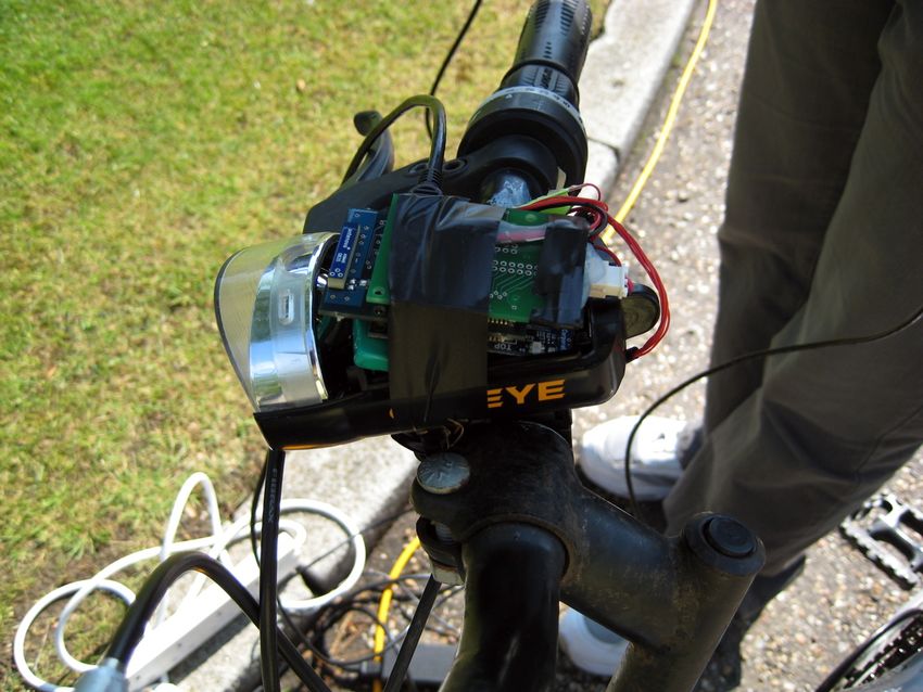
across the specific. The bicycle network of Cambridge (UK) is our            evaluations. They have been analysed mostly in simulations. How-
application domain.                                                          ever, there are a number of practical deployments of location sys-
                                                                             tems that rely on an infrastructure of servers for information ag-
                                                                             gregation and position calculation, and they are mostly limited to
2. APPLICATION REQUIREMENTS                                                  single hop localisation from a set of known access points (APs).
   We choose Cambridge as our city since it has the highest level of         Such approaches improve accuracy, reliability, and dependability
cycling in the UK with one in four residents cycling to work2 . The          of the system.
city-bikes need to be constantly tracked from a central location. We            The wide adoption of WiFi-enabled mobile devices (e.g. smart
equip each of the bikes with a tiny battery-powered sensor device            phones, PDA) and the rapid deployment of WiFi access points
that can collect sufficient data to estimate location. The location          make WiFi localisation attractive. The RADAR project [1] pio-
update rate is in the order of tens of seconds. The bike sensor device       neered indoor WiFi location, using WiFi “fingerprints” previously
needs to continuously send sensor data to back-end servers. The              collected at known locations inside a building to identify the lo-
system requirements are as follow:                                           cation of a user’s device down to 2-3 metres (median accuracy).
                                                                             The fingerprint algorithm assumes that at a location point, a user’s
      • Sensing: location of bikes (e.g WGS84 coordinates) within            WiFi device may receive beacons from different access points with
        a city map should be computed within an accuracy of 50 me-           certain signal strengths; this set of APs and their associated signal
        tres. Inertial MEMS sensors can be integrated to improve the         strength represents a fingerprint that should characterise that po-
        accuracy of location estimates through dead reckoning. Such          sition. The fingerprint algorithm is split into two stages. In the
        sensors can also assist in optimising the system power con-          first, the radio map at different locations are built by using methods
        sumption, for instance, by switching off sensor components           such as war-driving in open spaces, and in the second stage (posi-
        when the bike is not in motion.                                      tion phase), a device performs a scan of its environment, calculates
                                                                             its relative location with regard to the surrounding APs (such as
      • Communication: the network coverage is around 2.5 km x               in [12]), and compares this with its known radio map . The tech-
        2.5 km (Cambridge city centre). The infrastructure should            niques that address the issue of APs that have been deployed after
        have back-end servers, and around 30 fixed nodes. We aim             the war-driving radio mapping are discussed in [3].
        at instrumenting approximately 200 bikes.                               UCSD’s Active Campus project [6] employs WiFi to locate de-
                                                                             vices inside and outside buildings based on a simplistic algorithm
      • Real-time versus data logging: the location is updated
                                                                             that relies on known positions of access points on a university cam-
        every 100 metres for real-time tracking. However, finer-
                                                                             pus. Place Lab [7] introduced wide-area WiFi location, showing a
        grained sensor data should be logged on the device for post-
                                                                             median accuracy ranging between 15 and 60 meters and high cover-
        processing and reliability.
                                                                             age. Place Lab depends on war-driving data collected by a variety
      • Sensor system packaging: small size and compact form fac-            of users as they move naturally throughout a region. Place Lab is
        tor to be fitted on a suitable part of the bike (e.g frame or hub)   intended for use in metropolitan-scale deployment, and it is useful
        or inside the light case.                                            for users with smart devices. But if we want the end devices to be
                                                                             low cost, it may not be an appropriate choice.
      • Battery life: it should last for at least a month on average            The BikeNet project [4] addressed environment monitoring ap-
        commuting journeys (an hour per day). Energy harvesting              plications with various types of sensors attached to bikes. It also
        can be exploited from the bike’s motion (wheel dynamo sys-           studied the sensors for inter-bike networking through data muling.
        tem) to increase battery lifetime.                                   Unlike BikeNet, this work focuses purely on the tracking of objects
                                                                             using scalable and low cost mobile sensor devices. We approach
      • Security: it should provide an effective way to avoid damag-         these issues with a dual-function system, where bikes are tracked
        ing to sensor devices, likely to be the case when addressing         around a city area, and this data communicated wirelessly to an in-
        bike thefts.                                                         frastructure. Bicing is a bicycle-sharing programme in Barcelona.
                                                                             In [5], the authors based on a six-week dataset of observations, in-
      • Cost of the system: Ideally the cost should be around 35 US          troduced a notion that the digital footprints of cyclists could be used
        dollars for a sensor device to be placed on the bike.                to uncover human behavior patterns and city dynamics. However,
                                                                             they do not have information on where the bikes travel between
                                                                             bike stations. Our work provides the system to upload locations
3. RELATED SYSTEMS                                                           of bikes in real time, which serves as complementary data to their
   The most commonly available location technology today is the              work. In addition, this can increase the operational efficiency of
Global Positioning System (GPS). Although accurate and very ef-              bike-sharing programmes and reduce the rate of bike theft.
fective in open environments, GPS alone does not support two-way
data communications, which is required by a tracking application.
We anticipate, however, the use of GPS integrated with wireless
                                                                             4.    THE SENTIENT CITY-BIKE
communication in some of our systems.                                           The Sentient City-Bike system is designed according to an event-
   The city-bike location discussed here concerns mostly outdoor             based layered architecture. City-bike mobile sensor nodes publish
location systems and techniques. Although a number of suitable               event sensor data that are pushed towards trackside servers. The
indoor location systems exist, in this section we discuss only those         sensor data mainly comprises signal strength of WiFi AP beacons.
that employ RF signals in their engine.                                      Inertial sensor data may be collected in selected subsets of sensor
   At first distributed location algorithms (e.g DV-hop [10] and             nodes. This can be used for strapdown inertial navigation tech-
four-stage [14]) seem favourable to our city-wide positioning. But           niques.
the majority of these techniques lack practical deployments and                 To reduce costs, the majority of the mobile node devices have
                                                                             limited processing power, memory and battery lifetime. The track-
2
    Cambridge City Council: http://www.cambridge.gov.uk                      side servers are sufficiently powerful to perform the location es-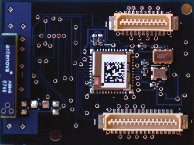
Figure 2: Cambridge Sensor Kit (CSK) WiFi board
Since it has powerful resources, we leave the computation of loca-
tion and other sensor-related analysis to this subsystem. It offers
a web interface to end-users with enhanced map applications. The
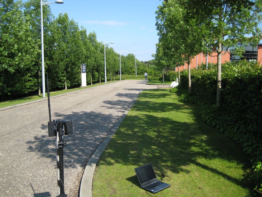
Figure 1: Measurement setup (AP 4000-MR-LR)
server provides web services to make location and sensor derived
information available in social networking websites (Facebook, or
timation by correlating the AP information with the available AP
Twitter for quick location updates).
database using some of the techniques discussed in Section 3. The
system architecture is split into three subsystems: the communica- 4.3 Mobile sensor node
tion infrastructure, the central server, and mobile nodes.
Our system has two types of lightweight and small physical size
4.1 Communication infrastructures nodes. The basic node has essential sensing capabilities. Super
nodes are more powerful devices in terms of processing, sensors
We assume there is a gateway that delivers data wirelessly be-
and memory. We equip a fraction of super nodes (between 15%
tween the bike sensor system and trackside servers on the infras-
and 30%) with GPS receivers and other types of sensors. We se-
tructure. We were presented with a number of industry standard
lect those nodes with potential to be active throughout the coverage
wireless systems (Bluetooth, Zigbee, Wifi). Bluetooth requires de-
area. They should be able to do complementary fingerprint data
vice discovery and connection establishment which causes prob-
collection, so that the AP central database is kept up to date. This
lems for real-time data collection. Zigbee is designed for low power
is an on-going task to complement the initial fingerprint data col-
and low sampling rate (250 Kbps) and short range (up to 30m) ap-
lection as part of an existing infrastrucutre/database. Super nodes
plications. Our practical attempts with ZigBee radio from various
equipped with GPS should also provide additional calibration data
makers failed mostly because of a lack of robustness.
to verify and further improve the accuracy of location information
WiFi is more on the expensive side exhibiting higher power con-
gathered from the other fraction of nodes.
sumption compared to the other two options. But WiFi power con-
The sensor nodes together with lightweight batteries (10 grams)
sumption has improved with recent developments for smart phones
will be placed inside the plastic bike light casing, frame or hub.
(iPhone and Google Android). Manufacturers (e.g. Marvell and
Some of the nodes may include inertial on-board MEMS sensors
Atheros) have developed low power chips, and Gain Span (Intel
(accelerometers, gyroscopes, and magnetometers). Such inertial
spin off) has claimed a WiFi sensor node that can last for years on
data can be fused with WiFi Fingerprint information (basic and
a single AA charge. Of course, this assumes an efficient schedul-
super nodes) and GPS data (super nodes) through an Extended
ing of tasks on the sensor node (sampling, processing, data logging
Kalman Filter (EKF). Techniques similar to the ones employed in
and data transmission). Another benefit of WiFi is its ability to
strapdown inertial navigation systems can be used here to improve
support data communication with an extended range. Data rates of
the accuracy of the location estimates.
54Mbit/s in 802.11a/g and beyond in 802.11n exceed the required
We looked at various WiFi-based sensor systems (GainSpan,
throughput of general tracking system. The extra bandwidth can be
G2 Microsystems) but chose to discuss the Cambridge Sensor Kit
exploited by other applications.
(CSK), and mobile phones as first candidates for mobile nodes.
We consider WiFi Mesh that is a communications network made
up of WiFi radio nodes organised in a mesh topology. Mesh net- 4.3.1 Cambridge Sensor Kit (CSK)
works often consist of clients, routers and gateway. In our system,
The UCAM-WSB100 3 is a low power WiFi-based sensor board
the mobile nodes are the mesh clients, and the infrastructure track-
designed in the Computer Lab (University Cambridge). This board
side nodes form the mesh routers and gateways. Table 1 lists a few
is part of the Cambridge Sensor Kit (CSK) that has been developed
options of mesh routers. We carried out some initial tests to under-
for a sports sensing application 4 . The CSK WSB100 is compati-
stand the communication coverage of a mesh router. We used an
ble with the Crossbow Imote2 processor board. It has a 12-channel
AP4000-MR-LR (24dbm) with 18dbi flat board antenna in an open
ADC and supports 802.11 b/g with power management. We expect
space (Figure 1). The antenna was placed on the roof of a ten-story
the CSK WiFi system to work adequately in our city-bike applica-
building. A remote user carrying a WiFi device was able to watch a
tion. And if customisations are needed they can be made since the
movie in real-time at a distance of 250m, and surf the web at 400m.
CSK hardware design and Linux-based software are open source.
The communication range was 800m between any two mesh back-
We did some preliminary tests to examine the WiFi connectivity
haul router. These preliminary results are encouraging.
of the CSK. The sensor kit was placed in a bicycle light casing,
4.2 Central Server 3
http://imote2-linux.wiki.sourceforge.net/UCAM-WSB100
4
The central server is used for long-term storage and computation. SESAME: http://www.sesame.ucl.ac.uk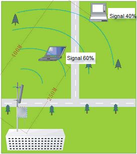
AP Name                        Tx Power                   Rx Sensitivity                               Frequency Band                         Aerial Gain                Price (USD)
 ORiNOCO AP400-MR        20dbm (radius coverage up to 300m)         NA                             2.4G (client) 5.47-5.725G (backhaul)             8/10/18dbi              $800 + $200 (aerial)
  Motorola IAP4300                     27dbm                  -100dBm@1Mbps                            2.4GHz(client and backhaul)                  8/10/18dbi                    $2000

                                                        Table 1: Options of mesh routers

                                                                                                                                         RTT measurements
                                                                                                                          From a laptop to an iPhone (duration of 1.28 hours)

                                                                                                 1200
                                                                                                                                                                                       RTT
                                                                                                                                                                                       y min (3.797 ms)
                                                                                                                                                                                       y max (1072 ms)
                                                                                                 1000                                                                                  y mean (161.9 ms)

                                                                                                 800

                                                                             RTT (in millisec)
                                                                                                 600

                                                                                                 400

                                                                                                 200

                                                                                                   0
                                                                                                    0      500     1000   1500          2000        2500         3000           3500   4000       4500
                                                                                                                                 Sample number (1 ICMP packet/second)

              Figure 3: CSK WiFi Signal Strength                                                                 Figure 5: iPhone RTT measurements.

                                                                                     This suggests the iPhone OS process/task scheduling is giving low
                                                                                     priority to IP protocol processing when the foreground application
                                                                                     is not any network function. We did not observe packet loss within
                                                                                     the 250 metres range. In another experiment we collected data by
                                                                                     running ping from a steady laptop against the iPhone, all connected
                                                                                     to a local basestation. Figure 5 shows the RTT measurements from
                                                                                     a laptop to an iPhone with WLAN for an hour (a sample every
                                                                                     second). The mean RTT was 150 ms, and the difference between
                                                                                     minimum (3 ms) and maximum (1000 ms) is worrying.
                Figure 4: Bike Experiment Setup                                      4.4 WiFi Coverage
and WiFi signal strength measurements were taken as a cyclist ap-
proached and passed a WiFi base station in an urban environment
(Figure 4). In this setup, we used an off-the-shelf D-Link WiFi
AP with a single 9dB antenna, elevated to the 1.2m off the ground.
Figure 3 shows these measurements as the cyclist approached and
passed the base station (located at the zero metre landmark). The
’start’ and ’stop’ labels on the diagram indicate the direction of the
motion. As evident, the WiFi signal strength improves as the cyclist
approaches the base station, and it drops when the cyclist passes the
base station. The rate of increase and decrease in the signal strength
is uneven, as the WiFi signal changes characteristics from line-of-
sight connectivity to non-line-of-sight connectivity. In the former
setting, there is a clear signal path between the base station and
the sensor system (light case facing the base station). Whereas in
the latter setting, the human body blocks and substantially attenu-
ates the main signal propagating from the base station to the CSK
sensor node.
                                                                                                        Figure 6: FON WiFi Access Points in Cambridge
4.3.2 Phone as Mobile Sensor Node                                                       WiFi Fingerprint scheme uses not only public but also private
   Given the fact that almost everybody has a mobile phone, we also                  APs, whenever these are available. The scheme does not require
consider using mobile phone devices as our sensor nodes. The lat-                    proprietary support from the WiFi infrastructure vendors. The ma-
est smartphones (iPhone, Google Android G1) include a number of                      jor effort needed is the war-driving to build a database of known
the sensor systems we discussed above (GPS receivers, accelerom-                     APs and their locations. We expect this work to take a month or so.
eters). It is expected that other types of sensors will be added in                  Cambridge is a University town with a number of residences, and
future phones. We tested an iPhone in the same urban setup as the                    we expect a high density of WiFi APs. Figure 6 shows the FON
one described for the CSK (above). We ping the iPhone from a                         WiFi/AP coverage in Cambridge. We can see that even if we only
laptop. The mean RTT value was around 200 ms at 250 m dis-                           rely on the FON APs, the city is reasonably well covered.
tance. But we observed that when pinging the basestation from the
iPhone the mean RTT dropped to around a sensible value ( 3ms).                       4.5                 Power consumption
Chipset IEEE MAC RX Pw TX Pw Data Rate Energy/bit
Chipcon CC2420 802.15.4 19.6mA x 1.8V ≈ 35.28mW 17.04 mA x 1.8V ≈ 30.67 mW 250 Kbps TX: 122 nJ/bit
Marvell 88W8686 802.11b/g 174.87mA x (1.8 and 3.0V) ≈ 320.61 mW 257.05 mA x (1.8V and 3.0V) ≈ 593.55 mW 11 Mbps TX: 53 nJ/bit
Table 2: Preliminary power measurements
The issue is building a low-cost location system that would not during the morning rush hour in Cambridge. Even if there is rea-
require frequent charges of battery. This poses a challenge to the sonable network bandwidth available (say 54 MBps in 802.11g),
form factor and size of the device since continuous power con- the burst of data may overwhelm the system in such situations.
sumption at high data rates requires a larger battery capacity, which Thus sensor nodes may have to postpone data download to the next
is proportional to battery physical size. WiFi is commonly regarded data collection point simply because the current spot (say an AP
as power hungry. But recent low voltage hardware designs have close to a traffic light) is overwhelmed. To work in this solution
taken the consumption down. space, we require synchronisation of systems across sensor nodes,
The trade-off between data rate, power consumption and com- and infrastructure nodes.
munication range is a key issue to be addressed. We did some
back-of-the-envelope calculations that may be used as an indica- 4.7 Privacy-compliant system design
tion of the power draw for the Marvell 8686 chip used in both CSK We anticipate that there will be a number of technical (system-
and iPhone. We argue that any power consumption (cost) analy- related as discussed above) and non-technical challenges (social
sis should consider the data rate (benefit). Table 2 makes a com- and legal) when a city-wide location system is deployed. This re-
parison between IEEE 802.15.4 and 802.11 based on a metric that quires the expertise from engineers, social scientists and lawyers.
correlates cost/benefit (energy per bit): From a city planner’s view, a location system is likely to serve dif-
ferent purposes, mostly related to the tracking of people and vehi-
P cles in the city so that better facilities and services can be rolled
Ebit = out. Most of such services require collection, storage and process-
b
ing of a huge amount of personal data. This brings the issues of
where P is power consumption and b bit rate. It can be seen that
privacy, data protection and trust - all crucial for the development
the energy per bit for the CC2420 (IEEE 802.15.4) is twice as high
of location-based applications. A central authority has access to the
than the Marvell 8686 (IEEE 802.11 b/g). This is due to the fact that
location information of each individual. This poses an obstacle to
the 802.11 achieves much higher data rates (higher benefit). This
the deployment of such a system as users may be discouraged in
is very conservative because we assume the 802.11 is operating at
taking part [2]. Incentives and privacy measures should be intro-
11 Mbit/s, where it can achieve up to 54 Mbit/s (802.11g). Both
duced to motivate the users. Users should trust our systems, and
systems have similar power budgets while in power down modes.
it is crucial that we make transparent how the user’s data will be
The time cost for switching from the idle to sleeping modes (power
processed and used. Once trust is established, incentives for user
down) is likely to be different though, with higher latencies ex-
adoption of our systems will be introduced with the integration of
pected for the IEEE 802.11 b/g.
user location data to online social networking (e.g. Facebook and
We believe that the real issue is the design of an improved duty
Twitter).
cycle scheme for the sensor node system - a compromise in the
However, we understand that early adoption of privacy issues
scheduling of tasks (sampling, processing, logging, and data trans-
in the design of our low-cost city-wide localisation system should
mission). This issue needs to be further investigated in our practical
be encouraged. Otherwise, later corrections through regulatory
application scenario. In addition, we expect to be able to convert
measures can be expensive to implement. In this context, privacy
some of the mechanical energy from the bike’s motion, and store it
should not be dealt with as an add-on function to the system, e.g.
in the sensor node system [9]. For example, we can put the sensor
by data filtering and minimisation measures. An approach here
in the wheel-hub to make it powered by a dynamo system. Whether
is to take an iterative design with user feedback using the social
this energy will be sufficient to power up our entire system remains
science technique of realised scenarios proposed by Martin et al.
to be investigated.
[8]. Realised scenarios are real technical installations, combined
4.6 Synchronisation of heterogeneous systems with social situations of an application, on a low level of technical
sophistication and social realism. With this technique the users ac-
Data samples collected from the various city-bike sensor nodes
ceptance of different modes of data collection and processing can
should be correlated for either real-time monitoring or post-
be modelled as a give-and-get game. It could be determined what
processing analysis. This brings the issue of synchronisation of
type and amount of sensitive information users are willing to give
different systems. The complexity of the problem tends to increase
to the technical system with respect to the reward they expect to
with strict accuracy requirements. In practical terms, we deal with a
receive. Instead of an overall scepticism towards these technolo-
hybrid wireless network, partly formed by mobile sensor nodes on
gies, this approach could lead to a scaled and more situation-aware
city-bikes that exchange information with infrastructure trackside
analysis, which will not require an overall consensus.
servers. The synchronisation is needed across these heterogeneous
systems for real-time, and post-processing analysis. A number of
time synchronisation protocols for wireless sensor networks have 5. COST AND SECURITY
been proposed in the literature [13]. However we seek simple solu- We want to start with 200 sentient city-bikes instrumented with
tions to synchronise the clocks of the systems relative to a common CSK sensor nodes at unit cost of around US$35, which gives a
reference time (say world time). Time synchronisation will be re- total of US$8,000 in sensor devices. We also plan to use 30 WiFi
quired within 100 ms (10 samples/second sampling). access points that can cover the Cambridge city centre (2.5 km x
We anticipate that sensor data collection should also benefit from 2.5 km). The ORiNOCO AP400-MR AP costsUS$1,000 per unit,
this synchronisation. For instance, data collection may have to be totalling US$30,000. This is a high initial setup cost which is likely
smarter in downloading data from crowds of bicycles, for instance, to be amortised when more bikes are instrumented in this scheme.Another option is to use inexpensive wireless routers (e.g. LinkSys Acknowledgements
WRT54G) at US$50, and 30 routers should bring the cost down We want to thank Jonathan Cameron for his effort in develop-
to US$1,500. Table 3 gives the cost breakdown. In addition to ing Linux device drivers for the CSK WiFi board, and George
the infrastructure, the software development (i.e. mobile sensor Coulouris for his feedback on the wireless sensor system. We are
node, AP, and war-drive) is another considerable cost. However, by also grateful for the comments and suggestions received from the
resorting to the location database of SKYHOOK 5 , this cost item is anonymous reviewers.
negligible.
These figures are independent of the number of bikes. With these
estimates the cost per bike is US$53, which is almost twice of the 7. REFERENCES
intended cost of US$35 as discussed in Section 2. But we expect [1] P. Bahl and V. N. Padmanabhan. RADAR: An in-building
the unit cost to decrease significantly when the system scales up. RF-based user location and tracking system. In IEEE
Nevertheless, US$53 remains a fraction of the 400 Euros cost per INFOCOM (2), pages 775–784, 2000.
bike stolen on the Paris city-bike program. [2] A. R. Beresford and F. Stajano. Location privacy in pervasive
computing. IEEE Pervasive Computing, 2(1):46–55, 2003.
Mobile node with CSK US$8,000 [3] Y.-C. Cheng, Y. Chawathe, A. LaMarca, and J. Krumm.
Infrastructure US$1,500 Accuracy characterization for metropolitan-scale wi-fi
Central server US$600 localization. In Proc. of MobiSys ’05, pages 233–245. ACM,
Basic cost in total US$11,600 2005.
[4] S. B. Eisenman et al. The bikenet mobile sensing system for
Table 3: Cost breakdown cyclist experience mapping. In SenSys ’07, pages 87–101,
For the security of devices and bikes, we plan to install the de- New York, NY, USA, 2007. ACM.
vice inside the hub of the bike’s wheel, making it sufficiently hard [5] J. Froehlich, J. Neumann, and N. Oliver. Measuring the pulse
to remove without damaging the bike. Below we discuss several of the city through shared bicycle programs. In Proc. of
options to secure bikes against thefts: UrbanSense08, November 2008.
[6] B. G. Griswold et al. Using mobile technology to create
• For the bike-sharing scheme, most systems require a user to opportunistic interaction on a university campus. In
return a bike to a well-known place (e.g. bike kiosk). We Proceedings of UBICOMP Workshop on Supporting
can place a software-triggered alarm in the server or in the Spontaneous Interaction in Ubiquitous Computing Settings,
WiFi APs nearby. If the user cycles outside an area of normal Munich, Germany, 2002.
cycling the alarm is fired and the system reports the latest [7] A. LaMarca et al. Place lab: Device positioning using radio
known location. beacons in the wild. In Proceedings of PERVASIVE 2005,
Munich, Germany, 2005.
• Thieves typically take bikes somewhere to remove various [8] M. Meister et al. Application scenarios for cooperation
distinctive markers for re-selling. The system may provide objects and their social, legal and ethical challenges. In Proc.
hints to the location of such professional thieves’ garages. of the First International Conference on the Internet of
This information may assist the police authorities in reaching Things, pages 92–97, 2008.
those places. [9] P. Mitcheson, E. Yeatman, G. Rao, A. Holmes, and T. Green.
Energy harvesting from human and machine motion for
• The tracking device can be linked to distance or time-based wireless electronic devices. Proceedings of IEEE,
charging for instance, via surcharging a credit card if a mali- 96(9):1457–1486, Sept 2008.
cious user wants the bike to go more than a short way within
[10] D. Niculescu and B. Nath. Ad hoc positioning system (APS).
a short time, then the bill can be set prohibitive. In a stronger
In Proc. of IEEE GLOBECOM, 2001.
approach for this situation, it is interesting to instrument a
bike with a immobilizer controlled by the tracking device, to [11] B. Raman and C. K. Censor networks: A critique of ”sensor
keep the bike from further proceeding. networks” from a systems perspective. ACM SIGCOMM
Computer Communication Review, 38(3):75–78, July 2008.
[12] J. Rekimoto, T. Miyaki, and T. Ishizawa. LifeTag:
6. CONCLUSIONS WiFi-based continuous location logging for life pattern
In this paper we made an attempt to discuss the design issues analysis. Lecture Notes in Computer Science, 4718:35, 2007.
for practically experimenting with a location tracking system - the [13] K. Romer, P. Blum, and L. Meier. Handbook of sensor
Sentient City-Bike. We looked at our city-bike application require- networks: algorithms and architectures, chapter Time
ments, and discussed some of the key design choices and compet- synchronization and calibration in wireless sensor networks,
ing solutions. We favour a hybrid sensor network, with mobile sen- pages 199–237. Wiley and Sons, 2005.
sor nodes communicating with track-side servers. Low power WiFi [14] C. Savarese, J. Rabaey, and K. Langendoen. Robust
with optimised power management serves dual-function in our ap- positioning algorithms for distributed ad-hoc wireless sensor
proach: location tracking and data communication. We also pro- networks. In USENIX Technical Annual Conference, pages
posed potential social networking applications to engage large par- 317–327, 2001.
ticipation of users. Although application-driven research requires
time and money for prototyping and data collection, we argue that
large-scale mobility traces collection is a premise for successful re-
search, design, and building of mobile systems.
5
SKYHOOK, http://www.skyhookwireless.com/, provides public
APIs to access its location database.You can also read