DEMONSTRATION OF FOUR OPERATING CAPABILITIES TO ENABLE A SMALL AIRCRAFT TRANSPORTATION SYSTEM - NTRS
←
→
Page content transcription
If your browser does not render page correctly, please read the page content below
https://ntrs.nasa.gov/search.jsp?R=20050237879 2020-05-04T09:00:00+00:00Z

  DEMONSTRATION OF FOUR OPERATING CAPABILITIES TO ENABLE A
          SMALL AIRCRAFT TRANSPORTATION SYSTEM
                     Sally A. Viken, NASA Langley Research Center, Hampton, VA
             Frederick M. Brooks, National Consortium for Aviation Mobility, Hampton, VA

Abstract                                                      major/hub airports, 41% live within 30 minutes of
                                                              any commercial airport, and 94% within 30 minutes
      The Small Aircraft Transportation System
                                                              of small community airports [3]. One solution to
(SATS) project has been a five-year effort fostering
                                                              increasing mobility in our nation’s transportation
research and development that could lead to the
                                                              system is to exploit the abundant small community
transformation of our country’s air transportation
                                                              airports across the country [1] (Figure 1).
system. It has become evident that our commercial
air transportation system is reaching its peak in
terms of capacity, with numerous delays in the
system and the demand keeps steadily increasing.
The SATS vision is to increase mobility in our
nation’s transportation system by expanding access
to more than 3400 small community airports that
are currently under-utilized.
     The SATS project has focused its efforts on
four key operating capabilities that have addressed
new emerging technologies and procedures to pave
the way for a new way of air travel. The four key                 Figure 1. More than 3400 SATS Capable
operating capabilities are: Higher Volume                      Airports Shown (Public Use, Land-Based, Paved
Operations at Non-Towered/Non-Radar Airports,                   3000 Ft Runway Minimum, Not a Major Hub)
En Route Procedures and Systems for Integrated                     The SATS vision is that air transportation can
Fleet Operations, Lower Landing Minimums at                   meet the needs of more people by assuring the
Minimally Equipped Landing Facilities, and                    safety, speed, and convenience of point-to-point air
Increased Single Pilot Performance. These four                travel through a network of under-utilized,
capabilities are key to enabling low-cost, on-                community airports. This vision is to enable small
demand, point-to-point transportation of goods and            aircraft carrying from four to ten passengers to
passengers utilizing small aircraft operating from            safely and affordably access the more than 3400
small airports. The focus of this paper is to discuss         under-used rural and suburban airports in near all-
the technical and operational feasibility of the four         weather conditions, in order to increase the total
operating capabilities and demonstrate how they               system throughput and capacity, thus
can enable a small aircraft transportation system.            revolutionizing personal and business travel.
                                                                   The SATS project is a public-private cost-
Background                                                    sharing partnership among NASA, FAA, and the
      The nation’s commercial air transportation              National Consortium for Aviation Mobility
system is reaching a capacity plateau, and demand             (NCAM). NCAM is a consortium of public and
for transportation services continues to steadily             private organizations including 130 members of
increase, with the desire for more people and goods           industry, universities, not-for profit organizations,
to travel faster and farther, with fewer delays [1].          and state aviation authorities located throughout the
Nearly 96% of domestic air travelers are forced to            United States. The NCAM consortium is structured
fly through fewer than 500 airports, and 70%                  through six labs: Maryland Mid-Atlantic SATS
through fewer than 35 of the Nation’s more than               Lab, North Carolina & Upper Great Plains SATS
18,000 landing facilities [2]. Statistics show that           Lab, South East SATS Lab, Virginia SATS Lab,
22% of the population lives within 30 minutes of              Michigan SATS Lab, and Indiana SATS lab.

U.S. Government work not protected by U.S. Copyright
                                             13.A.1-1
The SATS project has focused its efforts on                Higher Volume Operation at Non-
four key operating capabilities that have addressed             Towered/Non-Radar Airports
new emerging technologies and procedures to pave                     In order to benefit from the go-anywhere, go-
the way for a new way of air travel. The goal of the            anytime, point-to-point flights, both concepts and
five-year SATS project has been to take the first               procedures need to be developed that will allow for
steps toward the long-term SATS vision. The                     increasing the number of aircraft that can fly in and
SATS project has fostered research and                          out of small airports when Instrument Flight Rules
development of key airborne concepts,                           (IFR) are in effect. The concept of Higher Volume
technologies, and procedures. The project has                   of Operations (HVO) is to enable simultaneous
conducted an integrated technology evaluation, and              operations by multiple aircraft in non-radar
validation, culminating in a public demonstration to            airspace, at and around small non-towered airports,
prove that a small transportation system is viable.             in near all-weather conditions, through the use of
                                                                sequencing and self-separation algorithms and
Four Enabling Operating Capabilities                            flight path management systems [1, 2, 4].
                                                                Currently, procedural separation operations at non-
     The SATS project has focused its efforts on
                                                                towered airports restrict traffic flow by allowing
four key operating capabilities that will increase the
                                                                only one aircraft to fly either an approach or
accessibility to the small community airports in
                                                                departure at a time during poor weather.
near all-weather conditions. The realization of
these capabilities will make possible for ‘more                      The HVO concept, pioneered at NASA, is
people and goods to travel faster and farther,                  based on two key aspects that include a Self
anywhere and anytime’ using small aircraft                      Controlled Area (SCA) and an Airport Management
including micro jets. SATS has leveraged the                    Module (AMM) [4, 5]. The SCA is airspace that is
expertise and capabilities among its partners, and              established at a SATS airport (non-towered/non-
collaborated with other NASA and FAA programs                   radar airport) during Instrument Meteorological
and projects, to enhance the technology                         Conditions (IMC) in which pilots accept
development. The four key operating capabilities                responsibility for maintaining self-separation from
SATS has focused on are: Higher Volume                          other traffic and for sequencing on an instrument
Operations at Non-Towered/Non-Radar Airports                    approach, using procedures and onboard automation
where more planes can access the small airports in              (Figure 2).
poor weather conditions; En Route Procedures and
Systems for Integrated Fleet Operations into the
nation’s air transportation system; Lower Landing
Minimums at Minimally Equipped Landing
Facilities where planes are less affected by poor
visibility; and Increased Single Pilot Performance
so that the safety and accuracy of pilots are
increased.
      The technical and operational feasibility of
these four operating capabilities have been
demonstrated through analysis, Human-in-The-
Loop simulations, and flight experiments. Most
evaluation entailed an assessment of pilot skills
(e.g. Flight Technical Error (FTE)), workload, and                  Figure 2. SCA around SATS Type Airport
situation awareness compared with today’s
                                                                     The AMM is an automated ground module,
procedures or technologies.
                                                                located at or near the SATS airport, that provides
                                                                information regarding the SCA status, and sequence
                                                                number information to arriving aircraft along with
                                                                the ‘fix’ locations assigned within the SCA. The fix

                                                         13.A.1-2
locations include the Initial Approach Fix (IAF), so                It is the pilot’s responsibility for staying a safe
that pilot can sequence onto the approach, and                distance behind other aircraft when in the SCA.
Missed Approach Holding Fix (MAHF).                           Conflict Detection and Alerting algorithms have
                                                              been developed to warn pilots of any potential
     In order to fully execute the SATS HVO
                                                              conflicts with other aircraft as well as warning the
procedures within the SCA, the minimum equipage
                                                              pilot if the aircraft is getting off the desired course.
required for the aircraft is:
                                                                    The HVO concept and its procedures have
    •   Global Positioning System, GPS,
                                                              been developed and validated through both
        receiver;
                                                              simulation and flight tests. The simulations and
    •   Air-To-Ground Datalink                                flight tests indicated that pilots could fly the
        Communication [for broadcast and                      procedures safely, proficiently, and with acceptable
        receipt of AMM messages];                             levels of workload and situation awareness [5, 6].
    •   Air-to-Air Datalink Communication [for                These results also showed that the volume of
        broadcast and receipt of Automatic                    aircraft into and out of small airports could increase
        Dependent Surveillance-Broadcast,                     by four times by following HVO procedures
        ADS-B, State Messages and Procedure                   compared to today’s procedural separation by air
        Intent Messages];                                     traffic controllers [6]. This gain can be realized
    •   Cockpit Display of Traffic Information,               without an increase in workload or complexity.
        CDTI [Gives the pilots a clear picture of             This impact could have a dramatic effect on our
        where they are and the location of other              transportation system.
        aircraft in the area];
    •   Software to conduct the HVO
        procedures [Informs the pilots who to                 En Route Procedures and Systems for
        follow and where to go by displaying                  Integrated Fleet Operations
        sequencing information from AMM, and                        In order for SATS to become a viable
        utilizing Conflict Detection and Alerting             transportation system, the National Airspace
        Algorithms].                                          System (NAS) must be able to support the transition
    •   Voice communication radio.                            of aircraft into and out of the Self Controlled Areas,
                                                              and also handle the increased point-to-point traffic
                                                              between small airports [7-9]. These issues have led
      The initial step in the HVO concept is, prior to
                                                              to the second key operating capability of SATS
departing controlled airspace, the pilot must send a
                                                              which supports developing procedures to facilitate
datalink message to the AMM requesting entry into
                                                              air traffic controller interaction with self-separating
the SCA. As requests are received, the AMM will
                                                              traffic around non-towered/ non-radar airports
accept the request if space is available and notify
                                                              [1, 2]. In addition, preliminary simulation and
the pilot, by sending a datalink message back to the
                                                              analytical impact assessments have been conducted
aircraft. Once the AMM message is received, the
                                                              for the integration of SATS equipped aircraft into
pilot must then contact Air Traffic Control (ATC)
                                                              the en route air traffic flows and controlled airspace
to get approval to depart controlled airspace prior to
                                                              of the NAS (Figure 3).
entering the SCA. The SCA will include an
instrument approach path, such as a GPS-T, for the                 During IMC, and under radar coverage, en
pilot to follow. The AMM message will provide                 route operations conform to air traffic control
information on which aircraft to follow, if more              guidance, rules and procedures, where separation is
than one aircraft is in the SCA, and which ‘fixes’            maintained by ATC. SATS aircraft will operate
(IAF and MAHF) are assigned to the aircraft. Other            and interface with ATC in the same manner as
SATS equipped aircraft in the area will also be               every other IFR aircraft, while outside the SCA.
displayed on the screen. The maximum number of                Before the pilot can enter the SATS SCA to
aircraft allowed within the SCA is determined by              approach the airport, the pilot must receive
the number of holding patterns assigned to the                clearance from ATC to depart controlled airspace.
IAFs.                                                         Conversely, when departing a SATS airport, all
                                                              departure procedures are similar to today’s FAA

                                                       13.A.1-3
rules, where the pilot files an IFR flight plan and           favorably due to the transferring of responsibility
receives a clearance time from ATC. During Visual             from ATC to the flight crew once an aircraft
Meteorological Conditions (VMC), SATS aircraft                entered the SCA. However, controllers did cite
will comply with the existing procedures for see-             issues that need to be addressed before the SATS
and-avoid to maintain separation from other traffic.          HVO concept could be operationally feasible.
                                                              These issues included the need to more clearly
                                                              define roles and responsibilities for ATC and pilots,
                                                              and refine clearance procedures and phraseology
                                                              into and out of the SCA. In addition, the impact of
                                                              mixed equipped aircraft (SATS and non-SATS)
                                                              needs to be further investigated [7]. The FAA
                                                              acceptability of the en route integration operating
                                                              capability plays a critical role in addressing the
                                                              limitation of one-in/one-out operations at small,
                                                              community airports in low visibility.

  Figure 3. En Route Integration into the NAS
      NASA Langley Research Center (LaRC) has
worked closely with the FAA W. J. Hughes
Technical Center (FAATC) to develop and assess
the language used between the pilots and the
controller for entering and exiting the SCA. Proof-
of-concept simulation experiments have been
conducted for two east coast regions along with a                 Figure 4. FAATC Target Generation Facility
joint FAATC/NASA LaRC simulation. The two                                  ATC Simulation Pilot Lab
regions chosen were the Philadelphia Terminal
Radar Approach Control (TRACON), for its high
traffic and complexity, and Danville, Virginia for            Lower Landing Minimums at Minimally
its relatively low volume and little to no congestion.        Equipped Landing Facilities
The simulation experiments included pilots at                      For small airports to be part of a viable
NASA LaRC and Certified Professional Controllers              transportation system utilizing very light jets, the
from both the Philadelphia TRACON and                         United States needs reliable access to the nation’s
Washington Center. These simulations evaluated                3400 small community airports (paved runways of
the Air Traffic Controllers acceptability of SATS             3000 ft. or more) in near all weather conditions.
procedures, being able to control SATS traffic into           Analysis conducted within the SATS project has
and out of the SATS airports, as well as the ability          shown that at the more than 3400 public-use
to flow high volumes of SATS equipped aircraft                runways across the country, only 20% have
into the NAS (Figure 4). These simulations were               precision instrument approaches [10]. Current
conducted to determine the future feasibility of              airports without navigation aids and/or instrument
SATS procedures within the NAS compared to                    approach procedures are limited to VFR minimums
current day one-in/one-out operations. Simulation             for ceiling and visibility, which can be as restrictive
results into and out of the SCA indicated that SATS           as 1000 ft. and 3 miles, respectively [11]. The
would be likely to have minimal or no impact on               concept of Lower Landing Minimums (LLM) at
ATC workload, with the potential to ease future               Minimally Equipped Landing Facilities is to
congestion and delays. The preliminary results                provide precision approach and landing guidance to
have determined that the SATS procedures were                 small airports in low visibility, through the use of
viable and could prove beneficial for non-towered             graphical flight path guidance, and artificial or
airports. Most controllers viewed SATS HVO                    enhanced vision. Enabling this concept could avoid

                                                       13.A.1-4
land acquisition and approach lighting costs, as well      Synthetic Vision, Highway-in-The-Sky, Enhanced
as the high cost for ground-based precision                Vision, and Head-Up Displays which will be
guidance systems such as Instrument Landing                described below [15-17]. [18] meets this criteria
Systems (ILS) [1].                                         from Final Approach Fix to decision altitude.
     To address this problem, SATS has conducted
research and fostered the development of
technologies, that strive to lower the landing
minima at small community airports; technologies
that will be affordable and practical for the general
aviation population. The near term goal of SATS is
to demonstrate the ability for conducting landings
and takeoffs with minimum ceiling and visibility
requirements of 200 ft. and 1/2 mile, respectively.
Early studies in the SATS Project showed that “if”
an approach to precision minimums of 200 ft.
decision altitude and 1/2 mile visibility is made
possible, this would open up access to 95% of small
airports across the United States [12]. Current
airports will only need as a minimum a 3000 ft.
paved runway. Precision lateral and vertical
guidance will be provided by onboard systems [11].
     The SATS project has built upon new
technologies and approach designs that will allow
for more reliable access to the small community
airports. Since small community airports can ill
afford to purchase and maintain expensive ground
infrastructure, such as ILS, SATS has taken the
approach to leverage emerging technologies, such
as GPS/Wide Area Augmentation System (WAAS),
to offset infrastructure costs. SATS began with
                                                               Figure 5. SATS Area Navigation Approach for
FAA GPS/WAAS approach criteria and modeled
                                                                   Runway 20 at Danville Region Airport
approaches to a number of small airports [13-15],
including Danville Regional Airport, in Danville,               Throughout the SATS project, flight path
VA. (Figure 5). SATS has designed Required                 management has been a strong area of focus taking
Navigational Performance (RNP) based instrument            advantage of key airborne technologies to aid in
approaches for airports with specific characteristics      low visibility conditions such as Synthetic Vision
such as mountainous terrain, restricted airspace           System (SVS), Enhanced Vision System (EVS),
constraints, noise abatement restrictions, and             Highway-in-The-Sky (HiTS), Flight Director (FD)
shortened approach distances. Flight simulations           guidance, and Head-Up Displays (HUD). SVS
and flight-testing proved the feasibility of these         relies on navigation information (GPS or
approaches. SATS has addressed other airports              GPS/WAAS) and terrain databases to generate a
with additional specific characteristic challenges to      synthetic view of terrain [19, 20]. One of the goals
design approaches (such as increased glide path            of SVS is the ability of the SVS display to make
angle, displaced threshold, and curved approaches).        IMC operations resemble those conducted in VMC
Flight experiments conducted with SATS designed            with similar safety and pilot workload [21]. The
RNP approaches has confirmed RNP performance               SATS Labs have developed flight path management
to well within +/- 0.3 nm lateral and +/- 125 ft           displays that allow pilots to fly both en route and
vertical guidance for non-standard approaches,             approach procedures much more efficiently and
using advanced guidance technologies, such as              accurately than with conventional instruments.

                                                    13.A.1-5
However, to be certified for such an intended use
(VMC-like operations in IMC) and thus achieve
operational benefits, SVS must be shown to provide
a level of safety at least equal to the conventional
flight instruments it replaces [21].
     Research has been conducted by the Virginia
SATS Lab on guidance displays that incorporate an
energy management angle-of-attack Flight Director
to aid the pilot in manually flying a safe, accurate,
and energy-efficient approach for optimum
performance when transitioning between en route
and the SATS SCA [22, 23]. Three-dimensional
flight path guidance cues, such as the HiTS on a
Primary Flight Display (PFD) have been studied,
that can provide intuitive information to the pilot.                 Figure 6. NC&UGP SATS Lab Advanced
This information consists of how to maintain                             Display with Flightpath Guidance
approach to landing, guidance for a missed
approach, or climb out for departure proficiencies;
which can play a critical role if there are terrain or
obstacles nearby.
     The North Carolina & Upper Great Plains
(NC&UGP) SATS Lab conducted both simulation
and flight tests at the Wakefield airport in
Wakefield, VA. to demonstrate flight-path accuracy
and situation awareness required for approach
operations to 200 ft. ceiling 1/2 mile visibility [17].
Leveraging GPS technology, innovative
SVS/HiTS/FD displays were flown to assess the
increase in accuracy and situation awareness, and
reduced workload, over use of conventional
instrumentation. The advanced displays provided
predictive guidance rather than the conventional
reactive guidance (Figure 6). Simulation and flight                  Figure 7. Flight Experiment Profile of
experiment results of the SVS/HiTS/FD guidance                   SVS/HiTS/FD Guidance Display Compared with
display system showed that the accuracy improved                  Conventional Instrumentation on Approach to
10-fold, workload was significantly reduced, and                               Wakefield Airport
situation awareness improved over conventional
round dial instrumentation (Figures 7, 8).

                                                          13.A.1-6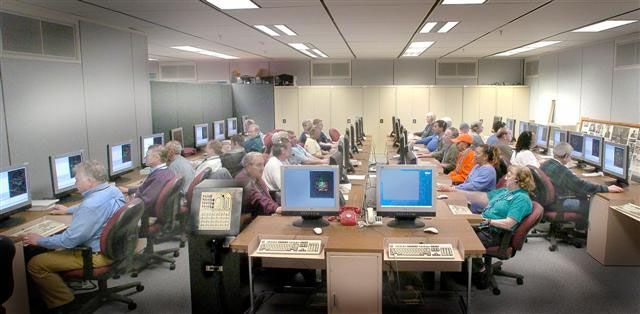
Standards (ATP PTS). These standards were met
                                                              78% of the time on simulated approaches to
                                                              Daytona Beach airport in Daytona Beach, FL, as
                                                              opposed to 55% of the time using baseline
                                                              conventional displays. This is a significant
                                                              improvement over the pilots’ performance with
                                                              today’s conventional instruments.
                                                                    Development has been conducted on a dual
                                                              mode enhanced vision sensor comprised of a low
                                                              light level Charge-Coupled Device and an uncooled
                                                              long wave Forward Looking Infrared (FLIR)
                                                              imager [25]. This Enhanced Vision System (EVS)
                                                              can allow pilots to see at night and enhance visual
                                                              penetration through low visibility conditions such
                                                              as rain, haze, and snow. Work has also been
Figure 8. Flight Experiment Cross Track Error                 conducted on fusing EVS images with a SVS
Of SVS/HiTS/FD Guidance Display Compared                      database, allowing pilots to detect obstacles that are
   With Conventional Instrumentation On                       not in the terrain database. An added feature of
       Approach To Wakefield Airport                          fusing EVS with SVS is that any database
      SouthEast SATS Lab conducted a simulated                inaccuracies due to either GPS/WAAS or database
flight experiment using advanced display concepts             errors can be detected [26]. Research was
on their SmartDeck system [24]. The SmartDeck                 conducted into the percentage of EVS or SVS that
system provided the pilot with a visual display of            dominated the display. Simulation testing showed
the primary flight instrumentation such as airspeed,          that pilots preferred synthetic vision database fused
altitude, and heading, along with a visual depiction          with lower percentage of enhanced vision
of the pilot’s flightpath in a HiTS display format            information at the start of the approach, with a
(Figure 9).                                                   gradual increase of enhanced vision information as
                                                              the aircraft neared the runway.
                                                                    Research and development has also been
                                                              conducted on a Head-Up Display (HUD). This type
                                                              of display has primarily been used for military and
                                                              commercial applications in the past, but has not
                                                              been affordable for the general aviation community.
                                                              A low cost HUD has been designed to display
                                                              critical flight performance information along with
                                                              flight guidance cues to the pilot in a “head up”
                                                              manner [27, 28]. This is particularly important
                                                              while on approach, thus allowing the pilot to
                                                              maintain the out-the-window monitoring for
                                                              optimum safety of flight (Figure 10). The HUD is
                                                              being developed and tailored for general aviation
                                                              aircraft through the Maryland Mid-Atlantic SATS
  Figure 9. SmartDeck Advanced Display with                   lab to project real-time EVS imagery of the external
            SVS/HiTS/FD Guidance                              scenery. A new FAA ruling (RIN 2120-AH78) has
                                                              approved the operational use of an FAA-certified
     Results from the experiment showed that the
                                                              Enhanced Flight Vision System with a Head-Up
HiTS provided guidance and situation awareness in
                                                              Display to allow a pilot to continue the approach
such a fashion that low-time single pilots under
                                                              from Decision Height (DH) or Minimum Descent
simulated instrument conditions were able to fly at
                                                              Altitude (MDA) to 100 ft. above the touch down
the FAA Airline Transport Pilot Practical Test

                                                       13.A.1-7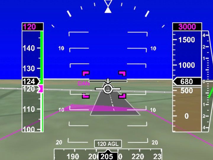
zone elevation [29]. The required visual references            service providers can reduce the cost of the ticket to
of the runway environment or approach light                    the traveler by as much as 15% for terrain
system must be presented on the HUD during the                 challenged regions [30].
straight in landing instrument approach. This
criteria is well within the desired goals of the Lower
                                                               Increased Single-Pilot Performance
Loading Minima operating capability of IFR
approaches down to 200 ft. minimum.                                 The fourth key operating capability of SATS is
                                                               to increase single pilot safety, precision, and
                                                               mission completion through the use of human-
                                                               centered automation. An example of this
                                                               automation is intuitive and easy to follow flight
                                                               path guidance superimposed on a depiction of the
                                                               outside world, coupled with onboard flight
                                                               planning/management systems [1, 2]. This
                                                               capability focuses on developing technologies that
                                                               will reduce pilot workload, enhance situation
                                                               awareness, and offer more intuitive navigation and
                                                               aircraft control for improved performance and
                                                               safety.
                                                                    Some of the enabling technologies to increase
                                                               single pilot performance are:
 Figure 10. Final Approach to Tipton Airport                       •   Advanced Displays;
 Runway with Low Cost Head-Up Display and
                                                                   •   Integrity Monitoring and Decision-
    EVS Imagery for Increased Safety and
                                                                       aiding automation;
                Performance
                                                                   •   Head-up automation.
      Developing technologies that will improve the
pilot's ability to consistently and accurately                      A number of the key technologies previously
navigate to a reduced Decision Height without the              discussed in the Lower Landing Minima operating
need for costly ground based instrument systems,               capability fall under this operating capability too
will greatly improve the ability to achieve near all-          (SVS, EVS, HiTS, and HUD) due to enhancing
weather accessibility to small community airports.             pilots situation awareness and safety.
SATS transportation system studies have shown
                                                                     Advanced displays, such as Multi-Function
that the technologies developed for Lower Landing
                                                               Displays (MFD), provide navigational tools to the
Minima, along with the RNP approach designs can
                                                               pilot throughout all phases of the flight. One of the
make access to airports more feasible with
                                                               technologies developed to increase single pilot
restrictions caused by weather, noise abatement,
                                                               performance has been the Virginia SATS Lab low-
terrain, obstacles, and special use airspace. This
                                                               cost Electronic Flight Bag (EFB). The EFB is a
will have a significant impact on reducing the
                                                               portable electronic device, that provides navigation
number of delays and cancellations, making SATS
                                                               information, flight planning capabilities, monitors
a significantly more viable transportation
                                                               weather, and provides HVO functionality to the
alternative.
                                                               general aviation pilot (Figure 11). Flight planning
     In fact, system studies have shown that when              can be conducted from home on the EFB, and then
reliable SATS air-taxi service can be provided at              easily transferred to the aircraft for flight
the more than 3400 small airports, there is a 25%              navigational operations [31, 32]. The EFB’s most
increase in the total demand for affordable air-taxi           predominant function will be to display flight
service [12]. In addition, increasing the reliability          status, performance, and safety data to the pilot.
of accessing small airports with the use of the LLM            The pilot can select which information to display
technologies reduces the cost of providing the                 during each phase of the flight. A “connected” EFB
service. By reducing cancellations and delays the              compliments the latest glass flight deck systems in

                                                        13.A.1-8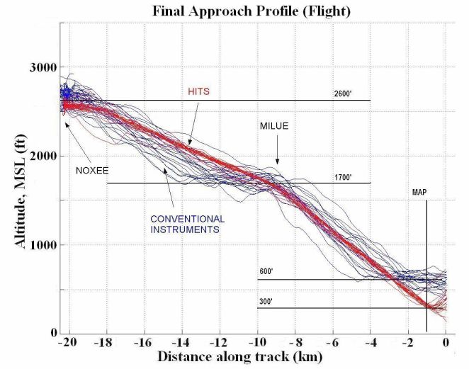
new aircraft. In the next few decades EFBs may be               [36]. This cost reduction could be realized when
the only glass displays on the thousands of legacy              utilizing SATS capability through an air-taxi
aircraft flying around the world. Possibly in the               service. The savings are realized by reducing the
future, an EFB, an ADS-B system and a datalink                  costs associated with paying for certified
radio are all a pilot would require to safely enable            professional pilots. This cost reduction can make
the HVO and LLM operating capabilities [33].                    the SATS vision more feasible and marketable.

 Figure 11. The Electronic Flight Bag Provides
    the Pilot HVO Functionality and Flight
    Information at the Danville SATS SCA                        Figure 12. The ‘Cockpit Associate’ Aids the Pilot
                                                                in Flying Safely and Proficiently by Conducting
     In-flight decision aiding tools, such as the                    Situation Assessments, and Providing
Maryland Mid-Atlantic SATS Lab’s ‘Cockpit                              Recommendations and Advisories
Associate’, are being developed through the SATS
project. The ‘Cockpit Associate’ can increase
pilot’s situation awareness by reporting audio-                 Demonstration of Technologies
visual alerts on traffic, weather conditions, aircraft                Throughout the five-year effort of the SATS
health, and approach procedures through the                     project, both research and development have been
aircraft's audio system and Multi-Function Display              conducted on key concepts, procedures, and
[34, 35]. The ‘Cockpit Associate’ can continuously              technologies to strive for the convenience of on-
aid the pilot by conducting situation assessment,               demand, point-to-point air travel using small under-
conflict detection and alerting, and reporting                  utilized airports. The SATS project culminated
important notifications, recommendations, and                   with the 2005 SATS Public Demonstration in
advisories (Figure 12). This decision-aiding tool is            Danville, VA. on June 5th-7th, by showcasing the
being integrated into a Head-Up Display to                      accomplishments achieved throughout the project
conveniently notify the pilot on approach of any                and proving that a small aircraft transportation
pertinent information. These decision-aiding                    system is viable. The main tent pavilion was
devices can lead to improved operational efficiency             constructed on the south ramp of the Danville
in low-visibility conditions.                                   Regional Airport specifically for the demonstration
     The cockpits of the future may become quite                (Figure 13). This pavilion housed exhibits manned
simplified with only a few advanced systems and                 by SATS engineers and researchers that
displays such as these, to meet the flight objectives           demonstrated many of the technologies that were
of the pilots from takeoff to landing. In addition,             integrated to enable the successful demonstration of
system studies have determined that single pilot                the four SATS operating capabilities in safe,
operations can reduce the cost of SATS operations               effective, and affordable systems for small aircraft.
by 16% compared to dual-pilot operations today

                                                         13.A.1-9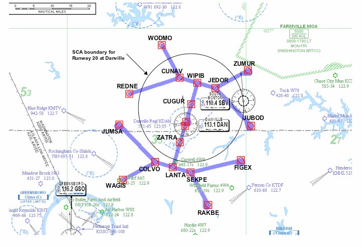
the intuitiveness and ease of use of the advanced
                                                             displays, as well as the HVO concept and
                                                             procedures developed through the project.
                                                                  A live proof-of-concept technology flight
                                                             demonstration of the four operating capabilities was
                                                             conducted on June 6th and 7th to show their
                                                             technical and operational feasibility. The flight
                                                             demonstration focused on how the airspace and the
                                                             many small and underutilized airports in the United
                                                             States could be utilized if SATS was implemented.
                                                             During the live technical demonstration, visitors
                                                             were able to view a digital depiction of a bird’s eye
                                                             view of the airport and surrounding airspace,
                                                             tracking all SATS participating aircraft along with
    Figure 13. South Ramp Area of Danville                   any pertinent AMM information (Figure 14);
   Regional Airport, where SATS 2005 Public                  cockpit displays; out-the-window or in-cockpit
           Demonstration Was Held                            view; and real-time demonstration of flight
     The stakeholders at the event were [37]:                guidance displays from the technology
                                                             demonstration flight. The displays and videos were
    •   Federal Agency Leaders – Key leaders                 presented on two large screens, and the bird’s eye
        in Federal Agencies involved in shaping              view was displayed during the entire show.
        the future of general aviation                       Narrators explained what the aircraft were about to
        transportation, such as FAA, DoT, and                do and directed the audience members to specific
        NASA.                                                features on the screens during the flight
    •   Local and State transportation/aviation              demonstration (Figure 15).
        authorities
    •   Members of committees and
        organizations relevant to air
        transportation, e.g., RTCA, GAMA, etc.
    •   Industry representatives from:
        o Avionics manufacturers
        o General aviation and business
            aircraft manufacturers
        o Air taxi/fractional ownership
            businesses
        o Small airport operators
    •   General public.

      The audience had an opportunity to gain an
understanding of the SATS technologies through
static displays, simulators, presentations, and a live
                                                                 Figure 14. Bird’s Eye View of the SATS Multi-
proof-of-concept technology flight demonstration.
                                                                  Aircraft Flight Scenario Demonstrated at the
Static displays describing the concepts,
                                                                   2005 Public Demonstration in Danville, VA
technologies, and procedures were organized by
operating capability and functionality. These static
displays included posters, videos, hardware, and
laptop simulators, and were staffed with
knowledgeable technical experts who explained the
technologies to interested visitors. Flight
simulators were also available to the public to show

                                                     13.A.1-10
trailer in order to conduct the AMM operations.
The AMM entry request information was provided
with the bird’s eye depiction of the aircraft within
the SCA, during the live presentation (Figure 14).
During the flight scenario, both video and data
were telemetered down from the aircraft to the
ground station and transferred to the tent venue for
the live presentation. The telemetered video and
data showcased the labs’ and NASA’s various
technical contributions to the project and
significance to the operating capabilities.
The Danville Regional Airport falls into the
classification of a SATS-type airport, in that it is a
Figure 15. Technical Flight Demonstration
non-towered/non-radar airport. The active runway
Presentation Showcasing the Four Operating
used for the flight demonstration was Runway 20.
Capabilities
Runways 13-31 were closed for the duration of the
The technology flight demonstration was a six- three-day event. During the flight demonstration,
aircraft integrated flight scenario conducted by the the airport was closed to any arriving traffic, except
members of the SATS project. The six SATS the six aircraft participating in the flight
aircraft included the NASA Cirrus SR22, the demonstration.
Maryland Mid-Atlantic SATSLab Cessna 402, the
The flight demonstration was conducted in
North Carolina & Upper Great Plains SATSLab
VMC, although the aircraft flew as though they
Piper Aztec, the SouthEast SATSLab Cessna 310,
were operating in IMC. A certified ILS approach to
the Virginia SATSLab King Air C90, and the FAA
Runway 02, and a GPS approach to Runway 20
Technical Center Convair. In order to conduct the
currently exist. However, a simulated SCA defined
HVO procedures, each SATS aircraft was equipped
for the Danville airport was constructed that
with:
consisted of two initial approach paths merging into
• GPS receiver; a T. A SATS GPS-T approach was overlaid on the
• GDL-90 Universal Access Transceiver, ILS approach to Runway 02, and also one was
UAT, 978 MHz radio [for Air-to-Air overlaid over the certified GPS approach for
and Air-to-Ground communications]; runway 20. For the SATS flight demonstration, the
• Either a VHF Datalink radio or VHF SATS GPS-T approach for runway 20 was used
Long Range Access Point radio [for Air- (Figure 5).
to-Ground communications]; The flight scenario was constructed to
• CDTI; demonstrate the four operating capabilities in an
• Software to conduct HVO procedures; integrated manner. Once cleared by the Safety
• Voice communication radios. Officer, the SATS flight director coordinated and
managed the SATS flight scenario by having all six
The NASA Digital Applications and Research aircraft take-off one at a time and fly to their pre-
Test System (DARTS) trailer, located at the defined transition fix locations (REDNE, WODMO,
Danville Airport facility, housed the ground station ZUMUR, and JUBOD) outside the Danville SCA in
(AMM), which received requests and provided the preparation for the HVO approach to Runway 20
sequencing information to the aircraft via the (Figure 16).
datalink [37, 38]. A Ground Based Transceiver
(GBT) received the ADS-B reception of aircraft to
aircraft “squitter”. The GBT was used to receive
aircraft position only. The aircraft position was
sent via Local Area Network (LAN) to the Ground
Based Server computer located in the DARTS
13.A.1-11one has landed and canceled its clearance. At this
point, the controller would then release the next
aircraft to execute the IFR approach. During this
SATS HVO scenario, up to four aircraft can be on
the approach simultaneously, significantly
increasing the number of operations possible at the
non-towered/non-radar airport.
As the Cirrus approached the IAF, live
telemetry of the Cirrus ‘within-the-cockpit’ view
was shown to the audience for the live presentation.
The Cirrus MFD was discussed, showing the
audience how the pilots had a clear picture of where
they were, and the flight environment around them,
including the location of the other aircraft in the
area.
Figure 16. SATS Fix Locations for the Danville
Regional Airport, with SCA Boundary for The following aircraft to enter the SCA
Approach to Runway 20 highlighted the technologies developed for Lower
Landing Minima and Single Pilot Performance in
All six participating aircraft could see each
order to guide the aircraft down safely in low
other on their CDTI, with traffic information
visibility. The third aircraft that requested entry
provided by the GDL-90 UAT air-to-air
(near the ZUMUR transition fix), and was granted a
communications. During the live demonstration,
vertical entry into the SCA, was the North Carolina
although it was VMC, it was portrayed to the
& Upper Great Plains SATS Lab aircraft. During
audience that the scenario being flow was
the live demonstration, the aircraft PFD and MFD
developed for IMC in low visibility and that the
data was telemetered to the ground and recreated on
aircraft were handed off from the air traffic
the screen to show the audience the SVS/HiTS/FD
controller into the SCA. Once the flight director
guidance cues, highlighting the intuitive of the
commenced the start of the live demonstration, the
displays. The pilot consistently and accurately flew
first aircraft, the FAA Convair, approached the
the HiTS approach that was programmed for the
SCA (near the JUBOD transition fix) and requested
Danville airport runway. With the pilot keeping the
entry using the air-to-ground datalink. The request
flight predictor symbol centered in the guidance
was received by the AMM at the ground station and
box, the aircraft could accurately follow the
a message with the sequence information was sent
pathway. The MFD gave the pilot a clear view of
back to the Convair, via ground-to-air datalink,
his current position on the approach path as well as
granting a lateral entry into the SCA and displayed
his desired path.
on the aircraft display. The aircraft was directed to
go to the JEDOR IAF, with JEDOR as the MAHF. The fourth aircraft to request and be granted a
vertical entry into the SCA (near the REDNE
The second aircraft to request entry into the
transition fix) was the SouthEast SATS Lab aircraft.
SCA was the NASA Cirrus (near the REDNE
This aircraft showcased their advanced display, the
transition fix). The Cirrus was granted a lateral
“SmartDeck”, that displays key flight critical data
entry into the SCA, and directed (1) to follow the
overlaid on SVS with HiTS and FD guidance. This
FAA aircraft on approach, and (2) go to the
display had other important features such as
CUNAV IAF. CUNAV was assigned as the Missed
autopilot, WAAS integrity monitor, and caution and
Approach Holding Fix also. Note, the pilots are
warning display for critical aircraft systems such as
responsible for following their sequence and
engine monitoring. A number of different
maintaining self-separation from other aircraft.
information pages exist. Some of these include
Under current standard procedures, since the
various views of the airport approach or automated
controller does not have the radar coverage of the
checklists.
Danville airport area, the controller would hold all
but one aircraft away from the approach until that
13.A.1-12The fifth aircraft to request and be granted viability of the HVO concept, by significantly
entry into the SCA (near the ZUMUR transition fix) increasing the operational rate at the non-towered/
was the Virginia SATS Lab aircraft. For this non-radar airport using self-separation and flight-
aircraft, the aircraft state data was telemetered down path guidance technologies. The total time from the
to the ground to recreate the EFB display that the first aircraft AMM entry request, from outside the
pilot was using in flight. It was explained that the SCA, until all six aircraft had landed was ~31
pilot could select needed information to be minutes in the demonstration. In addition, the
displayed during each phase of the flight. During advanced display technologies demonstrated for the
the flight scenario, the EFB displayed a moving Lower Landing Minima capability, showed intuitive
map showing all aircraft within the SCA including flightpath guidance that could provide the pilot
terrain, weather, and other safety information. In increased accuracy and situation awareness
addition, the AMM sequencing information was compared to conventional instrumentation in poor
displayed. weather conditions. It was demonstrated how
Single Pilot Performance could be realized through
The last SATS aircraft to request and be
use of onboard decision-aiding automation tools to
granted entry into the SCA (near the WODMO
assist the pilot throughout all phases of the flight.
transition fix) was the Maryland Mid-Atlantic
SATS Lab aircraft. Both the aircraft state data and Transportation engineers at Virginia Tech
the HUD with EVS video was telemetered down to predicted up to 15 million SATS passenger-
the ground. The real-time state data from the trip/year, if an air-taxi service could be provided at
aircraft was used to recreate a flight simulation a cost of $1.75 per passenger-mile in 2010. When
display with the HiTS. The HiTS display illustrated SATS technology matures, costs of $1.25 per
the ease with which the pilot could maintain his passenger mile might be possible increasing the
final approach with the intuitive display onboard market share to 29 million person trips per year.
the aircraft. The telemetered video of the HUD Today, business passengers traveling in commercial
display with EVS included the final approach to the airlines pay $0.90 per passenger-mile in a typical
Danville airport. The HiTS and the flight 350 mile trip. However, SATS travelers would
information were overlaid onto the infrared imagery save an average of 3 hours per trip based on a
from an EVS. The HUD allows the pilot to keep an nationwide analysis [39].
out-the-window view, so the pilot can quickly spot
the runway as the aircraft breaks out of the clouds
for landing during IMC. Conclusions
SATS is a vision for a new kind of air travel.
The ‘Cockpit Associate’ was also discussed,
This vision is that air transportation can meet the
illustrating how its functionality was used as
needs of more people by assuring the safety, speed,
intelligent automation to provide timely information
and convenience of point-to-point air travel through
to aid the pilot. The system reminded the pilot of
a network of more than 3400 under-utilized airports
relevant checklists, and kept track of which items
in near all-weather conditions. The SATS project
had been completed. The pilot can interact by voice
has been a research and development venture to
or manually. It uses an advanced knowledge based
foster the development of advanced concepts,
processor to infer the needs of the pilot based on the
technologies, and procedures that will provide a
flight plan, traffic conditions, airspace, boundaries,
technical and economic basis to develop a small
airport status, and weather. This tool can make
aircraft transportation system that could
flying as a single pilot considerably easier.
compliment today’s airline system.
The outcome of the 2005 demonstration was
The project has focused on four key operating
intended to inspire public understanding, and
capabilities to take the first steps in making the
confidence, in the ability of new aviation
SATS vision a reality. The four operating
technologies to enable the use of smaller aircraft
capabilities: Higher Volume Operations at Non-
and smaller airports for public transportation [4].
Towered/Non-Radar Airports, En Route Procedures
The flight scenario flown during the live
and Systems for Integrated Fleet Operations, Lower
demonstration confirmed to the audience the
Landing Minimums at Minimally Equipped
13.A.1-13Landing, and Increased Single Pilot Performance Operations Concept: Normal Operations.
have been researched, developed, evaluated, and NASA/TM-2004-213022.
implemented in an integral fashion for
[5] Murdoch, Jennifer L., et. al., May 2005, Small
demonstration at the 2005 SATS Public
Flight Experiment Investigation of General
Demonstration in Danville, VA. The technology
Aviation Self-Separation and Sequencing Tasks.
demonstration showcased that a small aircraft
NASA/TP-2005-213539.
transportation system could be both feasible and
viable, and could revolutionize how we travel in the [6] Williams, Daniel, et. al., August 2004,
future. The four operating capabilities described Preliminary Validation of the Small Transportation
could pave the way for a time when one can System Higher Volume Operations (SATS HVO)
affordably go anywhere – any time – by taking Concept. ICAS 2004 24th International Congress of
advantage of thousands of small community the Aeronautical Sciences.
airports located all across the nation. [7] Magyarits, Sherri M., Nicole S. Racine, Jerry A.
The HVO concept and procedures have shown Hadley, May 2005, Air Traffic Control Feasibility
that the volume of aircraft into and out of small Assessment of Small Aircraft Transportation
airports could increase by four times compared to System (SATS) High Volume Operations (HVO).
today’s procedural separation by air traffic Final Report. DOT/FAA/CT-05/26.
controllers. The FAA and NASA have worked [8] Hadley, Jerry, Nicole Racine, July 2005
closely together to assess the viability and Transportation Systems Analysis and Assessment,
feasibility of integrating the HVO concepts and Small Aircraft Transportation System (SATS)
procedures into the NAS identifying the steps that Demonstration. Technical Report. DOT/FAA/CT.
need to be taken next. Technologies researched and In review process.
developed within the Lower Landing Minimums
and Single Pilot Performance operating capabilities [9] William J. Hughes FAA Technical Center, June
demonstrated increasing navigational accuracy, 2005, SATS Simulations, Tear Sheet. SATS 2005
reducing pilot workload, improving situation Public Demonstration.
awareness, and improved safety, thus taking a big [10] Hinze, Nicolas, A. A. Trani, June 2004, SATS
step towards the SATS vision of taking advantage Airport Set White Paper, VA. Tech. Air
of the small community airports in near all weather Transportation System Lab.
conditions. Further research and analysis need to be
conducted on the procedures and technologies, with [11] Holmes, Bruce J, Michael H. Durham,
intentions of proceeding further to implementation January-February 2004, “Small Aircraft
into the NAS and commercialization of products for Transportation System Concept and Technologies”.
the aviation community. Journal of Aircraft, Vol. 41.
[12] Trani, Toni, November 2004, LLM/SPP
References Meeting, National Transportation Systems Analysis
for the SATS Program, NCAM.
[1] Hefner, Jerry, Airspace Systems Program: Small
Aircraft Transportation System (SATS) FY05 [13] Hickok, Stephen M., Edwin D. McConkey,
Project Plan V 2.0. Maryland Mid-Atlantic SATS Lab Report; WAAS
Approach Procedures for NASA SATS
[2] NASA Langley Research Center; Small Aircraft Demonstration at Danville, VA. January 6, 2005.
Transportation System Program: 2010 Concepts of
Operations Document. July 2002. [14] Wilson, Ian, Embry-Riddle Aeronautical
University, SESLC Report, April 29, 2004, SATS
[3] Team Vision, Southeast SATS Lab Report, Airport Experimental RNAV/RNP Procedures.
February 2002, SATS Return Investment Study
Report. [15] Alter, K. W., Paul Snow, and Randall Davis,
March 2004, Flying Complex Curved RNP
[4] Abbott, Terence S., et al., August 2004, Small Approaches into North Carolina Airports,
Aircraft Transportation System, Higher Volume
13.A.1-14NASA/NCAM report SL3112D1, D2 & D3, Fusing Synthetic Vision Database and Navigation
Hampton, VA. Information with Advanced Sensor Images to
Enhance LLM Approaches.
[16] Davis, Randall C., Dennis W. Wilt, James T.,
K. W. Alter, and Paul Snow, February 2004, Flight [27] Kollsman Inc., Maryland Mid-Atlantic SATS
Tests for LLM Approaches Using Advanced Lab Report, December 16, 2004, System
Cockpit Display Technology, NASA/NCAM report Component Level Specification for Low Cost
SL3112D4 & D5, Hampton, VA. Head-Up Display.
[17] Davis, Randall C., Dennis W. Wilt, James T. [28] Kollsman Inc., Maryland Mid-Atlantic SATS
Henion, K. W. Alter, Paul Snow, John Deaton, Lab Report, December 10, 2004, Low Cost Head-
April 2005, Formal Tests For LLM Approaches Up Display Critical Design Review Results.
Using Refined Cockpit Display Technology.
[29] Federal Register Part II Department of
Proceedings of SPIE – The International Society for
Transportation. Federal Aviation Administration.
Optical Engineering, Paper #5802-23, Volume
February 9, 2004. 14 CFR Parts 1, 91, et al.
5424, Orlando, Florida.
Enhanced Flight Vision Systems; Final Rule.
[18] Maryland Mid-Atlantic SATS Laboratory
[30] RTI International, June 27 2005, MCATS
University Research Foundation, August 12, 2005,
Analyses for Danville and High Impact SATS
Flight Experiment Results MMSL04016T Final
Markets. NCAM #SL05064T.
Report.
[31] OPTechnologies, Virginia SATS Lab Report,
[19] Glaab, Louis J., Monica F. Hughes, October
August 26, 2004. SPP Advanced EFB R&T
2003, Terrain Portrayal For Head-Down Displays
Systems Development Proactive User-Interfaces for
Flight Test. 22nd Digital Avionics Systems
SATS LLM.
Conference.
[32] Strategic Aeronautics, Virginia SATS Lab
[20] Hughes, Monica F., Louis J. Glaab, October
Report, September 30, 2004, Electronic Flight Bag
2003, Terrain Portrayal For Head-Down Displays
Software Version 2 (White Paper).
Simulation Results. 22nd Digital Avionics Systems
Conference. [33] Johnson, Sally, Roz Cooperman, June 4, 2005.
Main Stage Flight Demonstration Script, Show
[21] Glaab, Louis J., April 2004, Synthetic Vision
Copy, SATS 2005 Public Demonstration.
Systems General Aviation Equivalent Safety
Experiment (SVS-ES), NASA LaRC. [34] University Research Foundation Applied
Systems Intelligence, Inc., Maryland Mid-Atlantic
[22] Old Dominion University, Virginia SATS Lab
SATS Lab Report, December 7, 2004. Cockpit
Report; June 30, 2004, “Energy Management
Associate Knowledge Base Functionality Update
Guidance Specifications”.
Report.
[23] Old Dominion University, Virginia SATS Lab
[35] Maryland Mid-Atlantic SATS Laboratory
Report, September 30, 2004, Simulations for RNP
University Research Foundation, March 31, 2005,
Instrument Approach & Departure and Simulations
Human-In-The-Loop Cockpit Associate Simulation
for Refined Flight Guidance Procedures.
Experimental Results MMSL04010T Final Report.
[24] Doherty, Shawn M. May 2005, Single Pilot
[36] RTI International, March 2004, NC&UGP
Performance Study Preliminary Outcome.
SATS Lab, ‘Trade Study Impact of SATS
SouthEast SATS Lab Consortium, Embry-Riddle
Technologies’, NCAM #SL333D.
Aeronautical University.
[37] Johnson, Sally, January 2005, Small Aircraft
[25] Ferrante, Ron, and Tim Rand, Visible/Long
Transportation System Program, 2005
Wave Infrared Dichroic Beamsplitter, Journal of
Demonstration Plan, Revision 1.5.
Optical Engineering, in press.
[38] Grube, Richard, August 11, 2004,
[26] Archer, Cynthia, Paul Snow, James Henion,
Preliminary/Critical Review for the Digital
NC&UGP SATS Lab Report, February 27, 2004,
13.A.1-15Applications and Research Test System. NASA Email Addresses
LaRC.
Sally A. Viken, Sally.A.Viken@larc.nasa.gov
[39] Trani, A. A., Hojong Baik,, June 2005, SATS
Frederick M. Brooks, F.M.Brooks@larc.nasa.gov
Operations Have Positive National Impact, Volume
1, Number 3. VA. Tech. Air Transportation
Systems Lab. Danville 2005 Demonstration.
24th Digital Avionics Systems Conference
October 30, 2005
13.A.1-16You can also read