Controlled flight into terrain involving Cessna 182, VH-DJN - ATSB Transport Safety Report
←
→
Page content transcription
If your browser does not render page correctly, please read the page content below
Controlled flight into terrain
involving Cessna 182, VH-DJN
14 km south-south-west of Atherton Airport, Queensland, on 8 April 2019

 ATSB Transport Safety Report
 Aviation Occurrence Investigation
 AO-2019-018
 Final – 17 September 2020
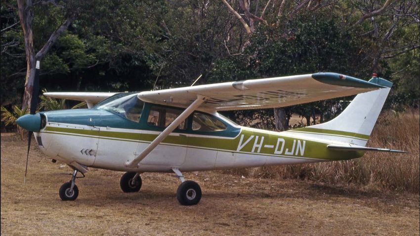
Cover photo:       VH-DJN in 1982 – Gavin Hughes: AirHistory.net

Released in accordance with section 25 of the Transport Safety Investigation Act 2003

Publishing information
Published by:            Australian Transport Safety Bureau
Postal address:          PO Box 967, Civic Square ACT 2608
Office:                  62 Northbourne Avenue Canberra, ACT 2601
Telephone:               1800 020 616, from overseas +61 2 6257 2463
                         Accident and incident notification: 1800 011 034 (24 hours)
Email:                   atsbinfo@atsb.gov.au
Website:                 www.atsb.gov.au

© Commonwealth of Australia 2020

Ownership of intellectual property rights in this publication
Unless otherwise noted, copyright (and any other intellectual property rights, if any) in this publication is owned by the
Commonwealth of Australia.

Creative Commons licence
With the exception of the Coat of Arms, ATSB logo, and photos and graphics in which a third party holds copyright,
this publication is licensed under a Creative Commons Attribution 3.0 Australia licence.

Creative Commons Attribution 3.0 Australia Licence is a standard form licence agreement that allows you to copy,
distribute, transmit and adapt this publication provided that you attribute the work.
The ATSB’s preference is that you attribute this publication (and any material sourced from it) using the following
wording: Source: Australian Transport Safety Bureau

Copyright in material obtained from other agencies, private individuals or organisations, belongs to those agencies,
individuals or organisations. Where you want to use their material you will need to contact them directly.

Addendum

    Page                Change                                                                          Date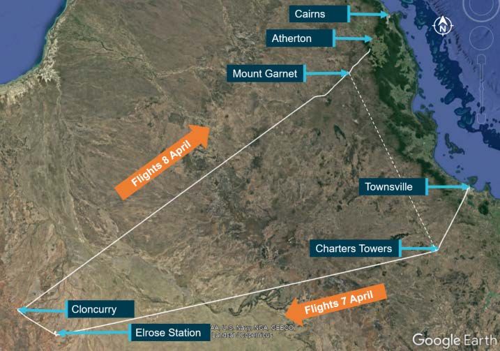
Safety summary
What happened
On 8 April 2019, at 0650 Eastern Standard Time, a Cessna Aircraft Company 182 aircraft,
registered VH-DJN, departed Cloncurry Airport on a private flight to Mount Garnet aerodrome,
Queensland (Qld), under visual flight rules (VFR). On board were the pilot and one passenger.
The aircraft landed in Mount Garnet at 0920, where the passenger disembarked and left the
aerodrome. The passenger planned to return to the aerodrome at about 1500 for an onward flight
(in VH-DJN) to Charters Towers, Qld.
At 0934, the aircraft departed Mount Garnet for a 62 km VFR flight to Atherton Airport, where the
pilot intended to refuel the aeroplane before returning to collect the passenger from Mount Garnet.
However, 15 minutes after departing Mount Garnet and about 14 km from Atherton, the aircraft
impacted trees and terrain on the Herberton Range. The impact fatally injured the pilot and the
aircraft was destroyed.

What the ATSB found
The ATSB found that the pilot, who was qualified only to operate in visual meteorological
conditions, flew toward and entered an area of low cloud and reduced visibility, which obscured
rising terrain. This almost certainly resulted in the pilot losing visual reference with the ground and
a controlled flight into terrain.
While it could not be determined whether it influenced the accident, the pilot had taken medication
that had the potential to affect performance and was therefore required to be disclosed to the Civil
Aviation Safety Authority (CASA). This medication had not been disclosed to the pilot's
Designated Aviation Medical Examiner or recorded on the pilot's CASA medical file.

Safety message
The ATSB is concerned about the frequency of accidents, many fatal, which involve pilots flying
with reduced visual cues. The risks associated with operating under the visual flight rules in
adverse weather appear to be under-estimated. The ability to understand weather-related hazards
and how to assess and mitigate them, are vital skills for pilots, particularly those who fly in
challenging environments like mountainous terrain.
Weather conditions must be considered during pre-flight planning, assessed and reassessed
during flight and pilots should have a rehearsed plan in case weather deteriorates.
• VFR pilots should use a ‘personal minimums’ checklist to help control and manage flight risks
  through identifying risk factors that include marginal weather conditions and only fly in
  environments that do not exceed their capabilities.
• During flight, pilots must continuously assess the weather for conditions that may adversely
  affect the safety of the flight and be prepared to use an alternative course of action if conditions
  deteriorate. They should make timely decisions to turn back, divert or hold in an area of good
  weather.
• Pressing on into instrument meteorological conditions without a current instrument rating and a
  suitably-equipped aircraft, carries a significant risk of disorientation and a loss of spatial
  awareness from reduced visual cues. This can easily affect any pilot, no matter what their level
  of experience.

                                                  ›i‹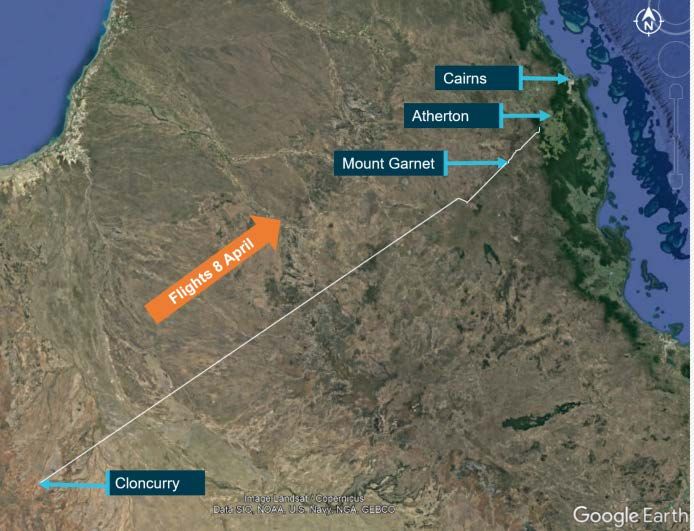
Contents
  Safety summary ........................................................................................................................i
  The occurrence ........................................................................................................................1
    Accident day                                                                                                                         1
    Previous day                                                                                                                         3
  Context ......................................................................................................................................4
    Pilot information                                                                                                                           4
              Qualifications and experience                                                                                                    4
              Medical and pathological information                                                                                             4
       Aircraft information                                                                                                                    5
       Accident site and aircraft wreckage information                                                                                         5
       Meteorological information                                                                                                              6
              Graphical area forecast                                                                                                          6
              Grid-point wind and temperature forecast                                                                                         7
              Aerodrome forecasts                                                                                                              7
              Bureau of Meteorology observations                                                                                               7
              Satellite imagery                                                                                                                8
              Witness observations                                                                                                             9
              Carburettor icing                                                                                                                9
       Pre-flight planning                                                                                                                     9
              Visual flight rules                                                                                                             9
              Weather planning                                                                                                                9
              Fuel planning                                                                                                                  10
       Visual flight into instrument meteorological conditions                                                                               10
              Adverse weather conditions and reduced visual cues                                                                             10
              Controlled flight into terrain                                                                                                 10
              Spatial disorientation and loss of control                                                                                     11
              Factors contributing to VFR into IMC                                                                                           11
       Related occurrences                                                                                                                   11
  Safety analysis ...................................................................................................................... 13
     Loss of visual reference and controlled flight into terrain                                                                         13
     Undisclosed medication                                                                                                              13
  Findings ................................................................................................................................. 14
     Contributing factors                                                                                                                    14
     Other factors that increased risk                                                                                                       14
     Other findings                                                                                                                          14
  General details ...................................................................................................................... 15
  Sources and submissions .................................................................................................. 16
  Australian Transport Safety Bureau .................................................................................. 18

                                                                  › ii ‹
ATSB – AO-2019-018

The occurrence
Accident day
On 8 April 2019, at 0652 Eastern Standard Time, 1 a Cessna 182G aircraft, registered VH-DJN,
departed Cloncurry aerodrome on a private flight to Mount Garnet, Queensland, under the visual
flight rules (Figure 1). 2 On board were the pilot and one passenger, who was the aircraft owner.
Figure 1: Map of Queensland locations relevant to the occurrence showing the
approximate track of VH-DJN on the accident day

Source: Google Earth and aircraft GPS, annotated by ATSB

The aircraft landed at Mount Garnet aerodrome at 0920, where the passenger disembarked. The
passenger left the aerodrome, intending to return at about 1500 for an onward flight to Charters
Towers. In the interim, the pilot planned to fly to Atherton Airport to refuel and then return to Mount
Garnet. Atherton Airport, elevation 2,460 ft above mean sea level (AMSL), was 63 km north-east
of Mount Garnet aerodrome, elevation 2,156 ft AMSL. Between these locations lay the Herberton
Range, where the highest peaks in the vicinity of the direct track reached about 4,000 ft AMSL.
The aircraft took off from Mount Garnet at 0934:31, with the pilot as the sole occupant. Based on
the aircraft’s GPS data, it initially tracked directly towards Atherton Airport for about 4 minutes,
before diverging east of the direct route (Figure 2).

1
    Eastern Standard Time (EST): Coordinated Universal Time (UTC) + 10 hours
2
    Visual flight rules: a set of regulations that permit a pilot to operate an aircraft only in weather conditions generally clear
    enough to allow the pilot to see where the aircraft is going.
                                                               ›1 ‹
ATSB – AO-2019-018
Figure 2: Recorded flightpath of VH-DJN (red) and direct track (yellow)
Source: Google Earth overlaid with aircraft’s recorded GPS track, annotated by ATSB
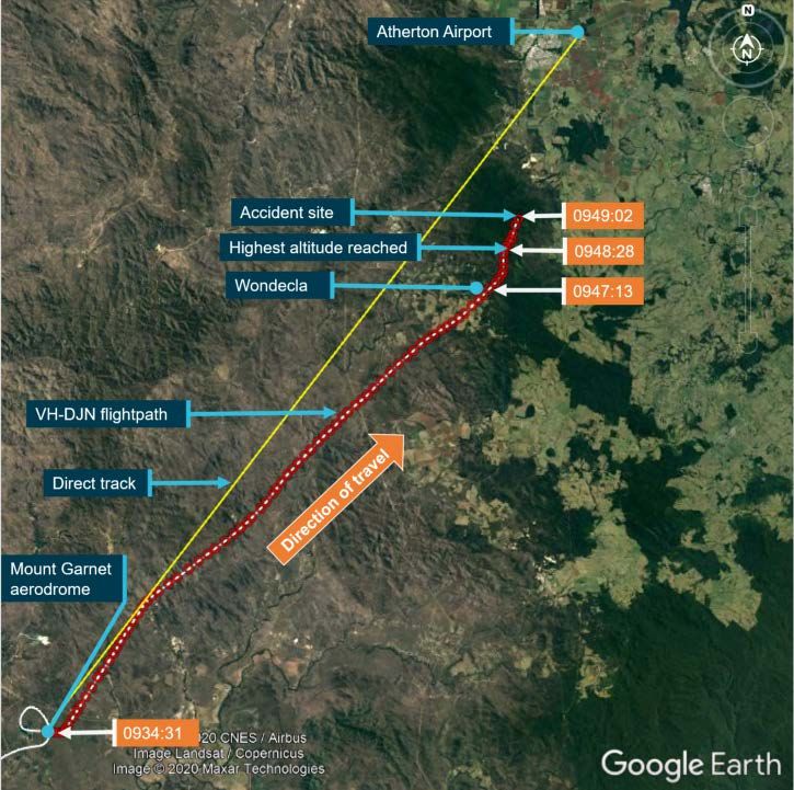
The aircraft made small deviations right and left as it tracked north-east and passed overhead
Wondecla at 0947:13 climbing through 4,144 ft. Over the next 30 seconds, the aircraft climbed to
about 4,400 ft, which was the maximum height reached, before starting to descend. As the aircraft
descended about 500 ft over the next 76 seconds, small changes in direction and two short climbs
were made (Figure 3).
The aircraft’s last recorded GPS position was at 0949:02 at an altitude of 3,916 ft and heading
north-north-east. The terrain elevation at that position was 3,774 ft 3 and the terrain and GPS
altitudes were each correct to within about 100 ft.
The aircraft impacted the tree canopy and subsequently terrain, fatally injuring the pilot. The
130 metre-long wreckage trail was consistent with significant forward speed at impact (about 240
km/h ground speed based on GPS data) and the aircraft was destroyed. No radio transmissions
by the pilot were recorded on any available frequency
3
Geoscience used a Digital Elevation Model, which represents ground surface topography, with vegetation features
removed using an automatic process supported by several vegetation maps.
›2 ‹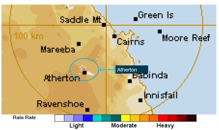
ATSB – AO-2019-018

Figure 3: Terrain elevation (green) and VH-DJN GPS altitude (blue) for the accident flight

Source: Geoscience Australia and aircraft GPS recorded data

Previous day
The flights conducted on the day prior to the accident flight, 7 April, are depicted in Figure 4. The
pilot operated VH-DJN alone from Townsville Airport, departing at 0557 and arriving at Charters
Towers aerodrome at 0624. The (same) passenger joined the pilot at Charters Towers and after
refuelling the aircraft, the pilot and passenger flew to Elrose Station, arriving at 0849. Later that
day, the aircraft departed Elrose Station for a 27-minute flight to Cloncurry, where the pilot and
passenger stayed overnight.
Figure 4: Map of Queensland locations relevant to the occurrence and previous day’s
flights including the aircraft track

Source: Google Earth and aircraft GPS, annotated by ATSB

                                                              ›3 ‹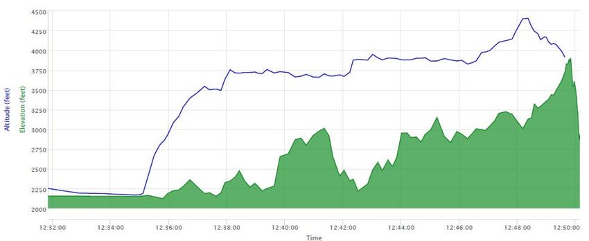
ATSB – AO-2019-018

Context
Pilot information
Qualifications and experience
The pilot held a private pilot (aeroplane) licence that was issued under Civil Aviation Safety
Regulations Part 61 in November 2014. The Civil Aviation Safety Authority (CASA) reported that
the pilot’s original licence was issued in 1975. The ATSB was unable to obtain the pilot’s logbook
after the accident. However, as at 8 July 2017, the pilot’s logbook had recorded 6,532 hours total
aeronautical experience, at which time the pilot had recorded 3,967 hours on the Cessna 182
aircraft type.
The pilot’s last review was a night visual flight rules (VFR) 4 and single-engine aeroplane class
rating fight review, conducted in April 2018 and valid until April 2020. Night VFR operations are
based on visual procedures in visual meteorological conditions (VMC). 5 Additionally, the CASA
advisory circular (AC) 61-05 Night VFR rating stated:
        4.3.2 Night operations require proficiency in instrument flight (IF)…
        4.3.3 Instrument flying skills are intrinsic to night flying; therefore, it is also desirable that IF proficiency
        be demonstrated before commencing actual night flying.
        4.3.4 While NVFR flight must be conducted in VMC, a visual horizon is often not available and a
        sudden loss of visual reference is also possible (i.e. when turning away from a well-lit area, reduced
        visibility or even following inadvertent entry into cloud). Night flying training should therefore
        emphasise the importance of flying the aircraft by reference to the flight instruments integrated with
        visual flying, even in conditions where external lighting provides adequate visual reference.

The pilot had previously held a multi-engine aeroplane instrument flight rules (IFR) 6 rating, with
the last renewal recorded in the logbook conducted in October 2010.

Medical and pathological information
The 73-year-old pilot held a Class 2 Medical Certificate, valid until September 2020. The certificate
required the pilot to wear distance vision correction and a headset while flying and have vision
correction available for reading.
The autopsy report identified that the pilot had coronary artery atheroma of a severity that could
have led to a cardiac event. This was consistent with the general practitioner’s assessment that
the pilot had a history of moderately high cardiovascular risk. However, it could not be determined
whether this had occurred or had any influence on the pilot’s actions.
Post-mortem toxicological examination of the pilot’s blood revealed the presence of a
benzodiazepine, a hypnotic sedative medication, consistent with a therapeutic dosage and a blood
alcohol concentration (BAC) of 0.03 per cent. The pilot’s BAC reading may have been due at least
in part to post-mortem alcohol production and no alcohol was detected in the urine. The pilot was
reported to have consumed two alcoholic drinks with dinner the previous evening. This was not in
accordance with patient guidelines for the sedative medication. Additionally, in some people,

4
    VFR: a set of regulations that permit a pilot to operate an aircraft only in weather conditions generally clear enough to
    allow the pilot to see where the aircraft is going.
5
    VMC: an aviation flight category in which VFR flight is permitted – that is, conditions in which pilots have sufficient
    visibility to fly the aircraft while maintaining visual separation from terrain and other aircraft.
6
    IFR: a set of regulations that permit the pilot to operate an aircraft in instrument meteorological conditions (IMC), which
    have much lower weather minimums than VFR. Procedures and training are significantly more complex as a pilot must
    demonstrate competency in IMC conditions while controlling the aircraft solely by reference to instruments. IFR-capable
    aircraft have greater equipment and maintenance requirements.
                                                             ›4 ‹
ATSB – AO-2019-018
alcohol intake could increase the effects of the medication and make it harder for the body to
break it down, but it was not known whether this was the case for the pilot.
The medication, which had been prescribed for the pilot, was listed by CASA as being ‘hazardous
in aviation’ as it had effects and side-effects that could impair pilot performance. It was therefore
not to be used without clearance by CASA or the pilot’s designated aviation medical examiner
(DAME). Under the clinical practice guidelines for DAMEs, risk assessment protocols allowed
consideration of a pilot’s need for medication use. That assessment involved reviewing the
condition, symptoms, compliance with medications and treatments, and any relevant side effects.
The prescribed medication had not been disclosed by the pilot in the self-declaration required for
medical certification or at any time subsequent to the pilot’s last CASA medical. The DAME was
unaware of the pilot’s use of the medication and had therefore not conducted an aeromedical risk
assessment.
Aircraft information
The Cessna 182G is an all-metal, four-seat, externally-braced high-wing single-engine aircraft
equipped with tricycle landing gear and designed for utility purposes. VH-DJN was manufactured
in the United States and registered in Australia in 1964.
The aircraft was powered by a six-cylinder, normally-aspirated, horizontally-opposed and air-
cooled engine. In such engines, fuel and air are mixed via a carburettor before flowing to the
cylinders for ignition. Auxiliary fuel tanks were installed in the wing tips in 1991, in accordance with
a Supplemental Type Certificate, which increased the usable fuel capacity from 270 to 358 L.
The pilot had owned and operated the aircraft from about 1985, until the registration was changed
to the current owner (at the time of the accident) in March 2018. Following the change of
registration, the pilot had continued to operate the aircraft for the owner and organise its
maintenance.
The last maintenance release was issued following a periodic aircraft inspection conducted on
5 December 2018 at 9,392.1 aircraft hours. The last recorded engine maintenance was on
8 March 2019 at 9,422.7 aircraft hours, when the time-expired carburettor was replaced, and
ground runs, idle adjustment and a test flight were conducted. While inconsistent recording of
aircraft hours had previously been identified by CASA, there was no evidence of current issues
with the maintenance of the aircraft.
The aircraft had previously been operated in the IFR category, but was no longer approved for
operations under IFR. This ceased when the pilot advised the maintainer that it was no longer
required and the necessary maintenance for IFR approval had been discontinued. As such, it was
still equipped with vacuum-driven instrumentation to allow a suitably qualified and experienced
pilot to control the aircraft with reference to these instruments, such as in the case of inadvertent
entry into instrument meteorological conditions (IMC). 7 The calibration and accurate functioning of
these instruments however, could not be assured by pre-accident maintenance or confirmed by
post-accident inspection. The aircraft was also fitted with an autopilot.
Accident site and aircraft wreckage information
The accident site was located at an elevation of approximately 3,800 ft above mean sea level
(AMSL) in the Herberton Range National Park. This was about 200 ft below the highest peak in
the vicinity.
7
Instrument meteorological conditions (IMC): weather conditions that require pilots to fly primarily by reference to
instruments, and therefore under Instrument Flight Rules (IFR), rather than by outside visual reference. Typically, this
means flying in cloud or limited visibility.
›5 ‹ATSB – AO-2019-018
The aircraft wreckage was distributed in a linear pattern 130 m long, on a heading of 030 degrees.
The debris trail started with the wheel faring then the lower section of the right wing; consistent
with the aircraft being upright on first impact with the tree canopy. As the aircraft passed through
the trees, the wings and fuselage had progressively disintegrated.
The distribution of the wreckage indicated that there was no pre-impact damage or in-flight
breakup prior to the initial collision with the tree canopy. The wreckage trail and aircraft damage
were consistent with significant forward inertia at the time of impact. Additionally, damage to the
propeller was indicative of the engine delivering power when the aircraft entered the trees.
Disruption to the aircraft limited complete flight control continuity checks, however, continuity was
established where access was possible. Further, there was no evidence of the aircraft being in a
stall condition, nor was there evidence of pre- or post-impact fire or a major oil leak.
The accident site and wreckage was consistent with a controlled flight into terrain. That is, the
aircraft was under the control of the pilot when it impacted terrain, with no defect or
unserviceability that would have otherwise prevented the normal operation of the aircraft.
Meteorological information
Graphical area forecast
The Bureau of Meteorology (BoM) provides aviation weather forecasts for ten graphical forecast
areas in Australia. Weather areas and sub areas are used to highlight differing conditions within a
graphical forecast area. Cloud heights in area forecasts are AMSL.
The flight from Cloncurry to Mount Garnet and the accident flight from Mount Garnet were in the
Queensland – North (QLD-N) area. The BoM provided ATSB with area forecasts valid from 0300
to 0900 and from 0900 to 1500 EST. The flight from Cloncurry to Mount Garnet spanned the two
validity periods and the accident flight was in the later period.
Within the QLD-N area, for both validity periods, there were weather areas A and B and sub areas
A1 and A2 within area A. About the first half of the flight from Cloncurry to Mount Garnet was in
area B, the aircraft then entered area A and the final segment to Mount Garnet was in sub area A2
(Figure 5). The entire accident flight from Mount Garnet was within sub area A2.
Figure 5: Image from the graphical area forecast for area QLD-N issued at 0831 and valid
from 0900 to 1500 EST
Source: Bureau of Meteorology, annotated by ATSB
›6 ‹ATSB – AO-2019-018
Areas B and A (but not sub area A1 or A2)
The forecast weather was similar for areas B and A (but not sub area A1 or A2), with visibility
greater than 10 km and scattered 8 cumulus/stratocumulus cloud with bases between 5,000 and
6,000 ft (AMSL), and tops at 9,000 ft. In the earlier forecast period only (valid until 0900), area A
(but not sub area A1 or A2) additionally had scattered stratus clouds forecast, with bases at 1,500
ft and tops at 3,000 ft.
Sub area A2
The forecast for sub area A2, valid for, and relevant to the vicinity of the accident flight, included:
• scattered to broken stratus clouds, with bases at 1,500 ft and tops at 3,000 ft
• scattered to broken cumulus and stratocumulus clouds, with bases at 2,000-2,500 ft and tops
at 8,000-9,000 ft.
The forecast visibility was greater than 10 km, reducing to 2,000-3,000 m in isolated 9 to
scattered 10 moderate showers of rain. Moderate turbulence below 6,000 ft was also forecast for
the sub area.
Grid-point wind and temperature forecast
Grid-point wind and temperature forecasts were obtained for the relevant period. Due to the
terrain elevation in the area of the accident flight, the lowest grid-point wind and temperature data
was for 5,000 ft AMSL. The forecast valid from 0700 to 1000 included wind from 090° True
(easterly) at 26 kt and temperature 14 °C.
Aerodrome forecasts
The aerodrome forecast (TAF) for Cloncurry Airport valid for the morning’s departure, was south-
easterly winds at 10 kt, CAVOK, 11 temperature 22 °C and the QNH 12 1016.
There was no TAF for Mount Garnet or Atherton airports. Cairns and Innisfail are coastal airports
close to sea level and located about 60 km north-east and south-east respectively, from the
accident site. Those airports were also located in the graphical forecast sub area A2.
The TAF for Cairns Airport included 10 kt south-easterly winds, visibility greater than 10 km, light
showers of rain, scattered cloud at 2,500 ft above aerodrome elevation (AAE) and broken cloud at
3,500 ft.
Innisfail TAF included 8 kt south-easterly winds, visibility greater than 10 km, scattered cloud at
2,000 ft AAE, broken cloud at 4,000 ft AAE. Between 0600 and 1200 for intermittent periods of up
to 30 minutes, visibility was forecast to reduce to 3,000 m in showers of rain, with few cloud at
1,000 ft AAE and broken cloud at 1,800 ft AAE.
Bureau of Meteorology observations
Weather observations nearest the accident site were recorded at Mareeba Airport, about 35 km to
the north-east. At 0900, the temperature at Mareeba Airport was 23.1 °C, the dew point
temperature was 18.4 °C, wind south-easterly at 10 kt and the QNH was 1018.4 hPa.
8
Cloud cover: in aviation, cloud cover is reported using words that denote the extent of the cover – ‘few’ indicates that up
to a quarter of the sky is covered, ‘scattered’ indicates that cloud is covering between a quarter and a half of the sky,
‘broken’ indicates that more than half to almost all the sky is covered, and ‘overcast’ indicates that all the sky is
covered.
9
Isolated refers to an area with a maximum spatial coverage of up to 50 per cent.
10
Scattered refers to an area with a maximum spatial coverage greater than 50 per cent but not more than 75 per cent.
11
CAVOK is used for a critical location to indicate visibility greater than 10 kilometres and a cloud ceiling greater than
5,000 feet above ground level (AGL).
12
QNH: the altimeter barometric pressure subscale setting used to indicate the height above mean seal level.
›7 ‹ATSB – AO-2019-018
Aerodrome weather observation reports for Innisfail and Cairns airports at 0930 and 1000 were
consistent with the forecast, with two to three layers of cloud.
Weather radar images from Cairns (Saddle Mountain) radar between 0934 and 0957 showed light
rain in Atherton (Figure 6).
Figure 6: Weather radar image from Cairns at 0951 showing light rain in Atherton
Source: Bureau of Meteorology, annotated by ATSB
Satellite imagery
Satellite imagery showed scattered to broken cloud coverage at the time of the accident flight,
moving from the south-east. Based on the cloud top infrared satellite temperatures, the cloud base
was likely at ground level in the vicinity of the accident site. Figure 7 depicts the aircraft track
overlaid on colour satellite images taken at 0940 and 0950. Within the limitations of the depicted
cloud positions, these images show that the aircraft tracked along areas of more broken cloud
until the top of descent. Between the top of descent and the accident site at 0950, the cloud
appears as an unbroken cell.
Figure 7: Aircraft track overlaid on satellite imagery at 0940 and 0950 EST
Source: Bureau of Meteorology, annotated by ATSB
›8 ‹ATSB – AO-2019-018
Witness observations
The passenger reported that on the approach to Mount Garnet from Cloncurry, the pilot made
minor deviations around and under scattered cloud.
Several pilots operating near Atherton Airport on the morning of 8 April 2019 reported low cloud
and drizzle over the range. A flight instructor on a training flight tracking south-east towards
Atherton around the time of the accident observed thick cloud to the ground on the range and
assessed that there was no way to maintain VMC, so changed course to remain to the north, clear
of the weather.
Another training aircraft approached Atherton Airport from Mareeba Airport at the time of the
accident and the flight instructor on board reported low cloud and rain with reduced visibility
moving in from the south. Shortly after landing, they experienced a very heavy rain downpour,
which lasted for about 15 minutes.
Carburettor icing
The atmospheric conditions recorded at the Bureau of Meteorology Mareeba station (the closest
station) at the time of the accident were applied to the Civil Aviation Safety Authority Carburettor
icing probability chart. Based on this chart, the likelihood of carburettor icing 13 was ‘moderate icing
for cruise or serious icing for descent’. A reduction in power that could result from carburettor icing
was inconsistent with the aircraft damage sustained at impact. Therefore, it was concluded that
carburettor icing was not a factor.
Pre-flight planning
Visual flight rules
VFR flights are required to be conducted in visual meteorological conditions (VMC) that ensure
sufficient visibility to fly the aircraft while maintaining visual separation from terrain and other
aircraft. Additionally, when operating at or below 2,000 ft above the ground (or water), the pilot
was required to be able to navigate by visual reference to the ground (or water).
The VMC criteria, including minimum flight visibility and distance from cloud, were specified in the
Airservices Australia Aeronautical Information Publication (AIP). Relevant to this flight, the AIP En
Route 1.2 Section 2.5 Non-Controlled Airspace – Class G stipulated that, for aeroplanes operating
at or below 3,000 ft AMSL or 1,000 ft above ground level (whichever is higher), a minimum flight
visibility of 5,000 m must be maintained, including a requirement to remain clear of cloud and in
sight of the ground or water.
No flight plan or search and rescue time 14 were lodged with air traffic services for the accident
flight, nor were they required to be for VFR flights.
Weather planning
The pilot had a National Aeronautical Information Processing System (NAIPS) user identification
to allow access to the NAIPS briefing and flight notification functions including access to weather
information. NAIPS was able to be remotely accessed, including from electronic flight planning
13
Carburettor ice is formed when the normal process of vaporising fuel in a carburettor cools the carburettor throat so
much that ice forms from the moisture in the airflow, which can restrict the airflow and interfere with the operation of the
engine.
14
SARTIME is an abbreviation for ‘time search action required’. A SARTIME is the time nominated by a pilot for the
initiation of Search and Rescue (SAR) action.
›9 ‹ATSB – AO-2019-018
software OzRunways, 15 which was installed on the pilot’s iPad. Information provided by
Airservices indicated that the pilot’s last logon to NAIPS was on 2 April 2019 (six days before the
accident). However, although the pilot did not use NAIPS for weather planning close to the
accident flight, this does not preclude the pilot having accessed weather forecast information
through another means.
Fuel planning
On the morning of the accident flight, as neither the pilot nor the passenger had a fuel account
self-service card, they were unable to refuel the aircraft in Cloncurry. Therefore, the pilot planned
to fly from Mount Garnet to Atherton Airport, refuel the aeroplane and then return, while the
passenger conducted business in Mount Garnet. The pilot had flown to Atherton to refuel on
previous occasions, including from Mount Garnet.
Fuel records for the time the aircraft was on the ground in Charters Towers on April 7, show that
165 L of fuel was pumped from the bowser. The passenger reported that this had filled the main
and auxiliary tanks to their 358 L capacity. Since refuelling, the aircraft had been airborne for
4 hours and 58 minutes and travelled 1,209 km (653 NM) before landing at Mount Garnet.
The passenger estimated there would have been 60 to 90 minutes of fuel remaining after landing
in Mount Garnet; sufficient for the return flight to Atherton. Due to disruption of the fuel tanks and
cockpit instruments, the amount of fuel on board at the time of the accident could not be
determined. Fuel exhaustion was not considered probable given the aircraft’s forward speed at
impact and propeller damage.
Visual flight into instrument meteorological conditions
Adverse weather conditions and reduced visual cues
By definition and legislation, flight under the VFR requires sufficient visual reference for a pilot
maintain geographical, situational and spatial orientation. In less than VMC, pilots must be
qualified, proficient and well-prepared to operate by reference to the aircraft instruments and
under the instrument flight rules and the aircraft must be equipped and maintained to the required
standard. Significant risks face VFR pilots flying into IMC. Research for the ATSB Avoidable
Accidents publication Accidents involving Visual Flight Rules pilots in Instrument Meteorological
Conditions found that about 10 per cent of VFR into IMC occurrences reported to the ATSB
between 2009 and 2019 resulted in a fatal outcome. The resulting collision with terrain following
VFR into IMC events have occurred in both controlled and uncontrolled flight.
Controlled flight into terrain
The ATSB (2007) has defined a controlled flight into terrain (CFIT) as one in which:
• the aircraft is under the control of the pilot(s) and collides with terrain, water or obstacles
• there is no defect or unserviceability that would prevent the otherwise normal operation of the
aircraft
• the pilot(s) have little or no awareness of the impending collision.
The aviation community has invested considerable time and resources in an attempt to reduce the
risk of CFIT, particularly in the commercial sector. Measures such as terrain awareness warning
systems have substantially reduced these types of accidents.
15
OzRunways is a proprietary software program that allows pilots to access Airservices and Bureau of Meteorology
information. OzRunways is approved by the Civil Aviation Safety Authority as a data provider under Civil Aviation
Regulation 233(1)(h).
› 10 ‹ATSB – AO-2019-018
In the 10 year period up to the accident flight, 32 CFIT occurrences involving VH-registered
aircraft were recorded in the ATSB database. Seventeen of those were classified as accidents, six
of which involved fatal injuries to occupants. The fatal accidents occurred during general aviation
operations, five of which were private flights and one was a passenger-carrying charter operation.
The ATSB Aviation Research and Analysis Report CFIT: Australia in context 1996 to 2005 found
that CFIT accidents occur most often in conditions of reduced visibility and mountainous terrain.
Loss of situational awareness has been identified as a key contributing factor, particularly a loss of
vertical situational awareness or ‘altitude error’.
Spatial disorientation and loss of control
Although not consistent with the accident site and wreckage or flight profile in this accident, the
other risk associated with VFR into IMC is a loss of control due to spatial disorientation. Spatial
disorientation occurs when the brain receives conflicting or ambiguous information from the body’s
sensory systems. It is likely to happen in conditions in which visual cues are poor or absent, such
as in cloud. Gibb and others (2010) explain that seeing the horizon is ‘crucial for orientation of the
pilot’s sense of pitch and bank of the aircraft.’ In conditions of low visibility, the horizon may not be
visible to the pilot, which can lead rapidly to disorientation.
Spatial disorientation presents a danger to pilots, as the resulting confusion can often lead to
incorrect control inputs resulting in a loss of aircraft control. Gibb and others (2010) stated that
‘spatial disorientation accidents have fatality rates of 90–91 percent, which indicates how
compelling the misperceptions can be.’
Factors contributing to VFR into IMC
A study by Wiegmann and Goh (2000) identified factors that may contribute to instances of VFR
flight into adverse weather conditions. These included:
• situation assessment – an inaccurate assessment by a pilot of the conditions
• risk perception – a pilot may not appreciate the risks involved with continuing the flight
• motivational factors – ‘get-home-itis’ or personal/social pressures to complete the flight.
In particular, the study found that, during the conduct of a simulated cross-country flight, a
significant proportion of participants overestimated the visibility and cloud base. That is, they
perceived the conditions to be better than what they actually were and continued into IMC rather
than turning back.
Related occurrences
The ATSB has investigated numerous fatal accidents resulting from VFR into IMC occurrences
that resulted in either spatial disorientation and associated loss of control, or controlled flight into
terrain. Three of these are summarised here.
ATSB investigation AO-2015-131: Collision with terrain involving Airbus Helicopters EC135
T1, VH-GKK, 10 km NNW of Cooranbong, New South Wales, 7 November 2015
On 7 November 2015, the owner-pilot of an Airbus Helicopters EC135 T1, departed on a private
flight from Breeza Terrey Hills, New South Wales. The flight was conducted under the visual flight
rules and there were two passengers on board. About 40 km south-west of the Liddell mine in the
Hunter Valley, the pilot diverted towards the coast, probably after encountering adverse weather
conditions. Witnesses observed the helicopter overfly the Watagan Creek valley in the direction of
higher terrain, then return and land in a cleared area in the valley. After 40 minutes on the ground,
the pilot departed to the east towards rising terrain in marginal weather conditions. About 7
minutes later and approximately 9 km east of the interim landing site, the helicopter collided with
terrain. The pilot and two passengers were fatally injured. The pilot likely encountered reduced
visibility conditions leading to loss of visual reference leading to the collision with terrain.
› 11 ‹ATSB – AO-2019-018
ATSB investigation AO-2013-186: Collision with terrain involving Cessna 182, VH-KKM, 19
km WSW of Mount Hotham Airport, Victoria, 23 October 2013
On 23 October 2013, the pilot of a Cessna 182Q aircraft, operating under the visual flight rules,
departed Moruya Airport, New South Wales on a private flight to Mangalore Airport, Victoria. The
pilot was qualified for visual flight rules and had minimal total and recent flying experience. The
flight route encompassed the Alpine National Park, where the forecast and actual weather
included extensive thick cloud and severe turbulence. It was very likely that these conditions were
encountered while flying over the Alpine National Park, shortly after passing Mount Hotham
Airport. The pilot likely experienced reduced visibility to the extent that terrain avoidance could not
be assured, resulting in the aircraft colliding with terrain in controlled flight. The pilot sustained fatal
injuries and the aircraft was destroyed.
ATSB investigation AO-2012-130: VFR flight into IMC involving de Havilland DH-84 Dragon
VH-UXG, 36 km SW of Gympie, Qld, 1 October 2012
On 1 October 2012, a de Havilland DH-84 Dragon Mk 2 aircraft took off on a private flight from
Monto to Caboolture, Queensland. The pilot was not qualified for, and the aircraft was not
equipped for instrument flight. About 2 hours after departure, the pilot contacted ATC and advised
that the aircraft was in cloud. Over the next 50 minutes ATC provided assistance to the pilot but it
was apparent that he was unable to navigate clear of the cloud. The aircraft wreckage was located
on 3 October in high terrain; there were no survivors. The ATSB found that:
With no or limited visual references available in and near cloud, it would have been very difficult for
the pilot to maintain control of the aircraft. After maintaining control in such conditions for about an
hour, and being unable to navigate away from the mountain range, the pilot most likely became
spatially disoriented and lost control of the aircraft before it impacted the ground.
› 12 ‹ATSB – AO-2019-018
Safety analysis
Loss of visual reference and controlled flight into terrain
The pilot held current qualifications to operate in day and night visual meteorological conditions
and neither the pilot nor the aircraft were authorised to operate in instrument meteorological
conditions (IMC). No flight plan or search and rescue time were lodged for the accident flight, and
no radio calls were broadcast by the pilot. This was consistent with the pilot intending to operate
the flight under the visual flight rules (VFR).
The forecast weather for the accident flight included low cloud extending to the ground in areas of
higher terrain, and low visibility in cloud and showers of rain. The planned 20-minute flight was
contained within a sub area of weather considerably worse than the previous flight the pilot
conducted that day (from Cloncurry to Mount Garnet). Although the pilot did not access
aeronautical weather forecasts via the NAIPS system, it could not be determined if the pilot
accessed any weather forecast before departing Mount Garnet for Atherton. However, observed
conditions were consistent with those forecast. In any event, it was likely apparent to the pilot
shortly after take-off that there was a risk of encountering cloud, as several deviations were made
from the direct route—consistent with tracking to avoid cloud.
The pilot had experience flying locally, had flown from Mount Garnet to Atherton previously and
the aircraft was fitted with a GPS, but the cloud and low visibility almost certainly precluded the
pilot from navigating by ground reference. The subsequent changes in aircraft direction and
altitude were indicative of the pilot manually flying the aeroplane rather than having the autopilot
engaged. These changes in track were also consistent with what would be expected if attempting
to avoid weather, as the aircraft’s four previous recorded flights tracked direct to Atherton, except
for one deviation due to cloud approaching Mount Garnet.
As the aircraft approached the Herberton Range it climbed to an altitude about 400 feet higher
than the highest terrain in the area, but this was very likely not above the cloud tops. It could not
be known whether the pilot then descended in an attempt to get under the cloud (having lost
visual reference with the ground), or due to geographical disorientation, had assessed the aircraft
was beyond the range and closer to Atherton. Either way, low cloud and reduced visibility
obscured rising terrain, and this almost certainly resulted in the pilot losing visual reference with
the ground and the aircraft colliding with terrain in level flight, under power and pilot control.
Undisclosed medication
The pilot was taking medication that had the potential to affect flying performance. There is a
documented pathway for the Civil Aviation Safety Authority (CASA) and a Designated Aviation
Medical Examiner (DAME) to manage certain medical conditions and medications, including the
one being taken. The pathway requires an assessment of the associated risk and does not
necessarily preclude a pilot from maintaining a medical certificate. However, the CASA medical
process requires pilots to disclose medications and conditions so they can be assessed and
managed.
The medication and associated condition had not been disclosed to the pilot's DAME or recorded
on the pilot's CASA medical file. Although the medication had also not been taken in accordance
with the patient guidelines, there was no evidence as to whether it influenced the pilot’s spatial
awareness and decision making performance on the accident flight.
› 13 ‹ATSB – AO-2019-018
Findings
ATSB investigation report findings focus on safety factors (that is, events and conditions that increase risk).
Safety factors include ‘contributing factors’ and ‘other factors that increased risk’ (that is, factors that did not
meet the definition of a contributing factor for this occurrence but were still considered important to include
in the report for the purpose of increasing awareness and enhancing safety). In addition ‘other findings’
may be included to provide important information about topics other than safety factors.
These findings should not be read as apportioning blame or liability to any particular organisation or
individual.
From the evidence available, the following findings are made with respect to the collision with
terrain involving Cessna 182, VH-DJN, 14 km south-south-west of Atherton Airport, Queensland,
on 8 April 2019.
Contributing factors
• The pilot, who was qualified only to operate in visual meteorological conditions, flew toward,
and entered an area of low cloud and reduced visibility, which obscured rising terrain. This
almost certainly resulted in the pilot losing visual reference with the ground and a controlled
flight into terrain.
Other factors that increased risk
• The pilot was taking medication that had the potential to affect performance, and as such, was
required to be disclosed to the Civil Aviation Safety Authority (CASA). This medication had not
been disclosed to the pilot's Designated Aviation Medical Examiner or recorded on the pilot's
CASA medical file.
Other findings
• The pilot had an elevated risk of incapacitation due to heart disease.
› 14 ‹ATSB – AO-2019-018
General details
Occurrence details
Date and time: 8 April 2019 – 0949 EST
Occurrence category: Accident
Primary occurrence type: Controlled flight into terrain
Location: 14 km SSW of Atherton Airport, Queensland
Latitude: 17º 22.6980' S Longitude: 145º 28.2180' E
Aircraft details
Manufacturer and model: Cessna Aircraft Company 182
Registration: VH-DJN
Serial number: 18255171
Type of operation: Private – Pleasure/Travel
Activity: General aviation – Sport & pleasure flying – Pleasure and personal transport
Departure: Mount Garnet aerodrome, Queensland
Destination: Atherton Airport, Queensland
Persons on board: Crew – 1 Passengers – 0
Injuries: Crew – 1 Fatal Passengers – 0
Aircraft damage: Destroyed
› 15 ‹ATSB – AO-2019-018
Sources and submissions
Sources of information
The sources of information during the investigation included the:
• passenger
• Bureau of Meteorology
• Civil Aviation Safety Authority
• Queensland Police Service
• maintenance organisation for VH-DJN
• Airservices Australia
• recorded data from the GPS unit on the aircraft
• Queensland Health Forensic and Scientific Services
• Medicare and Pharmaceutical Benefits Scheme
• General Practitioner
• Designated Aviation Medical Examiner.
References
ATSB, 2007, CFIT: Australia in context 1996–2005, Aviation Research and Analysis Report
B2006/0352. Available from www.atsb.gov.au
ATSB, 2011, Accidents involving visual flight rules pilots in instrument meteorological conditions,
Aviation Research an Analysis Report AR-2011-050. Available from www.atsb.gov.au
Gibb, R, Gray, R and Scharff, L, 2010, Aviation Visual Perception: Research, Misperceptions
and Mishaps, Ashgate Publishing Limited, Surrey, United Kingdom.
National Transportation Safety Board 2005, Risk Factors Associated with Weather-Related
General Aviation Accidents, National Transportation Safety Board Safety Study NTSB/SS-05/01,
Washington DC, United States.
Wiegmann D & Goh J 2000, Visual flight rules (VFR) flight into adverse weather: An empirical
investigation of factors affecting pilot decision making, Technical report ARL-00-15/FAA-00-8,
Aviation Research Lab Institute of Aviation, Illinois.
Submissions
Under section 26 of the Transport Safety Investigation Act 2003, the ATSB may provide a draft
report, on a confidential basis, to any person whom the ATSB considers appropriate. That section
allows a person receiving a draft report to make submissions to the ATSB about the draft report.
A draft of this report was provided to the following directly involved parties:
• the passenger
• the aircraft maintainer
• the Bureau of Meteorology
• the Civil Aviation Safety Authority
• Queensland Health Forensic and Scientific Services
• General Practitioner
• Designated Aviation Medical Examiner.
Submissions were received from the:
› 16 ‹ATSB – AO-2019-018
• Bureau of Meteorology
• aircraft maintainer
• forensic pathologist.
The submissions were reviewed and, where considered appropriate, the text of the report was
amended accordingly.
› 17 ‹ATSB – AO-2019-018
Australian Transport Safety Bureau
About the ATSB
The ATSB is an independent Commonwealth Government statutory agency. It is governed by a
Commission and is entirely separate from transport regulators, policy makers and service providers.
The ATSB’s purpose is to improve the safety of, and public confidence in, aviation, rail and marine
transport through:
• independent investigation of transport accidents and other safety occurrences
• safety data recording, analysis and research
• fostering safety awareness, knowledge and action.
The ATSB is responsible for investigating accidents and other transport safety matters involving civil
aviation, marine and rail operations in Australia, as well as participating in overseas investigations
involving Australian-registered aircraft and ships. It prioritises investigations that have the potential to
deliver the greatest public benefit through improvements to transport safety.
The ATSB performs its functions in accordance with the provisions of the Transport Safety Investigation
Act 2003 and Regulations and, where applicable, international agreements.
Purpose of safety investigations
The objective of a safety investigation is to enhance transport safety. This is done through:
• identifying safety issues and facilitating safety action to address those issues
• providing information about occurrences and their associated safety factors to facilitate learning within
the transport industry.
It is not a function of the ATSB to apportion blame or provide a means for determining liability. At the same
time, an investigation report must include factual material of sufficient weight to support the analysis and
findings. At all times the ATSB endeavours to balance the use of material that could imply adverse
comment with the need to properly explain what happened, and why, in a fair and unbiased manner. The
ATSB does not investigate for the purpose of taking administrative, regulatory or criminal action.
Terminology
An explanation of terminology used in ATSB investigation reports is available on the ATSB website. This
includes terms such as occurrence, contributing factor, other factor that increased risk, and safety issue.
› 18 ‹You can also read