Severe Summer
Weather and Wildfire
   Preparedness
      Guide
       2019
←
→
Page content transcription
If your browser does not render page correctly, please read the page content below

Severe Summer
Weather and Wildfire
Preparedness
Guide
2019
Severe Summer Weather and Wildfire Preparedness Guide                                            Page i

                                        Introduction
The Morton County Office of Emergency Management publishes this guide with the hope that the
information it contains will prove helpful for the safety of the residents of Morton County. The goal
of “Severe Summer Weather and Wildfire Preparedness” is to inform Morton County residents on
how to prepare for, and stay safe in response to threatening severe summer weather conditions. We
appreciate your efforts to share this critical and lifesaving information with your family and friends.
Please feel free to photocopy and distribute the information included in this guide.

This guide contains vital safety information and severe/hazardous summer weather terms. This
information is intended to prompt Morton County citizens to assess and evaluate their preparedness
plans for home, school, work and during outdoor leisure activities.

This guide explains the threats and dangers of severe summer weather and wildfires and suggests
life-saving actions YOU and family members can take this summer. With this information, YOU can
better recognize summer weather threats, develop an action plan and be ready when severe summer
weather threatens. Remember...your personal safety is up to YOU.

The information contained in this guide is a compilation of public safety information published by
the Federal Emergency Management Agency, the American Red Cross and the National Weather
Service. To find additional materials on summer weather safety, try the following Web sites:

                     National Weather Service: www.weather.gov
                Federal Emergency Management Agency: www.fema.gov
                         American Red Cross: www.redcross.org

                                             Prepared by
                      Morton County Office of Emergency Management
                                       210 2nd Avenue NW
                                  Mandan, North Dakota 58554
                                            (701) 667-3307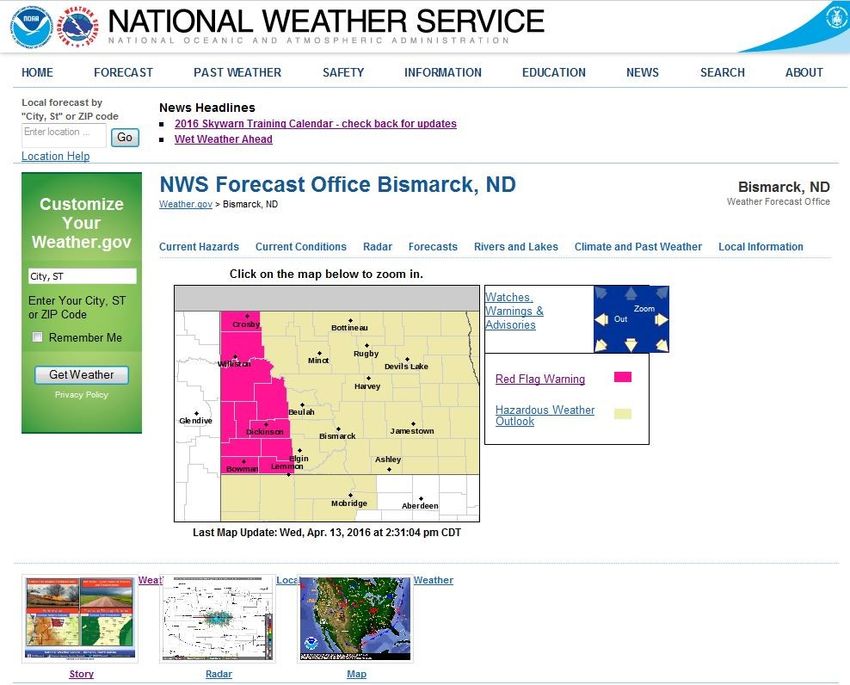
Severe Summer Weather and Wildfire Preparedness Guide                          Page ii

                                       Table of Contents

We Are StormReady! …………………………………………………………………………….                               1
CodeRED— Emergency Communications Network (ECN) ………………………………...                 2
IPAWS—Integrated Public Alert and Warning System ……………………………………..               3
Outdoor Warning Siren Facts …………………………………………………………………..                         4
Nature’s Most Violent Storms… Thunderstorms, Tornadoes and Lightning ……………..    5
Getting to Know Your Spring and Summer Weather Terms ………………………………..            6—7
How to Stay Informed! …………………………………………………………………………..                            8
Your “One Stop Shop” for Weather Information ……………………………………………...               9
Tornadoes… What Should You Do? ……………………………………………………………                         10
The Enhanced F Scale for Tornado Damage …………………………………………………..                  11
Tornado Safety in Schools ……………………………………………………………………….                         12
Lightning Kills—Play it Safe ……………………………………………………………………                        13
Lightning Facts ……………………………………………………………………………………                               14
Hailstorm Safety Measures ...…………………………………………………………………...                      15
Flood Safety Checklist …………………………………………………………………………...                         16
Septic Systems and Flooding …………………………………………………………………...                       17
Keeping the Public and Media Informed—ND Response ……….…………………………...            18
Wildfire Prevention Tips ………………………………………………………………………..                         19
Wildfire Prevention and Preparedness ………………………………………………………..                   20
Controlled Burn Procedures …………………………………………………………………….                         21
Household Fire Prevention ………………………………………………………………………                          22
Heat Wave Safety Checklist ..…………………………………………………………………….                       23
Heat Index and Heat Disorders …………………………………………………………………                        24
Fun in the Sun Safety… The UV Index ………………………………………………………...                   25
Safe Boating Weather Tips ……………………………………………………………………….                         26
Tips to Preventing Hypothermia ……………………………………………………………….                       27
Be Aware, Be Prepared… Make a Plan …………………………………………………………                      28
North Dakota One-Call ………………………………………………………………………….                            29
Emergency Phone Numbers (Handout) ………………………………………………………..                      30
Emergency Communications Plan …………………………………………………………….                         31
Additional Sources of Information ……………………………………………………………..                    32
Severe Summer Weather and Wildfire Preparedness Guide                                          Page 1

We are StormReady!

                          Morton County
                              is a

                     County
StormReady is a nationwide community preparedness program sponsored by the National Weather
Service (NWS) that uses a grassroots approach to help communities develop plans to handle all
types of severe weather. The program encourages communities to take a new proactive approach to
improving local hazardous weather operations by providing emergency managers with clear-cut
guidelines on how to improve hazardous weather operations.

StormReady communities are better prepared to save lives from the onslaught of severe weather by
way of better planning, education and awareness. No community is storm proof, but StormReady
can help communities save lives and protect property. In order to be officially certified by the NWS
as StormReady, a county or community must:

       ● Establish a 24-hour warning point and Emergency Operations Center (EOC).

       ● Have more than one way to receive severe weather forecasts and warnings to alert the
         public.

       ● Create a system that monitors local weather conditions.

       ● Promote the importance of public readiness through community outreach and seminars.

       ● Develop a formal hazardous weather plan, which includes training severe weather
         spotters and holding emergency exercises.

Morton County is one of 30 counties and the city of Mandan is one of 29 communities as well as the
Standing Rock Sioux Nation and 4 Universities in North Dakota recognized by the National
Weather Service as StormReady.

                            When seconds count, StormReady
                            communities are better prepared.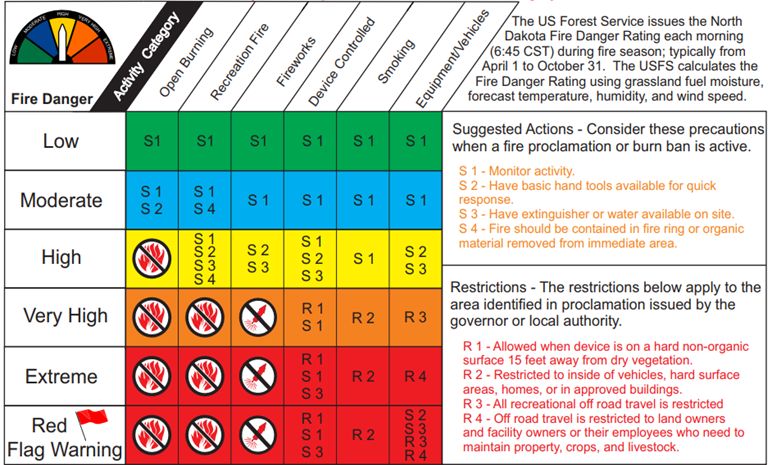
Severe Summer Weather and Wildfire Preparedness Guide                                                   Page 2

                            Emergency Communications Network (ECN):

 What is CodeRED?
 CodeRED is an Emergency Notification System that Morton County Agencies use to send out time
 sensitive information quickly and promptly.
 Morton County will use the CodeRED system to keep you informed of emergency information that may
 impact your safety by sending you telephone calls or text messages. Severe summer weather events that
 will trigger a CodeRED notification are; Severe Thunderstorm Warnings, Tornado Warnings and Flash
 Flood Warnings, etc.
 How do I sign up?
 Below are two links that will direct you to our Morton County Emergency Management webpage, that will
 provide more information about CodeRED, and then a link to the sign-up page for CodeRED. You can also
 call the Morton County Emergency Management office at (701) 667-3307 for help signing up.
 Morton County Emergency Management Webpage: http://tinyurl.com/jvhwo3u
 CodeRED Community Sign-Up: http://tinyurl.com/os2lmrz

 Note: When you do sign-up, please add the following phone numbers to your phone contacts in your
 mobile device so that you know that a CodeRED call is coming through. This will eliminate you thinking
 its’s a unknown caller or scam type call.
                                     CodeRED Emergency: 866-419-5000
                                      CodeRED General: 855-969-4636

 Frequently Asked Questions (FAQ):
 When will CodeRED be used?
 Any message regarding the safety of people, property, or welfare of the community will be disseminated
 using the CodeRED system. These may include missing person alerts, severe weather, tornado warning,
 hazardous materials alerts, and/or interruption/loss of utilities (water, electricity, etc.) in your area.
 Why did it leave only part of the message on my answering machine?
 CodeRED will leave a message on an answering device. There are many different brands and types of
 capturing devices for leaving a message. Occasionally something about the answering device or the beep of
 the device caused the system to think it has reached a live person and begins playing the message. When a
 message is left, it only leaves part of the message. If this occurs, you can call back 1-866-419-5000 and
 receive the entire message.
 Why did CodeRED call me several times?
 If there is no answer and you do not have an answering device, the number will be attempted up to 3 times
 to relay the message.
Severe Summer Weather and Wildfire Preparedness Guide Page 3
IPAWS—Integrated Public Alert and Warning System
What is IPAWS?
During an emergency, alert and warning officials need to provide the public with life-saving information
quickly. The Integrated Public Alert and Warning System (IPAWS) is a modernization and integration of the
nation’s alert and warning infrastructure and will save time when time matters most, protecting life and
property.
Federal, State, Local, Tribal, and Territorial alerting authorities can use IPAWS and integrate local systems
that use Common Alerting Protocol (CAP) standards with the IPAWS infrastructure. IPAWS provides
public safety officials with an effective way to alert and warn the public about serious emergencies using the
Emergency Alert System (EAS), Wireless Emergency Alerts (WEA), the National Oceanic and Atmospheric
Administration (NOAA) Weather Radio, and other public alerting systems from a single interface. Wireless
Emergency Alerts (WEA), made available through the Integrated Public Alert and Warning System (IPAWS)
infrastructure, are just one of the ways public safety officials can quickly and effectively alert and warn the
public about serious emergencies.
What you need to know about Emergency Alert Systems (EASs)?
The Emergency Alert System (EAS) is used by alerting authorities to send warnings via broadcast, cable,
satellite, and wireline communications pathways.
Emergency Alert System participants, who consist of broadcast, cable, satellite, and wireline providers,
are the stewards of this important public service in close partnership with alerting officials at all levels of
government.
The EAS is also used when all other means of alerting the public are unavailable, providing an added
layer of resiliency to the suite of available emergency communication tools.
The EAS is in a constant state of improvement to ensure seamless integration of CAP-based and emerging
technologies.
What you need to know about Wireless Emergency Alerts (WEAs)?
WEAs can be sent by State and Local public safety officials, the National Weather Service (NWS), the
National Center for Missing and Exploited Children, and the President of the United States.
WEAs can be issued for these categories – imminent local threats, AMBER, BLUE and SILVER alerts,
WEAs look like text messages, but are designed to get your attention and alert you with a unique sound
and vibration, both are repeated twice.
WEAs are no more than 90 characters, and will include the type and time of the alert, any action you
should take, as well as the agency issuing the alert.
WEAs are not affected by network congestion and will not disrupt texts, calls or
data sessions that are in progress.
Mobile users are not charged for receiving WEAs and there is no need to subscribe.
To ensure your wireless device is WEA-capable, check with your service provider.
Severe Summer Weather and Wildfire Preparedness Guide                                               Page 4

Outdoor Warning Siren Facts
With the chance of severe summer storms approaching, now is the time to familiarize
ourselves on the purpose and use of Outdoor Warning Sirens. Outdoor sirens are an
effective method of outdoor notification, however the system should not be relied
upon for early warning for individuals who are indoors. Air-conditioning, thunder,
high winds and rain can cause conditions for the sirens not to be heard when you are
indoors.

The city of Mandan has 7 active outdoor sirens and the cities of Almont, Flasher, Glen
Ullin, Hebron and New Salem each have sirens. These sirens can and will be activated
by the Morton County Sheriff’s Office Communications when the situation dictates.

                             When do the sirens sound?
Actual Events
       ● A confirmed funnel cloud has been spotted within 12 to 15 miles of your
         community.
       ● A confirmed tornado has been spotted within 12 to 15 miles of your
         community or
       ● The National Weather Service (NWS) has issued a Tornado Warning for
         Morton County or any of the specific cities in the track of the storm.
       ● The NWS predicts 80 mph wind gusts and/or golf ball (1.75 inch) or larger
         hail for Morton County to include the City of Mandan.

     IMPACT...PEOPLE AND ANIMALS OUTDOORS WILL BE INJURED.

Testing The outdoor warning sirens in Mandan are tested on the last Friday of each month at 9:30 a.m.
                                What should I do when the sirens sound?

Seek shelter by going indoors in a basement, cellar or lowest level of the building. Monitor local news
media (radio or television) for further information. If there is no basement, go to an inner hallway or
room away from windows such as a bathroom or closet. Vehicles, mobile homes, shopping malls and
auditoriums (any building with wide-span roofs) are not considered safe places to seek shelter.

              Please refrain from calling the 9-1-1 Center to find out what the emergency is.
                        Only call 9-1-1 if you have an actual emergency situation.

                               How can I receive NWS information when I’m indoors or sleeping?
                          A great individual preparedness tool is a NOAA Weather Radio (NWR)
                          which broadcasts continuous weather information 24 hours a day, 7 days a
                          week. This radio will provide alerts as soon as they are issued by the
                          National Weather Service.

                          See page 8 if this guide for more detailed information about NOAA Weather
                          Radios and their functions.
Severe Summer Weather and Wildfire Preparedness Guide                                     Page 5

Nature’s Most Violent Storms…Thunderstorms, Tornadoes and Lightning

                       Who’s Most At-Risk From Thunderstorms?

From Lightning…
       People who are outdoors, or anyone who stays outdoors when thunderstorms are nearby.

From Tornadoes… Nature’s Most Violent Storms
       People who are in campers, mobile homes or outdoors.

From Flash Floods and Flooding…
       People who walk or drive through flood waters.

From Large Hail…
       People who are caught outdoors.

                  Morton County Severe Storm Statistics (1950—2018)

Tornadoes: Total of 49. Deaths—2 in May 1953. Injuries—20 in May 1953. Highest rated tornado:
from 2007 to present— EF1 (86 to 110 mph) June 2010, 5.1 miles West-Southwest of Mandan airport.
No deaths or injuries. Grain bins destroyed and crop damage estimated at $250,000. Estimated
wind speeds were 95 mph. Highest rated tornado from 1950—2006: F5 (261 to 318 mph) May 1953,
near Fort Rice. There were 2 deaths and 20 injuries.

Wind Speed: Highest wind speed (non-tornadic thunderstorm gust) was 100 mph in June 1999, 2
miles east-southeast of St. Anthony. Damage resulted in 6 downed power lines.

Hail: Largest hailstone 4.50 inch diameter in July 1986. No listed location.

     The above data was compiled and provided by the National Weather Service
                               Office in Bismarck.
Severe Summer Weather and Wildfire Preparedness Guide Page 6
Getting to Know Spring and Summer Weather Terms
It’s important to become familiar and understand the National Weather Service (NWS) terms that
are frequently used in summer weather forecasts. If you are in the alerted area, check your TV or
listen to your local radio station or a weather radio for the most up-to-date information. Knowing
these key weather terms enables you to take the necessary precautionary measures during severe
summer weather. If you have a smartphone, weather applications are very useful.
WATCH— A product of the NWS indicating that conditions are favorable for the development of a
particular severe weather event. A watch is normally issued for several hours, 6 hours being the
most common. A watch indicates a need for planning, preparation and an increased awareness of
changing weather conditions. Typical “watches” include:
Severe Thunderstorm Watch
Tornado Watch
Flood Watch
Fire Weather Watch
WARNING— A product of the NWS indicating that a particular weather hazard is either imminent
or occurring. A warning indicates the need to take action to protect life and property. Typical
“warnings” include:
Severe Thunderstorm Warning
Tornado Warning
Flash Flood Warning
Red Flag Warning (Fire Danger)
WEATHER STATEMENTS— Issued as either “special or severe.” A special weather statement is
when the forecaster wants to pass information on to the public about developing or approaching
weather that is not expected to be severe, but nonetheless is significant. A severe weather statement
is used when a forecaster wants to follow up a warning with more specific information on the
progress, location, etc. of the severe weather warning that was originally issued.
FLOOD ADVISORY— Alerts the public to flooding which is generally only an inconvenience, not
life-threatening. Issued when heavy rain will cause flooding of streets and low-lying places. Also
used if small rural or urban streams are expected to reach or exceed the river/stream banks.
FLASH FLOOD WARNING— Signifies a dangerous situation where rapid flooding of rivers, small
streams or urban areas is imminent or is occurring. Very heavy rain that falls in a short time period
can lead to flash flooding, depending on local terrain, ground cover, degree of infrastructure and/or
man-made changes to river banks and initial ground or river condition.
The National Weather Service has issued a Severe Thunderstorm Warning for the following counties in ND—Burleigh;
Grant; Mercer; Morton; Oliver; Sioux; Stark; until 9:00 p.m. (CST), June 5, 2018. Stay tuned for updated reports.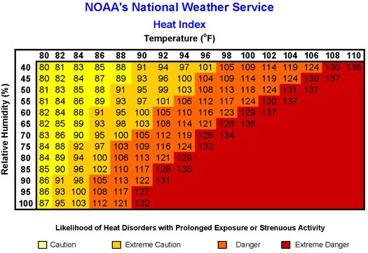
Severe Summer Weather and Wildfire Preparedness Guide                                            Page 7

Getting to Know Spring and Summer Weather Terms

SEVERE THUNDERSTORM WATCH— Conditions are favorable for the development of severe
thunderstorms in and close to the watch area. Watches are usually in effect for several hours, with 6
hours being the most common. Thunderstorms are accompanied by lightning and thunder and
usually with strong wind gusts, heavy rain and hail.

SEVERE THUNDERSTORM WARNING— Issued when a thunderstorm produces hail 1 inch or
larger in diameter and/or winds equal to or exceeding 58 mph. Severe thunderstorms can result in
the loss of life and/or property. Information in this warning includes: where the storm is, which
direction it is moving, what areas will be affected and the primary threat associated with the storm.

TORNADO WATCH— Conditions are favorable for the development of tornadoes in and close to
the watch area. Watches are usually in effect for several hours, with 6 hours being the most
common.

TORNADO WARNING— A tornado is indicated by radar or sighted by storm spotters. The
warning will include where the tornado is, which way it is moving, what areas will be impacted and
what those impacts could be.

RED FLAG WARNING— A term used by fire-weather forecasters, to call attention to weather
conditions of particular importance that would result in a rapid growth and spread of fire. A Fire
Weather Watch may be issued prior to the warning. The criteria for Red Flag events requires the
combination of high to extreme fire danger and critical fire weather pattern such as: dry lightning,
low relative humidity, very dry and unstable air, and very strong/shifting winds.
Severe Summer Weather and Wildfire Preparedness Guide                                         Page 8

How to Stay Informed!

    KEEP INFORMED
             OF
       THE STORM
      by listening to a
  NOAA Weather Radio,
 local radio, television or
cell phone applications for
 the latest summer storm
 advisories, watches and
        warnings in
         your area.

Radio, television and the internet are all good sources of weather data. However, if you want the
most accurate and timely information, go to the source itself. You can listen to a weather radio
designed to pick up broadcasts of the National Oceanic and Atmospheric Administration (NOAA).

Commonly referred to as, NOAA Weather Radio All Hazards (NWR), it provides continuous broad-
casts of the latest weather information directly from the local National Weather Service offices.
These broadcasts are tailored for your specific geographical area. The radios can be purchased from
many local outlet, electronic, and sporting goods stores and catalogs.

An important feature is that the NWR will automatically turn itself on to alert you when a watch or
warning has been issued, no matter what time of day or night. The newer radios can be pro-
grammed specifically for your county and some of the radios let you program specifically which
alerts/hazards you choose to receive.

The following National Weather Service Web site has additional information on the radios and their
programming codes: www.nws.noaa.gov/nwr

                                  NWS Statement = Get Ready

                                      NWS Watch = Get Set

                               NWS Warning = STOP what your
                                   doing and take action!
Severe Summer Weather and Wildfire Preparedness Guide Page 9
Your “One Stop Shop” for Weather Information
The Bismarck office of the National Weather Service provides a variety of daily weather products on
their Web site to inform the public of weather conditions and to help you prepare for weather
emergencies. If you are planning activities, this Web site will assist you preparing for “what’s
happening” or what’s predicted for the near future. We encourage you to visit this site and take a
look at the wide variety of meteorological data that is at your finger tips. The Web site is:
www.weather.gov/bis/Severe Summer Weather and Wildfire Preparedness Guide Page 10
Tornadoes… What Should You Do?
In the event of severe weather in your immediate area, first and foremost, stay tuned to local news media
outlets for warnings and/or listen to your weather radio or CodeRED notification messages .
In a House with a Basement: Avoid windows and get in the basement under sturdy protection. If possible
cover yourself with a mattress or sleeping bag. Know where heavy objects are located on the upper level
(e.g. pianos, refrigerators, waterbeds, etc.) and avoid being directly under them.
In a House with no Basement: Avoid windows. Go to the lowest floor, small center room, like a bathroom
or closet, under a stairwell, or in an interior hallway with no windows. Crouch as low as possible to the floor,
face-down and cover your head with your hands.
In an Apartment or Condo: If you live in an upper floor apartment, get to the lowest level that you can.
This could be either a neighbor’s first floor, basement apartment, or an underground parking garage. Then
move to the most interior area away from windows. If you live in a high-rise apartment building, and you
can’t get to a lower level, pick a place in the hallway in the center of your building such as a stairwell. If that
is not available, then a closet, bathroom or interior hall without windows is the safest place. Power loss
during a severe storm is common, so avoid using elevators and keep a flashlight handy.
In an Office Building, Hospital or Store: Follow the instructions provided from facility managers. Go
directly to an enclosed, windowless area in the center of the buildings lowest floor. Interior stairwells
provide good places for shelter. Avoid using elevators.
At a School: Follow the school’s designed storm drills. Go to the interior hallway or room in an orderly way
as instructed by the school staff. Crouch low, head down, and protect the back of your head with your arms.
Stay away from windows and large open rooms like gyms and auditoriums.
In a Vehicle: If the tornado is visible, far away, and the traffic is light, you may be able to drive away from its
path by moving at right angles to the tornado. Otherwise, park the vehicle as safely as possible out of traffic
lanes. Get out and seek shelter in a sturdy building. If in the open country, run to low ground away from
any vehicles. Lie flat and face-down, protecting the back of your head with your arms. Avoid seeking shelter
under bridges or in large culverts which can accelerate the wind speed and flying debris.
In the Open Outdoors: If possible, seek shelter in a sturdy building. If not, lie flat and face-down on low
ground, protecting the back of your head with your arms. Get as far away from the trees and vehicles as you
can.
In a Church or Theater: If possible, move quickly but orderly to an interior bathroom or hallway, away from
windows. Crouch face-down and protect your head with your arms. If there is no time to do that, get under
the seats or pews, protecting your head with your arms and hands.
In a Mobile Home: GET OUT! Even if your home is tied down, you are probably safer outside, even if the
alternative is to seek shelter out in the open. Most tornadoes can destroy even tied-down mobile homes. If
there is a sturdy permanent building within easy running distance, seek shelter there. If you don’t have
transportation to public tornado shelters, make pre-arrangements for someone to drive you. If you have
friends or relatives in the close proximity with basements, make arrangements to shelter with them. Also,
always check with the mobile home park property managers to determine what plans are in place for tornado
sheltering.
The City of Mandan has identified public tornado shelters at the Morton County
Courthouse and Mandan City Hall. If conditions permit, go there fast.Severe Summer Weather and Wildfire Preparedness Guide Page 11
The Enhanced F Scale for Tornado Damage
The National Weather Service uses the Enhanced F-Scale to assign a tornado a “rating” based on
estimated wind speeds and related damage caused by the tornado.
EF Rating 3 Second Wind Gust (MPH) TYPICAL DAMAGE
Light Damage: Some damage to chimneys;
0 65-85 mph branches breaking off trees; shallow rooted
trees pushed over; sign boards damaged.
Moderate Damage: Peels surface off roofs;
1 86-110 mph mobile homes pushed off foundations or over-
turned; moving vehicles blown off roads.
Significant Damage: Roofs torn off frame
houses; mobile homes demolished; boxcars
2 111-135 mph overturned; large trees snapped or uprooted;
light-object debris/projectiles generated;
vehicles lifted off the ground.
Severe Damage: Roofs and some walls torn off
well-constructed houses; trains overturned;
3 136-165 mph
most trees in forested areas uprooted; heavy
vehicles lifted off the ground and thrown.
Devastating Damage: Well-constructed houses
leveled; structures with weak foundations
4 166-200 mph
blown away some distances; vehicles thrown
and large debris/projectiles generated.
Incredible Damage: Strong frame houses
leveled off foundations and swept away;
5 201 + mph automobile-sized projectiles fly through the air
in excess of 10 yards; trees debarked; incredible
phenomena will occur.Severe Summer Weather and Wildfire Preparedness Guide Page 12
Tornado Safety in Schools
Every School Should Have a Severe Weather Safety Plan
Develop a severe weather safety plan that ensures everyone will take
cover within 60 seconds. Conduct frequent tornado drills. Include
provisions for all after-hours, school related activities.
Every school should be inspected and tornado shelter areas designated by a registered engineer
or architectural firm. Rooms with exterior walls should never be used as tornado shelters.
Basements offer the best protection. Schools without basements should use interior rooms and
hallways on the lowest floor, away from windows.
Delay lunches and assemblies in large rooms if severe weather is anticipated. Rooms with large
roof spans (e.g. gymnasiums, cafeterias and auditoriums) offer little protection from tornado-
strength winds.
Ensure students and staff know the protective position (as shown here).
Everyone should kneel facing an interior wall, elbows to knees, and with
hands over the back of their heads.
Each school should have a NOAA Weather Radio with battery back-up.
Note, the NWS issues a “Tornado Watch” when conditions are favorable for tornado development
and a “Tornado Warning” when a tornado has been spotted or indicated by weather radar.
If the school’s alarm system relies on electricity, have an alternative method to notify teachers
and students in case of power failure.
Make special provisions for faculty and students with disabilities, those in portable classrooms
and those outdoors. They should be notified first of approaching severe weather.
Keep children at school beyond regular hours during a “Tornado Warning.” School bus drivers
should identify protective areas along each part of their route they and their passengers can take
cover if overtaken by a tornado or high winds.
Include properly designed tornado shelters when planning additions or new school buildings.
Somewhere Elementary
School Hospitals, nursing homes
and other institutions
should develop similar
severe weather safety plans.
= “BEST AVAILABLE” Tornado ShelterSevere Summer Weather and Wildfire Preparedness Guide Page 13
Lightning Kills—Play it Safe
There is no safe place outside in a thunderstorm. If you hear thunder, lightning is close enough to
strike you. Plan ahead to avoid this dangerous situation! If you are outside and hear thunder, the
only way to significantly reduce your risk of becoming a lightning casualty is to get inside a substan-
tial building or hard-topped metal vehicle as fast as you can. In addition you should avoid the
following situations which could increase your risk of becoming a lightning casualty.
Remember—there is no substitute for getting to a safe place.
Caught in a Thunderstorm—What You Should Know
► Avoid open areas—Don’t be the tallest object in the area. Get off elevated areas such as hills,
ridges or peaks.
► Get out and off bodies of water—Immediately get out and away from ponds, lakes and other
bodies of water.
► Stay away from isolated tall trees, towers or utility poles—Lightning tends to strike the taller
objects in an area.
► Stay away from metal conductors such as wires or fences—Metal does not necessarily attract
lightning, but lightning can travel long distances through it.
► As a group of people, spread out—While this actually increases the chance that someone might
get struck, it tends to prevent multiple casualties, and increases the chances that someone could
help if a person is struck.
Act Fast If Someone Is Struck By Lightning!
► Lightning victims do not carry an electrical charge, are safe to touch and need urgent medical
attention—Cardiac arrest is the immediate cause of death. Some deaths can be prevented if the
victim receives the proper first aid immediately.
► Call for help—Call 9-1-1 or contact on-site medical personnel.
► Give first aid—Do not delay giving CPR if the person is unresponsive or not breathing. Use an
Automatic External Defibrillator (AED) if one is available.
When Should Activities be Stopped and Resumed?
► The sooner the activities are stopped and people get to a safe place, the better.
► In general, a significant lightning threat exists from the base of a thunderstorm 6 to 10 miles.
Therefore, people should move to a safe place when a thunderstorm is 6 to 10 miles away.
Use the “30-30 Rule”
► If the time between seeing lightning and hearing corresponding thunder is 30 seconds or less,
this indicates the thunderstorm is 6 miles or less and lightning is close enough to hit you.
► Because electrical charges can linger in clouds after a thunderstorm has passed, experts agree
that you should wait 30 minutes after the storm to resume activities.
Remember, When the Thunder Roars, Go Indoors!Severe Summer Weather and Wildfire Preparedness Guide Page 14
Lightning Facts
Lightning is hotter than the surface of the sun and can reach
temperatures around 50,000 degrees Fahrenheit.
How Far Away Is the Lightning?
Count the number of seconds between a flash of lightning and the sound of the resulting thunder,
The “Flash to Bang” method.
Then divide this number by 5 to get an estimate of the distance in miles to the lightning strike.
Example: If you see lightning and it takes 10 seconds before you hear the thunder, then the lightning is
2 miles away from you (10 divided by 5 = 2 miles).
Remember if you are outdoors and can hear thunder, you are in danger of being struck by lightning.
Lightning Myth and Fact
MYTH: If it is not raining, or there aren’t clouds overhead, you’re safe from lightning.
Lightning often strikes more than 3 miles from the center of a thunderstorm and may occur as
FACT: far as 10 miles away from any rainfall. This is especially true in some parts of the state where
thunderstorms sometimes produce very little rain.
MYTH: The rubber tires on a car will protect you from lightning by insulating you from the ground.
Most cars are safe from lightning, but it is the metal roof and sides that protect you NOT the
FACT: rubber tires. Do not lean on vehicle doors during a storm. Although you may be injured if
lightning strikes your car, you are much safer inside a vehicle than outside.
MYTH: People struck by lightning should not be touched because they carry an electrical charge.
Lightning-strike victims DO NOT carry an electrical charge and should be helped
immediately. Anyone who has been hit by lightning requires immediate professional medical
FACT:
care. Call 9-1-1 and begin CPR immediately if the person has stopped breathing. Use an
Automatic External Defibrillator (AED) if one is available.
MYTH: If trapped outside and lightning is about to strike, I should lie flat on the ground.
Lying flat increases your chance of being affected by potentially deadly ground current. If you
FACT:
are caught outdoors in a thunderstorm, keep moving to a safe shelter ASAP.
MYTH: Lightning never strikes the same place twice.
Lightning often strikes the same place repeatedly, especially if it’s a tall, pointy, isolated object.
FACT:
For example, the Empire State Building is struck by lightning an average of 23 times a year!Severe Summer Weather and Wildfire Preparedness Guide Page 15
Hailstorm Safety Measures
Do you know what to do in a hailstorm?
Summer hailstorms can be violent and destructive. Usually occurring in the late afternoon or early
evening after a hot day, these storms are accompanied by thunder, lightning, high winds and often
flash floods. A hail storm, on average, only lasts about six minutes.
Hail Size Estimates (in diameter)
Marble/Moth Ball = 1/2 inch Half Dollar = 1-1/4 inches Tennis Ball = 2-1/2 inches
Penny = 3/4 inch Ping Pong Ball= 1-1/2 inches Baseball = 2-3/4 inches
Nickel = 7/8 inch Golf Ball = 1-3/4 inches Large Apple = 3 inches
Quarter = 1 inch Hen Egg = 2 inches Softball = 4 inches
…in an automobile: …in a building: …outdoors:
● Stop driving. If you can see ● Seek shelter immediately ● If you are caught outdoors,
a safe place close-by to drive in a sturdy building. Stay seek shelter immediately.
to (like inside a garage or inside until the hail stops. If you can’t find something
under a service station to protect your entire
awning), do so as soon as ● Stay away from skylights body, at least find some-
possible. If on a highway, and windows, especially thing to protect your head.
make sure you pull com- windows that are being
pletely off the highway. struck by hail. ● Stay out of culverts and
lowland areas that might
● Do NOT leave the vehicle ● Account for all family suddenly fill or flood with
until it stops hailing. Your members, building occu- water.
car will provide reasonable pants, pets, etc. Do not go
protection. outside for any reason. ● Trees are a last resort. It is
Large hail can cause seri- common during severe
● Stay away from car win- ous, or even fatal injuries. storms for trees to loose
dows. Cover your eyes with branches. Also, large
something (piece of clothing ● Avoid using phones and isolated trees attract
or blanket) or lay down on electrical appliances dur- lightning.
the seat with your back to ing a severe storm to avoid
the windows. Put very the danger of electrocution
small children under you, from lightning.
and cover their eyes.
Large hailstones can fall at speeds faster than 100 mph!Severe Summer Weather and Wildfire Preparedness Guide Page 16
Flood Safety Checklist
Know the Difference
Flash floods occur suddenly (usually less than Flood/Flash Flood Watch—Flooding or flash
6 hours) due to rapidly rising water along flooding is possible in your area.
streams or low-lying areas. Conditions that
Flood/Flash Flood Warning—Flooding or flash
cause floods include heavy or steady rain for flooding is already occurring or will occur in your
several hours or days that saturates the soil. area.
What should I do? What supplies do I need? What do I do after a flood?
● Listen to local radio/TV stations ● Water—at least a 3-day supply; ● Return home only when local offi-
and a NOAA Weather Radio. one gallon per person per day. cials have declared the area safe.
● Be prepared to evacuate at a ● Food—at least a 3-day supply of ● Parts of your home may be dam-
moments notice. non-perishable easy to prepare aged or collapsed. Approach
food. Baby supplies as needed. entrance carefully. See if porch
● When a flood/flash flood warning roofs and overhangs have all their
is issued, head for higher/safe ● Flashlights and battery powered supports.
ground and stay there. radio. (NOAA Weather Radio, if
possible). Extra batteries for each. ● If you smell natural or propane gas
● Stay away from floodwaters. If or hear a hissing noise, leave imme-
you come upon a flowing stream ● Medications (7 day supply) and diately and call 9-1-1.
where water is above your ankles, other medical items needed.
stop, turn around and go another ● Keep children and pets away from
way. Six inches of swiftly moving ● Sanitation and personal hygiene hazardous sites and floodwater.
water can sweep you off your feet. items.
● Material such as cleaning products,
● If you come upon a flooded road ● Cell phone with chargers. paints, batteries and contaminated
while driving, turn around and go fuel are hazardous materials. Check
another way. If you are caught in a ● Family and emergency contact with local authorities for assistance
flooded road and water is rising information. with disposal to avoid risk.
rapidly, get out of the car and
quickly move to higher ground. ● Extra cash. ● During cleanup, wear protective
Most cars can be swept away by clothing, including rubber gloves,
less than two feet of moving water. ● Extra clothing items. rubber boots and breathing masks.
● Keep children out of water. They ● Pet supplies (collar, leash, ID tag, ● Make sure food and water are safe.
are curious and often lack judg- food, medications and carrier). Discard items that have come into
ment about running or contaminat- contact with floodwater, including
ed water. ● Extra set of car keys and house canned goods, water bottles, plastic
keys. utensils, and baby bottle nipples.
● Be especially cautious at night When in doubt, throw it out!
when it is harder to recognize ● Camera for photos of damage.
flood dangers. ● Do not use water that could be con-
taminated to wash dishes, brush
● Because standard homeowners teeth, prepare food, wash hands,
insurance doesn’t cover flooding, make ice or make baby formula.
it’s important to have extra protec-
tion for flooding. For more infor- ● Contact your local public health
mation on flood insurance, visit the department for specific recommen-
National Flood Insurance Program dations on treating water and clean-
Web site at www.FloodSmart.gov. up procedures.Severe Summer Weather and Wildfire Preparedness Guide Page 17
Septic Systems and Flooding
Flooding can cause problems for homes with individual septic/drain field systems. If drains in the
house run slowly or are backing up, pumping the septic tank will provide at best three or four days
of reprieve, but the problem will return. The saturation of soil in the drain field area from surface
flooding doesn’t allow for surface evaporation or natural soil percolation, thus the drain field
remains saturated with waste water. This causes water to back-up throughout the entire home
sewer system.
If your drain field area is flooded or very saturated you might notice some of the following issues:
● Drains in the house will run slow.
● Toilets drain slowly or sound strange when flushed.
● Water may back-up into floor drains in the basement.
Under flooded or saturated drain field conditions, do not have the septic tank pumped! At best,
pumping the tank is only a temporary solution. Under the worst conditions, pumping it could
cause the tank to try to float out of the ground and damage the inlet and outlet pipes.
What you can do to minimize the problem?
The best solution is to plug all drains in the basement and drastically reduce water use in the house.
Some suggested ways:
● Don’t put water from a basement sump pump into the septic system.
● Don’t let water from roof gutters or sump pump discharge onto the drain field area.
● Reduce the number of times you flush the toilet. A good rule might be to limit one flush
per person per day.
● Reduce the number of showers and baths.
● Don’t use the garbage disposal or dishwasher.
● Don’t do laundry, use a Laundromat if possible.
Common sense is the key to reducing water use in the home. Remember, the drain field was
designed to infiltrate the amount of water normally discharged from the house. When additional
water from rain, snow, or flooding is added to the drain field, its ability to handle household water
becomes seriously limited.Severe Summer Weather and Wildfire Preparedness Guide Page 18
Keeping the Public and Media Informed—ND Response
www.ndresponse.gov
In the event of major or current incidents impacting North Dakota citizens, the state uses the
website NDResponse.gov to provide a single source of accurate and timely information. Through
NDResponse.gov, the state can streamline the delivery of information to the public and media,
helping to ensure a accurate and consistent message in situations where multiple agencies or
branches of government are involved.
When there is no specific or active incident, the website will simply direct users/viewers to
individual agency websites. The homepage contains drop down menus, as shown below:
These are the current specific events/incidents for the user to open and find valuable information
and resources as needed.
Drought—Information on predicted or current drought conditions and resources as needed.
Fire Danger—Contains information pertinent to burn ban restrictions and fire danger maps.
Public Awareness—Useful information for the public regarding preparedness and safety
measures relating to severe weather, flood preparedness, fire safety and shelter-in-place
guidelines.
Public Alerts—Explains the various statewide alerts going to the media and public as needed.
These alerts are Amber, Silver and Blue Alerts for assistance from the public.
Archive—Information relevant and recorded from past emergencies/events in North Dakota.
Contact— Helpful instructions on how to contact NDResponse to include other points of contact
for further assistance.Severe Summer Weather and Wildfire Preparedness Guide Page 19
Wildfire Prevention Tips
Did you know?
Most wildfires are caused by lightning during
extreme dry weather or drought conditions.
However, an alarming number of fires are ignited by acts of
human carelessness. Here are some helpful tips to follow:
What is the safest way to build, maintain and extinguish a campfire?
● Check the ND Fire Danger Rating (see Web site on page 20 of this guide) to determine the fire
category for the day you are having a campfire to see if campfires are restricted or prohibited.
● Clear campfire site down to bare soil and circle the campfire pit with rocks/bricks.
● Build campfires away from overhanging branches, steep slopes, dry grass, leaves and debris.
● Keep a bucket of water and a shovel nearby.
● Never leave a campfire unattended.
● When putting out the campfire, drown the fire with water, stir, and drown it again.
● Always have an adult present to supervise outdoor fires/cooking.
● Be careful with gas lanterns, grills, gas stoves and anything that can be a source of ignition.
Where can I use fireworks on public lands?
● The use of fireworks is strictly prohibited on ALL Federal and State public lands. (NOTE— The
use of Luminary Fireworks are now prohibited in the Mandan City limits.)
What is the safest way to burn trash?
● Check the ND Fire Danger Rating to determine the fire category for the day you want to burn to
see if open burning is restricted or prohibited by a local burn ban.
● Burn trash in a safe incinerator that includes: Heavy mesh screen with holes not much larger than
1/4 inch, and a metal barrel in good condition.
● Clear the area of flammable material at least 10 feet around the incinerator.
How do I safely operate an on or off-road vehicle on public lands when the fire potential is high?
● Check the ND Fire Danger Rating for local conditions to see if off-road travel is restricted or
prohibited due to fire conditions.
● Avoid driving and parking your vehicle in tall dry grass.
● Never throw a lit cigarette out the window of a vehicle.
● Grease trailer wheels, check tires and ensure safety chains are not touching the ground.
● All off-road vehicles require a spark arrester and should be checked and cleaned periodically.
● Carry a shovel and fire extinguisher in your vehicle or Off Highway Vehicle (OHV)/All Terrain
Vehicle (ATV).
What can kids do to help prevent wildfires?
● Never let children play with matches, lighters, flammable liquids or any fire.
● Educate your children and friends about fire prevention in the outdoors.
● Stay calm during an emergency, and listen to instructions from parents or another person who is
in charge during outdoor activities.Severe Summer Weather and Wildfire Preparedness Guide Page 20
Wildfire Prevention and Preparedness
It’s common practice in North Dakota during spring, summer and fall to burn fields, trees and
debris in agricultural and rural settings. Another common practice is for outdoor enthusiasts to
build campfires while enjoying the state’s outdoor recreational opportunities. For increased
awareness and to greatly reduce the chance that rural fires will threaten lives and property, the U.S.
Forest Service issues the North Dakota Fire Danger Ratings from April to October annually.
North Dakota Fire Danger Rating
This Rating serves as a guide to reduce the number of uncontrollable outdoor fires. The Rating is a
forecast of fire potential for grasslands, including its ability to spread. The rating contains six
levels: Low, Moderate, High, Very High and Extreme and Red Flag Warning. The U.S Forest Ser-
vice calculates the Fire Danger Rating for each county daily, using vegetative greenness and fore-
cast temperature, humidity and wind speed and posts this information to the National Weather Ser-
vice (NWS) and Department of Emergency Services (DES) Web site.
www.nd.gov/des
First Offense of a burn ban is a Class B misdemeanor:
up to 30 days in jail and a $1,500 fine.Severe Summer Weather and Wildfire Preparedness Guide Page 21
Controlled Burn Procedures
Morton County Controlled Burn Procedures
The Morton County Office of Emergency Management has issued the following procedures for
landowners, contractors, equipment operators and outdoor enthusiasts when engaged in open area
controlled burning situations. These precautions are to ensure that open burning is coordinated
with the proper authorities for maximum safety to people and property.
● Check with your Fire Chief for the Fire District where you desire to conduct the open
burning.
● Citizens should contact the Morton County Sheriff’s Office Communications at 667-3405
before a controlled burn is started so that emergency responders are not dispatched for
reports of fire, when in fact it is a controlled burn. Be prepared to give your name, contact
number, location of controlled burn and anticipated duration of the burn. After the burn-
ing is completed and the fire is out, again contact the Morton County Sheriff’s Office
Communications (667-3405) to inform them of the completion.
● Controlled burns need to be physically monitored at all times. Once the fire has been
started, do not leave the site unattended until the fire is completely out.
● Be prepared if the fire gets out of hand. Call 9-1-1 immediately and have resources
available to mitigate the effects (e.g. tractor, digger, shovels, water, etc.).
Residents are urged to follow the precautions as listed in the outdoor activity guidelines for the five
fire danger ratings (Low, Moderate, High, Very High and Extreme) on page 22 of this guide.
Open burning is prohibited when the Fire Danger Rating is in the
High, Very High, and Extreme and Red Flag Warning Category.
Pre-burn Checklist
Are there any local restrictions or burn bans for my city/county?
Have I looked at the weather for the day of the burn and the next day?
Have I notified the proper authorities prior to burning?
Do I have a plan if the fire gets away and have I communicated the plan to those helping me?
Do I have adequate water/equipment/people to help keep the fire under control?
Does the burn area pose potential danger to other persons and property?
Do I have a large enough clear zone?
Am I willing to take legal and financial responsibility if the fire gets away?
Am I adequately insured to cover potential liability and/or losses?Severe Summer Weather and Wildfire Preparedness Guide Page 22
Household Fire Prevention
Fire Prevention If Fire Strikes
● Make sure your house number is clearly ● If there is a fire—evacuate and call 9-1-1
visible for firefighters to see and read. from a cell phone or your neighbors house.
● Install smoke detectors outside all sleeping ● Never use water on an electrical fire.
areas or in each bedroom and on every level
of your home, including the basement. ● If caught in smoke, drop to your hands and
knees and crawl. Breathe shallowly
● Install A-B-C type fire extinguishers and through your nose and use clothing or cloth
teach each family member how to use them. as a filter.
● Check smoke detectors on a regular basis ● If you are forced to advance through flames,
and replace the batteries twice a year. A hold your breath, move quickly, cover your
good schedule is during the spring and fall head and hair, keep your head down and
time changes. close your eyes as much as possible.
● Be familiar and know the locations of all ● If your clothes catch fire, “Stop—Drop and
exits, including windows. Roll” until the fire is out.
● Plan an escape. Know two ways out of ● Smother oil and grease fires in the kitchen
every room in case flames/smoke block the with baking soda or salt and put a lid over
primary exit. the flame to starve the oxygen. Never
throw water on an oil/grease fire.
● Choose a meeting place outside the home
and account for all family members. If ● If you’re are in a room and cannot escape,
someone is missing, let the fire department close the door, stay low to the floor and talk
know, don’t go back inside. to firefighters to signal your presence.
● Mark bedroom windows outside of the
building of children and others who may
not be able to self-rescue.
● Learn how to turn off gas and electricity in
an emergency.Severe Summer Weather and Wildfire Preparedness Guide Page 23
Heat Wave Safety Checklist
How Can I Prepare? What Should I Do Recognize and Care For
During a Heat Wave? Heat Related Emergencies…
● Listen to local weather forecasts
and stay aware of upcoming ● Listen to the NOAA Weather Radio ● Don’t get too much sun.
temperature changes. for critical updates from the NWS. Sunburn makes the job of heat
dissipation by the body much
● The heat index is the temperature ● Never leave children or pets alone more difficult.
the body feels when the effects of in enclosed vehicles.
heat and humidity are combined. ● Sunburn Redness of the exposed
Exposure to direct sunlight can skin and pain. In severe cases,
increase the heat index by as much
● Stay hydrated by drinking plenty of
fluids even if you don’t feel thirsty. you will have swelling of skin,
as 15 ° F. blisters, fever and headaches.
Avoid drinks with alcohol or
caffeine.
● Discuss heat safety precautions ● Heat Cramps are muscular pains
with members of your family. and spasms that usually occur in
● Eat small meals and eat more often.
the legs and abdomen caused by
● Know those in your neighborhood exposure to high heat and high
● Wear loose-fitting, lightweight, light
who are elderly, young, sick or humidity and loss of fluids and
colored clothing. Avoid dark colors
overweight. They are more likely electrolytes. Heat cramps are
because they absorb the sun’s rays.
to become victims of excessive heat often an early sign that the body
and may need assistance. is having trouble dealing with
● Slow down physical activity, stay the heat.
indoors if possible, and avoid stren-
● If you do no have air conditioning,
uous activity during the hottest part
choose places you could go for
of the day.
● Heat Exhaustion typically
relief from the heat during the involves the loss of body fluids
warmest part of the day (schools, through heavy sweating during
libraries, theaters, malls, etc.). ● Use a buddy system when working strenuous exercise or physical
in excessive heat.
labor in high heat and humidity.
● Get trained in first aid to learn how
to treat heat-related emergencies.
● Take frequent rest breaks if you ● Heat Stroke (also known as
must work outdoors.
sunstroke) is a life-threatening
● Ensure that animal’s needs for condition in which a person’s
water and shade are met.
● Check on family, friends and neigh- body temperature control system
bors who spend much of their time stops working and the body is
alone or who are more likely to be unable to cool itself.
affected by the heat.
● Refer to the Heat Disorder
● Check on your animals frequently Symptoms Chart on page 25 of
to ensure they are not suffering this guide.
from the heat.You can also read