SEYMOUR, CT Hazard Mitigation Plan Update - Naugatuck ...
←
→
Page content transcription
If your browser does not render page correctly, please read the page content below
Naugatuck Valley Council of Governments
               Hazard Mitigation Plan Update
                                     2021 – 2026

                                    Municipal Annex
                                          for

                               SEYMOUR, CT

                                             1 First Street
                                          Seymour, CT 06483
                                            MMI #3211-29

               Prepared for:                                         Prepared by:
NAUGATUCK VALLEY COUNCIL OF GOVERNMENTS                           SLR CONSULTING
      47 Leavenworth Street, 3rd Floor                              99 Realty Drive
           Waterbury, CT 06702                                Cheshire, Connecticut 06410
              (203) 489-0362                                        (203) 271-1773
             www.nvcogct.org                                    www.slrconsulting.com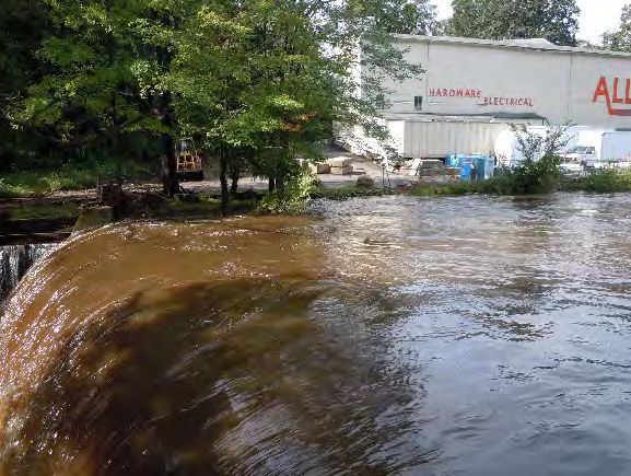
TABLE OF CONTENTS
1.0      INTRODUCTION ......................................................................................................................................... 1-1
  1.1       PURPOSE OF ANNEX .................................................................................................................................... 1-1
  1.2       PLANNING PROCESS .................................................................................................................................... 1-1
  1.3       PHYSICAL SETTING ...................................................................................................................................... 1-1
  1.4       LAND COVER ............................................................................................................................................. 1-2
  1.5       GEOLOGY .................................................................................................................................................. 1-2
  1.6       CLIMATE AND CLIMATE CHANGE .................................................................................................................... 1-3
  1.7       DEVELOPMENT TRENDS ................................................................................................................................ 1-5
  1.8       HISTORIC AND CULTURAL RESOURCES .............................................................................................................. 1-6
  1.9       SOCIAL VULNERABILITY INDEX ........................................................................................................................ 1-6
2.0      MUNICIPAL CAPABILITIES .......................................................................................................................... 2-7
  2.1       GOVERNMENTAL STRUCTURE AND CAPABILITIES................................................................................................. 2-7
  2.2       INFRASTRUCTURE ...................................................................................................................................... 2-12
  2.3       CRITICAL FACILITIES AND EMERGENCY RESPONSE.............................................................................................. 2-12
3.0      FLOODING ............................................................................................................................................... 3-15
  3.1       EXISTING CAPABILITIES ............................................................................................................................... 3-15
  3.2       VULNERABILITIES AND RISK ASSESSMENT ........................................................................................................ 3-16
4.0      HURRICANES AND TROPICAL STORMS .................................................................................................... 4-20
  4.1       EXISTING CAPABILITIES ............................................................................................................................... 4-20
  4.2       VULNERABILITIES AND RISK ASSESSMENT ........................................................................................................ 4-21
5.0      SUMMER STORMS AND TORNADOES ..................................................................................................... 5-22
  5.1       EXISTING CAPABILITIES ............................................................................................................................... 5-22
  5.2       VULNERABILITIES AND RISK ASSESSMENT ........................................................................................................ 5-22
6.0      WINTER STORMS ..................................................................................................................................... 6-24
  6.1       EXISTING CAPABILITIES ............................................................................................................................... 6-24
  6.2       VULNERABILITIES AND RISK ASSESSMENT ........................................................................................................ 6-24
7.0      GEOLOGICAL HAZARDS ........................................................................................................................... 7-25
  7.1       EXISTING CAPABILITIES ............................................................................................................................... 7-25
  7.2       VULNERABILITIES AND RISK ASSESSMENT ........................................................................................................ 7-25
8.0      DAM FAILURE .......................................................................................................................................... 8-27
  8.1       EXISTING CAPABILITIES ............................................................................................................................... 8-27
  8.2       VULNERABILITIES AND RISK ASSESSMENT ........................................................................................................ 8-27
9.0      WILDFIRES ............................................................................................................................................... 9-32
  9.1       EXISTING CAPABILITIES ............................................................................................................................... 9-32
  9.2       VULNERABILITIES AND RISK ASSESSMENT ........................................................................................................ 9-32
10.0     MITIGATION STRATEGIES AND ACTIONS ............................................................................................... 10-34
  10.1      GOALS AND OBJECTIVES ........................................................................................................................... 10-34
  10.2      STATUS OF MITIGATION STRATEGIES AND ACTIONS FROM PREVIOUS HMP .......................................................... 10-34
  10.3      PRIORITIZATION OF STRATEGIES AND ACTIONS ............................................................................................... 10-39
  10.4      MITIGATION STRATEGIES AND ACTIONS IMPLEMENTATION TABLE ...................................................................... 10-40

Municipal Annexes: Seymour

1.0 INTRODUCTION
1.1     Purpose of Annex

This Hazard Mitigation Plan (HMP) annex provides a community-specific hazard risk assessment, capability
analysis, and evaluation and prioritization of hazard mitigation measures and projects.

Background information and the regional effects of pertinent natural hazards are discussed in the main
body of the Naugatuck Valley Council of Governments (NVCOG) Multi-Jurisdictional Hazard Mitigation Plan.
This annex is designed to supplement the information presented in the Multi-Jurisdictional HMP with more
specific local detail, and is not to be considered a standalone document.

The primary goal of this HMP, including this Municipal Annex, is to identify natural hazard risks and
mitigation opportunities in order to reduce the loss of or damage to life, property, infrastructure, and
natural, cultural, and economic resources. This includes the reduction of public and private damage costs.
Limiting losses of and damage to life and property will also reduce the social, emotional, and economic
disruption associated with a natural disaster.

1.2     Planning Process

A meeting was held with Seymour representatives on Provided comments and feedback via email for the
purposes of initial data collection and review of necessary updates for this document. The meeting was
convened by the HMP local coordinator, Thomas Eighmie.

Additional input was provided at the two regional municipal staff workshops, held on November 18, 2020,
and February 3, 2021.

Public input collected at public workshops and through an online survey have also informed development
of this HMP update.

1.3     Physical Setting

Seymour lies within the region of Connecticut called the "Naugatuck River Valley," which extends from
Torrington to Derby and includes the city of Waterbury. The Route 8 corridor and the Waterbury branch of
the Metro-North railroad line span this region. The "Lower Naugatuck Valley" is sometimes known to
include the towns of Oxford, Bethany, Beacon Falls, and Woodbridge in addition to Ansonia, Derby, and
Seymour.

In general, the topography of the region increases in elevation moving from the shorelines of the major
rivers (the Housatonic and Naugatuck Rivers, which are nearly at sea level) to the east and/or west of either
river. Within the region, elevations of 500 feet or greater are found along western and southwestern
Seymour and western Shelton while there are a few other smaller, more concentrated areas of this elevation
in northern and eastern Seymour and northeastern Ansonia.

NVCOG Hazard Mitigation Plan Update             1-1
August 2021

Municipal Annexes: Seymour

Seymour has a peak of approximately 640 feet in the southwestern part of the town on Great Hill along
Route 334/Great Hill Road. The areas with greatest relief are found in southwestern Seymour (at Great Hill)
where elevations of 630 feet to 640 feet can be found.

1.4     Land Cover

A high-density industrial center was developed in the 19th and 20th centuries in downtown Seymour. A
decrease in developed land cover is evident with greater distance from either river. The majority of the rural
and farmland cover is found in southwest Seymour. Despite its urban core, the Town is suburban on the
whole, with populations that flourished during the last century as Connecticut's highway network was
superimposed on the Town’s historical industrial center.

The northern portion of Seymour is predominantly forested. Agricultural land use is distributed sparsely
throughout Seymour. Although residential land uses are interspersed throughout the Town, higher density
residential and nonresidential land uses are situated near the Naugatuck and Housatonic Rivers and the
Route 8 corridor.

Table 1-1 summarizes 2015 land cover data which was derived from satellite imagery. Areas shown as turf
and grass are maintained grasses such as residential and commercial lawns or golf courses. According to
this data, about 53% of Seymour is forested and approximately 28% is developed.

                                   Table 1-1: 2015 Land Cover by Area
                            Land Cover          Area (acres)    Percent of Community
                            Developed             2,683.6               28.06%
                           Turf & Grass           1,021.8               10.68%
                           Other Grass             169.4                 1.77%
                        Agricultural Field         201.8                 2.11%
                        Deciduous Forest          4,492.3               46.97%
                        Coniferous Forest          471.3                 4.93%
                               Water               318.2                 3.33%
                      Non-Forested Wetland           8.0                 0.08%
                        Forested Wetland            91.4                 0.96%
                          Tidal Wetland              0.0                 0.00%
                              Barren               107.3                 1.12%
                            Utility Row              0.0                 0.00%
                               Total               9,565                 100%
                      Source: UCONN Center for Land Use Education and Research (CLEAR)

1.5     Geology

Geology is important to the occurrence and relative effects of natural hazards such as floods and
earthquakes. Thus, it is important to understand the geologic setting and variation of bedrock and surficial
formations in Seymour.

The City is located in the northeastern part of the Appalachian Orogenic Belt, also known as the Appalachian
Highlands, which extend from Maine southward to Mississippi and Alabama. The Appalachian Highlands
were formed when Pangaea assembled during the late Paleozoic era. The region consists primarily of schist,

NVCOG Hazard Mitigation Plan Update              1-2
August 2021
Municipal Annexes: Seymour

granulite, and gneiss lying in fairly diagonal bands stretching from northeast to southwest in the same
general orientation as the region. This bedrock is cut through by numerous thrust faults.

One main fault, the "East Derby Fault," is oriented from northeast to southwest and runs to the east of Route
8 through the eastern portion of Ansonia, Derby, and Shelton. Upon reaching the Shelton town line, the
fault and the roadway are generally positioned in the same orientation from northeast to southwest. The
East Derby Fault stretches from Bethany southwest to Bridgeport over a span of approximately 16.25 miles.
The fault is classified as "FTO," an overturned thrust fault, and is currently inactive. There is one geologic
contact (classified as "C") that branches off the East Derby Fault
in Shelton.                                                               Stratified drift formations were
                                                                       deposited in valleys by glacial streams.
                                                                      These valleys were later inherited by the
Glaciers began forming in the northern hemisphere about three
                                                                       larger of our present-day streams and
million years ago. Since then, the southernmost portions of            rivers. Thus, stratified drift is generally
these glaciers covered the region on at least two occasions. At          coincident with inland floodplains.
the end of the ice age, the last of the glaciers' mineral holdings
were released with the melting ice. The region's different             The amount of stratified drift also has
formations born of bedrock while exposed to hydrological,               bearing on the relative intensity of
atmospheric, and glacial processes include glacial till, stratified    earthquakes and the likelihood of soil
drift, rivers and lakes, outwash plains, and coastal formations.             subsidence in areas of fill.

1.6     Drainage Basins and Hydrology

The City of Seymour straddles the Naugatuck River, and as such falls predominantly withing the Naugatuck
River subregional watershed. The western side of the City drains directly into the Housatonic River. In the
northern part of Seymour, at Seymour center, Bladens River flows into the Naugatuck from the east, and
Little River flows into the Naugatuck from the west.

Other Watercourses in Seymour – The Bladens River, Rimmons Brook, Little River, Nickel Mine Brook, Muds
Brook, Beaver Brook, and Kinneytown Brook and unnamed tributaries and streams all flow toward the
Naugatuck River. Spruce Brook, Four Mile Brook, and Great Hill Brook and some unnamed tributaries and
streams flow toward the Housatonic River.

1.7     Climate and Climate Change

In Seymour, the summers are warm and wet, the winters are freezing, and it is partly cloudy year round.
Over the course of the year, the temperature typically varies from 21°F to 81°F and is rarely below 7°F or
above 88°F.

The warm season lasts for 3.5 months, from June 2 to September 17, with an average daily high temperature
above 72°F. The hottest day of the year is July 21, with an average high of 81°F and low of 65°F. The cold
season lasts for 3.3 months, from December 3 to March 13, with an average daily high temperature below
44°F. The coldest day of the year is January 29, with an average low of 21°F and high of 35°F.

The wetter season lasts 3.5 months, from May 4 to August 18, with a greater than 29% chance of a given
day being a wet day. The chance of a wet day peaks at 36% on May 30. The drier season lasts 8.5 months,
from August 18 to May 4. The smallest chance of a wet day is 23% on January 29.

NVCOG Hazard Mitigation Plan Update               1-3
August 2021
Municipal Annexes: Seymour
The most rain falls during the 31 days centered around June 4, with an average total accumulation of 3.9
inches. The snowy period of the year lasts for 5.1 months, from November 9 to April 13, with a sliding 31-
day liquid-equivalent snowfall of at least 0.1 inches. The most snow falls during the 31 days centered around
January 26, with an average total liquid-equivalent accumulation of 1.0 inches.
Climate data was sourced from Weather Spark based on analysis of the years 1980 to 2016.
Climate Change
Climate change projections for Connecticut were sourced from the 2019 Connecticut Physical Climate
Science Assessment Report, which was developed by the University of Connecticut (UConn) Atmospheric
Sciences Group, commissioned by the Connecticut Institute for Resilience and Climate Adaptation (CIRCA)
with funding from the Department of Energy and Environmental Protection (DEEP). All projections are
based on the IPCC high CO2 emission scenario (RCP8.5).
Temperature
Annual temperatures have been increasing throughout Connecticut and is projected to continue to do so
in the future. By mid-century, average annual temperature is projected to increase by 5°F. Seasonal average
temperatures are also expected to rise, with the greatest increase (6°F) experienced in summer (June to
August). The number of nights over which temperature remains above 68°F will quadruple from 10 days
per year to more than 40 days, and the number of extremely hot days will increase from above 4 a year to
48 per year.
Precipitation
Rainfall data in "Technical Paper No. 40" by the U.S. Weather The continued increase in precipitation
Bureau (now the National Weather Service) (Hershfield, 1961) only heightens the need for hazard
dates from the years 1938 through 1958. According to these mitigation planning as the occurrence of
data, the 24-hour rainfall amount for a 10% annual-chance floods may change in accordance with
storm in New Haven County is 5 inches. the greater precipitation.
The Northeast Regional Climate Center (NRCC) has partnered with the Natural Resources Conservation
Service (NRCS) to provide a consistent, current regional analysis of rainfall extremes
(http://precip.eas.cornell.edu/). In 2020 this dataset listed the 24-hour rainfall amount for a 10% annual-
chance storm in Seymour as 4.98 inches.
The NOAA Atlas 14, released on September 30, 2015 puts the 24-hour rainfall amount for a 10% annual-
chance storm in Seymour at 5.64 inches.
These precipitation amounts, and more details, are summarized in Table 1-2, below.
Table 1-2: 24-Hour Rainfall Amounts by Annual-Chance Occurrence
24-Hour Rainfall Amount (inches) by Annual-Chance Occurrence
Source
10% 4% 1%
Technical Paper No. 40 5.0 5.6 7.1
NRCC 5.0 6.2 8.7
NOAA Atlas 14 5.6 6.9 8.8
NVCOG Hazard Mitigation Plan Update 1-4
August 2021Municipal Annexes: Seymour Annual precipitation has been increasing statewide and is projected to continue to increase. By mid- century, annual precipitation is projected to increase by 8.5%, with the greatest increase (13.4%) occurring in the winter months. Extreme precipitation events are projected to increase in both frequency and magnitude. Based on this increase and the precipitation figures above, by 2050 Seymour can expect the 24-hour rainfall amount for a 10% annual-chance storm to be around 5.4 to 6.1 inches or greater. Despite overall increases in precipitation, drought risk is projected to increase, especially during summer, due to changing precipitation patterns and projected increases in potential evapotranspiration (plants taking up more water in hotter temperatures and longer growing seasons). 1.8 Development Trends Residential development in the Seymour is concentrated along the Route 8 corridor and the Naugatuck and Housatonic Rivers. On the whole, almost all developable parcels surrounding the Route 8 corridor within Seymour have been developed to date. Due to the smaller land area size of the Town, developable parcels are limited overall. The Town saw a virtual halt in development during the economic downturn beginning in 2008, similar to residential and commercial development trends across the state and the rest of the United States. Three residential and four commercial/industrial developments are at different stages in Seymour. Of the three residential developments, the largest is in the northeast corner of Seymour near the Beacon Falls- Seymour town line and is undergoing construction while a townhouse development is awaiting a sewer system along the Housatonic River in the southwestern portion of town. Finally, a small subdivision has been approved for 2012 construction in the northern part of the downtown section of Seymour to the west of the Naugatuck River and Route 8. An inn and banquet hall plans to construct a convention center in the same area as the approved townhouse development and is also awaiting the installation of a sewer system before advancing to construction. Additionally, an expansion of the current restaurant/banquet hall facility is in the plans. A small commercial/retail development in the same area of town has been approved while another small commercial development was approved along Route 67 to the east of downtown. A single building is being constructed in the northeastern section of Seymour near the Bethany and Woodbridge town lines. According to the 2019 American Community Survey five-year estimates, the population of Seymour between 2014 and 2019 was approximately 16,508. The Connecticut State Data Center estimates that the population in 2025 will be approximately 16,880. NVCOG Hazard Mitigation Plan Update 1-5 August 2021
Municipal Annexes: Seymour
1.9 Historic and Cultural Resources
Historic preservation planning helps
Historic and cultural resources include sites, structures, and protect historic properties and cultural
objects that are significant in history, architecture, archaeology, resources from demolition or alteration.
engineering, and culture. These resources grow economies and Hazard mitigation planning helps
enhance community character, and following a natural disaster protect life and property from damage
they can help to reinforce neighborhood connections and caused by natural and manmade hazards.
reestablish a sense of community and normalcy. Consideration Integrating these two planning
processes helps create safe and
of these resources in this HMP is critical.
sustainable historic communities.
- Paraphrased from FEMA Report 386-6
Historic buildings and structures may be particularly susceptible
to natural hazards because they were built prior to the establishment of more recent construction standards.
Additionally, some of the structural integrity of these resources may have been degraded over the decades
or centuries since their original construction. Structural retrofits and hazard mitigation methods may be
challenging or restricted in cases where alteration of a resource will also diminish its cultural or historical
aesthetic and value. Finally, miscommunications or lack of knowledge may lead to historic resources being
damaged during the disaster recovery process.
Historic resources in Seymour near flood sources may be damaged during flooding or other hazard events.
Steps to incorporate historical and cultural preservation into hazard mitigation planning include:
Inventory and survey historic and cultural resources
Implement appropriate mitigation measures for those resources
Take steps to move portable resources, such as artwork or documents, to safe locations prior
to the occurrence of a hazard, if possible
Consider these resources in emergency operations plans to prevent accidental damages
during recovery efforts
Specific actions to mitigate natural hazard risks to historic resources are listed at the end of this Annex.
1.10 Social Vulnerability Index
By evaluating local social vulnerabilities, a community can identify populations that may be more vulnerable
to natural hazards, and implement actions to better respond to the needs of those populations. The Center
for Disease Control and Prevention (CDC) uses 15 factors extracted from census data to calculate a Social
Vulnerability Index (SVI) for communities. The SVI factors fall into four categories:
socioeconomic status
household composition and disability
minority status and language
housing type and transportation
Seymour is considered to have a Moderate to Medium level of social vulnerability, with a higher vulnerability
score for the SVI category of Housing Type & Transportation. In other words, a particular challenge in
Seymour may include the presence of lower-quality housing, or lack of access to transportation for
evacuation.
NVCOG Hazard Mitigation Plan Update 1-6
August 2021Municipal Annexes: Seymour
2.0 MUNICIPAL CAPABILITIES
2.1 Governmental Structure and Capabilities
2.1.1 Municipal Departments and Commissions
Seymour is managed by a Board of Selectmen with a First Selectman appointing board members.
The First Selectman oversees many of the municipal departments, commissions, and boards and is directly
responsible for appointing members of many commissions and boards. Appropriate municipal
departments, commissions, and boards are involved with natural hazard mitigation. The following
subsections describe general departmental responsibilities, and duties related to natural hazard mitigation
within the Town. Where applicable, one or more of the six types of mitigation (prevention, property
protection, natural resource protection, structural projects, emergency services, and public education) are
identified as relevant for each department.
Public Works Department and Commission
In Seymour, the Public Works and Highway Department are under the general supervision of the Board of
Selectmen. These departments are responsible for planning, organizing, and administering the public works
operations as well as managing the public works staff and budget. Responsibilities include directing
highway construction and maintenance procedures.
As is common throughout Connecticut, the Public Works Department is often charged with implementing
numerous structural projects that are related to hazard mitigation. Specifically, roadway/infrastructure
maintenance and complaint logging/tracking are the two primary duties of the Public Works Department.
For example, the Public Works Department tracks, plans, preparse for, and responds to flooding, inundation,
and/or erosion of roads and infrastructure such as the sewer pumping station and the wastewater treatment
plants. The Public Works Department also conducts snow removal and deicing on roads; tree and tree limb
maintenance; and the appropriate maintenance and upgrades of storm drainage systems to prevent
flooding caused by rainfall.
Because of the duties described above, Public Works Department personnel are often the de facto first
responders during emergencies. The Public Works Department must maintain access for the Police and
Fire Departments to respond to emergencies.
Within Seymour, the Public Works Commission is appointed by the Board of Selectmen. Collectively, the
commissions are charged with the following:
Management and oversight of the Public Works Department
Development of a proposed budget estimating anticipated expenditures and revenues for the
operations of the Public Works Commission for each fiscal year
Review of the municipality's needs with respect to public works and making such
recommendations to the Board of Selectmen and other municipal agencies and departments
as it deems appropriate
NVCOG Hazard Mitigation Plan Update 2-7
August 2021Municipal Annexes: Seymour
Establishment of regulations for the effective operation of the Public Works Department
including the duties of the department and its superintendent or director with respect to
construction and maintenance of municipal buildings, highways, sidewalks, sewers and drains,
the care of trees and grounds, collection and disposal of garbage and rubbish, and
maintenance of apparatus and equipment used by the Department of Public Works
Review and approval of the department's maintenance and repair of such other apparatus
and equipment as may be used by other agencies or departments of the municipality upon
request of such agencies or departments
Building and Engineering Departments
The Building Inspector Seymour administers the Town's building inspection program adhering to and
enforcing all code requirements of the State of Connecticut relating to building construction. Additional
responsibilities include administering and enforcing all related state codes for the safety, health, and welfare
of persons and properties in the municipality, supervising departmental policies and procedures, and
providing technical assistance to municipal officials.
Each Building Inspector has a unique responsibility when it comes to hazard mitigation as he or she is
responsible for overseeing a number of codes such as those related to wind damage prevention as well as
those related to inland flood damage prevention. Although other departments and commissions may
review development plans and develop or revise regulations, many important types of pre-disaster
mitigation are funneled through and enforced by the Building Inspector's Office. For example, the Building
Inspector's Office enforces standards for floodproof construction and building elevations, maintain
elevation certificates, and enforce building codes that protect against wind and fire damage. Thus, the
types of mitigation that are administered by the Building Inspector's Office includes prevention and
property protection.
The Town Engineer plans, directs, and coordinates engineering contracts and construction projects,
including bridges, sanitary, and different developments. The Engineer provides technical consultation to
municipal boards and commissions and serves as the municipal liaison with various state agencies. As such,
the Engineer will often need to review issues related to drainage, flood conveyance, and flood mitigation
and related elements of structural hazard mitigation.
Fire Department and Emergency Management Department
The Fire Department and Emergency Services Department are the primary entities involved with hazard
mitigation through emergency services in the Town. The EMDs are the primary municipal contacts for this
HMP.
Police Department
Typical day-to-day duties of the Police Department includes crime prevention, criminal investigations, traffic
enforcement, motor vehicle accident investigations, and patrols. Duties related to natural hazard mitigation
include planning and coordination of personnel, equipment, shelters, and other resources necessary during
an emergency. The types of mitigation that are directly administered by the Police Department include
NVCOG Hazard Mitigation Plan Update 2-8
August 2021Municipal Annexes: Seymour
mainly emergency services and public education. Communication and coordination with the Fire
Department is critical before, during, and after natural hazard emergencies.
Planning Department
Planning and Zoning Commissions and municipal planning or land use staff are in charge of planning
provide assistance to other applicable departments within the municipality, including the Building and
Engineering personnel, and are responsible for housing and economic development planning. The Zoning
Enforcement Officers/Inland Wetlands Enforcement Officers enforce the zoning regulations and are the
administrators of the inland wetlands regulations on issues of zoning compliance.
Because the Planning staff assist the applicable commissions with administration of the Zoning Regulations,
Subdivision Regulations, and Inland Wetland Regulations (described below in Section 2.8), the municipal
departments are responsible for elements of almost all six facets of mitigation (prevention, property
protection, natural resource protection, structural projects, emergency services, and public education).
Commissions Related to Hazard Mitigation
In addition to the Public Works Commission and Emergency Management Committee described above
where applicable, several commissions are involved with hazard mitigation:
Conservation Commission – Charged with the development, conservation, supervision, and
regulation of natural resources and water resources (hazard mitigation through natural
resource protection)
Inland Wetlands and Watercourses Commission – Charged with implementing and enforcing
all provisions of the Connecticut General Statutes as regards the Inland Wetlands and
Watercourses Act (hazard mitigation through prevention, natural resource protection, and
structural projects)
Planning and Zoning Commission – Charged with establishing, implementing, and overseeing
planning and zoning regulations as provided by the Connecticut General Statutes (hazard
mitigation through prevention, property protection, natural resource protection, structural
projects, emergency services, and public education)
Public Works Commission – As noted above
2.1.2 Plans and Regulations
Plans of Conservation and Development
The Seymour Planning and Zoning Commission adopted the most recent update to the POCD in 2002. The
POCD is organized into six sections that cover conservation, development, and infrastructure strategies and
recommendations. Section 3 identifies SFHAs, slopes in excess of 25%, wetlands as "significant conservation
areas," and 500-year floodplains as "important conservation areas." The listed conservation strategies for
natural resources and open space are as follows:
Continue to protect ground water quality and surface water quality throughout Seymour.
Continue to encourage the 100-foot regulated upland review areas.
NVCOG Hazard Mitigation Plan Update 2-9
August 2021Municipal Annexes: Seymour
Monitor areas served by septic system to protect ground water supplies.
Encourage more wildlife enhancement programs such as the fish walk around the Great Falls.
Encourage the identification of hilltops and consider adopting regulation to preserve the
hilltops.
Encourage minimizing timber harvesting in environmentally sensitive areas.
Consider adopting aquifer protection regulation to protect water quality.
Tie both existing and new open space and recreational areas together into an integrated
greenbelt system.
Identify vacant land along major rivers for the purpose of future river greenways.
Focus on preserving environmentally sensitive land through the purchase of open space.
Support of the local land trust.
Establishing a fund for open space purchases.
Educate property owners on their eligibility for PA-490 designations.
Strategies for utilities include "Continue to encourage buried utilities in all types of development, including
the downtown."
Many of the above strategies are considered consistent with the goals of this HMP.
Emergency Operations Plan
The Setmour EOP was most recently updated in 2011.
Sections I and II of the Town’s EOP provide its purpose and assumptions. Section III of each EOP describes
mitigation, increased readiness, emergency phase operations, and recovery phase operations. The EOP may
list snowfall, ice storms, blizzards, hazardous material incidents, aircraft accidents, hurricanes, tornadoes,
flooding, electrical storms, major fires, energy/fuel shortages, forest fires, dam failures, water contamination,
earthquakes, and highway accidents as hazards covered by the EOP. Specific mitigation measures typically
include the following:
Carry out hazard mitigation activities appropriate to the functions of departments, agencies,
and offices
Restrict development in hazardous areas consistent with the degree of risk
Promote fire prevention
Work with commerce and industry to improve hazardous materials storage, use, transport,
and disposal
Encourage public safety at all levels
Maintain a stock of sandbags
Develop and maintain all-hazard evacuation and mass care annexes with predesignated
evacuation routes and shelter facilities
Maintain mutual aid agreements with neighboring communities
Maintain a radiological protection reference guide
Section IV of the EOP sets and describes roles and responsibilities. The EMD coordinates with the Chief
Elected Official and other agencies. Roles of the Fire Department, Police Department, Health District, Public
Works Department, and other specific people are also described.
NVCOG Hazard Mitigation Plan Update 2-10
August 2021Municipal Annexes: Seymour
Section V of the EOP describes administration and logistics. This section also describes the duties of the
American Red Cross (ARC) and Salvation Army such as provision of food, clothing, and various types of
assistance. Section VI of the EOP describes plan maintenance. Section VII of each provides various
attachments, such as templates for declaring an emergency.
Flood Damage Prevention Code
Flood damage prevention is covered by Chapter 7 of the Town of Seymour Code, adopted October 2010.
The code sets forth the policies for administration and the detailed standards for flood damage prevention,
which are generally a duplicate of the NFIP regulations. The code requires compensatory storage in flood
zones and also requires that floodplain encroachments shall not result in any ("0.00 feet") increase in base
flood elevations.
Zoning Regulations
The Zoning Regulations were approved August 2000 and amended January 2010.
Section 7.6 describes requirements related to drainage. If grading or construction is altered,
no increase of runoff is allowed. Detention basins that collect water from streets shall not be
on private lots.
Section 15 describes the requirements for soil erosion and sediment control and the need for
developing a soil erosion and sediment control plan.
The Flood Plain district is an overlay zone. Section 16 describes the district. This section of
the Zoning Regulations clearly states that the standards for construction shall be as defined in
the Flood Damage Prevention section (Chapter 7) of the town code. This section also
prohibits development that increases the base flood elevation more than one foot, except in
floodways where there is no allowable increase.
Subdivision Regulations
The Seymour Subdivision Regulations are administered by the Planning and Zoning Commission. These
regulations have been revised through 1992. Components of the regulations that directly or indirectly
address hazard mitigation (flooding, public safety, etc.) are listed below:
Section 3.3 describes the need for a soil erosion and sediment control plan.
Section 4.3 describes streets. Subdivisions containing more than 20 lots shall have two
connections to existing streets. Dead-end streets shall not exceed 700 feet in length. Widths
of rights-of-way and paved widths are set as well.
Section 4.5.4 (Detention) disallows a net increase in stormwater runoff from a site but allows
such runoff if the site is within a "reasonable" distance of the Naugatuck River or Housatonic
River, and a watershed analysis demonstrates downstream capacity.
NVCOG Hazard Mitigation Plan Update 2-11
August 2021Municipal Annexes: Seymour
Section 8 (Flood Damage Prevention) requires that any subdivision in a flood hazard area
must be designed to minimize flood damage; utilities must be designed to minimize flood
damage; adequate drainage shall be provided; and base flood elevation must be indicated on
plans.
Inland Wetland and Watercourses Regulations
The Inland Wetlands Commission is charged with administering the Inland Wetlands Regulations. These
regulations are revised through September 2008. Section 3.2.4 of the regulations sets an upland review
area of 100 feet. The regulations describe permit procedures, enforcement, appeals, etc.
2.2 Infrastructure
Transportation
The primary transportation routes into and out of the town are Routes 8, 115, 118, 313, 34, and 334 running
generally north-south, and Route 67 running east-west. Other key roads include Skokorat St, Route 721,
Bungay Road, Botsford Rd, and Derby Ave.
Seymour is served by the Valley Transit District and the CT Transit public bus systems. It is also served by
Seymour Station, a commuter-rail stop on the Waterbury Branch of the Metro-North Railroad’s New Haven
Line.
Utilities
Public water in Seymour is provided by Aquarion Water Company and the South Central Connecticut
Regional Water Authority, as well as a handful of Non-Community Water Systems. Some residents and
businesses rely on private well water. The Seymour Sewer Authority is run by a private company called
Veolia Water North America.
Eversource is the primary electricity provider in Seymour. There is no natural gas infrastructure in Town;
residents rely on oil, propane, and wood.
According to geoISP (geoISP.com), access to Broadband Internet and Mobile Broadband (cellular) service is
very limited in Seymour.
2.3 Critical Facilities and Emergency Response
Seymour has identified several critical facilities throughout the town, as summarized on Table 2-1 below.
NVCOG Hazard Mitigation Plan Update 2-12
August 2021Municipal Annexes: Seymour
Table 2-1: Critical Facilities
Em. Power
Shelter
SFHA
Facility Location Comment
Police Department 11 Franklin St Em. Response *
Great Hill Hose Fire Company 140 Botsford Rd EOC
Citizens Engine No. 2 26 DeForest St Em. Response *
Seymour EMS 4 Wakeley St Em. Response
Middle School 211 Mountain Rd Shelter
Paul E. Chatfield Elementary School 51 Skokorat St Shelter
Water Pollution Control Facility 723 Derby Ave Sewer
Regional Water Authority Wellfield Rte 34 East of Jefferson St Water
Public Works 721 Derby Ave Municipal
Smithfield Gardens (Assisted Living) 26 Smith St Vulnerable Pop.
Shady Knoll Health Care (Assisted Living) 43 Skokorat St Vulnerable Pop.
Norman Ray House (Elderly Housing) 133 Walnut Street Vulnerable Pop.
Reverend Callahan House 32 Smith Street Vulnerable Pop.
Fire and Police Department Facilities
The Seymour Fire Department is a volunteer fire department and consists of two firehouses: Citizens Engine
Company No. 2 located at 26 DeForest Street and Great Hill Hose Company located at 140 Botsford Road.
Both location have generators. The Citizens Engine Company No. 2 is located in the FEMA 500-year flood
zone. The Fire Department provides fire and rescue protection for residents and consists of approximately
150 volunteers. The Fire Department is managed by a Fire Chief and three Assistant Chiefs. The Fire Chief
reports to the Board of Fire Commissioners whose members are appointed by the First Selectman.
The Seymour Police Department is located at 11 Franklin Street and is located in the 500-year flood zone.
The Police Department employs a full-time force of 34 officers augmented by five part-time officers. There
are two full-time civilians and five part-time civilians that provide ancillary services for the department. The
department is overseen by a Board of Police Commissioners that are responsible for establishing policies
and procedures.
Public Works Facilities
The Seymour Public Works facility located at 721 Derby Avenue is in a FEMA flood zone. Seymour is aware
of this. The town needs to implement different flood mitigation techniques on the site to prevent future
damages associated with flooding.
Shelters
Emergency shelters are considered to be an important subset of critical facilities as they are needed in
emergency situations. These critical facilities are briefly described below.
Seymour currently has two ARC-recognized shelter. This facility is the Seymour Middle School, which is
located at 211 Mountain Road. The Paul E. Chatfield Elementary School at 51 Skokorat Street is the Town’s
NVCOG Hazard Mitigation Plan Update 2-13
August 2021Municipal Annexes: Seymour second shelter; renovations completed in 2012, including installation of a full capacity generator, allowed this designation. Neither shelter is located in a flood zone. Other Municipal Facilities Seymour has two municipally owned facilities that are located in FEMA flood zones. These facilities are the Water Pollution Control facility at 723 Derby Avenue and the Public Works facility at 721 Derby Avenue. Both facilities are in the 500-year flood zone of the Naugatuck River. These facilities would benefit from flood mitigation strategies such as elevation, berming, and other floodproofing procedures. Health Care, Assisted Living, Daycare, and Special Needs Populations These types of critical facilities are located within a flood zone. These facilities are as follows: Evacuation Routes and Preparedness Evacuation routes for the Town are maintained and understood by the EMDs. Evacuation routes are dependent on local conditions, and the communities must maintain flexibility in designating these routes. Therefore, this HMP is not an appropriate vehicle for modifying them. However, there are certain neighborhoods that are known to be at risk for impaired access during floods. These areas should be targeted for development of specific evacuation protocols Certain critical facilities – those that house vulnerable populations and have a higher disaster risk than comparable facilities elsewhere – should also be targeted for development of site-specific evacuation plans or protocols. Communications Seymour relies on CodeRed and the Facebook and Twitter social networks for communicating emergency alerts to citizens. In addition, the Town uses radio, cable television, area newspapers, and the internet to spread information on the location and availability of shelters. Several of these information sources can be cut off due to power failure, so emergency personnel are also able to pass this information on manually. NVCOG Hazard Mitigation Plan Update 2-14 August 2021
Municipal Annexes: Seymour

3.0 FLOODING
3.1     Existing Capabilities

The Town has in place a number of measures to mitigate for flood damage. These include regulations,
codes, and ordinances preventing encroachment and development near floodways; dams and levees;
acquisitions and elevations of structures; and monitoring efforts and emergency services.

Regulations, Codes, and Ordinances

The municipal codes, Zoning Regulations, Subdivision Regulations, and Inland Wetland and Watercourses
Regulations were described in detail in Section 2.1. The Planning and Zoning Commissions, Inland Wetlands
and Watercourses Commissions, and the Building Officials are all charged with reviewing projects and
developments in SFHAs as well as projects not located in SFHAs that will alter hydrology and runoff.

The Town has regulations that are at least as stringent as the NFIP regulations. A few of the provisions of
these codes and regulations are especially notable relative to preventing flood damage:

The Town of Seymour has set 100-foot review areas for projects reviewed by the Inland Wetlands and
Watercourses Commissions.

Bridge Replacements, Drainage, and Maintenance

The Public Works Department is in charge of the maintenance of drainage systems and perform clearing of
catch basins, bridges, and culverts and other maintenance as needed. Drainage complaints are routed to
the departments and recorded. The Town uses these reports to identify potential problems and plan for
maintenance and upgrades.

Flood Watches and Warnings

The Town receives regular weather updates through DEMHS Region 3 email alerts and can also access the
Automated Flood Warning System to monitor precipitation totals and river stage changes. The Connecticut
DEEP installed the Automated Flood Warning System in 1982 to monitor rainfall totals as a mitigation effort
for flooding throughout the state.

Warnings are particularly necessary for the Housatonic River below the Stevenson Dam as the flooding in
this area can rapidly catch the riverfront neighborhoods off guard in Seymour. While these warnings have
not always prevented a loss of property, they have prevented loss of life.

NFIP Participation

Seymour has participated in the NFIP since 07/03/1978. The Flood Insurance Rate Map (FIRM) for the
community was most recently updated in 10/16/2013. Seymour does not participate in the FEMA
Community Rating System (CRS) program.

NVCOG Hazard Mitigation Plan Update            3-15
August 2021
Municipal Annexes: Seymour

According to FEMA, there are 58 flood insurance policies in force in Seymour as of 6/30/2019 with an
insurance value of $12,340,200.

New Capabilities and Completed Actions

Seymour continues to maintain its strong flood mitigation capabilities.

Summary

In summary, the Town has primarily attempted to mitigate flood damage and flood hazards by restricting
activities in floodprone areas and relying on existing flood control structures such as dams and levees. The
former is primarily carried out through the Planning and Zoning Commission working with the Building
Officials. The Town anticipates that a wider range of mitigation efforts will be utilized in the future, including
additional elevations and acquisitions of floodprone structures.

3.2     Vulnerabilities and Risk Assessment

3.2.1   Vulnerability Analysis of Specific Areas

Flooding is known to occur along numerous watercourses in the Town. These areas are described below,
grouped by drainage basin. Flood prone areas in the community today, as mapped by FEMA, are presented
in Figure 3-1.

Housatonic River
Riverine flooding occurs downstream of the Stevenson Dam along the Housatonic River in Shelton,
Seymour, and Derby. The floodprone section is from the Stevenson Dam (upstream of Shelton) to the Derby
Dam, which spans the river at downtown Shelton and Derby.

Seymour's section of riverbank is at risk of flooding, but water levels must typically be very high for
structures and roads to experience flooding.

Naugatuck River
The Naugatuck River is largely controlled by upstream flood control dams and the flood control system of
levees and floodwalls in Ansonia and Derby. Areas behind the levees are designated as "Zone X Protected
by Levee," but they can be flooded.

During Tropical Storm Irene, the floodgates on the Naugatuck River were reportedly closed for the first time
in 47 years. The Housatonic River experienced backwater conditions in this area as a result of the incoming
storm surge, which led to water moving northward up the Naugatuck River. The river also overflowed its
banks in Seymour, leading to evacuations.

NVCOG Hazard Mitigation Plan Update               3-16
August 2021
Municipal Annexes: Seymour
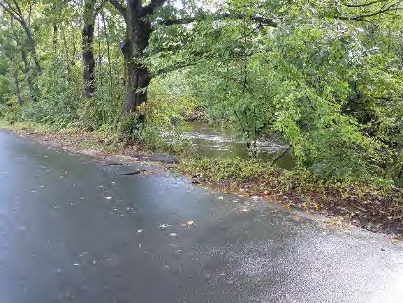
Beach Street/Bladens River
Two ponds at and upstream of the Kerite Dam are reportedly
nearly full of silt and fine sediments and have little to no
storage capacity. During large-scale rain events, when the
water level rises above the Bladens River Dam upstream of the
Kerite Dam, the water flows down Beach Street, sometimes
flowing down Pearl and Day Streets. This water overtops the
roads and some properties in the area.
Bank Street/Little River
Properties along Bank Street in the area of Wire Company
Dam #3 and Wire Company Dam #2 are reportedly subject to Area where Bladens River can flood
flooding as a result of high flows along Little River and poor roadways; note high flow of 9/8/12
drainage along Route 67. One RLP has historically been listed
at the end of the Little River, but this building has been
demolished, and the site is unoccupied.
Unnamed Watercourse at Walnut Street
A residence on Walnut Street has been repeatedly subject to
flooding during large-scale rain events. According to town
officials, Seymour has funded the replacement of a portion of
property damage; however, the storm drainage in this area is
in need of upgrading.
Unnamed Drainage Along Roosevelt Drive (Route 34)
Multiple homes are subject to flooding from hillside drainage Area where Little River can flood
during large-scale rain events in this area of town. commercial property; note high flow of
9/8/12
3.2.2 Vulnerability Analysis of Private Properties
In 2012, the software platform ArcGIS was utilized along with 2010 Microsoft Virtual Earth aerial
photography to determine the number of structures located within the various floodplains within the Town.
Seymour has 118 structures within the 100-year floodplain or floodway. According to that analysis, a total
of 2,578 acres of land were located within the 100-year flood boundary, and an additional 1,090 acres of
land were located within the 500-year flood boundary, in 2010.
According to FEMA, Seymour has zero Repetitive Loss Properties (RLP). Of those, zero are classified as
Severe RLP. According to municipal staff, Seymour has had one RLP that has been vacated and demolished.
The property was classified as commercial/ industrial use and located on River Street in a SFHA associated
with Little River. Seymour will work with CT DEEP and FEMA to verify the RLP list.
3.2.3 Vulnerability Analysis of Critical Facilities
Three critical facilities in Seymour are located within a 1% annual-chance or 0.2% annual-chance floodplain.
This includes facilities located in areas designated as X-Protected by Levee. Table 3-3 lists these critical
facilities.
NVCOG Hazard Mitigation Plan Update 3-17
August 2021Municipal Annexes: Seymour
Table 3-1: Critical Facilities Located Within or Adjacent to Floodplains
Name or Type Address Flooding Source
Police Department Franklin Street Naugatuck River
Citizens Engine No. 2 DeForest Street Naugatuck River
Regional Water Authority Wellfield Route 34 Housatonic River
Although some of these facilities are protected by the Derby and Ansonia flood control systems, the
potential exists that these critical facilities can become flooded any year.
NVCOG Hazard Mitigation Plan Update 3-18
August 2021Copyright SLR Consulting - 2021
Date Saved: 6/15/2021
"
)8
o rat St reet
ok
Sk
est S
t
W
t re
ee
Document Path: C:\Users\noahs\Documents\MMI\ArcGIS\Maps\NVCOG.mxd
S tr
ad l
et
ar
oad Pe
in Ro
Ma
R
pl e
u n ta
g ay
Str
n
Mo
ee
Bu
t
"
) 313
M oss A
Gr e
ve
ue
t
t ree
n
L o we
at H
d
rB
a
in S
Ro
u
lon y Road
o
ill R
ck
South Ma
SEYMOUR
ngay R
ntu
ad
Rim m o
Sq
ua
"
) 334 n
Ro
oa d
Co
ad
Ro
se
ve
o
lt
Dr
iv e
Critical Facilities Historic Sites
"
) Historic Sites
'
" Care Facility
Flood Zone
Communications
A
B
"
&
³
² Community Center AE
Emergency Response Floodway
H Fuel X: 0.2% Annual Chance
ñ Government Services
k School
¼
¸
Utility
1
Vulnerable Population
Flood Hazards in Seymour
99 REALTY DRIVE
CHESHIRE, CT 06410
203.271.1773
NVCOG Hazard Mitigation Plan Update
Naugatuck Valley Council of Governments
47 Leavenworth Street, 3rd Floor
Waterbury, CT 06702
0
± 2,000
Feet
4,000
DATE 6/15/2021
141.3211.00029
PROJ. NO.
FIG. 3-1Municipal Annexes: Seymour
4.0 HURRICANES AND TROPICAL STORMS
4.1 Existing Capabilities
Flooding
Existing capabilities appropriate for flooding were discussed in Section 3.0. These include the ordinances,
codes, and regulations that have been enacted to minimize flood damage. In addition, various structures
exist to protect certain areas, including dam and local flood protection projects.
Wind
Wind loading requirements are addressed through the state building code. The State Building Code has
been amended several times in the past two decades. The 2005 Code was amended in 2009, 2011, and
2013. The code was then updated and amended in 2016, with the current code having been updated and
effective as of October 1, 2018. The code specifies the design wind speed for construction in all the
Connecticut municipalities. Effective October 1, 2018 the design wind speed for Seymour is 115 mph for a
Category 1 event, 125 mph for a Category 2, and 135 mph for a Category 3, 4 or 5 hurricane event.
Connecticut is located in FEMA Zone II regarding maximum expected wind speed. The maximum expected
wind speed for a three-second gust is 160 mph. This wind speed could occur as a result of either a hurricane
or a tornado in western Connecticut and southeastern New York. The American Society of Civil Engineers
recommends that new buildings be designed to withstand this peak three-second gust.
Eversource, the local electric utility, provides tree maintenance near its power lines. The Town’s Tree Warden
performs tasks with variable responsibilities and resources as noted below:
The Public Works Director holds the position of Tree Warden in the town.
The Town has a boom truck and a chipper that is employed for tree maintenance.
Prior to severe storm events, the Town ensures that warning/notification systems and communication
equipment are working properly and prepare for the possible evacuation of impacted areas.
New Capabilities and Completed Actions
Seymour continues to maintain its strong tropical cyclone mitigation capabilities.
Summary
Seymour mitigates hurricane and tropical storm damages through tree and limb maintenance, public alert
and communications procedures, and enforcement of building code requirements related to high winds.
NVCOG Hazard Mitigation Plan Update 4-20
August 2021You can also read