Ship weather routing using pathfinding algorithms: the case of Barcelona - Palma de Mallorca - UPCommons
←
→
Page content transcription
If your browser does not render page correctly, please read the page content below
.

 Ship weather routing using pathfinding algorithms: the case of
                Barcelona – Palma de Mallorca

                                    Manel Grifoll
      Barcelona Innovation in Transport (BIT), Universitat Politècnica de Catalunya
                              (UPC·BarcelonaTech), Spain
                                   Lluís Martorell
      Barcelona Innovation in Transport (BIT), Universitat Politècnica de Catalunya
                              (UPC·BarcelonaTech), Spain
                                  Marcel·la Castells
     TRANSMAR, Universitat Politècnica de Catalunya (UPC·BarcelonaTech), Spain
                              F.Xavier Martínez de Osés
     TRANSMAR, Universitat Politècnica de Catalunya (UPC·BarcelonaTech), Spain

ABSTRACT

Weather ship routing has become a recognized measure to target safe, sustainable and
economical ship activities. Academic research has focused the ship routing optimization
through pathfinding algorithms which take into account the meteo-oceanographic forecasts
(i.e. wind, waves or currents predictions). This contribution shows the results of the
numerical simulations carried out during the development of a weather ship routing applied
to a ferry service in the Mediterranean Sea: Barcelona – Palma de Mallorca. From a
methodological point of view, the pathfinding A* algorithm is applied to optimize the travel
time considering the wave action. Under severe weather conditions, a reduction of the 6%
of the travel time is obtained comparing the optimized route and the minimum distance route.
The results show also a non-significant correlation between the travel time reduction and
wave height. In consequence the benefit of ship routing depends not only of the wave height
but also in the spatial sequence of the storm.

1. INTRODUCTION

   A major factor of competitiveness in the maritime industry is the minimization of fuel
consumption for ship routes. This agrees with an increase of the world tendency to reduce
air emissions in the framework to mitigate the climate change effects. From the shipping
industry point of view this may be achieved with an optimum route plan design (Simonsen
et al., 2015). The ship routing is defined as the development of an optimum sailing course
and speed for ocean voyages based on nautical charts, forecasted sea conditions, captains’
experiences and the individual characteristics of a ship for a particular route. Academic
research has focused the ship routing optimization through pathfinding algorithms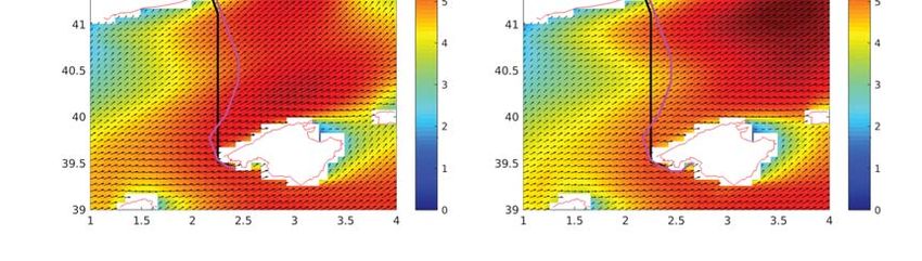
.

(Takashima et al., 2009; Mannarini et al., 2013; Szłapczyńska and Śmierzchalsk, 2009;
Larsson and Simonsen, 2014 and Hinnenthal and Günther, 2010) which take into account
the meteo-oceanographic forecasts (i.e. wind, waves or currents predictions). Some of these
contributions have been tested through a “proof-of-concept” based in oceanic distances
(Simonsen et al., 2015). However, at short-distances (for instance in the framework of the
Short-Sea Shipping or Ferries activities) the weather ship routing implementation and benefit
is not yet fully investigated (Grifoll et al., 2018). In this case, historically the spatial
resolution of the meteo-oceanographic predictions (grid resolution of the numerical model)
is a severe restriction to design feasible ship routing.
        The benefits expected of the best possible route is associated in terms of criteria like
estimated time of arrival (ETA), fuel consumption, emission minimization, safety (i.e.
parametric rolling or surfriding) and comfort (passengers seasickness). The objective of this
contribution is to show the numerical test carried out during the development of a weather
ship routing applied to a short distance. From a methodological point of view, the work
presented in this contribution prove the suitability of the implementation of a pathfinding
algorithm (i.e. A*) for the optimum ship routing in a relative short maritime distance:
Barcelona – Palma de Mallorca. The ship route comparison (minimum distance versus
optimal route) shown in this contribution evidences the benefit in terms of travel time. As a
consequence, the percentage of services, which the travel reduction is significant, is assessed
using wave predictions.

2. METHODOLOGHY

The pathfinding algorithm used in this contribution is the A* (Dechter and Pearl, 1985). This
algorithm is applied at gridded scheme where each gridpoint (node) is connected to a set of
vicinity points. To each connection (edge) a weight related with the distance is assigned. The
great circle (orthodromic) track distance is used for the spherical coordinates of grid nodes.
A* solves routing problems by searching among all possible paths to the solution (goal) for
the one that incurs the smallest cost (least distance traveled, shortest time, etc.), and among
these paths it first considers the ones that appear to lead most quickly to the solution. A* is
formulated in terms of weighted mesh: starting from a specific node of the mesh, it constructs
a tree of paths starting from that node, expanding paths one step at a time, until one of its
paths ends at the predetermined goal node. At each iteration of its main loop, A* algorithm
needs to determine which of its partial paths to expand into one or more longer paths. It does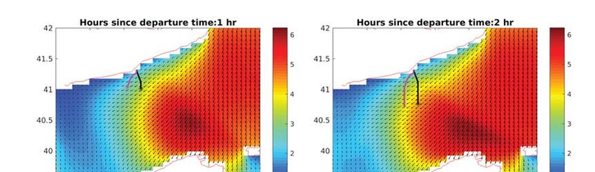
.

so based on an estimate of the cost (in our case the travel time) to go to the goal node. In
particular, A* selects the path that minimizes the total cost function F(n):

                                  F(n)=G(n)+H(n)                          (1)

where n is the last node on the path, G(n) is the cost of the path from the start node to n, and
H(n) is a heuristic that estimates the cost of the cheapest path from n to the goal. For the
algorithm, to find the actual shortest path, the heuristic function must be admissible, meaning
that it never overestimates the actual cost to get to the nearest goal node. In our case, the
heuristic function is the minimum distance between origin and destination. The description
of the operating principle of the code (pseudocode) is shown in Grifoll and Martínez de Osés
(2016).
   Wave action is the major factor that affects the ship motions, decreasing the propeller
thrust and adding a resistance in comparison to absence of waves. A simple formula to
include ship speed reduction into waves is suggested by Bowditch (2002). The final speed
is computed in function of the non-wave affected speed plus a reduction in function of the
wave parameters:
                                  v = v0 − f (θ) · HS2             (2)
Where HS is the significant wave height and f is parameter in function of the relative ship
wave direction (θ; see Table 1). The wave predictions used are provided by the operational
systems distributed by the Puertos del Estado (see more information of the forecasting
system in Grifoll et al, 2018).

  Ship wave relative direction         Wave direction                 f(kn/ft2)
              (θ)
 0° ≤ Θ ≤ 45°                          Following seas                  0.0083
 45° < Θ < 135°                          Beam seas                     0.0165
 135° ≤ Θ ≤ 225°                          Head seas                    0.0248
 225° < Θ < 270º                          Bean seas                    0.0165
 270° ≤ Θ ≤ 360°                       Following seas                  0.0083
Table 1 – Values of the coefficient f in function of the ship wave relative direction (θ).

3. RESULTS

This section presents the numerical results obtained using the previous methodology applied
at the Barcelona – Palma de Mallorca route (Mediterranean Sea). The horizontal grid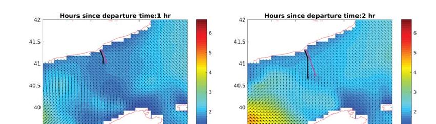
.
resolution has been 1.5 minutes with a connection of 24 edges per each node. An initial
cruise ship speed of 20 knots has been considered and 25 wave energetic scenarios occurred
between December 2016 and March 2017 has been selected. In order to characterize the
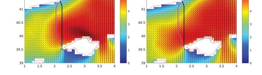
typical wave climate, Figure 1 and 2 show the temporal evolution of two energetic episodes
in terms of significant wave height: Figure 1 shows a Northeastern storm and Figure 2
Southwestern storm. The color bar represents the value of HS and black arrows the direction
of propagation of the waves. During these energetic episodes the ship routing recovered by
the A* algorithm is shown (in magenta) for each snapshot. Alternatively the minimum
distance is also shown in black. In both cases, the optimal route tends to avoid the most
energetic areas from a wave conditions point of view. For instance, Figure 2 shows how
during Southwestern storm the optimal route is displaced towards north in comparison to the
minimum distance route. In this case the travel time for the optimal route is 8.1 hr, lower
than the time traveled by the minimum distance route (i.e. 8.4 hr). In order to generalize the
ship routing pattern, Table 2 summarizes the ship routing results considering the mentioned
25 energetic scenarios. The departure time has been selected based on the current services
in the vessel routes between Barcelona and Palma de Mallorca. Differences around tens of
minutes are obtained in function of the significant wave height. The maximum difference
(0.55 hr) were obtained during the ship route starting at 17/01/2017 00:00, which
corresponds a significant wave height of 4.5 m.
Time of max(HS) Duration for Duration for Difference Distance of
departure (in m) the optimized the (in hr) the
(dd/mm/yyyy route (in hr) minimum optimized
hh:mm) distance Route (in
route (in hr) nautical
miles)
19/12/2016 3.2
00:00 7.0 7.0 0.0 0.000
19/12/2016 3.7
05:00 7.1 7.1 0.0 0.001
20/12/2016 5.0
06:00 8.3 8.8 0.5 5.567
20/12/2016 4.3
10:00 7.8 8.2 0.4 3.033
21/12/2016 3.4
00:00 7.2 7.3 0.1 0.867
21/12/2016 3.7 7.3 7.4 0.1 0.870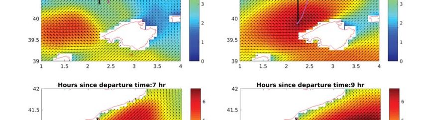
.

     05:00
  09/01/2017         3.0
     00:00                        6.9            7.1          0.2         0.871
  09/01/2017         3.3
     03:00                        7.1            7.2          0.1         1.155
  11/01/2017         4.0
     00:00                        7.2            7.4          0.2         1.438
  11/01/2017         4.3
     02:00                        7.4            7.7          0.3         2.685
  13/01/2017         1.9
     00:00                        6.8            6.8          0.0         0.019
  17/01/2017         4.5
     00:00                        7.6            8.1          0.5         2.402
  18/01/2017         3.9
     00:00                        7.2            7.4          0.2         0.303
  19/01/2017         4.0
     06:00                        7.3            7.3          0.0         0.020
  20/01/2017         3.8
     00:00                        7.3            7.3          0.0         0.001
  21/01/2017         5.6
     06:00                        7.9            8.0          0.1         0.020
  21/01/2017         6.8
     11:00                        8.9            9.3          0.4         0.304
  22/01/2017         6.8
     00:00                        9.1            9.2          0.1         1.353
  22/01/2017         6.0
     03:00                        8.4            8.5          0.1         0.587
  22/01/2017         5.8
     06:00                        8.1            8.2          0.1         0.585
  05/02/2017         3.1
     00:00                        7.0            7.0          0.0         0.013
  06/02/2017         5.4
     00:00                        8.6            8.7          0.1         1.352
  04/03/2017         6.2
     00:00                        8.1            8.4          0.3         3.569
  04/03/2017         5.3
     02:00                        8.2            8.4          0.2         3.610
  04/03/2017         4.9
     04:00                        8.0            8.3          0.3         3.333
Table 2– Results of the 25 ship routing simulations obtained for Barcelona – Palma de
Mallorca in function of the time of departure. The minimum distance route is 133.292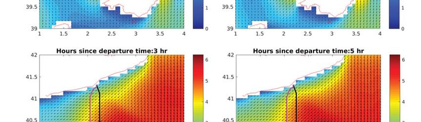
.

nautical miles.ig. 1 – Temporal sequence of the snapshot of the case Barcelona – Palma
de Mallorca. The optimal route is plotted in magenta and the minimum distance route
is plotted in black. The color bar represents the HS and the black arrows the
propagation direction of the waves. This route corresponds to a departure time of
17/01/2017 00:00 h.
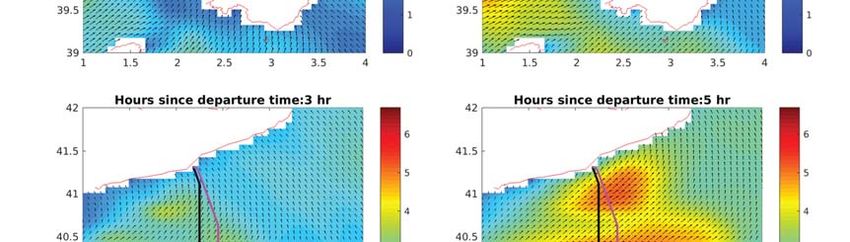
.

Fig. 2 – Temporal sequence of the snapshot of the case Barcelona – Palma de Mallorca.
The optimal route is plotted in magenta and the minimum distance route is plotted in
black. The color bar represents the HS and the black arrows the propagation direction
of the waves. This route corresponds to a departure time of 4/03/2017 00:00 h.

 The snapshot shown in the Figure 3 reveals that similar maximum HS leads differentiated
optimal ship routing after 4 hours of the departure. In this case, the difference of the wave
climate relies in the homogeneity of the storm instead of the maximum HS (more spatial
heterogeneity in the wave conditions shown in the Figure 3.left). In this sense, From a
practical point of view, it is interesting to analyze the relation between the maximum HS and
.

the increase of travel time in comparison to the time given by the minimum distance route
(Figure 4.Left). This Figure shows how there is not significant correlation between HS and
the decrease of the travel time (r=0.37; p>0.05). The non-significant correlation of the
optimal route and the wave climate is also shown in the relation between the maximum HS
and the increasing of the distance associated to the optimal route in comparison to the
minimum distance (Figure 4.Right; r=0.31; p>0.05). In consequence, the determination of
the optimal route is not only due to the HS and wave direction (as suggested in Equation 2
and Table 1), but also the spatial evolution of the storm may have a relevant role on the
determination of the optimal route.

Fig. 3 – Left: maximum HS and the increase of travel time versus the time given by the
minimum distance route in the 25 scenarios investigated. Right: maximum HS versus
the increasing of the distance associated to the optimal route in comparison to the
minimum distance in the 25 scenarios investigated.
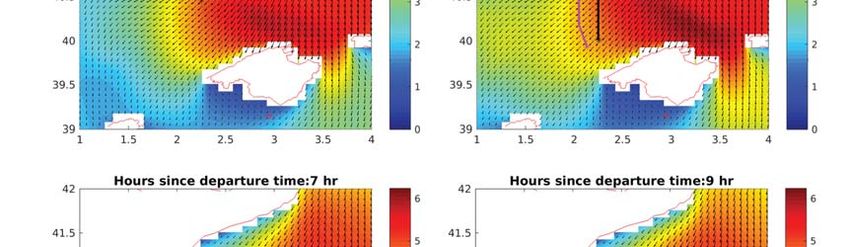
.

Fig. 4 – Left: Snapshot of the case Barcelona – Palma de Mallorca after 9 hours of
departure for a departure time of 20/12/2016 at 06:00 h. Right: Snapshot of the case
Barcelona – Palma de Mallorca after 7 hours of departure for a departure time of
22/01/2017 at 03:00 h. The optimal route is plotted in magenta and the minimum
distance route is plotted in black. The color bar represents the HS and the black arrows
the propagation direction of the waves.

4. FINAL REMARKS

The ship route comparison (minimum distance versus optimal route) evidences the relevance
of the wave effects on navigation. Even the short distance between Barcelona and Palma the
reduction in terms on time sailed using ship routing may be substantial (7% of the total time).
The analysis of the 25 episodes revealed a non-significant correlation between the travel
time reduction and the maximum wave height occurred during the navigation route. In
consequence, the benefit of ship routing would depends not only of the maximum wave
height but also other wave parameters (such as wave direction) and the the spatial sequence
of the storm.

This sailing time reduction may lead to substantial economic benefit. In this sense, Grifoll
et al. (2018) quantify the economic benefit of using the ship routing methodology shown in
this contribution for a Short-Sea Shipping activity (among Spanish and Italian ports). In this
case, the percentage of economic cost savings may reach 18% of the total costs under severe
storms considering bunkering, crew costs among other factors. This economic benefit of ship
routing systems at ferry services distances justifies the use of these systems in the inclusion
of competitiveness analysis of inter-modal routes in decision-making strategies (for instance
Martínez-López et al. (2015)) or such a complementary information to other optimization
techniques such as fleets management (Fagerholt, 2006) or scheduling orientation (Cho and
Perakis, 2010). In our contribution, the ship weather routing implementation is accompanied
with the developing of high-resolution meteo-oceanographic products (such as the products
.

provided by Puertos del Estado). In this sense, further works include the consideration of
water currents and wind effects on navigation. Also, further research in the methodology
includes the implementation of the method for dynamic wave states, the implementation of
the multi-criteria algorithm or the methodological inclusion of safety restrictions due to the
wave conditions (parametric rolling and broaching/surf-riding).

REFERENCES

BOWDITCH, N. (2002) The American practical navigator. National Imagery and Mapping
Agency, Bethesda, Maryland, USA.

CHO, S.C. and PERAKIS, A.N. (2010). An improved formulation for bulk cargo ship
scheduling with a single loading port. Maritime Policy and Management, No. 23, Iss. 3: 249-
259.

DECHTER, R. and PEARL, J. (1985) Generalized best-first search strategies and the
optimality of A*. Journal of the ACM, Vol. 32, Issue 3, 505–536.

FAGERHOLT, K. (2006) Designing optimal routes in a liner shipping problem. Maritime
Policy & Management, Vol. 31, Iss. 4: 259-268.

GRIFOLL, M, MARTÍNEZ DE OSÉS, F.X. and CASTELLS, M. Potential economic
benefits of using a weather ship routing system at Short Sea Shipping. (2018). WMU Journal
of Maritime Affairs. Accepted on 22 March 2018.

GRIFOLL, M., and MARTÍNEZ DE OSÉS, F. X. (2016) A ship routing system applied at
short sea distances. Journal of Maritime Research, 13(2), 3-6.

HINNENTHAL, J. and GÜNTHER, C. (2010). Robust Pareto optimum routing of ships
utilizing deterministic and ensemble weather forecasts. Ships And Offshore Structures Vol.
5, Iss. 2: 105-114.

LARSSON, E., and SIMONSEN, M. H. (2014) DIRECT weather routing. Master’s thesis,
Chalmers University of Technology, Sweden.

MANNARINI, G., COPPINI, G., ODDO, P. and PINARDI, N. (2013). A Prototype of Ship
Routing Decision Support System for an Operational Oceanographic Service. TransNav, the
International Journal on Marine Navigation and Safety of Sea Transportation, Vol. 7, No.
1: 53-59.

MARTÍNEZ-LÓPEZ, A., MUNÍN-DOCE, A. and GARCÍA-ALONSO, L. (2015). A multi-
criteria decision method for the analysis of the Motorways of the Sea: the application to the
case of France and Spain on the Atlantic Coast. Maritime Policy & Management, Vol. 42,
Iss. 6: 608-631.

SIMONSEN, M. H., LARSSON, E., MAO, W. and RINGSBERG J. W. (2015). State-of-art
.

within ship routing. Proceedings ASME, 34th International Conference on Ocean, Offshore
and Arctic Engineering. Volume 3: Structures, Safety and Reliability. Canada.

SZLAPCZYNSKA, J. and ŚMIERZCHALSKI, R. (2009). Multicriteria Optimisation in
Weather Routing. TransNav, the International Journal on Marine Navigation and Safety of
Sea Transportation, Vol. 3, No. 4: 393-400.

TAKASHIMA, K., MEZAOUI, B., and SHOJI, R. (2009). On the Fuel Saving Operation
for Coastal Merchant Ships using Weather Routing. TransNav, the International Journal on
Marine Navigation and Safety of Sea Transportation, Vol. 3, No. 4: 401-406.
You can also read