SHORT NOTICES & ANNOUNCEMENTS
←
→
Page content transcription
If your browser does not render page correctly, please read the page content below
SHORT NOTICES & ANNOUNCEMENTS

The Panopticon
Google Earth, Omnipotence and Earthly Delights
By Asa Simon Mittman, California State University at Chico

Floating in Dark Sea
        The sky is a flat black, dotted with stars that stand out as single white pixels. It is an
inanimate, undifferentiated surface, without depth, without life. Then out of the darkness looms
a bright marble, a growing sphere: planet earth, or rather, Google Earth, an entity bearing only
fragmentary similarity to our world. In comparison with the dull field behind it, the globe is
stunning, riveting, arresting. With the slightest pressure of the index finger, and the smallest
flick of the wrist, we set the world spinning—along the conventional polar axis if we so wish,
but along any other, if we prefer. The earth we see is at once individual and multiple, self-
evidently an integral unit and simultaneously composed of a multitude of individual images.
Hundreds? Thousands.

        Another                                                                      click, another
flick, and we                                                                        soar inward
toward earth,                                                                        more in than
down. The                                                                            sensation is far
less of alarm of                                                                     falling than of
the excitement                                                                       of approaching,
or better, of                                                                        pulling the
earth toward                                                                         us. How far in
can we go, how                                                                       close to our
home? There                                                                          is an inevitable
tension, as we                                                                       doubt that we
will be able to                                                                      truly penetrate
the                                                                                  atmosphere, to
transcend                                                                            global,
continental, or                                                                      even national
contexts to arrive at the deeply local—our city, our neighborhood, our street, our block, our
house. The prospect of instantaneous access to detailed satellite photography of a location is no
longer a technical marvel. We expect this, when looking up directions to a friend’s house for a
dinner party, wishing no longer merely to know in advance where her house is, but what it looks
like, and if the street looks like the sort of place likely to have ample parking. But the experience
of operating Google Earth is different, owing to both the fluidity of motion and the presence, at

                                                                                                     1
all times, of the totality of the earth, regardless of the depth of focus. We can, in an instant,
without reloading a page, launch outward, returning to the position of an omniscient deity.
Earthly Delights
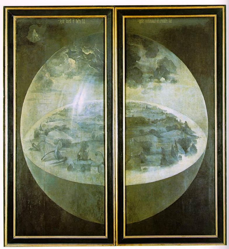
Among the more familiar, if puzzling, images of the Northern Renaissance is the Garden
of Earthly Delights, by the imaginative master, Hieronymous Bosch. The center panel of this
triptych is the most well-known and frequently reproduced portion, showing a riveting series of
gambols, many sexual in implication and several involving unusual partners: giant birds, berries
Exterior wings of Hieronymous Bosch, Garden of Earthly Delights, Prado Museum.
and bivalves. But if we close the wings of the triptych—hiding the glorious, if ultimately
condemnatory, Garden—we are confronted by a radically different tone. The image presents the
Third Day of Creation. Planet Earth looms out of a blackness which recalls that of Google Earth.
Here, though, the globe is painted in grisaille and so seems, unlike the Technicolor image of
Google Earth, cold, dead, and utterly still. The landscape is visible in surprising detail, as if we
are at once seeing the whole and have also zoomed in to great depth, so we can see the entire orb
of the earth, and at the same time individual plants and rocks, emerging as the waters recede. It
is as if the planet might be traversed in half a day’s sturdy walking. Still, storm clouds seem
2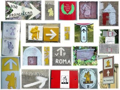
gather ominously overhead, as if suggesting impending cataclysm, though these are only the
remnants of the separation of the light and the darkness.
        To the upper left, we see the Creator. He is, like the world he has made, without color
and without animation, as if frozen in the vast emptiness of space. He seems to be buoyed up on
a cloud, though clearly the clouds of earth are contained within its shining, glassy atmospheric
dome. The vantage point afforded by Bosch to the supreme deity is the very viewpoint presented
by Google Earth as we hover, held aloft by an unseen force, as far above or as close to the
surface of the planet as we wish.
        While this is a moment of creation, in which God begins to fill the world with life, he
nonetheless seems so distant and remote from his “great and wearisome effort,” as if already
sensing the disgust he will (in the mind of Bosch) eventually feel toward the world and its
inhabitants.1 He also seems, in comparison to the user of Google Earth, impotent. As Peter
Beagle writes, “God seems very small and far away, already retreating from the consequences of
his world.”2 What, then, is our position in regard to the world, when we view it through the
interface of Google Earth, rather than through the interface of “real” life? I would argue that it is
one of power, certainly, and also of pleasure, of earthly delight.

Power
        The God of the Torah is omniscient, and so he is defined by his ability to see all of the
world. Just so, with Google Earth open before us on our monitors, we can spy on any corner of
the world we wish. We do this with the tremendous power of the unfettered gaze. Looking in
from above, from the position of the Creator, we can gaze without any concern that we might, in
turn be seen. There are two reasons for this. First, we are presumably high in the sky. We are
given the vantage point of the gargoyles: “Because they are almost always above human
sightlines, and because people … rarely look up, they don’t see…them … but they see us.”3
Second, and more important, despite the great sense of presence of the luminous image before
us, we are not there, and the photographs do not show the current moment. Even if we are to call
up the very address at which we sit, and haul our laptops out into the street, despite a strong
wireless signal we will of course not see ourselves standing there, in the dizzying vertigo of
mise-en-abyme—at least not yet. These are still photographs, taken at specified moments in the
recent past (the Digital Global Coverage option displays the quadrants covered by each
individual photograph, and provides the exact date of every one, all of which were taken in the
last few years). Still, it is hard to imagine that we will not be granted the greater power of the
immediate and contemporary gaze at some time in the near future, merging the voyeuristic
effects of the Webcam with the panoptical gaze of Google Earth.

Utility and Longing
        What is Google Earth? Ostensibly, it is the most sophisticated mapping system available
to the “average” person, far more elegant than any GPS device and leaving the now pedestrian
browser-based systems of Mapquest and the like far behind, never mind those increasingly
1
    Peter S. Beagle, The Garden of Earthly Delights (New York: Viking, 1982), 38.
2
    Beagle, 39.
3
 Stephen King, Nightmares in the Sky: Gargoyles and Grotesques (New York: Viking Studio Books, 1988), 9,
quoting Marc Glimcher.

                                                                                                           3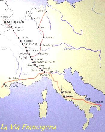
antiquated printed maps on which we used to rely. But those foldout (never-to-be-properly-
folded-back-in) maps in our glove compartments are, in many ways, far more useful, in that they
very simply, with a minimum of fuss, help us to travel from one location to another. The
interface of Google Earth, in sharp contrast, is elegant and stunning, so much so that its potential
utility as a navigational device (as it was, in part, intended) breaks down as we are, instead,
reduced and elevated to the state of wonder. Google Earth lists four bulleted functions that “put
the world’s geographic information at your fingertips”:

• Fly to your house. Just type in an address, press Search, and you’ll zoom right in.
•Search for schools, parks, restaurants, and hotels. Get driving directions.
•Tilt and rotate the view to see 3D terrain and buildings.
•Save and share your searches and favorites.4

In this grand list, “get driving directions” seems rather an afterthought, far secondary to the
jouissance inspired by the interface.
         If we cannot or would not use Google Earth to learn how to get from Point A to Point B,
at least not in any literal sense, then for what can we use it? For analogues, we might turn to the
walls of our elementary schools, where we invariably find world maps displaying the whole
globe, though flattened out as if under a microscope slide, seemingly etherized and pinned like a
prize gall wasp. In contrast, the world presented by Google Earth is a whirl of dynamism and
motion, of infinite potential. If we showed our children Google Earth instead of the woefully
out-of-date and ignorantly misused Mercator Projection Map, they might learn a great deal more
about how the world is arranged, and we would no doubt find not only the computer science
departments, but also the geography and cartography departments of our universities to gain
healthy enrollments.
         Regardless of their effectiveness or appropriateness—the use of a sixteenth-century naval
navigation device for the education of the children of the twenty-first century is dubious, at
best—the function of large wall-mounted Mercator world maps is clearly not navigational.
These maps have been hung to help in the education of our children. They are not designed to
help students in Lawrence, Kansas, the slightly contentious “center” of Google Earth, to get to
Easter Island, though it might stir in them longings to eventually find their way hence. But if
the maps on classroom walls entice, they do so through their lack of specificity, through their
strategic creation of tension between details and the lack thereof. Exotic names that conjure—or
better still, are too wholly unfamiliar to conjure—images of a world far removed from our
surroundings are paired with featureless expanses of color. As Marlow, the narrator of Conrad’s
Heart of Darkness, describes the maps of his childhood:
         At that time there were many blank spaces on the earth, and when I saw one that looked
particularly inviting on a map (but they all look that) I would put my finger on it and say, “When
I grow up I will go there.” The North Pole was one of these places, I remember. Well, I haven’t
been there yet, and shall not try now. The glamour’s off. Other places were scattered about the
hemispheres. I have been in some of them, and . . . well, we won’t talk about that. But there was
one yet—the biggest, the most blank, so to speak—that I had a hankering after.5

4
    “Explore, Search and Discover,” Google Earth (Google, 2007)  (accessed 2/7/2007).
5
    Joseph Conrad, Heart of Darkness (Signet Classics reprint: New American Library 1902), 70-71.

                                                                                                                  4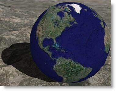
This is a passage redolent with what Sylvia Tomasch has called “geographical desire,”6
with the raw and urgent craving not merely for travel—this is no mere itchy-footed wanderlust—
but to know the world, to gain a greater understanding of the lacunae on our maps. This
optimistic enterprise takes as its underlying and unvoiced assumption that once the world is fully
mapped, fully named, fully known, it will become at last intelligible to us, not merely a
frightening and overwhelming jumble of places, imperfectly linked. This desire is, at its root,
utopian.
        Of course, Marlow’s voyage into the dark heart of Africa provides no such resolution.
Rather, it compounds our fears and doubts, so that the region, “had ceased to be a blank space of
delightful mystery—a white patch for a boy to dream gloriously over. It had become a place of
darkness.”7 The journey marks it as permanently unknowable and worse, destroys our desire to
ever return, to plot out the Congo once and for all.
        But with Google Earth, all is mapped, and from the safe distance of the satellite, floating
438 miles over the surface of the earth and gazing down upon it with the same cold and detached
eye of Bosch’s God.8 We may, indeed, look upon the Congo if we wish, following it through
every winding turn and cataract, though without the fear of ever becoming ensnared in the
psychological web of Kurtz. As observed by the manager’s servant, “he dead,” and with him,
the fears that were once part and parcel of scopic engagement with the most distant of lands.9

Google Earths
        The image presented by Google Earth shows us not one, by many earths. In her riveting
Troll, Johanna Sinisalo describes the same city, as seem from the perspectives of people of
drastically different social groups:

Odd how there can be cities and cities. Cities within cities … There’s the city of a certain kind
of woman, who judges a street by the kinds of shops there are, the classiness of the fashion
shops, the perfumeries, jewelers, shoe stores. An alcoholic’s city, on the other hand, consists of
pubs, sausage stands, liquor stalls, alleys where you can piss without being picked up for
indecent behavior … And he doesn’t even notice the designer boutique because it’s got no
function for him, just as the fashionable lady doesn’t see that sleazy dive—it doesn’t exist for
her.10

http://etext.virginia.edu/etcbin/toccer-
new2?id=ConDark.sgm&images=images/modeng&data=/texts/english/modeng/parsed&tag=public&part=1&divisio
n=div1
6
  Sylvia Tomasch, “Medieval Geographical Desire,” Text and Territory: Geographical Imagination in the
European Middle Ages, ed. Sylvia Tomasch and Sealy Gilles (Philadelphia: Pennsylvania University Press, 1998),
entire, esp. 3.
7
    Conrad, 71.
8
 The images on Google Earth come from TerraMetrics, Inc., which in turn uses the Landsat 7 satellite, which orbits
at 705 kilometers, or 438 miles. See Ed Sheffner, “Landsat 7,” Landsat Program (October 5, 1999)
 (accessed 2/6/2007)
9
    Conrad, 148.
10
     Johanna Sinisalo, Troll, trans. Hebert Lomas (New York: Grove Press, 2003), 105.

                                                                                                                 5
Sinisalo describes how the city is seen by dogs, by bus drivers, by members of a gay subculture.
Each eye sees different aspects of the world. So too, with Google Earth. We can choose not
only what region we see, but what details interest us. We might be interested, as is Sinisalo’s
“certain kind of woman” (a phrase that echoes precisely the descriptions of the geographically
obsessive Wonders of the East of the Middle Ages)11 in shops, though we cannot yet isolate the
finer variety. Likewise, we can highlight hotels, restaurants, transportation systems,
geographical features, churches, even crime statistics. At the tick of a box, we know how many
assaults and murders were recorded in Manhattan in 2000 (7952 and 129, respectively). These
sets of information are referred to as “layers,” suggesting well the presence of multiple cities,
multiple worlds, existing on top of one another, able to be navigated at will.
Centering and Orienting the World
Centering is perhaps the most contentious issue in map design. All printed maps must be
centered somewhere, and this grants to a given locale tremendous importance. If we were to turn
to the maps of the Middle Ages, we would see that they are almost invariably centered on
Jerusalem. This is because Jerusalem was literally believed to be the center of the world, but
also because of its great holiness, its centrality to the medieval Christian worldview, most clearly
suggested by the Crusades, waged routinely for two hundred years to gain access to it.
The centering of Google Earth, then, is of great interest. It is centered on the United
States, which is not surprising. Most maps center on their country of origin. However, the
precise point on which it centers is perhaps surprising. If we zoom in without panning at all, we
will find ourselves in Lawrence, Kansas, at a small house on Regency Place, where it intersects
with Windsor. This location has been marked by a user as “Center of the Earth,” engendering
some understandable animosity, including a post from Andrés Puche, of Montréal, who writes in
angry capital letters, “THAT IS THE CENTER OF UNITED STATES ON GOOGLE EARTH,
NOT THE CENTER OF THE KNOWN UNIVERSE. THAT JUST SHOWS HOW
EGOCENTRIC YOU AMERICAN PEOPLE TEND TO BE SOMETIMES.”12 This is perhaps a
fair criticism, as the official National Atlas of the United States presents us with a series of maps
demonstrating the U.S.’s centrality to global geography.13 We see “World Geographic
Expeditions from the United States,” in which the US is not only centered, but highlighted, the
only country to have any color and it is a bold one. Tendrils of exploration radiate out, to touch
every corner of the world, from Easter Island to the Cape of Good Hope and beyond. Likewise,
the images of “U.S. Exports and Imports” marks us as the center of global commerce, and the
“United States Foreign Service” map inscribes our presence on literally ever inch of every
landmass in the world but Antarctica.
While of course Mr. Puche is correct, he has overlooked another moment of
empowerment provided by Google Earth, which allows us to move beyond the conventions of
11
We read, for example, “In certain land are men…” “Then is a certain island on which men are born…” “Then
there are other women…”
12
Andrés Puche, “Center of the Earth,” post to Google Earth Community, 05/30/06.
13
United States Department of the Interior Geological Survey, The 1970 National Atlas of the United States of
America, print version 1970, online version October 2000,
(accessed June 2005).
6the National Atlas: We can re-center the map, so that it begins anywhere we choose. Our home
town, the site of our research, anywhere. We likewise can reorient the world, breaking five-
hundred years of Eurocentric convention so that, for example, our map of the world may be
centered on Jerusalem, and oriented toward the East, following medieval convention and
producing an image surprisingly similar to the great world maps of the period. If compared to
the great Hereford Map, the largest surviving medieval map, we can see the correspondences of
Jerusalem at the center, above a vertical Mediterranean, with the British Isles clearly visible to
the lower left corner, opposite the bifurcated Red Sea in the upper right. Yes, Google Earth is set
to begin centered at a given point, with a given orientation, both of which favor the US, but the
user, though His or Her power, may center the world as seems pleasing.
Naming
To name is to grant a measure of control over a people or region, as has been discussed
by Derrida, Foucault and Althusser, among others.14 To do so in a given language is to
emphasize one’s dominion there over. A measure of conquest in entailed in inscribing the
capital of the eastern archipelago of Asia with the appellation “Tokyo,” as opposed to “東京,” an
option available in Google Earth. Such matters are not purely theoretical. For example, the
“Welsh,” still bear the pejorative nomenclatorial stamp imposed upon them by the English at
least thirteen-hundred years ago (their name meaning not only “foreigner,” but also “shameless
person” and “slave” in Old English). Among the “Welsh” people, there is now a nationalist
movement to rename the country Cymru, recovering the name by which it was known in its
native language.
Flight
Our flights throughout Google Earth are so smooth, effortless and nearly instant (the
speed is adjustable, of course). One moment, we are in New York, and not merely looking at a
black dot beside which is written “New York.” Rather, we are at the corner of 5th Avenue and
West 34th Street, looking down at the Empire State Building (or up at it, if we prefer to use the
3D Buildings feature), and with a flick, can soar uptown along 5th to West 50th, where we can
count the pier buttresses of St. Patrick’s Cathedral. Seconds later, following a beautifully
sinuous and seemingly unhurried launch into the stratosphere and back, we are in Uttar Pradesh,
gazing at the formal symmetry of the gardens of the Taj Mahal, and then at the Great Wall of
China, once considered to be the only manmade structure visible from space. Now that your
house is clearly visible, this honor is rather pallid.
Perhaps it is that I am writing this, sitting in a plane halfway between O’Hare and
Phoenix, that has my mind turning toward the drastic differences between my virtual flight, and
my lived experience of actual flight. Our flight from locale to locale in Google Earth (give
yourself a nonstop flight to the other side of the world or, better yet, plot a series of destinations,
alighting momentarily in each before ascending again, like Christ into the heavens) is so very
different from out actual flights. It is smooth, swift and beautiful, as if at last living up to the
14
Jacques Derrida, Points . . . : Interviews, 1974–1994, trans. Peggy Kamuf (Stanford: Stanford University Press,
1995), 386; Michel Foucault, “The Subject and Power,” Art After Modernism: Rethinking Representation, ed. Brian
Wallis (New York: New Museum of Contemporary Art, 1984), 420. Louis Althusser, “Ideology and Ideological
State Apparatuses,” Video Culture: A Critical Investigation, ed. John Hanhardt (Layton: Visual Studies Workshop
Press, 1986), 86.
7promises of airline ads of the 50s. It is exalted and glorious, as we revel at once in our
amazement inspired by the program, of course, but by the world, as well. In comparison, our
“real” journeys are a series of humiliations, of removed shoes and three-ounce shampoos in
quart-sized clear baggies. Only in Google Earth are more stopovers a plus, enhancing our
voyage rather than detracting from it.
If the great world maps of the Middle Ages served to remind us of the plan of God (as
they saw it), and the work of Bosch emphasizes our great distance from Him (as he saw it),
Google Earth allows us to sit on his throne, if only briefly, before our freefall back to the world
around us. Can we be surprised if we experience a bit of turbulence upon reentry? I, therefore,
prefer to return to Google Earth, calling up my world, made to order, oriented and centered as I
wish, layered to my personal interests. And then, with a flick of my wrist, I set the world to spin.
__________________________________
VIA FRANCIGENA All Roads Lead to Rome
By Adelaide Trezzini (President, Association Internationale Via Francigena)
Julius Caesar opened this shortest route between the North Sea and Rome and during the Early
Middle Ages in Italy, the route followed Roman and Longobard roads. Although it was first
called Via Francigena for the first time in 876, over the centuries the Via changed its name
according to the provenance of its users: it was “Via Francigena-Francisca” in Italy and
Burgundy, “Chemin des Anglois” in the Frankish Kingdom (after the evangelisation of England
in 607) and the “Chemin Romieux,” the road to Rome. An itinerary detailing 80 stages of the VF
can be found in the oldest diary of an Anglo-Saxon pilgrim, Archbishop Sigeric the Serious of
Canterbury, who journeyed that way when returning from Rome where he received the pallium
from Pope John XV in 990.
In Italy the Via Francigena crosses the road to Santiago, which
facilitates cooperation between the two itineraries. But for the
rest of Europe, as this Vademecum, stage by stage, describes so well,
the itinerary and the pilgrimage of one man, Sigeric, as documented
in the diary where he describes the stages of his journey,
crisscrosses the many routes used by those making their way to other
centres of pilgrimage: Compostella, Rome and Jerusalem.
Depending on the time of year, the political situation and the popularity of certain saints’ shrines
along the route, travellers may have taken one of three or four crossings of the Alps and the
Apennines. The Lombards maintened and defended the road as a trading route to the north from
Rome, avoiding enemy held cities such as Florence.
Following the Muslim conquest of Jerusalem in 640, Rome became the main destination for
Christian pilgrimages until the tenth century (though it was superceded somewhat by the the
pilgrimage veneration of St. James of Compostella in Galicia). Because of this, all kinds of
travelers from popes, emperors, bankers, and merchants to highwaymen traversed the Via
8Francigena. With the proclamation of the Holy Jubilee Year in 1300, thousands of wayfarers
travelled the Via Francigena per year on their way to Rome. Ultimately, as pilgrimage to Rome
fell out of fashion in the 17th century, so too did the traffic fall off along the Via Francigena.
The VF became Cutural Route of the Council of Europe in 1994 and Major cultural Route in
2004, but its true revival as a modern pilgrim's way from Canterbury to Rome, has been possible
thanks to pocket booklets published (2000-7) by the International Via Francigena Association
(AIVF) founded by Adelaide Trezzini in 1997.
The Via Francigena is NOT and will NEVER be as EASY as the Camino of Santiago! But
pioneer-pilgrims will appreciate the special strong human and spiritual experiences to be had on
the Via Francigena. An example of a recent trip is described in this article:
9http://www.qultures.com/Articles/2007/September/canterbury140920078912.aspx
With the last Topofrancigena B (ed.2007), the AIVF is able to suggest a historical-pedestrian
VF in Italy of 924 km, of which only 15-20km of SS (A roads). Warning: there are 15 different
signposts directing one to the VF in Italy, and they are often wrong!
Since 2001 AIVF organised with cooperation of the Vatican, the registration of VF pilgrims
(over 700 pilgrims) and handing over of the Testimonium in the sacristy of St Peter's Basilica.
The european VF logo was accepted by the Council of Europe since 2001.
Get to know the Europe of yesterday to understand better the Europe of today
www.francigena-international.org info@francigena-international.org
http://www.francigena-international.org/images/geoatlas.pdf
10Flemish Confraternity of Santiago de Compostela
http://www.compostelagenootschap.be/#Engels has just published the beautiful volume
Ontmoeting met de romaanse kunst langs de wegen en zijwegen naar santiago de Compostela by
Adriaan De Roover (aka Felix A. DeRooy) which publishes a selection of the more than 60,000
images the author took of Romanesque Art on the pilgrimage road. Accompanied by scholarly,
but accessible text (in Dutch), these are some of the most beautiful images ever taken of these
sites. It also includes a large fold-out map of the sites covered. In an act of great generosity, all
335 pictures in the book can be ordered for free from typeface@scarlet.be
To order this volume (cost €20 plus postage) e-mail verkoopdienst@compostelagenootschap.be
or write to
Vlaams Genootschap van Santiago de Compostela
Varkensstraat 6
2800 Mechelen
Belgium
_____________________________________
11The Internet Archive
The Internet Archive, (a non-profit organization) is building a digital library of Internet sites and
other cultural artifacts in digital form. Like a paper library, we provide free access to researchers,
historians, scholars, and the general public. They scan entire volumes that are now in the public
domain and make them available online for free.
http://www.archive.org/index.php
Check out their holdings which include:
The three-volume Georgiana Goddard King, The Way of St. James
http://www.archive. org/details/ wayofsaintjames0 1kinguoft
Julius Baum, Romanesque Architecture in France (1912)
http://www.archive.org/details/romanesquearchit00baum
William Worringer, Form Problems of the Gothic (1920)
http://www.archive.org/details/formproblemsofth00worruoft
and much, much more. (With thanks to Syl Nilsen for the tip.)
____________________________________
Full Screen 360 Degree Virtual Panoramas
Full Screen 360 degree Virtual Panoramas is a weekly feature presented by Hans Nyberg, a
commercial photographer in Denmark. The site features immersive panoramic images also
called VR Photography. An interactive VR panorama can not be seen in a book or on a printed
image. You can only experience the feeling of being at the place and look around, on a computer.
Used to document cultural heritage, VR Photography is an excellent media which can give you a
full view of a church or an ancient temple.
http://www.panoramas.dk/
For an amazing look at Santa Maria Maggiore, see
http://www.panoramas.dk/fullscreen/fullscreen46.html
Cordoba Mosque
http://www.panoramas.dk/fullscreen/fullscreen44.html
Cologne Cathedral
http://www.panoramas.dk/fullscreen5/f51-koeln-dom.html
____________________________________
12Flickr Groups
Flickr Groups (http://flickr.com/) is an image hosting suite and online community platform.
People upload and share personal photographs, which number over 3 billion images. Flickr asks
photo submitters to organize images using tags (a form of metadata) that allows searchers to find
images based on keywords. What makes it useful for the readers of Peregrinations are the
specialized interest groups that focus on different areas of medieval art and architecture. See, for
example,
Manuscripta Mediaevalia http://www.flickr.com/groups/678065@N22/pool/
Wall Paintings Oxfordshire
http://www.flickr.com/photos/oxfordshire_church_photos/414432852/
Oxfordshire Churches
http://www.flickr.com/groups/oxfordshirechurches/discuss/72157594528304575/
Notre Dame Architecture Library
http://www.flickr.com/people/ndalls/
Middle Ages in Europe
http://www.flickr.com/groups/middle_age_in_europe/discuss/72157605648427391/#comment72
157606050598719
God creates the heavens at Freiburg, Muenster. Photo: Varvara Slonik
http://www.flickr.com/photos/7944067@N02/633118071/
13You can also read