SINGLE DWELLING APPLICATION KIT - BUILDING IN BUSH FIRE PRONE AREAS - NSW Rural Fire Service
←
→
Page content transcription
If your browser does not render page correctly, please read the page content below

BUILDING IN BUSH FIRE PRONE AREAS

SINGLE DWELLING
APPLICATION KIT
Foreword
         This kit provides applicants with a streamlined approach
         to meeting the requirements of "Planning for Bush Fire
         Protection 2019 (PBP 2019)". It has been developed to
         assist applicants in providing information in support of
         a development application so that compliance with PBP
         can be assessed and documented as appropriate.
         This kit takes you through each step in the bush fire
         assessment process and explains how to complete
         the Bush Fire Assessment Report (BFAR) which will
         need to accompany your Development Application
         (DA). This document is intended for use only where the
         proposed development are on existing land having a
         dwelling entitlement and where no new infrastructure
         for example roads and hydrant systems are required.
         Where the intention is to increase the residential density                PLANNING FOR
         of a site like dual occupancies, multiple dwellings,                      BUSH FIRE PROTECTION
         boarding homes, workers cottages and any other                            A guide for councils, planners,
                                                                                   fire authorities and developers
         similar proposals, a bush fire assessment report may                      NOVEMBER 2019

         be required for existing development. Furthermore, it
         is intended for use only where the bush fire assessment
         is straightforward from a vegetation classification and
         slope calculations being considered. For other situations,
         the services of a suitably qualified bush fire consultant           Fig 1. RFS publication Planning for Bush Fire Protection 2019.
         should be obtained.

This kit will assist people building a new house or altering or adding to an existing building on bush fire prone land. Not all
councils will accept the single dwelling application kit so check with your local council before proceeding. If the requirements
in this kit cannot be met then a performance based solution may be needed and a suitably qualified bush fire consultant may
be able to assist.

         © Copyright 2019 held by the NSW Rural Fire Service. Apart from
         any use permitted under the Copyright Act 1968, no part may be
         reproduced by any process without prior written permission from
         the NSW Rural Fire Service.

         Disclaimer:
         Any representation, statement opinion, or advice expressed or
         implied in this publication is made in good faith on the basis that the
         State of New South Wales, the NSW Rural Fire Service, its agents
         and employees are not liable (whether by reason of negligence,
         lack of care or otherwise) to any person for any damage or loss
         whatsoever which has occurred or may occur in relation to that
         person taking or not taking (as the case may be) action in respect of
         any representation, statement or advice referred to above.

         Prepared by NSW Rural Fire Service – April 2020
         Revised version April 2020
         2   NSW RURAL FIRE SERVICE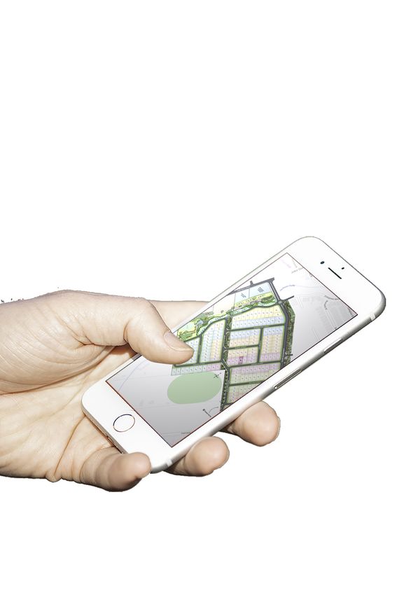
Contents
         SECTION 1                                                                                                                                                                                        4

Who should use this Kit ................................................................................................................................................................... 4
Legislative context and submission
requirements ........................................................................................................................................................................................ 4
Determining if your property is on
bush fire prone land?.......................................................................................................................................................................... 4
How to use this kit ............................................................................................................................................................................. 4
Design Principles for Building on Bush Fire
Prone Land............................................................................................................................................................................................. 4
PART A ................................................................................................................................................................................................... 5
       Property Details . ......................................................................................................................................................................... 5
PART B . .................................................................................................................................................................................................. 5
       Type of Proposal ......................................................................................................................................................................... 5
PART C ................................................................................................................................................................................................... 5
       Determining Construction Levels Required
       (Bush Fire Attack Levels, or BAL) ........................................................................................................................................ 5
Classification of Vegetation Formations Chart........................................................................................................................ 6
NSW Local Government Areas Fire Danger Index ................................................................................................................ 9
PART D ................................................................................................................................................................................................... 14
       Flame Zone ................................................................................................................................................................................... 14
PART E .................................................................................................................................................................................................... 14
       Water Supplies ............................................................................................................................................................................. 14
       Water Requirements:.................................................................................................................................................................. 14
PART F..................................................................................................................................................................................................... 16
       Gas Supplies ................................................................................................................................................................................. 16
PART G ................................................................................................................................................................................................... 16
       Access ............................................................................................................................................................................................. 16
PART H ................................................................................................................................................................................................... 17
       Asset Protection Zones ............................................................................................................................................................ 17
Dictionary .............................................................................................................................................................................................. 18

         SECTION 2                                                                                                                                                                                       19

Bush Fire Assessment Report ...................................................................................................................................................... 19
PART A: Property details ................................................................................................................................................................. 19
PART B: Type of proposal ............................................................................................................................................................... 19
PART C: Bush fire attack and level of
        construction ...................................................................................................................................................................... 20
PART D: Flame zone .......................................................................................................................................................................... 23
PART E: Water supplies ................................................................................................................................................................... 23
PART F: Gas supplies ........................................................................................................................................................................ 24
Part G: Access....................................................................................................................................................................................... 24

                                                                                                                                      SINGLE DWELLING APPLICATION KIT                                            3
Section 1
Who should use this Kit                                       a statement assessing the likely environmental
                                                              impact of any proposed bush fire protection
This kit is intended to be used to provide the
                                                              measures (BPMs) and associated works;
relevant consent authority with the information
needed so that they can assess your proposed                  a site plan showing access, water supplies, asset
development in accordance with the EP&A Act                   protection zone (APZ) requirements, bush fire
section 4.14.                                                 attack level (BAL) and building footprints in
                                                              relation to the bush fire hazards.
This kit will assist people building a new house or
altering or adding to an existing building on bush
                                                           Determining if your property is on
fire prone land. Not all councils will accept the single
dwelling application kit so check with your local          bush fire prone land?
council before proceeding. If the requirements in          To determine if your proposed development is on
this kit cannot be met then a performance based            bush fire prone land you will need to check with
solution may be needed and a suitably qualified            your local council or use the BFPL Tool on the NSW
bush fire consultant may be able to assist.                RFS website www.rfs.nsw.gov.au.
                                                           Planning law in NSW requires new development on
Legislative context and                                    bush fire prone land to comply with the provisions
submission requirements                                    of PBP 2019.
The NSW Rural Fire Service (NSW RFS) has, under
the Rural Fires Act 1997, a statutory obligation to        How to use this Kit
protect life, property and the environment through         The Kit will take you through each step in the bush
fire suppression and fire prevention.                      fire assessment process and help you describe
In response to devastating losses in past bush fires,      the site characteristics required to complete this
the NSW Government enacted legislative changes             assessment. The assessment will give you the BAL
to ensure bush fire matters are considered in the          for your property and will guide you in determining
development process.                                       the appropriate BPMs that are required for your
                                                           proposed development.
Section 4.14 of the Environmental Planning and
Assessment Act 1979 which all new development on           To complete the pull-out BFAR (Section 2) you
bush fire prone land to comply with PBP 2019.              should work through the bush fire assessment.

This kit is intended to provide you with a method          Details regarding what construction materials and
for assessing compliance with PBP 2019 for new             designs are required for each BAL are contained
building and for alterations and additions to existing     within AS3959-2018 ‘Construction of buildings in
buildings.                                                 bushfire-prone areas’ (AS3959-2018).

Development Applications (DA) on bush fire                 Further information on bush fire protection
prone land must be accompanied by a Bush Fire              requirements can be found in PBP 2019 which is
Assessment Report (BFAR) which explains how                available on the NSW RFS website.
compliance with PBP 2019 is to be achieved.
                                                           Design Principles for Building on Bush
The BFAR which is contained in the pullout section         Fire Prone Land
of this kit must address the following:
                                                           The design of a building can be enhanced to reduce
    a statement that the site is on bush fire prone        the effects of bush fire attack by:
    land (BFPL);                                              providing ember protection and building away
    the location, extent and vegetation formation of          from the flame zone;
    any bushland on or within 140 metres of the site;         avoiding building on ridge tops and saddles;
    the slope under the vegetation hazard for each            building on level ground wherever possible;
    aspect using the steepest slope within 100                building on cut-in benches rather than elevated
    metres of the site;                                       areas;
    any features on or adjoining the site that                avoiding raised floors, utilise concrete slabs;
    may mitigate the impact of a bush fire on the
                                                              locating habitable buildings near the property
    proposed development;                                     entrance for easier access/egress;

4   NSW RURAL FIRE SERVICE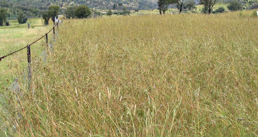
using non-combustible fencing and barriers (e.g.      Part C
   courtyards, fenced off areas for gardens, BBQ
   areas and the like) to shield the building from the   Determining Construction Levels
   hazard;
                                                         Required (Bush Fire Attack Levels, or
   reducing the bulk of a building (height and
                                                         BAL)
   width) facing a bush fire hazard; and
   simplifying the design of buildings to reduce the     To determine the BAL for a building the following
   numbers of re-entrant corners.                        steps must be followed:
                                                         STEP 1: Determine the vegetation type
Part A                                                   STEP 2: Determine the distance from the building
Property Details                                                 to the bush fire vegetation hazard

In Section 2 (A), fill in the property details for the   STEP 3: Determine the effective slope
site or buildings you plan to develop.                   STEP 4: Determine FFDI
It is important to accurately identify your property     STEP 5: Determine BAL Level
to be developed. Your Statement of Environmental
Effects which is generally included as a council         STEP 6: Determine BAL construction requirements
requirement with your DA will often include a map        If grasslands are the only vegetation bush fire
showing the property location within the broader         hazard then you can use the grassland deeming
locality. If this is not done you should include it in   provisions instead of the above assessment process.
this report.                                             If you choose to use the grassland deeming
Your contact details will assist council to quickly      provisions refer to Step 5 below.
obtain additional information or to arrange a site
inspection if needed.                                    Explanation of steps

It is important to clearly identify whether your         Step 1: D
                                                                  etermine the vegetation type
property is on BFPL. Tick the box to indicate            You will need to determine the vegetation around your
that the property has been checked against the           property to at least 140 metres in all directions from
Council’s Bush Fire Prone Land Map or the NSW            the proposed building.
RFS BFPL Tool.
                                                         Check the chart at page 6 of this document to help
                                                         determine your vegetation type.
Part B                                                   For each compass direction (normally north, south,
Type of Proposal                                         east and west) surrounding your home, identify on
                                                         the assessment sheet, using the table provided on
In Section 2 (B), tick the applicable boxes for the      the inside rear fold-out cover, what vegetation type
type of proposal.                                        your building is exposed to.
Provide a brief written description of the type of       If you are unsure of the vegetation classification,
building (i.e. single or two storeys) and what you are   you may wish to enlist the assistance of suitably
proposing to do. With alterations and additions, list    qualified bush fire consultant for advice.
the proposed works.
Attach a copy of the plans for the building you are      NOTE: Where there is more than one vegetation
proposing to build or the modifications you are          type each type shall be classified separately
making. Include a copy of any plans for landscaping.     with the worst case scenario (the most dominate
Tick the box to show that plans are included.            vegetation for bush fire impact) applied.

                                                                     SINGLE DWELLING APPLICATION KIT           5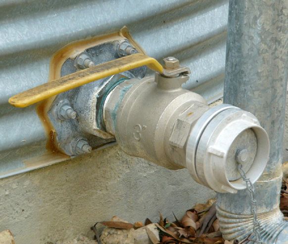
Classification of Vegetation Formations Chart
                                                                         Forests
                                                                         Open tree canopy dominated by eucalypt species
                                                                         (typically >10m in height) with crowns that touch or
                                                                         overlap. Canopy allows most sunlight to penetrate
                                                                         supporting growth of a prominent understorey layer
                                                                         varying between hard-leaved shrubs to luxuriant soft
                                                                         leaved shrubs, ferns and herbs.

                                                                         Woodlands
                                                                         Dominated by an open to sparse layer of eucalypts with
                                                                         the crowns rarely touching. Typically 15-35m high (may be
                                                                         shorter at sub-alpine altitudes). Diverse ground cover of
                                                                         grasses and herbs. Shrubs are sparsely distributed. Usually
                                                                         found on flat to undulating ground.

                                                                         Tall Heaths (Scrub)
                                                                         Shrubby vegetation greater than 2 metres tall. Principal
                                                                         plant species include banksias, spider flowers, wattles,
                                                                         legumes, eucalypts, tea-trees, paper barks, she oaks, grass
                                                                         trees, cord rushes and sedges. Grasses are scarce. Not
                                                                         found in arid and semi arid locations. Includes Hawkesbury
                                                                         Sandstone vegetation with scattered overstorey trees and
                                                                         predominantly healthy understorey and coastal heath. May
                                                                         include some mallee eucalypts in coastal locations.

                                                                         Short Heath (Open Shrub)
                                                                         Shrubby vegetation less than 2 metres in height. Often
                                                                         more open in canopy. Principal plant species include
                                                                         banksias, spider flowers, wattles, legumes, eucalypts, tea-
                                                                         trees, paper barks, she oaks, grass trees, cord rushes and
                                                                         sedges. Grasses are scarce. Not found in arid and semi
                                                                         arid locations.

                                                                         Rainforests
                                                                         Closed and continuous complex tree canopy composed
                                                                         of relatively soft, horizontally-held leaves. Generally
                                                                         lacking in eucalypts. Understorey typically includes ferns
                                                                         and herbs. Vines often present in canopy or understorey.
                                                                         Occur mainly in areas that are reliably moist, mostly
                                                                         free of fire and have soils of moderate to high fertility.
                                                                         Typically coastal and escarpment locations.

                                                                         Grasslands
                                                                         Dominated by perennial grasses and the presence
                                                                         of broad-leaved herbs on flat topography. Lack of
                                                                         woody plants. Plants include grasses, daisies, legumes,
                                                                         geraniums, saltbushes and copperburrs.

                                                                         Managed Land
                                                                         Non-vegetated or reduced vegetation areas such as:
                                                                         actively grazed pastures, maintained urban yards,
                                                                         maintained lawns, crops, orchards, vineyards, commercial
                                                                         nurseries, playing fields, golf course fairways, cleared
                                                                         parks, non-vegetated areas, formed roads and footpaths
                                                                         including cleared verges, waterways, etc.

                              Photos supplied by Hotspots Fire Project

 6   NSW RURAL FIRE SERVICE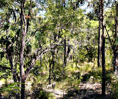
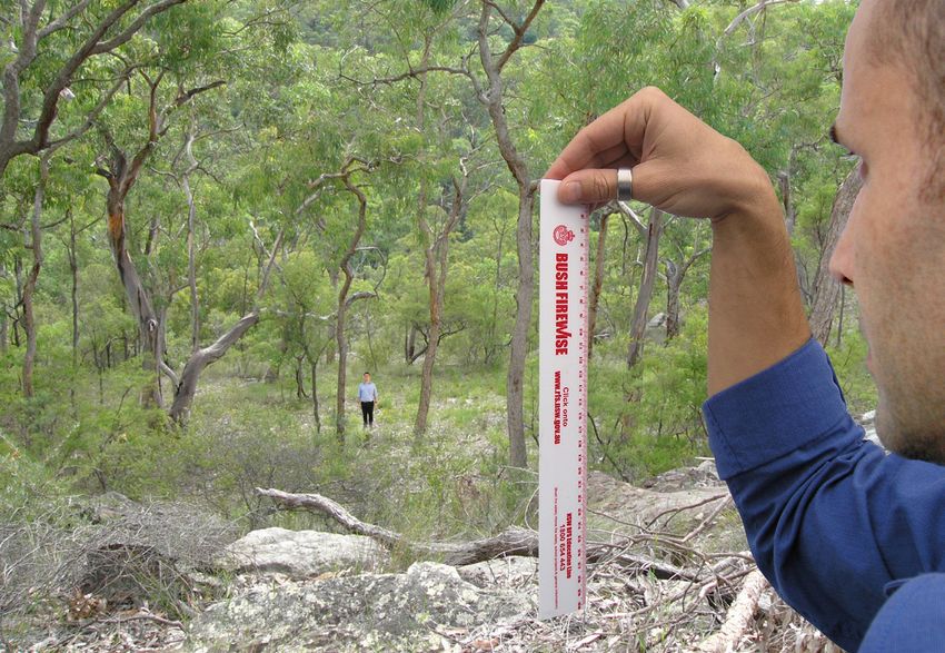
Step 2: Determine the distance from the              Simple slope assessment methodology.
building to the bush fire vegetation hazard          Method for estimating slope:
Identify whether vegetation is located on your
                                                     1. Pick a spot between 40 and 100m away and
property or on an adjoining property.
                                                        have an assistant of similar height stand as a
For vegetation located on your property measure         reference point. If you do not have an assistant
the distance from the building to vegetation and        pick a nearby tree as a reference point and tie a
record.                                                 bright ribbon or tape around the trunk at your
                                                        eye height.
If the vegetation is not located on your property
measure the distance from the building to your       2. Standing at the edge of the slope or at some
boundary.                                               point on the slope to be measured, hold one end
                                                        of a centimetre rule 30cm in front of your face,
This needs to be done for each aspect of the            level with your eye so that it hangs down.
building elevations that are exposed to bush fire
vegetation hazards.                                  3. Looking past the rule at the assistant's head or
                                                        marker, note how many centimetres on the rule
The measured distance is your APZ, see Part H for       their head is below your eye level.
more details on APZs.
                                                     4. The table below will convert this to a slope
                                                        range.
Step 3: Determine the effective slope
                                                     5. It is important to hold the end of the rule at eye
Measuring slope can be undertaken using various
                                                        level and let it hang straight down 30cm in front
tools such as clinometers and surveying equipment.
                                                        so that a reasonable level of accuracy is gained.
There are also commercially available phone
applications however the following method is
detailed where no equipment is provided.

                                                                       Figure 2

                                                                 SINGLE DWELLING APPLICATION KIT        7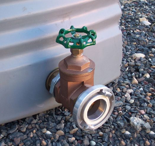
Table 1
Method for estimating slope

Measurement on rule (cm)                                  Converted slope range

Less than or equal to 0                                   Upslope or flat

0–3                                                       0 - 5º

3–5                                                       5 - 10º

5-8                                                       10-15º

                                          Effective slope
8-10                                                      15 -20º

        Effective slope (degrees)                      Managed asset protection zone
      Measure slope under vegetation         Not applicable for measurement of effective slope

                                                               downslope

                                                                   flat

                                                               upslope

 Figure 4

 Relative slope
 Shows how to refer to the slope in any direction relative to the building

8     NSW RURAL FIRE SERVICE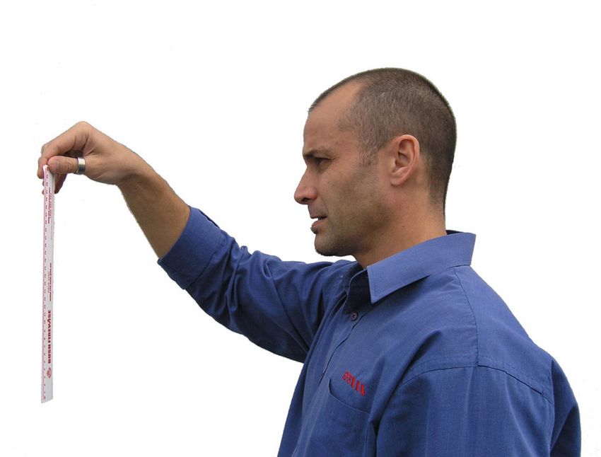
Step 4: Determine FFDI
To determine the relevant FFDI, refer to the NSW Local Government Areas FDI reference below to the
relevant Table number for each Council area.
Use the FDI value obtained as the appropriate FFDI value for your assessment.

NSW LOCAL GOVERNMENT AREAS FIRE DANGER INDEX (FDI)

FAR NORTH COAST             ILLAWARRA/                   NORTHERN SLOPES            EASTERN RIVERINA
(80)                        SHOALHAVEN (100)             (80)                       (80)
Ballina                     Kiama                        Gunnedah                   Albury
Byron                       Shellharbour                 Gwydir                     Coolamon
Clarence Valley             Shoalhaven                   Inverell                   Greater Hume
Kyogle                      Wingecarribee                Liverpool Plains           Junee
Lismore                     Wollondilly                  Tamworth Regional          Lockhart
Richmond Valley             Wollongong                                              Wagga Wagga
                                                         NORTH WESTERN
Tweed
                            FAR SOUTH COAST              (80)                       SOUTHERN
NORTH COAST (80)            (100)                        Moree Plains               RIVERINA (80)
Bellingen                   Bega Valley                  Narrabri                   Berrigan
Coffs Harbour               Eurobodalla                  Walgett                    Edward River
Mid-Coast                                                Warrumbungle               Federation
                            MONARO ALPINE
Port Macquarie-Hastings                                                             Murray River
                            (80)                         UPPER CENTRAL
Kempsey                                                                             Murrumbidgee
                            Snowy Monaro                 WEST PLAINS (80)
Nambucca                                                 Bogan
                            SOUTHERN RANGES                                         NORTHERN
GREATER HUNTER              (100)
                                                         Coonamble                  RIVERINA (80)
(100)                                                    Gilgandra                  Carrathool
                            Queanbeyan - Palerang
Cessnock                                                 Warren                     Griffith
                            Goulburn Mulwaree
Dungog                                                                              Hay
                            Upper Lachlan                LOWER CENTRAL
Lake Macquarie                                                                      Leeton
                            Yass Valley                  WEST PLAINS (80)
Maitland                                                                            Narrandera
                                                         Bland
Muswellbrook                CENTRAL RANGES                                          Murrumbidgee
                                                         Dubbo Regional
                            (80)
Newcastle                                                Forbes
                            Bathurst                                                SOUTH WESTERN
Port Stephens                                            Lachlan                    (80)
                            Blayney
Singleton                                                Narromine                  Balranald
                            Cabonne
Upper Hunter                                             Parkes                     Wentworth
                            Cowra
                                                         Temora
GREATER SYDNEY              Lithgow                                                 FAR WESTERN (80)
REGION (100)                                             Weddin
                            Mid Western Regional                                    Bourke
All Sydney Metropolitan     Oberon
Councils                                                  SOUTHERN SLOPES           Brewarrina
                            Orange                       (80)                       Broken Hill
Plus Blue Mountains,
Hawkesbury and Central                                   Hilltops                   Central Darling
Coast                       NEW ENGLAND
                                                         Cootamundra - Gundagai     Cobar
                            (80)
                                                         Snowy Valleys              Unincorporated NSW
                            Armidale Regional
                             Glen Innes Severn
                            Tenterfield
                            Uralla
                            Walcha

                                                                     SINGLE DWELLING APPLICATION KIT     9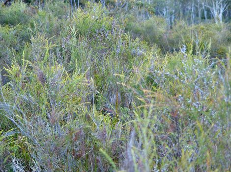
Step 5: Determine BAL Level                                                               This should be done for each side of the building.
 Match the relevant FFDI, appropriate vegetation,                                          Note: If your proposal is greater than 100m
 separation distance and effective slope to determine                                      from vegetation then there are no construction
 the BAL applicable to the building (or associated                                         requirements.
 area) from the following tables.

 Table 2
 Determination of bush fire attack level, FDI 80

                                                                                                    BUSH FIRE ATTACK LEVEL (BAL)
     KEITH VEGETATION FORMATION                                                   BAL-FZ       BAL-40          BAL-29          BAL-19           BAL-12.5
                                                                                           Distance (m) asset to predominant vegetation class
                             Rainforest
Table 3
Determination of bush fire attack level, FDI 100
BUSH FIRE ATTACK LEVEL (BAL)
KEITH VEGETATION FORMATION BAL-FZ BAL-40 BAL-29 BAL-19 BAL-12.5
Distance (m) asset to predominant vegetation class
RainforestTable 4
Determination of bush fire attack level, FDI 80
BUSH FIRE ATTACK LEVEL (BAL)
KEITH VEGETATION FORMATION BAL-FZ BAL-40 BAL-29 BAL-19 BAL-12.5
Distance (m) asset to predominant vegetation class
RainforestGrassland Deeming Provisions
The Deeming Provisions for grasslands provides an acceptable set of simplified requirements for building in
areas where grasslands are considered to be the only bush fire hazard. A site assessment as detailed in the
previous Steps 1 to 5.
Table 5
Grassland Deeming Provisions
BUSH FIRE PROTECTION MEASURE GRASSLAND DEEMING PROVISIONS
limited to a maximum of 15 degrees downslope;
minimum APZ of 20m is provided between the building and
unmanaged grass;
APZ the APZ is wholly within the boundaries of the development site;
and
the APZ is maintained as a mown area with grass heights less than
100mm.
construction in accordance with BAL-12.5 of AS3959-2018 and
Construction
any additional construction requirements in PBP 2019.
Access comply with the property access provisions in Part G.
Water supply comply with the water supply provisions in Part E.
comply with the relevant provisions in Appendix 4, PBP 2019
Landscaping noting that other vegetation bush fire hazards cannot be present
if these provisions are to apply.
Step 6: Determining BAL construction Where a distance of 50m or more of managed grass
requirements to a height of 100mm is to be provided, no further
BPMs are required. Where a minimum maintained
Once the appropriate BAL has been determined in
distance to unmanaged grass of at least 20m is to be
Step 5, AS3959-2018 and or/the NASH Standard
provided, the set of provisions shown in Table 5 apply.
2014 will be used to determine the construction
Where the Grassland Deeming Provisions cannot be
requirements for the proposed design.
achieved, the standard assessment process outlined
Where the proposed development is exposed to a in Steps 1 to 5 must be adopted. The maximum slope
grassland bush fire hazard only (and no other hazards for the Deeming Provisions is restricted to 15 degrees
exist within 140m of the proposed development), the downslope.
Grassland Deeming Provisions can be used instead of
For developments in grassland hazard areas where
the above assessment process, as detailed below.
the deeming provisions are applied, compliance with
Table 5 is required.
SINGLE DWELLING APPLICATION KIT 13Part D Part E
Flame Zone Water Supplies
If your property’s category of bush fire attack is Where reticulated water supply is not provided or
flame zone, your proposal will not be complying is considered inadequate, an on site stored supply
with the acceptable solutions of PBP 2019 and your of water for firefighting will be required. Reticulated
DA will be referred to the NSW RFS. water supplies are those that are piped by council or a
water authority.
In many situations, compliance with section 9 of
AS3959-2018 may be sufficient to meet PBP 2019. Applicants should ensure they have adequate supplies
of water (i.e. tanks, pools, etc) that will be available
If your building is in the flame zone there are options if the mains system fails or is not available (i.e. rural
you can choose between: areas). Additional water can be either a dedicated or
You can obtain the services of a suitably qualified static water supply.
bush fire consultant to undertake a performance Static water supply is an alternative source of water
assessment and make recommendations to that is guaranteed in a bush fire event, such as a
Council or; rainwater tank, swimming pool or dam in addition to
You can provide your assessment and report the mains water supply that could be utilised to fight
using Chapter 9 of AS3959-2018 or the NASH fires.
standard 2014 as the basis for the relevant bush
fire protection measures for your proposed site.
Keep in mind that another option is to site the
building outside the flame zone by allocating more
land for an increased APZ. This will permit you to
lower your required level of construction.
If you choose to prepare your own BFAR for a BAL-
FZ situation you may need to introduce additional
bush fire protection features in order to obtain
Council approval. This is particularly relevant where
a minimum setback distance of 10m is not provided
to the hazard vegetation.
If at least a 10m setback is not able to be provided
between the building and the bush fire hazard then
AS3959-2018 requires all building elements to be
tested to a specified bush fire testing standard.
For renovations and alterations the NSW RFS may
also recommend that improvements are made to
existing buildings in order to provide improved bush
fire safety. These may include:
Screening of existing windows for ember
protection;
Gutter guards, leafless gutters and valleys; and
Sealing of weep holes and other openings and
external doors.
14 NSW RURAL FIRE SERVICEWater Requirements:
Underground tanks have an access hole of
The water supply requirements for development are
200mm to allow tankers to refill direct from the
as follows:
tank;
Reticulated water is to be provided to the
A hardened ground surface for truck access is
development, where available; and
supplied within 4m;
A static water supply is provided where no
Above-ground tanks are manufactured from
reticulated water is available.
concrete or metal;
Fire hydrant spacing, design and sizing comply
Raised tanks have their stands constructed from
with the relevant clauses of AS 2419.1:2005;
non-combustible material or bush fire-resisting
Hydrants are not located within any road timber (see Appendix F of AS 3959);
carriageway; and
Unobstructed access can be provided at all
Fire hydrant flows and pressures comply with the times;
relevant clauses of AS 2419.1:2005.
Underground tanks are clearly marked;
All above-ground water service pipes external to
Tanks on the hazard side of a building are
the building are metal, including and up to any
provided with adequate shielding for the
taps.
protection of firefighters;
Where no reticulated water supply is available,
All exposed water pipes external to the building
water for firefighting purposes is provided in
are metal, including any fittings;
accordance with Table 6 below.
Where pumps are provided, they are a minimum
A connection for firefighting purposes is located
5hp or 3kW petrol or diesel-powered pump, and
on the non-hazard side and away from the
are shielded against bush fire attack; any hose
structure; 65mm Storz outlet with a ball valve is
and reel for firefighting connected to the pump
fitted to the outlet;
shall be 19mm internal diameter; and
Ball valve and pipes are adequate for water flow
Fire hose reels are constructed in accordance
and are metal;
with AS/NZS 1221:1997, and installed in
Supply pipes from tank to ball valve have the accordance with the relevant clauses of AS
same bore size to ensure flow volume; 2441:2005.
Figure 5 Figure 6
Gate Valve Ball Valve
65mm Storz fitting
Table 6
Dedicated water supply requirements for proposals where reticulated water supplies are not provided.
Development Type Water Requirement
Residential Lots (1 ha 20,000 l/lot
5,000 l/unit up to
Townhouse/Unit Style (e.g. Flats including Dual Occupancy)
20,000l maximum.
Note: The figures in the above table are additional to Basix or any other requirements.
SINGLE DWELLING APPLICATION KIT 15Part F In circumstances where this cannot occur, the
following requirements apply:
Gas Supplies Property access roads are two-wheel drive, all-
The plans submitted with your application need to weather roads.
show the location and type of bottled gas services The capacity of road surfaces and any bridges/
within the property. causeways is sufficient to carry fully loaded
Reticulated or bottled gas needs to be installed and firefighting vehicles (up to 23 tonnes), bridges
maintained in accordance with AS/NZS 1596:2014 and causeways are to clearly indicate load rating.
- The storage and handling of LP Gas and the There is suitable access for a Category 1 fire
requirements of relevant authorities. Metal piping is appliance to within 4m of the static water supply
to be used. where no reticulated supply is available.
All fixed gas cylinders are to be kept clear of all At least one alternative property access road is
flammable materials to a distance of 10m and provided for individual dwellings or groups of
shielded from bush fire hazards on the hazard side dwellings that are located more than 200m from
of the installation. a public through road;
If gas cylinders need to be kept close to the minimum 4m carriageway width;
building, the relief valves are to be directed away in forest, woodland and heath situations,
from the building and at least 2m away from any rural property roads have passing bays every
combustible material so that they do not act as a 200m that are 20m long by 2m wide, making a
mechanism for fire spread. All connections are to be minimum trafficable width of 6m, at the passing
metal. bay;
a minimum vertical clearance of 4m to any
Polymer sheathed flexible gas supply lines and overhanging obstructions, including tree
connections are not to be used. branches;
Part G property access must provide a suitable turning
area in accordance with PBP 2019 Appendix 3;
Access curves have a minimum inner radius of 6m and
The following identifies the requirements from are minimal in number to allow for rapid access
PBP 2019 that are required for property access. and egress;
Not all access requirements will be applicable the minimum distance between inner and outer
to a particular development due to site specific curves is 6m;
conditions (e.g. some dwelling sites may be located the crossfall is not more than 10 degrees;
physically close enough to a public road to avoid the
maximum grades for sealed roads do not exceed
need for passing bays). However where compliance
15 degrees and not more than 10 degrees for
with the following requirements is not possible, a
unsealed roads; and
performance based solution may be needed.
a development comprising more than three
There are no specific access requirements in an dwellings has formalised access by dedication of
urban area where an unobstructed path (no greater a road and not by right of way.
than 70m) is provided between the most distant
external part of the proposed dwelling and the Note: Some short constrictions in the access may
nearest part of the public access road (where be accepted where they are not less than 3.5m
the road speed limit is not greater than 70kph) wide, extend for no more than 30m and where
that supports the operational use of emergency the obstruction cannot be reasonably avoided
firefighting vehicles. or removed. The gradients applicable to public
roads also apply to community style development
property access roads in addition to the above.
16 NSW RURAL FIRE SERVICEPart H
Asset Protection Zones (APZ) Although it is possible to build using BAL-Flame Zone
construction levels, providing a minimum defendable
An APZ is an area between a bush fire hazard and space and APZs wherever possible will increase the
a building which is managed to minimise fuel loads, resilience of your home in bush fire situations.
inhibit fire paths and reduce the effects of heat,
flame, ember and smoke attack. It keeps the effects
of the fire away from the building. The size of the APZ
is based on vegetation type, slope and BAL provided.
Figure 7
Asset Protection Zone (APZ)
Asset Protection Zone
Bushland APZ Building Envelope
horizontal considerations
Bushland APZ Building Envelope
downslope
vertical considerations
The APZ should be contained wholly within the as a legally enforceable easement is provided and
proposed development site, but can also include submitted with your development application.
existing roads. Unmanaged land or land that is not to
It is expected that the APZ will be maintained by the
be managed will not be considered as an APZ.
owner of the land being developed. See Standards
APZ’s on adjoining managed land will only be for APZ for more information about design &
considered under exceptional circumstances and maintenance (available from the NSW RFS website).
then only when an agreed legal arrangement, such
SINGLE DWELLING APPLICATION KIT 17Dictionary
Additional definitions can be found in Planning for Bush Fire Protection 2019.
Acceptable Solution Bush Fire Assessment Report (BFAR)
The acceptable solutions that meet the requirements A report submitted in support of a development
(being Chapters 1-8) of Australian Standard AS3959- application by an applicant which determines the
2018, Construction of buildings in bushfire-prone extent of bush fire attack to a development and the
areas or Planning for Bush Fire Protection 2019 measures to be provided to meet PBP 2019.
(PBP). Appendix 2 (A2.2) of Planning for Bush Fire
Protection 2019 provides the information
Performance based solution
requirements for a bush fire assessment. See also
A method of complying with the performance
clause 46 of the Rural Fires Regulation.
criteria other than by acceptable solutions.
Development Application (DA)
AS3959-2018
Application normally made to the local council for
Australian Standard AS3959-2018, Construction
consent to carry out development such as building,
of buildings in bushfire-prone areas, specifies
subdivision, or the use of a building or land.
construction standards applicable to buildings in bush
fire prone areas. Flame zone
The distance from a bush fire at which there is
Asset Protection Zone (APZ)
significant potential for sustained flame contact to
An area surrounding a development managed to
a building. Determined by the calculated distance
reduce the bush fire hazard to an acceptable level.
at which the radiant heat of the design fire exceeds
The width of the required APZ will vary with slope,
40kW/m² or calculated by the sustained flame
vegetation and construction level. The APZ consists
length, whichever is the lesser.
of an area maintained to minimal fuel loads so that a
fire path is not created between the hazard and the Forest Fire Danger Index (FFDI)
building. A measure of the degree of danger of bush fire in
Australian forests. This index combines a record
Building footprint
of dryness, based on rainfall and evaporation, with
The area shown on a plan over which a building is
meteorological variables for wind speed, temperature
proposed to be erected.
and humidity. FDI information can be found on the
Bush fire prone land NSW RFS website www.rfs.nsw.gov.au.
Is an area of land that can support a bush fire or is Grasslands
likely to be subject to bush fire attack. Bush fire prone
Grassed areas capable of sustaining a fire. Under AS
area is land mapped for a local government area that
3959 2018, this is identified as low open shrubland,
identifies the vegetation classifications and associated
hummock grassland, closed tussock grassland,
buffer zones. Bush Fire Prone Land Maps are prepared
tussock grassland, open tussock, sparse open
by local councils and certified by the Commissioner
tussock, dense sown pasture, sown pasture, open
of the NSW RFS under section 10.3(2) of the
herbfield, and sparse open herb field.
Environmental Planning and Assessment Act 1979.
Grass, whether exotic or native, which is regularly
Bush fire protection measures (BPMs) maintained at or below 10cm in height (including
Are a range of measures available to minimise maintained lawns, golf courses, maintained public
the risk arising from a bush fire. BPMs include reserves, parklands, nature strips and commercial
APZs, construction standards, suitable access nurseries) is regarded as managed land.
arrangements, water and utility services, emergency
management arrangements and landscaping.
18 NSW RURAL FIRE SERVICETEAR OUT AND ATTACH THIS BUSH FIRE ASSESSMENT REPORT WITH YOUR APPLICATION TO COUNCIL
SECTION TWO
BUSH FIRE ASSESSMENT REPORT
PART A: Property details
Applicant name: . ........................................................... ............................................................................................................................ . . . . . . . . . . .
Contact phone numbers Home: ............................................................................................... Mobile:....................................................... . . . . . . . . . . .
Council: ........................................................................................................................................................................................................... . . . . . . . . . . .
Council reference (if known): . ........................................................................................................................................................... . . . . . . . . . . . .
Lot: ................................................................................................................................................................................................................... . . . . . . . . . . . .
DP: . ....................................................................................... ........................................................................................................................... . . . . . . . . . . . .
Address to be developed: .................................................................................................................................................................... . . . . . . . . . . .
My property is on Bush Fire Prone Land: Yes No
PART B: Type of proposal
Type of Proposal: ......................................................................................................................................................................................................................................................................................
New Building Urban Isolated Rural Rural Residential
Alteration/Additions to an existing building
Proposal Description: e.g. two storey house with attached
...............................................................................................................................................................................................................................
...............................................................................................................................................................................................................................
Copy of plans attached: Yes No
SINGLE DWELLING APPLICATION KIT 19PART C: Bush fire attack and level of construction
Step 1
Assess the vegetation hazard in all directions
Category North East South West
Keith vegetation Rainforest Rainforest Rainforest Rainforest
group
Forest Forest Forest Forest
Grassy and Semi-Arid Woodland Woodland Woodland
Woodland
Forested Wetland Forested Wetland Forested Wetland Forested Wetland
Tall Heath Tall Heath Tall Heath Tall Heath
Short Heath Short Heath Short Heath Short Heath
Arid-Shrubland Arid-Shrubland Arid-Shrubland Arid-Shrubland
Freshwater Wetlands Freshwater Wetlands Freshwater Wetlands Freshwater Wetlands
Grasslands Grasslands Grasslands Grasslands
Managed Land Managed Land Managed Land Managed Land
Copy of any relevant photos attached: Yes No
Step 2
Determine the distance from the building to the bush fire vegetation hazard
Aspect North East South West
Distance .............. m .............. m .............. m .............. m
20 NSW RURAL FIRE SERVICEStep 3
Determine the effective slope that will influence bush fire behaviour in each direction
Category North East South West
Slope under the upslope/flat upslope/flat upslope/flat upslope/flat
hazard (over 100m)
[in degrees] >0 to 5 >0 to 5 >0 to 5 >0 to 5
>5 to 10 >5 to 10 >5 to 10 >5 to 10
>10 to 15 >10 to 15 >10 to 15 >10 to 15
>15 to 20 >15 to 20 >15 to 20 >15 to 20
Step 4
Determine the FFDI that applies to your local government area. Circle the relevant FFDI below
FFDI: 100 80
Step 5
Match the relevant FFDI, vegetation, distance and slope to determine the required BAL.
Identify the BAL for each direction, select the highest level for the entire building and record below. Note
BAL-12.5 is the lowest construction level within the scope of AS3959-2018.
Bush Fire Attack Level: BAL- FZ BAL- 29 BAL-12.5
BAL- 40 BAL-19 No requirement
Step 6
Determining BAL construction requirements
Once the appropriate BAL has been determined in Step 5, AS3959-2018 and or/ the NASH Standard 2014 will
be used to determine the construction requirements for the proposed design.
Does your proposal meet the construction requirements for the BALs required as per AS3959-2018 and the
NASH Standard (2014):
Yes No
SINGLE DWELLING APPLICATION KIT 21Grassland Deeming Provisions Assessment
This assessment is only required where the deeming provisions are to be used. Where the deeming provisions
are not to be used, previous Steps 1 to 6 in Part C must be applied. Tick which box below applies to individual
circumstances:
An APZ of 50m or more can be provided – this can be considered to meet PBP 2019, no further bush fire
protection measures are required
An APZ of 20-49m can be provided – comply with Grassland Deeming Provisions requirements in the
following Table
An APZ of less than 20m is provided or the standard assessment process is proposed - use the
assessment process identified in Steps 1 to 6 above
Grassland Deeming Provisions
BUSH FIRE PROTECTION MEASURE GRASSLAND DEEMING PROVISIONS
limited to a maximum of 15 degrees downslope;
minimum APZ of 20m is provided between the building and
unmanaged grass;
APZ
the APZ is wholly within the boundaries of the development site; and
the APZ is maintained as a mown area with grass heights less than
100mm.
construction in accordance with BAL-12.5 of AS3959-2018 and any
Construction
additional construction requirements in PBP 2019.
Access comply with the property access provisions in Part G.
Water supply comply with the water supply provisions in Part E.
comply with the relevant provisions in Appendix 4 of PBP 2019,
Landscaping noting that other vegetation bush fire hazards cannot be present if
these provisions are to apply.
22 NSW RURAL FIRE SERVICEPART D: Flame zone
Provide details and justification for any additional bush fire protection measures required for a performance
based solution.
PART E: Water supplies
Does your property have a reticulated water supply?; If so, please provide details on the distance to the
nearest fire hydrant on your site plan.
Reticulated water supply is available: Yes No
Distance ........................... (m) to hydrant from house.
Do you have or do you plan to have a dedicated water supply for firefighting purposes?
Yes No
Development Type Water Requirement Planned Existing
Residential Lots (1 ha 20,000 l/lot
Townhouse/Unit Style 5,000 l/unit up to 20,000l
(e.g. Flats including Dual Occupancy) maximum.
Do you have or do you plan to have a static water supply (e.g. pool, tank or dam)?
Include approximate size in litres and also include tank material if using a tank:
Water supply type Capacity Construction material Planned Existing
e.g. pool 50,000l Above ground rolled steel with plastic liner
NOTE: Check with your local council concerning their Local Environmental Plan (LEP) or
their Development Control Plan (DCP) as this may dictate the type and size of tank.
SINGLE DWELLING APPLICATION KIT 23PART F: Gas supplies Do you have reticulated or bottled gas? Yes No Type of gas: Reticulated gas: Yes No Bottled gas: Yes No NOTE: When attaching development plans please ensure they clearly show location and details of electricity and gas (where relevant) on your property. Part G: Access Does the development proposal meet the requirements as defined in this document? Yes No 24 NSW RURAL FIRE SERVICE
This document has been designed for owner/buiders as well as architects, building designers and
draftspersons who wish to submit plans for building or modifying an existing building in a Bush Fire
Prone Area. This document has been designed to support you, and provide you with a process to
follow that will assist you to meet the current requirements for bush fire protection.

© State of New South Wales through the NSW RURAL FIRE SERVICE, April 2020

The NSW RURAL FIRE SERVICE (NSW RFS) encourages the availability, dissemination and exchange
of public information. You may copy, distribute, display, download and otherwise freely deal with
this material for personal, in-house or non‑commercial use, on the condition that you include the
copyright notice © State of New South Wales through the NSW RURAL FIRE SERVICE 2019 on all
such uses. In the event that you wish to copy, distribute, display, download, store, or use this material
for a purpose other than personal, in‑house or non-commercial use, you must obtain permission from
the NSW RFS by writing to the following address:

Commissioner
NSW RURAL FIRE SERVICE
Locked Mall Bag 17
Granville NSW 2142

DISCLAIMER STATEMENT
While the material within this SINGLE DWELLING APPLICATION KIT is current at the time of writing
changes in circumstances after the time of publication may impact on the accuracy of the material.
Individuals are responsible for ensuring they have the most current version of this publication.

The information and material contained herein is general in nature and is intended for your use and
information. The NSW RURAL FIRE SERVICE (NSW RFS) disclaims, to the extent permitted by law,
all warranties, representations or endorsements, express or implied, with regard to the material
contained herein. The NSW RFS does not warrant or represent that the material contained herein is
free from errors or omissions, or that it is exhaustive. Users should exercise their own skill and care
with respect to its uses. You must not assume that this material will be suitable for the particular
purpose that you had in mind when using it.

The NSW RFS disclaims any liability (including but not limited to liability by reason of negligence) to
the users of the material for any loss, damage, cost or expense whether direct, indirect, consequential
or special, incurred by, or arising by reason of, any person using or relying on the material and
whether caused by reason of, any error, omission or misrepresentation in the material or otherwise.
Users of the Website will be responsible for making their own assessment of the material and should
verify all relevant representations, statements and information with their own professional advisers.

Postal address                             Street address                             T (02) 8741 5555
NSW Rural Fire Service                     NSW Rural Fire Service                     F (02) 8741 5550
Locked Bag 17                              4 Murray Rose Avenue                       www.rfs.nsw.gov.au
GRANVILLE NSW 2142                         Sydney Olympic Park NSW 2127

Social Media
   www.facebook.com/nswrfs/
   @NSWRFS

                                                                                       SINGLE DWELLING APPLICATION KIT   25
You can also read