SITUATION UPDATE - ReliefWeb
←
→
Page content transcription
If your browser does not render page correctly, please read the page content below
SITUATION UPDATE
                                 MASSIVE FLOODS IN GREATER JAKARTA AREA
                                                                                                                                 No.   1
                                                 INDONESIA
                                   Sunday, 5 January 2020, 20:00 hrs (UTC+7)

This Situation Update is provided by the AHA Centre for use by the ASEAN Member States and relevant stakeholders. The information presented is
collected from various sources, including but not limited to, ASEAN Member States’ government agencies, UN, IFRC, NGOs, and news agencies.

1. HIGHLIGHTS

a. Due to the monsoon season and heavy rainfall since 31 December 2019, the Greater
   Jakarta area was affected by massive floods and landslides reported. As of 4
   January 2020, a total of 308 sub-districts in 103 districts of 3 provinces, i.e. Jakarta,
   West Java, and Banten, are flooded since 1 January 2020. The AHA Centre has
   issued Flash Updates on the situation, which available here (Flash Update No.1, Flash
   Update No.2. Flash Update No.3).
b. The National Disaster Management Authority of Indonesia (BNPB) has been leading
   national coordination with other national agencies to support the local disaster
   management authority (BPBD). BNPB has mobilised support to the affected people
   by dispatching relief items, deploying personnel, disseminating information, and
   establishing evacuation centres.

                                                        SITUATION UPDATE                                                                         1
c. In-country ASEAN Emergency Response and Assessment Team (ASEAN-ERAT)
   Indonesia is mobilised to reinforce BNPB in providing technical assistance in the
   management of evacuation site and provision of minimum services at the Jati Asih
   evacuation site of BNPB.

2. SUMMARY OF EVENTS, FORECAST AND ANTICIPATED RISK

Summary of events

a. The occurrence of the Northeast Monsoon has brought a continuous heavy rain in
   Jakarta and its surrounding area, known as the Greater Jakarta (JABODETABEK:
   Jakarta, Bogor, Depok, Tangerang, and Bekasi), which consists of three provinces
   namely Banten, Jakarta, and West Java. The floods started in the early morning of 1
   January 2020, and have spread out throughout the day.

b. BMKG reported that the recorded rainfall intensity during 1 January 2020 at Halim
   Perdanakusuma Air Force Base in East Jakarta reached up to 377mm/day. This
   number is the highest compared to the rainfall intensities that also caused massive
   flooding in Jakarta a few years back, such as 2007 (340 mm/day) flooding event. In
   addition, BMKG also reported that the rain may still continue until 7 January 2020,
   with a plausible high tide up to 30-60 cm height occurs in northern Jakarta during 5-
   6 January 2020 which may detain water volume inland.

Forecast and anticipated risk

c. The latest weather analysis reported by BMKG indicates that potential rainy weather
   may still occur in the Greater Jakarta, as the wet air from the southern Sumatra
   transverse to Java due to the Northeast Monsoon season.

Figure 1: Left-Snapshot of HIMAWARI-8 EH Satellite, showing cloud temperatures
based on radiation observation. Black or blue colour in the scale bar means that there is
no significant cloud formation. On the contrary, orange to red colour means that colder
temperature with bigger potential for cloud formation that may cause rains. Right-
Snapshot of wind and pressure conditions at 3000 feet high, showing the prevailing
winds in Java area tends to move easterly. Both pictures are taken as of 5 January 2020.

                                  SITUATION UPDATE                                      2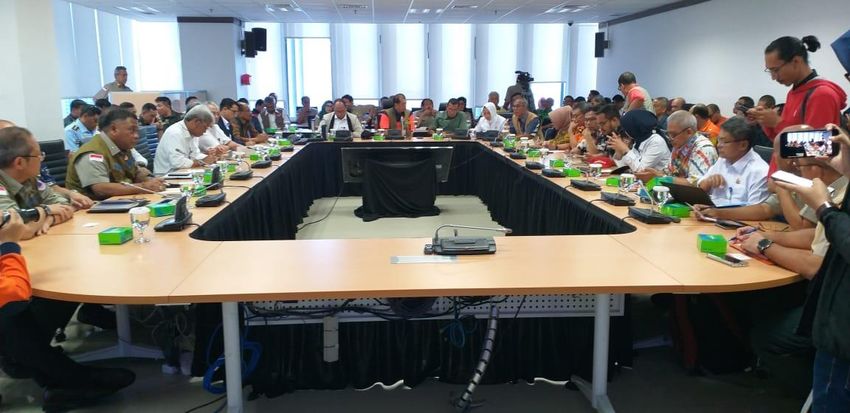
d. BMKG also stated that from 11 to 15 January 2020 wet atmospheric conditions from
   African Region may land in Indonesia, which includes Greater Jakarta, middle part of
   Sumatra, Java, South Kalimantan, and South Sulawesi. These areas are potentially
   showered by extreme heavy rains and may recur at the end of January and the end
   of February.

3. ASSESSMENT OF DAMAGE, IMPACT, AND HUMANITARIAN NEEDS

a. According to National Disaster Management Authority (BNPB), the immediate needs
   at this point of time are the following:
    ● Essentials: Food, drinking water, clean water, latrines, clothes, and blankets.
    ● Health: Rescue teams, paramedics, medicine, and trauma healing.
    ● Others: Rubber boats, tarpaulins, and generator sets.

b. The emergency status alert has been declared by mayor in affected cities and
   regencies. The Indonesia's National Disaster Management Authority (BNPB) is
   actively responding to this event to augment the efforts of the local disaster
   management authorities (BPBDs) in managing the emergency response.

c. The breakdown of total impacts by location can be seen below. The data is valid as
   of 4 January 2020. Below discussion is limited to the scope of the Greater Jakarta
   Area. During this flood response, BNPB is also collecting data from other areas in
   Banten and West Java Provinces, that is not included in this analysis such as Lebak
   Regency, Karawang Regency, Bandung City, Bandung Regency, etc.

Table 1: Figures for impacts in the 12 affected cities/regencies which are included in the
Greater Jakarta area. Data is obtained from BNPB as of 04 January (Saturday) 2020.

                                   SITUATION UPDATE                                      3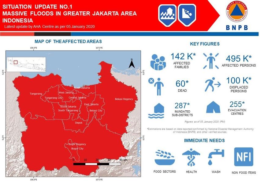
Figure 2: Stack bar graph of total displaced people over time. It shows that on 1-2
January the collected data only gathered from Jakarta area. The data from Bekasi was
received on 3 January 2020 and increased the total displaced persons to more than
100.000. As per yesterday (4 January 2020), Bekasi City remains as the most affected
area in the impact of the floods in the Greater Jakarta. There is an increment of total
displaced persons on 2 January 2020 due to the collected numbers in West South
Jakarta, although the floods have receded in several areas, particularly in Central and
North Jakarta Cities.

                                 SITUATION UPDATE                                     4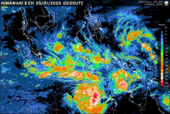
Figure 3: Map from the least to the most displaced people as per 4 January 2002 data.
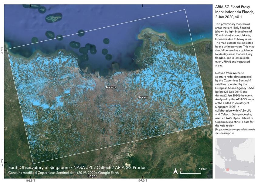
Figure 4: Map of inundated areas in Greater Jakarta shows in light blue pixels based on
synthetic aperture radar satellite data before 21 December 2019 and during (02 January
2020) the flood event. The analysis was done by the ARIA-SG team at the Earth
Observatory of Singapore (EOS), a member of Sentinel Asia. This map showed that
during 2 January the estimated floods event occurred particularly in Bekasi and
Tangerang area, while water in Jakarta, in fact, was also started to recede from the given
date.
SITUATION UPDATE 5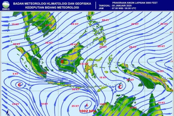
Figure 5: Clustered bar chart for the latest flow depth observed as of 4 January 2020
(blue), and maximum recorded flow depth since the beginning of the event until 3 January
2020 (grey). There is no reported inundation height in Central Jakarta, while West Jakarta
has certain flow depth anomalies as the current flow depth is almost two times higher
than the maximum current flow depth. The data from West Jakarta area was reported on
3 January 2020 and has no changes in its value as per latest update on 4 January 2020.

    From the Figure 3, the most affected regions based on the number of displaced
    people are in Bekasi City, which according to the satellite imagery analysis, the
    floods locations are more concentrated in Bekasi Regency, not in Bekasi City (Figure
    4). After we compare the flow depth for each location (Figure 5), there is a likelihood
    that of the most people displaced in Bekasi City are due to the higher inundation
    depth that could reach up to a maximum of 6 meters. While the flooded areas in
    Bekasi Regency is wider, some people who did not severely affected by the flood
    may choose to not be evacuated, while waiting for the water to recede. This happens
    in several areas of Jakarta, where people choose to stay in their less severely
    inundated house, or immediately went back home soon after the water recede.

d. It is reported that 256 schools and a total of 8,420 students, coming from special
   schools, playgroup, kindergarten, elementary, and high schools, have been affected
   in Jakarta province. Almost 48% of the affected students are male.

e. According to the Pacific Disaster Center’s (PDC) Hazard Brief Model, within more or
   less 30 km radius from Central Jakarta, the estimated exposure of these flood events
   resulted in a total of 18 million people that are potentially affected, direct or indirectly,
   with total residential exposure worth of 145 Billion USD, and educational exposure
   worth of 121 Billion USD.

                                     SITUATION UPDATE                                         6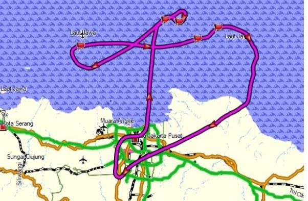
4. ACTIONS TAKEN AND RESOURCES MOBILISED

Response by the Government of Indonesia

a. The National Disaster Management Authority (BNPB) held a flood response
   coordination meeting at BNPB Headquarters in East Jakarta on 2 January 2020. The
   meeting was attended by various agencies from government, non-government,
   volunteers, and media. The Meteorology, Climatology, and Geophysics Agency of
   Indonesia (BMKG) foresees that the likelihood of heavy rainfall that caused floods in
   the Greater Jakarta may be recurring until February 2020.

      Figure 6: Coordination Meeting with Other Relevant Agencies at Graha
                    BNPB on 2 January 2020. Source: BNPB

b. The Agency for the Assessment and Application of Technology (BPPT) BPPT, along
   with the BNPB and the Indonesian Military (TNI), deployed two types of aircraft for
   the weather modification mission (Teknologi Modifikasi Cuaca - TMC). This mission
   aimed to reduce the high rainfall intensity the Greater Jakarta up to 30%, as more
   heavy rainfall potentially occurs in Jakarta up to 7 January 2020, according to BMKG.

   Figure 7: Weather modification technology to decrease rainfall intensities in Jakarta
   Greater Area. Purple line shows the track of cloud seeding that has been conducted
   on 3 January 2020.

c. BNPB has mobilised support to the affected people by dispatching relief items,
   deploying personnel, disseminating information, and establishing evacuation

                                  SITUATION UPDATE                                     7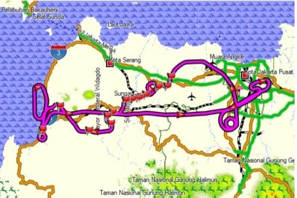
centres. The Head of BNPB and the Coordinating Minister for Human Development
   and Cultural Affairs visited this evacuation site in Jati Asih, Bekasi on 4 January 2020
   afternoon. The High-level Officials met the BPBD Bekasi and inform that the national
   on-call budget amounting 1 Billion IDR (approx. 72,000 USD) is made available for
   BPBD Bekasi for the operationalisation of emergency response including clearing the
   roads.

Figure 8: Coordinating Minister for Human Development and Cultural Affairs distributed
          1 billion IDR (approx. 72,000 USD) for BPBD Bekasi. Source: BNPB

d. BNPB together with several partners have created a joint platform to monitor
   activities and situation on the ground, such as a joint portal for Greater Jakarta floods
   response (link) and Desk Relawan BNPB (link). Both of these platforms available in
   Bahasa Indonesia.
e. Health Crisis Center, Ministry of Health (MoH) in Indonesia, has mobilised Emergency
   Medical Team (EMT) with priority for life saving, deployed rubber boats for evacuation
   and medical team transportation, developed medical support point on each location
   of evacuation centre and provided medical and psychosocial services.
f. Ministry of Health stands ready to support the health sectors, in regards to the floods
   victims. However, most of the preparedness are based in public health centres,
   which centralised in Jakarta area. In addition, more than 11,000 health personnel are
   in standby in Jakarta area, while other affected area have less than 500 health
   personnel, including Bekasi City, the most affected area, in which allotted 348
   personnel as of 03 January 2020 report.

                                   SITUATION UPDATE                                       8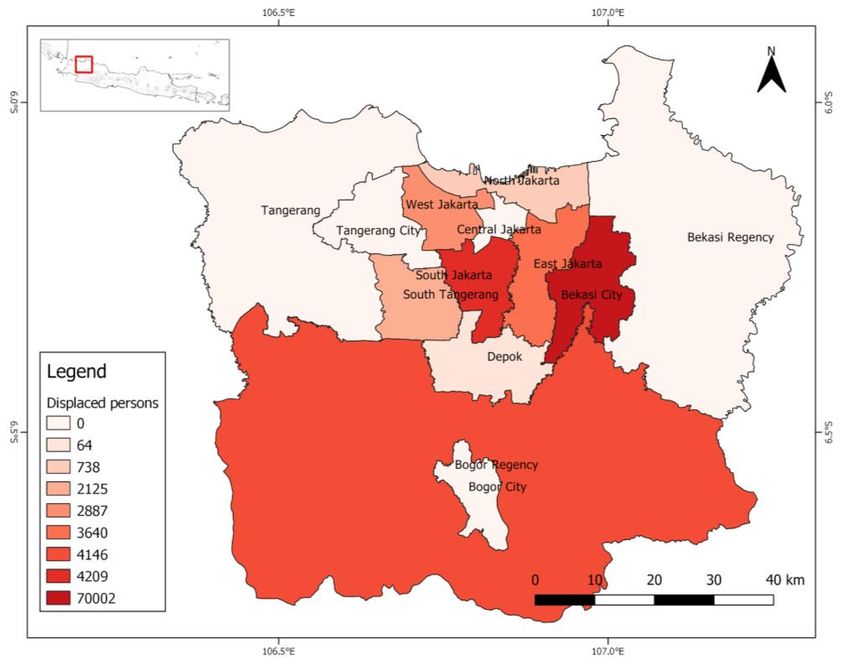
Response by the AHA Centre

a. The AHA Centre has expressed condolences to Indonesia on 2 January 2020 and
   mobilised reinforcements to the EOC of BNPB in the area of information
   management and other technical assistance due to massive floods in the Greater
   Jakarta.

b. The In-country ASEAN Emergency Response and Assessment Team (ASEAN-ERAT)
   Indonesia is mobilised to reinforce the Government of Indonesia in providing
   technical assistance in the management of the evacuation site and provision of
   minimum services at the Jati Asih evacuation site of BNPB.

Figure 9: In-country ASEAN-ERAT Indonesia visited the evacuation site of BNPB in Jati
Asih, Bekasi on 4 January 2020. Source: the AHA Centre

c. The AHA Centre Emergency Operations Centre (EOC) is on Red alert and is on stand-
   by to further augment the effort of BNPB since 3 January 2020.

d. The AHA Centre is in closely coordination with partners (Sentinel Asia, EOS ARIA-
   SG, PDC, UNITAR-UNOSAT) for the satellite imageries, and spatial analysis.

                                 SITUATION UPDATE                                  9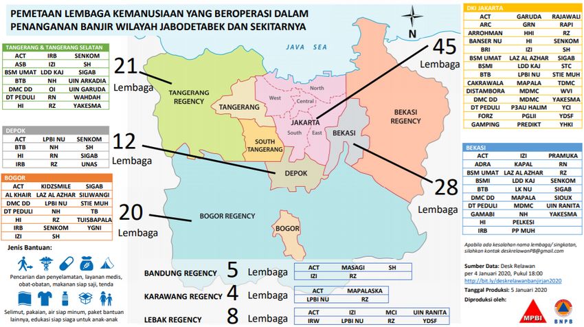
Response by ASEAN Member States

e. A letter of condolence from National Committee for Disaster Management (NCDM),
   Kingdom of Cambodia has been transmitted to Head of BNPB as a form of solidarity
   in ASEAN region.

Response by Other Partners

f. The Government of Indonesia through the BNPB confirms that national capacity and
   resources remain sufficient to support emergency response and recovery led by
   BNPB. Hence, only local NGOs can deploy their personnel to the affected area.
   Accordingly, the incident is within the national capacity and international assistance
   is not required.
g. Some local NGOs have deployed their personnel to some affected areas. MPBI
   (Masyarakat Penanggulangan Bencana Indonesia) and Desk Relawan BNPB have
   developed an online form to collect information on local NGOs deployment activities
   (link). The following is the number of NGOs and their deployed personnel.

      Table 2: Number of NGOs and their deployed personnel. Source: the AHA Centre
                         Source Desk Relawan BNPB and MPBI.

     Based on the available data, most of the deployed personnel and local NGOs are still
     mainly operating the assistance in Jakarta area, while several available reports show
     that Bekasi City is the most affected area. Further analysis and ground validation will
     be necessary to identify gaps during the post-disaster events.

h. As Emergency Observation Request for Sentinel Asia activated by the AHA Centre
   through OPTEMIS system, Advanced Rapid Imaging & Analysis team in Earth
   Observatory Singapore (EOS ARIA-SG) have supported to analyse flood extents as
   mentioned in Figure 4 and Figure 10.

                                    SITUATION UPDATE                                     10
5. RECOMMENDATIONS AND PLAN OF ACTIONS
Recommendations
a. The limited data and gaps for the assessment maybe reinforced by participation of
humanitarian agencies and other volunteers in BNPB‘s joint platform, such as Desk
Relawan BNPB (link) and the BNPB’s joint portal for the Greater Jakarta floods
response (link). Both of these platforms are available in Bahasa Indonesia.
b. Further observation for understanding gaps analysis will be needed as several
analyses show that the most affected area is located in Bekasi City while currently
most of the available support by other partners are still mainly in Jakarta area.
c. As reported by BMKG, the Greater Jakarta will still experience massive rains until
February 2020.
The AHA Centre’s plans
d. The AHA Centre will join BNPB Emergency Operations Centre (EOC) meeting on
Monday, 6 January 2020, to oversee plausible support in the scope of information
management.
e. The AHA Centre will provide further situation updates as the situation progresses and
more information is available.
6. IMAGERY
SITUATION UPDATE 11Figure 10: Map of affected areas in Greater Jakarta showing the likely flooded areas (light
blue pixels), based on synthetic aperture radar satellite data before (21 December 2019)
and during (02 January 2020) the flood event. The analysis was done by the ARIA-SG
team at the Earth Observatory of Singapore (EOS), member of Sentinel Asia.
Figure 11: Infographics of deployed personnel by local NGOs. Source: Desk Relawan
BNPB
Prepared by:
The AHA Centre - Emergency Operations Centre (EOC)
ABOUT THE AHA CENTRE
The AHA Centre - ASEAN Coordinating Centre for Humanitarian Assistance on disaster
management - is an inter-governmental organisation established by 10 ASEAN Member States –
Brunei Darussalam, Cambodia, Indonesia, Lao PDR, Malaysia, Myanmar, Philippines, Singapore,
Thailand and Viet Nam - to facilitate the cooperation and coordination among ASEAN Member
States and with the United Nations and international organisations for disaster management and
emergency response in the region.
The ASEAN Coordinating Centre for Humanitarian Assistance on disaster management
(AHA Centre), Graha BNPB 13th Floor, JL Raya Pramuka Kav 38, East Jakarta, 13210, Indonesia
Phone: +62-21-210-12278 │ www.ahacentre.org │ email: info@ahacentre.org
Contact:
1) Grace Endina, Preparedness and Response Officer, grace.endina@ahacentre.org
2) Shahasrakiranna, Disaster Monitoring & Analysis Officer, shahasrakiranna@ahacentre.org
SITUATION UPDATE 12You can also read