SOK - SECURITY AND PRIVACY IN THE AGE OF DRONES: THREATS, CHALLENGES, SOLUTION MECHANISMS, AND SCIENTIFIC GAPS - ARXIV
←
→
Page content transcription
If your browser does not render page correctly, please read the page content below
1

                                           SoK - Security and Privacy in the Age of Drones:
                                            Threats, Challenges, Solution Mechanisms, and
                                                            Scientific Gaps
                                                                       Ben Nassi1 , Asaf Shabtai1 , Ryusuke Masuoka2 , Yuval Elovici1

                                                 nassib@post.bgu.ac.il, shabtaia@post.bgu.ac.il, masuoka.ryusuke@jp.fujitsu.com, elovici@inter.net.il
                                                         1 Ben-Gurion University of the Negev, 2 Fujitsu Systems Integration Laboratories
arXiv:1903.05155v1 [cs.CR] 12 Mar 2019

                                                                    A BSTRACT                                  the nine years since the first commercial drone was presented
                                            The evolution of drone technology in the past nine years           at CES 2010 by Parrot, many sectors have begun to use
                                         since the first commercial drone was introduced at CES 2010           drones (including the private sector), and drone shipments are
                                         has caused many individuals and businesses to adopt drones            expected to reach 805K by 2021 due to their reasonable price
                                         for various purposes. We are currently living in an era in            and diverse uses.
                                         which drones are being used for pizza delivery, the shipment of          In addition to their increased adoption by the industrial and
                                         goods, and filming, and they are likely to provide an alternative     private sectors [4], [5], [6], drones have also been adopted
                                         for transportation in the near future. However, drones also pose      by many entities for various malicious purposes, and drone
                                         a significant challenge in terms of security and privacy within       related incidents are reported on a daily base [7], [8], [9], [10],
                                         society (for both individuals and organizations), and many            [11], [12], [13], [14], [15], [16]. The volume of drone related
                                         drone related incidents are reported on a daily basis. These          incidents will likely increase further along with the expected
                                         incidents have called attention to the need to detect and disable     growth in drone shipments in the coming years [17], [18] and
                                         drones used for malicious purposes and opened up a new                the new "open sky" policy adopted by many countries (US
                                         area of research and development for academia and industry,           [19], UK [5], New Zealand [4]) which allows drones to fly
                                         with a market that is expected to reach $1.85 billion by 2024.        over populated areas.
                                         While some of the knowledge used to detect UAVs has been                 The growing number of incidents has highlighted the need
                                         adopted for drone detection, new methods have been suggested          to detect and disable drones that are maliciously used by their
                                         by industry and academia alike to deal with the challenges            operators and has created a new avenue of drone research and
                                         associated with detecting the very small and fast flying objects.     development for academia and industry focused on anti-drone
                                         In this paper, we describe new societal threats to security and       methods. The anti-drone market is expected to reach $1.85
                                         privacy created by drones, and present academic and industrial        billion by 2024 [20], and many solutions have already been
                                         methods used to detect and disable drones. We review methods          suggested by researchers and companies to: (1) detect nearby
                                         targeted at areas that restrict drone flights and analyze their       drones and issue alerts about their presence, and (2) disable
                                         effectiveness with regard to various factors (e.g., weather,          them. While some of the knowledge used to develop these
                                         birds, ambient light, etc.). We present the challenges arising in     solutions was adopted from the related area of UAV detection,
                                         areas that allow drone flights, introduce the methods that exist      many other methods have been developed specifically for
                                         for dealing with these challenges, and discuss the scientific         drones due to the challenges that arise from their small size
                                         gaps that exist in this area. Finally, we review methods used         and versatility which make detecting and disabling them more
                                         to disable drones, analyze their effectiveness, and present their     difficult than detecting and disabling a UAV.
                                         expected results. Finally, we suggest future research directions         In this paper, we discuss security and privacy in the era
                                         and discuss whether the benefits from the decision to allow           of drones. First, we describe new threats that drones pose
                                         drones to fly in populated areas are actually worth the risk.         to society and future threats that are on the horizon due to
                                                                                                               recent technological improvements. We review methods to
                                                                                                               detect drones in areas that restrict drone flights and analyze
                                                                I. I NTRODUCTION                               their effectiveness with regard to various factors (e.g., weather,
                                            "Terror by Joystick" [1], [2], [3]and "Eyes in the Skies "         birds, ambient light, etc.). We continue by describing two
                                         are examples of topics that have been provided by the media           new challenges that have arisen in areas that allow drone
                                         as a means of describing the malicious impact of drones               flights, and review existing methods for dealing with these
                                         today. There is no doubt that drones are a game-changing              challenges and discuss the scientific gaps that exist in this area.
                                         technology in terms of security and privacy, and have become          In addition, we review methods to disable drones, analyze their
                                         a growing societal threat in recent years. Just a decade ago,         effectiveness, and present their expected results . At the end
                                         drones were considered a technology restricted for use by             of this paper, we suggest future research directions that should
                                         official authorities such as the military, police, etc. However, in   be investigated in order to improve societys ability to handle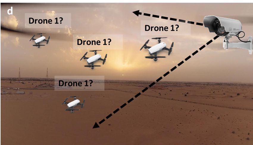
2

the threats posed by drones.                                                                         TABLE I
   Contribution While a SoK in this area has already taken                                      T YPES O F D RONES
place [21], [22], [23], [24], [25], [26], [27], we consider                                       Operating
previous attempts very limited compared to our SoK, because             Category    Weight                      Range       Payload
                                                                                                  Altitude
(1) they either ignore industry methods [21], [22], [23], [24],         Nano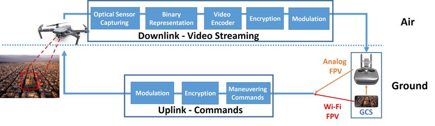
3

Fig. 1. Mini (DJI Matrice 600 Pro), Micro (Parrot   Fig. 2. FPV channel - downlink and uplink.
Bebop 2) and Nano (DJI Tello) drones compared to
the size of a Coca-Cola can.

                            TABLE II                                      manufacturers (DJI, Parrot and Yuneec).
            OSI MODEL OF DJI S PARK (W I -F I FPV DRONE )
                                                                           • Motion Sensors – Accelerometers, gyroscopes, and mag-
                 Layer   7 - Application    Linux                             netometers provide nine dimensions of freedom and are
                 Layer   6 - Presentation
                                            RTP
                                                                              used by the drone for stabilization.
                 Layer   5 - Session                                       • 4K/Full HD Video Camera – Such cameras are used to
                 Layer   4 - Transport      UDP                               capture video and still images.
                 Layer   3 - IP             IPv4
                                                                           • GPS Device – This device is used by the drone for
                 Layer   2 - Data Link      IEEE
                 Layer   1- Physical        802.11n                           localization and automatic navigation.
                                                                           • Barometer – This measuring device is used by the drone
                                                                              to calculate its altitude during flight.
no Internet connectivity. Such drones open a network (access               • Collision Avoidance System – Recent DJI drones are
point) that allows the drone and its controller to communicate.               equipped with vision systems based on monocular cam-
Wi-Fi is by far the most popular method used to include FPV                   eras and ultrasonic sensors in order to sense dangers in the
in budget RC drones (according to [31], [32]), because: (1)                   vicinity of the drone. Skydio [36] uses computer vision
any Android/iOS smartphone (or tablet) on the market can                      algorithms that obtain data from 13 integrated cameras
be used to operate the drone, (2) the only additional hardware                for this task.
required is a Wi-Fi FPV transmitter (which is connected to the
camera of the drone), instead of an additional controller with
                                                                          D. Functionality
a screen that is equipped with a dedicated radio transceiver
which is required by other FPV types (e.g., 2.4/5.8 GHz                      •   Automatic Maneuvering – Allows the operator to mark
analog FPV), (3) drone manufacturers can boost the Wi-Fi                         a target/trajectory via the GCS, around which the drone
FPV drone flight range up to four kilometers (e.g., DJI Spark)                   will automatically maneuver itself according the given
using dedicated hardware, and (4) Wi-Fi FPV drones support                       input, based on its GPS device.
4K resolution. Some drone types are considered pure Wi-Fi                    •   Follow Me – Allows the operator to mark a moving object
FPV drones (e.g., DJI Spark, DJI Phantom 3 SE, Parrot Bebop                      via the GCS monitor, which the drone will automatically
2), and other types of drones contain Wi-Fi FPV along with                       maneuver itself to follow. This functionality is mainly
their dedicated analog FPV (e.g., DJI Mavic pro, DJI Mavic                       used by a drone operator that is on the move and cannot
Air). Almost every FPV-enabled drone selling for less than                       control the drone due to the nature of his/her activity
$100 uses Wi-Fi FPV [31], and there are dozens of kinds                          (e.g., skiing, bicycling, running, etc.); the follow me
of Wi-Fi FPV drones available for purchase [33], [34], [35],                     functionality is based on computer vision algorithms that
ranging from $30 to hundreds and thousands of dollars. Table                     detect the moving object by processing the captured video
II presents the OSI model of the DJI Spark. Analog FPV                           stream.
requires a dedicated GCS for mediation between a drone and                   •   Return to Home (RTH) – Allows automatic maneuvering
a smartphone (that is used as a screen), and therefore drones                    of the drone to a predefined home target and landing
with analog FPV are more expensive than those with Wi-Fi                         based on a GPS device. This method is automatically
FPV. However, analog FPV drones can reach a distance of up                       operated when the connection between the drone and its
to seven kilometers from their GCS (using dedicated amplifiers                   GCS has stopped or been disabled.
and remote controllers), supporting flight ranges of up to eight             •   Smart Capture – Allows the ability to control the drone
kilometers (DJI Matrice 600 Pro).                                                using hand gestures captured by the drone’s camera
                                                                                 during flight. This functionality eliminates the need for
                                                                                 using a GCS and is based on computer vision algorithms
C. Sensors                                                                       that interpret hand gestures and translates them to ma-
  The following sensors can be found in most of the com-                         neuvering commands. This feature is only supported by
mercial drones sold by the three biggest commercial drone                        DJI drones.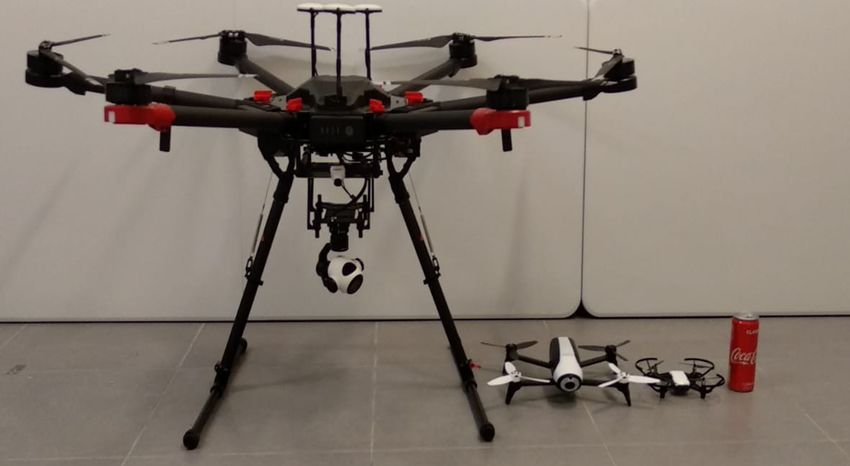
4

                                                                        TABLE III
                                                          C OMPARISON OF TOP COMMERCIAL DRONES
                                      FPV                      Functionality                                             Characteristics
                                                                                          Flight              Flight
                                                 Follow            Automatic     Smart             Speed               Weight    Altitude     Video             Price
 Manufacturer     Name        Wi-Fi     Analog            RTH                             Range               Time                                       Date
                                                  Me               Navigation   Capture            (km/h)               (g)       (km)      Resolution           ($)
                                                                                          (km)                 (m)
                  Matrice
                  600 Pro
                                            !     !        !            !                   5       65       32 -38    9500      2.5-4.5       4K        2016   4999

     DJI
                  Mavic 2
                    Pro
                               !            !     !        !            !         !         8       72         31       907         6          4K        2018   1499
                   Spark       !                  !        !            !         !         2       50         16       300         4         1080p      2017    399
                 Inspire 2                  !     !        !            !                   7       94        23-27    3440       2.5-5        4K        2016   2999
                 Phantom
                   4 Pro
                                            !     !        !            !         !         7       72         30      1388                    4K        2016   1499
                   Mavic
                    Air
                               !            !     !        !            !         !         2       68.4       21       430         5          4K        2018   799
                   Tello       !                                                           0.1      28.8       13        80        0.1         720p      2018   99
                 Bebop 2       !                  !        !            !                   2        64        30       525        0.1        1080p      2017   399
    Parrot
                   Anafi       !                  !        !            !                   4        53        25       312         4           4K       2018   599
                 Mantis Q                   !     !        !            !                  1.5       70        33       479                     4K       2018   499
   Yuneec        Typhoon
                    4K
                                            !     !        !            !                  0.6      30         25       200        0.1         4K        2015   499
                 Typhoon
                  H Plus
                                            !     !        !            !                  1.2      48         30      1995        0.5         4K        2018   1899
   Skydio           R1         !                  !                                        0.1      40         16       997        0.1         4K        2018   1999
   Rabing       Rabing Mini    !                                                           0.1      20         10        90        0.1        720p       2017    70
  HASAKEE           H1         !                                                           0.05     20         7         50       0.05       0.3MP       2018    83
  Holy Stone      HS190                     !                                              0.05     15         7         25       0.05       0.3MP       2017    35
    TOZO           Q2020                    !                                             0.045     12         8         50       0.045        NO        2017    60

E. Uses                                                                                                    III. M ALICIOUS D RONE U SES
                                                                                         The current generation of drones provides FPV capabilities
   Many individual entrepreneurs, small businesses, large com-                        that allow operators to fly drones in areas located up to eight
panies, and local authorities have begun to realize the potential                     kilometers from the operator’s location; this can be done both
of drones and started to adopt drones for various purposes.                           manually and automatically. In addition, modern drones are
Regulations are constantly changing in order to support this                          very small, and they can reach speeds of up to 65 kilometers
revolution, allowing drones to fly over populated areas and                           per hour and carry up to six kilograms. The capabilities that
carry packages [37], [19]. Drone use varies according to                              were identified by industry and encouraged this sector to adopt
the drone’s capabilities. Table III presents a comparison of                          drones for various legitimate purposes [4], [5], [6], [43] have
the capabilities of the top selling Mini, Macro, and Nano                             also been identified by malicious entities that misuse drones
drones. As can be seen from the table, Mini drones (e.g.,                             for illegitimate purposes. The cutting-edge technology and low
DJI Matrice 600 Pro, DJI Inspire 2) can reach a range of                              price of drones made them accessible to individuals, resulting
up to seven kilometers and support flight times of up to 38                           in an increase in drone sales; this has created new threats
minutes. They are also capable of delivering small packages                           and caused the number of drone related incidents to rise
(e.g., DJI Matrice 600 Pro can carry up to seven kilograms).                          significantly in recent years. In this section, we describe the
This type of drone is about to provide an alternative means for                       major threats that drones pose to security and privacy today.
delivering a package and many firms launched pilots around
the world for delivering goods (e.g., Amazon [5], UPS FedEx
[38]), pizza (Dominos [4]), and emergency healthcare (drugs,                          A. Spying and Tracking
blood supply). This type of drones is also used in agriculture                           The FPV channel provides excellent infrastructure for a
(for automatic aerial spraying of liquid pesticides, water, and                       malicious operator to spy on people without being detected
fertilizers [39]) and by militaries [40], [41]. Micro Drones can                      because: (1) it eliminates the need for a malicious operator
reach the same flight’s range as Mini drones, however they are                        to be close to the drone or target by allowing the operator to
very limited in their carrying primarily used for professional                        maneuver the drone from far away to a target that is also far
filming and photography by local authorities (e.g., for disaster                      away from the operator’s location, (2) it can be secured using
management, geographic mapping), law enforcement (e.g.,                               encryption, and (3) it supports HD resolutions that enable the
by police, border patrol officers), professional photographers                        attacker to obtain high quality pictures and close-ups (by using
(e.g., media, film industry), and contractors [42], [43], [44].                       the video camera’s zooming capabilities) that are captured by
The range of Nano drones is limited to 100 meters, and they                           the drone, even when the drone is far from the target POI. In
are considered drones for amateurs. Most of them do not                               addition to the abovementioned, the presence of drones is no
support cutting-edge functionality that is integrated in Mini                         longer restricted in populated areas [19], [37]. Exploiting these
and Micro drones. Some of them do not even contain an                                 facts, drones have increasingly become a threat to individuals’
integrated camera. However, a recent development in this area                         privacy as evidenced by their use to detect a cheating spouse
showed that Nano drones can be used for military purposes                             [7], film random people [8], [9] and celebrities [10], and take
for targeted assassination in a battlefield [45].                                     intimate pictures of neighbors [11]. In addition, empty houses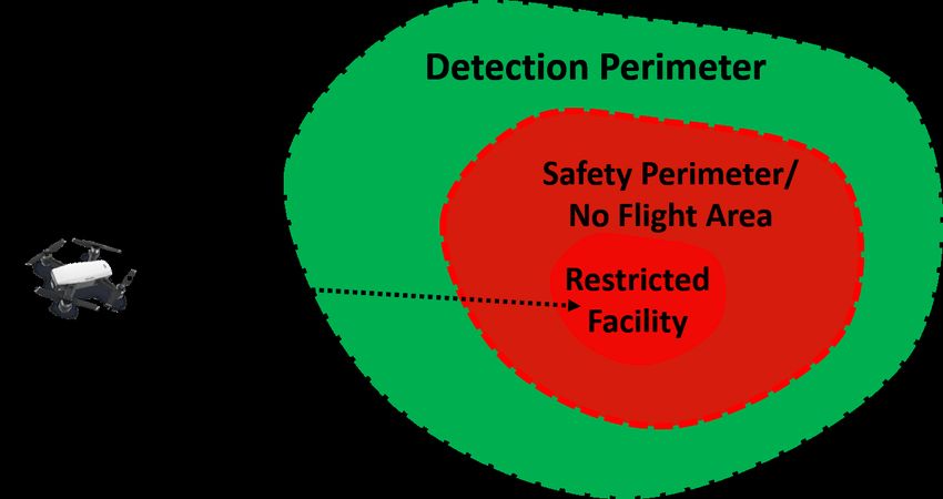
5

                                                                       TABLE IV
                                                          T HREATS M APPED TO T YPES OF D RONES
                                                                               Physical                                                        Cyber
                                      Privacy                                                                       Crime
                                                                               Attacks                                                         Attacks
                         Video               Carrying
                       Streaming     Surveillance Equipment
               Nano       !                                                    Targeted
                                                                          assassination [45]
                                                                                                               Targeting homes
                                                                                                              for burglaries [46]
                                         3D mapping using
                                       radio transceiver [47]
               Micro      !           MITM attacks against
                                      cellular networks [48]
                                                                         Carrying radioactive
                                                                              sand [50]
                                                                                                              Smuggling goods
                                                                                                            into prison yards [12]
                                   Tracking a person according
                                      to his/her devices [49]
                                                                                                               Hijacking radio
               Mini       !                     !                       Carrying a bomb [16];
                                                                 colliding with an airplane [51], [52]
                                                                                                         controlled devices [53], [24]
                                                                                                          Smuggling goods between
                                                                                                                                         Establishing a covert
                                                                                                                                          channel [54], [55]
                                                                                                           countries [13], [14], [15]
               Swarm      !                     !                         Multiple casualty
                                                                           incidents [56]
                                                                                                             Cyber warfare [57]

have also been targeted by burglars for robberies using drones                        lawn of the White House [60] and for landing a ‘radioactive’
[46].                                                                                 drone on the Japanese Prime Minister’s roof [50]. These acts
   Drones can also provide a means of carrying a surveillance                         have raised many questions about the ability to protect a world
device. Several studies have shown that drones equipped                               leader from an aerial targeted assassination.
with radio transceivers can be used for (1) locating and                                 Targeting a world leader is not the only threat that drones
tracking people across a city [49] by extracting unencrypted                          pose. Drones can cause much greater disasters in terms of the
information from the lower layers of the OSI model of                                 number of casualties by exploding into critical infrastructure.
radio protocols (e.g., Wi-Fi and Bluetooth) that reveal the                           This type of threat was demonstrated by the Greenpeace orga-
MAC addresses of their device’s owners (e.g., smartphones,                            nization which crashed a Superman shaped drone into a French
smartwatches) [58], (2) 3D through-wall imaging with drones                           nuclear plant [61]. Multiple casualty incidents resulting from
[47], and (3) performing an MITM attack on telephony [48]                             explosive drones targeting crowds represent another increasing
by downgrading 4G to 2G. Drones can also be used to carry                             concern [62], [63], [64]. This threat has been demonstrated in
traditional spying devices used to eavesdrop on a conversation                        (1) an armed drone attack conducted by unspecified terrorists
(e.g., a laser microphone [59]) and perform keylogging (e.g.,                         against Russian military bases in Syria [56]. Commercial
using a microphone).                                                                  airliners are also vulnerable to exploding and colliding drone
                                                                                      attacks during takeoff and landing [65]. This threat led to the
                                                                                      cancellation of hundreds of flights at Gatwick Airport near
B. Smuggling
                                                                                      London, England, following reports of drone sightings close
   Commercial drones provide optimal infrastructure for smug-                         to the runway [52]. The recent Gatwick incident is probably
gling due to their flight range, size, speed, and carrying ca-                        the most famous drone airport incident due to the volume
pabilities. The abovementioned reasons make drone detection                           of its damage, however there are dozens of reported near
very difficult and have caused criminals to adopt drones for                          miss incidents involving drones all around the world, and
smuggling purposes. Drones are currently used for dropping                            recently such incidents have begun to be reported on weekly
weapons and other contraband into prison yards [12], and                              and monthly base [51].
smuggling goods [14], [15] and drugs between countries
over borders [13]. In terms of smuggling, using a drone has
two major benefits: (1) it eliminates the need for a human                            D. Launching a Cyber Attack
smuggler, and (2) even if a smuggling drone is detected and
caught, determining the identity of its operator (who might be                           Cyber-attacks deemed in the past as infeasible due to
located a few kilometers from the target) remains a challenge.                        distance, line of sight, and other factors can now be performed
                                                                                      using a drone. Two studies [54], [55] showed how to establish
                                                                                      a covert channel for data infiltration [54] and exfiltration [55]
C. Physical Attacks                                                                   to/from an organization. In these studies, the drone was used to
   Exploding and shooting drones are no longer relegated to                           carry a transmitter (in [54]) and a receiver (in [55]), in order to
science fiction. We are now living in an era that was referred                        modulate/demodulate data sent to/from malware installed on
to as “terrorism by joystick” by a few sources [1], [2], [3].                         an air-gapped network of a target organization. Other studies
The reasons that led criminals to adopt drones for smuggling,                         have shown that a drone equipped with a radio transceiver can
have also led terrorists to adopt drones for various purposes.                        be used to hijack a Bluetooth mouse [24] to gain access to
Just recently, the Venezuelan president was the target of an                          a wireless office printer [66]; perform wireless spoofing and
assassination attempt conducted by two drones while speaking                          deauthentication attacks on a targeted user [53]; and hijack
at an event to mark the 81st anniversary of the national                              a Philips Hue smart bulb [57]. Many other known attacks
army [16]. In 2015, two people were arrested in two different                         can also be performed from a drone equipped with proper
incidents for crashing a DJI Phantom into a tree on the south                         hardware, such as speakers (for triggering smart assistants
6
Small and Tactical drones, and many existing mechanisms
for the detection of Small and Tactical drones are ineffective
for detecting Nano, Micro, and Mini drones. A number of
considerations need to be taken into account when evaluating
a detection method. Many factors, including ambient light,
weather, false positive rates, ambient noise, cost, line of sight,
and detection range influence the effectiveness of each method.
In this section, we analyze each method’s effectiveness at
dealing with issues important for securing a restricted area
Fig. 3. Ideal detection scheme for restricted areas. from the presence of drones. Another question that we address
is whether the suggested method can be used for drone
identification (i.e., detecting the drone type).
[67], [68]) and radio transceivers (for exploiting WPA-2 [69] We consider facilities such as airports, jails, and military
and Bluetooth [70] vulnerabilities). bases as restricted facilities. They are considered sensitive
or dangerous due to the nature of the activity performed at
E. Summary & Challenges in the Near Future the facility and the danger posed from physical and cyber-
attacks against them. These kinds of facilities are largely
Table IV maps threats to types of drones. The potential harm
isolated from urban environments and considered no-fly areas
from the abovementioned threats is likely to be amplified in the
for drones. Ideally, drone flights are prohibited from a wider
near future when a malicious operator will be able to operate
perimeter beyond the restricted area; we consider this area a
a swarm of drones simultaneously to perform his/her task,
safety perimeter, however it may vary according to physical
turning a targeted cyber-attack against an organization into
limitations, local aviation authorities, and regulations. A safety
cyber warfare and a targeted assassination into a massive terror
perimeter is required to prevent attackers from spying and
attack. In addition, many sci-fi scenarios that were unrealistic
triggering a cyber-attack against the restricted area. Beyond
due to technological limitations are now real. For example,
the safety perimeter, there is also a detection perimeter in
shooting drones have already been documented [71], and they
which drones are allowed to fly; the area within the detection
can be used by criminals to rob banks [72] and individuals
perimeter must be monitored so that a flying drone that
[73].
enters the safety perimeter is detected early enough. The ideal
detection scheme is presented in Figure 3.
IV. M ALICIOUS D RONE D ETECTION IN R ESTRICTED Commercial drones are programmed to avoid entering a no-
F LIGHT A REAS fly area by automatically landing on the ground or returning to
In this section, we describe methods to detect drones flying a user-defined home coordinate before entering such a zone.
over areas that are restricted to flight. Various geofencing They contain an internal database of no-fly areas defined by
methods used to detect the location of a nearby consumer polygons of GPS coordinates. The functionality that prevents
drone have been introduced in the last few years, and the drones from flying over no-fly areas is extremely important
global anti-drone market size is anticipated to reach $1.85 and prevents operators from accidentally entering a no-fly
billion by 2024 [20]. Geofencing methods are very effective at area, however malicious operators can bypass this functionality
detecting a malicious object in areas that restrict unauthorized using counter mechanisms that are sold online.
entries such as military bases, prisons, etc. These methods
can be used to detect drones that are used for purposes of
dropping weapons and other contraband into prison yards A. Radar
[12], smuggling goods and drugs between countries over Monostatic radar (transmitter and receiver are collocated)
borders [13], and crashing on the White House lawn [60], is a traditional method of drone detection which detects the
[74]). Some geofencing methods have been adopted from electromagnetic waves (EM) reflected from objects in order
prior military knowledge for detecting UAVs and airplanes. to determine a drone’s range, speed, and velocity. However,
However, as indicated by [75], drones are much harder to the detection of the smallest consumer drones requires high-
detect than manned aircraft, so new dedicated methods have frequency radar systems, since drones reflect in a frequency
been suggested to deal with the challenges that arise from of 10Ghz [76], and can evade low-frequency systems [60].
detecting a small, high-speed object flying in the air. The Several studies analyzed monostatic radar (35 GHz [77] and
difficulty in detecting drones is an issue modern armies, police 9.4 GHz [78]) to detect the distance of a nearby drone.
departments, and governments are aiming to overcome, as it is Another study [79] showed that distinguishing between a
a recognized threat to critical infrastructure, operations , and drone and a bird can done using machine learning algorithms,
individuals. by extracting features from micro-Doppler signatures obtained
In this section, we describe dedicated methods used to at a frequency of 9.5 GHz. Several methods suggested the use
detect Nano, Micro, and Mini drones. Small and Tactical of bistatic radar (transmitter and receiver are not collocated) by
drone detection methods are not covered here , because analyzing RF signals in order to detect the presence of a drone.
the challenges associated with detecting Nano, Micro, and A recent study [80] showed how the trail of a DJI Phantom
Mini drones are different than those associated with detecting 4 can be detected from an antenna by analyzing TV signals7
TABLE V
E FFECTIVENESS OF S ENSORS TO VARIOUS E NVIRONMENTAL C ONDITIONS
Sensor’s Effectiveness for Detection
RF Optical Acoustical
Active RF
Factor VIS IR LiDAR
Radar Scanners
Light ! ! ! ! !
Darkness ! ! ! ! !
Noise ! ! ! ! !
Birds ! !
Adverse Weather Conditions
Drone Identification ! ! Limited !
Autonomous Drone Detection ! ! ! !
Multiple Drone Detection ! Only if drones use
different channels
! ! ! Only different
types of drones
Cost ! ! !
Long Range Detection ! ! Require
focusing lens
!
Immunity to NLOS ! !
Locating ! Multiple ! ! ! Multiple
transmitted from an existing TV tower, while another method can be (1) detected with high accuracy (84.9%) from a distance
suggested using multiple antennas to receive and process the of 600 meters, and (2) used to identify the detected drone
orthogonal frequency-division multiplexing (OFDM) echoes type with variable accuracy (64-89%) depending on the drone.
of UAV, which are originally transmitted by the nearby base Another study [98] used USRP to detect drones and found that
stations. Another study suggested the use of a radar [81] the presence of the drone can also be detected in an urban
by triangulating data obtained from three receivers located environment, however it is challenging to observe a drone’s
linearly on a plane, 50 meters from each other (where the RF signature when the drone more than 50 meters away
middle radar is the transceiver), in order to locate drone in without increasing the gain of the receiver’s antenna panel.
space. Two studies [99], [100] used machine learning algorithms to
Radar can be used to detect and locate a drone in space. classify drone transmissions. Another study [101] suggested
However, radar detection can be unreliable, as adverse weather detecting the presence of a drone by analyzing the MAC
conditions affect the reflected wavelength, distorting the wave. addresses of known drones of nearby captured access points .
Radar also fails to identify the drone type and suffers from However, attackers can evade the suggested detection method
high false positive rates, since it cannot distinguish between by changing a drone’s MAC address. RF scanners can be very
birds and drones. In addition, the type of radar that is needed effective at detecting the presence of a drone and identifying
to detect drones is expensive. Due to the abovementioned its type by comparing them to known used bands, however
limitations only 13 out of 33 companies use radar[82], [83], RF scanners suffer from an inability to accurately locate a
[84], [85], [86], [87], [88], [89], [90], [91], [92], [93], [94], drone in space unless they are triangulated [102]. In addition,
and eight of them [82], [85], [87], [88], [89], [90], [91], [94] attackers can evade detection by using drones that transmit on
use radar in the first stage of detection and another type of a dedicated band that is not popular for FPV use.
sensor in the second stage.
C. Optical
B. RF Scanner & Spectrum Analyzer Based on cameras that detect visible frequencies , several
RF scanners and spectrum analyzers are primarily used studies suggested methods to detect a drone and its trajectory
to detect drone radio signatures by detecting bands that are from a single video stream by detecting motion cues [123],
known to be used by drones and other radio signatures. They [124], visual marks [125], and shape descriptors [126]. Other
can be used for (1) classifying a suspicious transmission as studies trained a neural network [127], [128], [129] or used
an FPV channel, and (2) locating a drone in space. One study multiple fixed ground cameras [130] for the same purpose.
analyzed [95] the received signal strength indication (RSSI) While the abovementioned methods can also be used to
patterns of Wi-Fi signals for the detection of approaching, accurately locate and identify (using a preliminary database)
escaping, and spying Wi-Fi drones. This method can be drones, they suffer from false positive detections due to the
applied using a simple Wi-Fi receiver, however it is only similarities between the movements of drones and birds. They
effective when a line of sight between the Wi-Fi receiver and also suffer from high false negative rates due to the increasing
drone exists, and its accuracy for detecting a drone among number of drone models, the use of non-commercial drones,
other moving IoT devices that transmit Wi-Fi signals (e.g., and ambient darkness.
smartwatch, smartphone) was not validated. Another study In order to address the compromised drone detection rate
[96], [97] analyzed 10 seconds of RF signals captured by SDR in dark conditions, several studies suggested using thermal
and found that the RF signatures of commercial Wi-Fi drones cameras that capture invisible wavelengths. A recent study8
TABLE VI
C HARACTERISTICS OF C OMMERCIAL D EVICES FOR D RONE D ETECTION
Radio Optical Acoustic Features
Electro- Detection
RF
Company Name Product Name Radar Camera LiDAR optical Thermal Microphone Range Identification Angle Locating Mobility
Scanner
Camera (KM)
! !
Rogue Drone
3DEO Detection & 2
Mitigation [103]
Aaronia
Drone Detection
System [82]
! ! ! 50 ! ! !
GROK [83] ! 4 ! !
Anti-Drone.eu
Droneshield [104] ! 0.5
Aveillant
Gamekeeper 16U -
Holographic Radar [84]
! 5 !
Black Sage - BST UAVX [85] ! ! ! 0.5 90 ! !
C speed LLC LightWave Radar [86] ! !
CACI SkyTracker [105] ! !
CerbAir DroneWatch [106] ! 1 ! !
Chess Dynamics
Ltd
AUDS [87] ! ! ! 10 180 ! !
DeDrone.com DroneTracker [107] ! ! ! !
DroneWatcher [108] ! 1.6-3.2 ! !
DeTect
HARRIER DSR [88] ! ! ! 3.2 ! !
! !
Digital
Global SigBASE [109]
Systems
DroneShield
FarAlert/WideAlet
Sensors [110]
! ! 1 30 !
Gryphon Sensors Skylight [89] ! ! ! ! 3-10 360 ! !
! ! !
HGH
UAV Detection
Infrared 360
& Tracking [111]
Systems
Kelvin Hughes
Limited
SharpEve SxV
Radar [90]
! ! ! 1.5 360 ! !
MAGNA Drone Detection [112] ! ! ! 0.5-1
Microflown AVISA Skysentry AMMS [113] ! ! 0.4-1 360 !
! ! ! !
Drone Detection
Mistral Solutions and Classification 1
System [114]
ORELIA Drone-Detector [115] ! 0.1 360
Quanergy Systems
Q-Guard -
LiDar X-Drone [116]
! 0.1
Rinicom SKY PATRIOT [117] ! ! ! 0.8 !
Rinicom and
METIS Aerospace
SKYPERION [118] ! !
! ! ! !
ROBIN
Radar ELVIRA [91]
Systems
Rohde and
Schwarz
R&S
ARDRONIS-I [119]
! 1-2 !
SAAB Group
Giraffe AMB
Radar - ELSS [92]
! 30-470 360 ! !
Sensofusion AIRFENCE [120] ! !
SpotterRF
A2000 Radar
UAVX [93]
! 0.2-1 45/90 ! !
Squarehead
Technology
DiscovAir [121] !
TCI
International
BlackBird [122] ! !
Thales SQUIRE [94] ! ! 48 ! !
[131] suggested using short-wave infrared (SWIR) for night using a LiDAR sensor and found that (1) commercial drone
detection. Another study [132] performed a comparison of speed does not affect the accuracy of detection, and (2) drones
drone detection at various distances using short-wave infrared can be detected from a distance of a few hundred meters. The
(SWIR), mid-wave infrared (MWIR), and long-wave infrared greatest disadvantage associated with using an infrared camera
(LWIR) imagers and found that (1) SWIR imagers do not and LiDAR is their inability to identify a drone due to the low
appear to be good candidates for drone detection due to their resolution of captured images.
reliance on external light sources, sensitivity to the SWIR Typically, cameras that capture visible and invisible wave-
absorbing materials used on UAS, and frequent capturing of lengths are combined to support detection throughout the day
fast moving and bright insects; (2) LWIR imaging may be best and night. In addition, 16 companies [103], [82], [85], [87],
suited for the detection and assessment of drones, however [107], [88], [110], [89], [111], [90], [112], [114], [116], [117],
nuisance sources such as birds will also be captured in the [91], [94] out of 33 companies use at least a single optical
LWIR, and certain angles above the horizon may present sensor to detect drones, including electro-optical sensors which
challenges due to the temperature equivalence of the target have not been suggested in academic studies for the use of
and the background; and (3) MWIR may offer better clutter identifying the range of a detected drone. However, both cap-
rejection, while still relying upon self-emitted photons from turing visible and invisible optical sensors (1) are dependent
targets. A recent study [133] analyzed the detection of drones on the line of sight, (2) require excellent focus capabilities to9
detect drones located far from the camera, (3) require multiple more than a single sensor is the approach taken by 16 of 33
cameras or a 360 camera to provide full 360 degree detection, companies for drone detection, however the main disadvantage
and (4) are not immune to adverse weather conditions. of the multiple sensor approach is the total cost of applying
the method.
D. Acoustic
Acoustic detection methods are not dependent on the line of F. Other Methods
sight or the size of the target UAV , and many studies have sug- Other novel methods have been suggested for drone de-
gested the use of a microphone array to detect drones by ana- tection. In [149], the authors suggested using "humans and
lyzing the noise of the rotors. Other studies presented methods sensors" in order to create a collaborative network for de-
used to detect drones based on comparing a drone’s captured tecting drones. Their approach relies on people who use their
acoustic signature with other signatures stored in a database smartphones to capture photos of detected drones and send this
of previously collected sound signatures. A recent study [134] information to a centralized server. However, this approach is
compared a drone’s FFT signal obtained from a microphone not practical for real use cases.
using machine learning techniques, while other research [135]
used correlation for comparison. Acoustic signature collection
G. Drone Detection Industry
is a major issue for acoustic detection , however factors such
as wind, temperature, time of day, obstacles, and other sounds Table VI provides a comparison of the 33 largest drone
can bend the sound waves, changing the direction the sound detection companies [24] that sell commercial devices for
will travel ([136]). The collection of a sound signal on a hot drone detection, comparing them based on the sensors they use
day with little wind on an open plain will be significantly and the features they support according to their specifications.
different than collection of the signal on a cold, windy night As can be seen, 24 companies stick with traditional radio
in a forest [136], [137]. Several studies suggested methods methods (using radar or a RF scanner), 16 companies use
that triangulate sound obtained from centralized [138] and some type of optical sensor, and only eight companies use
distributed [139] microphone arrays in order to detect a drone’s acoustic methods. Eighteen companies use multiple sensors
direction of arrival and location. Another study [140] sug- as a means of detection . Only nine companies use sensors to
gested a two-layer feature extractor that can be used to detect identify detected drones. We made the following interesting
drones. While acoustic methods can be used to identify a drone observations regarding drone detection mechanisms:
and locate its presence (using multiple distributed microphones • Asymmetric costs - Some of these technologies are sold
), relying on acoustic signature methods for drone detection for millions of dollars [150] and are used to detect drones
suffers from false negative detections due to the increasing that can be purchased for hundreds of dollars. In addition,
number of drone models and false positive detections due to the financial damage that can be caused by a drone that
ambient noise. In addition, these methods are very limited in costs a few hundreds of dollars is greater (by several
their ability to detect a drone from a distance and require the orders of magnitude) than the price of a drone, as was
application of noise filtering techniques and calibration for demonstrated in the Gatwick Airport drone incident [52]
different environments [141]. The abovementioned limitations that affected about 140,000 passengers and over 1,000
are likely the reason that microphones are only used by eight flights and other incidents.
out of 33 companies for drone detection. • Different use cases require different solutions - Factors
like detection range and mobility are most likely to
E. Hybrid determine the chosen solution.
• Variety of sizes - Some detection mechanisms are the
Table V presents an analysis of sensors’ ability to meet size of a suitcase, while others are much larger (half the
drone detection system requirements. As can be seen, there size of a car) and require a number of operators.
is no sensor capable of fulfilling all of the requirements, • Modular products - Their systems can work based on a
confirming the findings of [142], [143]. In order to overcome single sensor but also support adding additional sensors.
the limitations that arise from using a single sensor, many
However, as was proven in many cases, detecting a drone is
sensor fusion methods have been suggested. Several methods
a major challenge, even for commercial drones whose radio,
[144], [145], [146] pproposed combining acoustic and optical
acoustic, and visual signatures are published or can be learned.
methods, using (1) an acoustic camera, or (2) a camera with
An attacker that would like to exploit this fact to evade drone
a microphone array. While in [144], [145] an optical sensor
detection mechanisms may try to use a drone with a different
was used along with an acoustic sensor, in [146] a moving
signature by building his/her own drone or changing a drone’s
optical sensor was positioned in the center of the secured area,
signatures (visual and radio).
and several microphones were located outside of the area to
provide two stages of detection: direction of arrival (using
a microphone) and location (using a camera). Other studies V. M ALICIOUS D RONE D ETECTION IN N ON -R ESTRICTED
suggested combining optical and RF methods such as LiDAR F LIGHT A REAS
and radar [78]. Other research proposed the use of all three In no-flight zones, a drone is considered dangerous/mali-
methods (acoustic, optical, and RF) in order to detect and cious based its location, so systems that are aimed at detecting
locate a drone in space [147], [142], [148]. In general, using and locating a drone (e.g., radar, LiDAR, etc.) can provide10
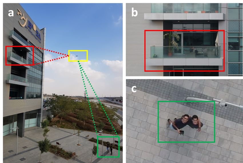
Fig. 4. Spying classification problem - legitimate and illegitimate use of a drone from the same location: (a) a drone boxed in yellow, two people boxed in
green, and the window of an organization boxed in red, (b) illegitimate use of the drone camera to film the organization, (c) legitimate use of the drone for
selfie purposes. Identification problem - when all drones look identical (d), it is difficult to match virtual IDs to physical drones in the camera view.
a solution. However, detecting a malicious drone in non- conducted by an operator that is located far from the target
restricted areas remains a challenge [151], [152]. Many coun- (e.g., one kilometer) consists of three unique flying episodes
tries around the world allow drones to fly in populated/urban : approaching the target, spying on the target, and escaping
areas [19], [37] as part of a new "open skies" policy. This from the target. Based on this observation, they suggested
policy has encouraged an increasing number of organizations detecting the correlative radio patterns from a static radio
to adopt drones for various legitimate purposes. Drones are receiver by analyzing the RSSI of its FPV channel. However,
currently used for pizza delivery [4], the shipment of goods as was indicated in a recent study from S&P 2019 [153], this
[5], filming [6], and many other legitimate purposes [43]. approach cannot be used to detect whether a specific POI is
Allowing drones to fly in populated areas has created two being filmed, as demonstrated in Figure 4a.
main challenges : purpose detection problem and identification In order to detect whether a specific POI is being filmed,
problem. Given that we are living in an era in which drones a recent study from S&P 2019 suggested a cryptanalysis
are flying among us, we argue that there is major scientific approach [151], [152]. The authors found that they could
gap in the area of malicious drone detection in non-restricted influence the number of transmitted packets being sent from
flight areas, particularly in light of the challenges that have a Wi-Fi FPV drone (e.g., DJI Spark, Parrot Bebop 2, Parrot
arisen as a result of the increased use and freedom of drones. Anafi, etc.) over its FPV channel by using an LED flicker
and exploiting the drone’s video compression process. They
A. Purpose Detection Problem showed that with each on/off change of a flicker at a given
frequency, a larger amount of data is sent over the FPV
The greatest challenge stemming from allowing drones to
channel, causing a watermark to be added to the FPV channel
fly in populated areas is detecting the drone’s purpose. This
that can be detected by analyzing the frequency [153] and time
problem has significant impact in several areas, the best-known
[151] domains via a network interface card possessed by static
of which is privacy: drones are being used by their operators to 1
and moving targets 2 .
conduct privacy invasion attacks, in which they spy on people
and other targets [7], [8], [9], [10], [11]. However, currently the suggested cryptanalysis approach
More specifically, given a drone that is passing near a is limited to Wi-Fi FPV drones and can be bypassed by
house,how can we tell whether the drone is being used for eliminating the video compression stage or by using two video
a legitimate purpose (e.g., delivering pizza) or an illegiti- cameras. Currently, no other methods have been suggested
mate purpose (e.g., taking a peek at a person showering to determine whether a passing drone is being used for a
in his/her own house)? The use of traditional geofencing legitimate/illegitimate purpose, and as mentioned earlier, there
methods (e.g., radar, LiDAR) as a means of detecting a is a major scientific gap in this area.
privacy invasion attack in non-restricted areas (e.g., residential
neighborhoods) will fail to distinguish between the legitimate B. Identification Problem
use of a nearby drone and illegitimate use that invades an The second problem created by allowing drones to fly in
individual’s privacy. This distinction can only be made based populated areas is referred to as the identification problem
on the orientation of the drone’s video camera rather than [154]. Identifying a drone, i.e., determining the association
on the drone’s location; more specifically, differentiation be- between drones’ physical IDs (such as the drone’s MAC
tween illegitimate and legitimate use of a drone can only be address) and visual IDs (such as object tracker output) is
accomplished by determining the exact POI (point of interest) an unresolved issue with major impact. For example, given
being streamed over the video channel and not according to several drones hovering near each other that were captured
the drone’s location, as demonstrated in Figure 4. by a video camera and radio receiver (e.g., radar, spectrum
A recent study from NDSS 2017 [95] suggested a method
for detecting a privacy invasion attack based on a drone’s 1 https://youtu.be/4icQwducz68
flight behavior. They observed that a privacy invasion attack 2 https://youtu.be/9PVaDpMsyQE11
analyzer), hhow can we distinguish between a foe drone • Violating confidentiality - The attacker can determine
(used to carry a bomb or to spy) and a friend drone whether a specific point of interest is being video
(used by a farmer to fertilize its corps) in cases which streamed by the drone.
both drones are identical? Even if the detected drones use In addition, we also review countermeasures methods against
a radio-based authentication protocol (e.g., transmitting their the attacks.
MAC IDs) to identify themselves, we cannot determine a foe
from a friend. This problem is illustrated in Figure 4d. A. Protocol-Based Attacks & Countermeasures
Existing "friend or foe" [155] identification methods are
widely used by militaries to authenticate their airplanes in In this subsection, we review attacks that exploit protocol
order to detect a rival airplane, however, as can be seen in vulnerabilities. Older drone generations that were manufac-
Figure 4 [154], these methods are not effective for drones due tured by Parrot were based on Wi-Fi FPV that did not
to the fact that a friend and a foe drone can be located too near require any authentication to join the network (open access
to each other at the same altitude and GPS location. Therefore, points). Several studies [21], [157], [159] applied traditional
even if the GPS location of a friend is known, it cannot be used methods against open access points and presented two DOS
to distinguish between friend and foe drones that are located attacks against these drones by (1) applying a deauthentication
a few centimeters from each other given the known average attack [157], [158], and (2) flooding the drone’s NIC [159].
4.5 meter GPS error under open skies [156]. A recent study Performing a hijacking attack after the deauthentication attack
[154] suggested a way of identifying each drone by matching stage was also suggested by [157]. Another study [158] found
the motion detected through their inertial sensors and from that the FTP folder that stores images and videos captured by
an external camera . However, this method requires additional Parrot drones does not require any authentication and deleted
hardware that can obtain data from sensors and broadcast it to files from the FTP folder. However, the abovementioned
a drone detection mechanism using a transmitter. This method methods can only be applied to older Parrot drones models
can be effective for military purposes [154], however it cannot as new Parrot drones support WPA-2 with authentication;
be used to authenticate/identify most commercial drones, since therefore, as long as the joining password has not been leaked,
they do not support broadcasting their sensors’ data, and out- the abovementioned attacks cannot be applied on newer Parrot
of-band solutions to authenticate drones remain a gap. drones. Two studies demonstrated methods for hijacking a
The scientific gap in this area can be exploited for various drone using a replay attack that was applied from a malicious
purposes by malicious entities, particularly in areas in which GCS against weak uplinks of FPV channels (Figure 2). A
drone flight is permitted. Due to the inability to distinguish novel study [160] presented techniques used to hijack a $30k
between a friend and foe, in the domain of physical attacks, drone used by police departments by exploiting the XBee
for example, terrorists can fly a drone equipped with a bomb 868LP protocol using replaying maneuvering commands that
in order to assassinate world leaders [16] or launch a multiple are sent over 868 MHz from the GCD to the drone. Another
casualty incident [62], [63]. Other domains, including smug- study [161] showed that amateur drones whose uplinks are
gling and cyber-attacks, are also affected by this scientific gap. based on the MAVLink protocol and can be found on amateur
Considering the fact that drones do not support the func- drones (e.g., 3DR IRIS+, Erle-Copter) can also be hijacked
tionality to authenticate and identify themselves, the ability using a replay attack. However, a recent [162] study showed
to detect smuggling attempts and cyber-attack remains a that malicious replay attacks can be detected by authenticating
challenge [54], [55]. Given a drone that is being used to the drone’s operator via measurements obtained from motion
launch a cyber-attack, how can we identify this drone if sensors using machine learning algorithms.
its operator disguised the drone as an aerial pizza delivery
drone? We demonstrate a new type of cyber warfare against B. Sensor-Based Attacks & Countermeasures
smart cities that triggers watering via a cellular smart irrigation As described in Section II, drones contain motion sensors,
system while disguised as a Domino’s Pizza delivery drone. obstacle avoidance sensors, cameras, and many other sensors
In addition, some organizations deploy drones on their that are important for real-time maneuvering. In this subsec-
premises in order to transport packages between buildings that tion, we review sensor-based attacks, which are also known as
are located some distance from one other. This can easily be spoofing attacks. The MEMS gyroscope and accelerometers
exploited by attackers to spy on the organization without being are sensitive to ultrasound at their resonance frequency, and
detected using the same type of drone that is used by the attacks targeting this vulnerability have been demonstrated in
organization. many studies [176], [177] and was demonstrated in an article
from USENIX 2015 by [168] where the authors spoofed a
VI. ATTACKS AGAINST D RONES & C OUNTERMEASURES drone’s gyroscope output to maximum values, forcing the
In this section, we review methods used to attack drones. drone to land. However, this type of attack requires pow-
Attacks against drones can result in the following: erful speakers and is very limited in its range, since sound
• Hijacking - The attacker gains complete control of the deteriorates with distance. A recent paper from CCS 2018
drone. [169] proposed a software solution for the acoustic attack
• Denial-of-Service - The attacker causes the drone to that was presented at USENIX 2015 [168]. The authors
one of the following results: crashing, landing, drifting, implemented a software-based solution for control invariant
disabling the operator the video link. checking and demonstrated that sensor spoofing attacks that12
TABLE VII
A NTI D RONE METHODS C OMPARISON
Methods Effectiveness Results & Countermeasures
Wi-Fi FPV Proprietary FPV LOS Denial of Aerial Violating
Type Countermeasure
Drones Drone Independent Service Hijacking Confidentiality
Deauthentication [157], [158] ! ! ! !
Flooding NIC [159] ! ! ! Using WPA
Protocol Deleting Stored
Videos [158]
! !
Replay
Attacks [160], [161]
! ! ! Operator’s
Authentication [162]
Detecting Captured
POI [151]
! ! Disabling Video
Compression
Camera [163] ! ! Shifting
Spoofing
Sensors
GPS
[164], [165], [158]
! ! ! Force
Landing
During RTH
Mission
Anti GPS
Spoofing [166], [167]
Motion
Sensors [168]
! ! ! Landing
Software Based
Solution [169]
Magnometer [158] ! ! ! Force
Calibration
Compromised
Fake
Propeller [170]
! ! ! Crashing
Parachute
[171], [172], [173]
! ! !
Component
Compromised Using a Control Flow
Firmware [174], [164] Backdoor Approach [175]
Jammers
GPS [158] ! ! ! Drifting, Loss
of Control
FPV Channel [164] ! ! ! Disabling
FPV
Nets ! ! Landing,
Crashing
Physical
Attacks
Bullets ! ! Crashing
Parachute
[171], [172], [173]
Lasers ! ! Crashing Mirrors, Smoke
Missiles ! ! Crashing
Predator Birds ! ! Landing
result in anomalous measurements obtained from a drone’s chain attack or via the Internet by compromising a drone’s
sensors can be detected by comparing a measurement that was Internet connected GCD (e.g., a smartphone) with malware or
obtained from a sensor to a measurement that was predicted a fake application. A recent study [175] suggested a control
by their framework. Another study [163] demonstrated a flow integrity approach to detect attacks against software. They
method of hijacking a drone by spoofing its downward camera implemented their approach on the ArduPilot OS and showed
and influencing the stabilizing algorithm (which is based on that it was capable of detecting attacks such as buffer overflow
detecting movement changes from a video stream) by directing attacks and illegal executions of functions.
a laser and projector to the surface of a flying drone. A few
studies [164], [165], [158], [178], [179] presented a method D. Jammers
for hijacking and disabling a drone using GPS spoofing (1) of
no-fly zones, (2) during autonomous navigation to a target. In Several studies have suggested disrupting incoming/outgo-
order to detect GPS spoofing attacks, various software [166], ing communication using jammers. One study showed that
[167] and hardware-based solutions for drones were adopted applying GPS jamming [158] to drones results in drifting and
from prior knowledge that exists in this area . Another study difficulty controlling the drone, and prevents the return to
[158] found that the presence of a magnetic field near the home functionality from working. Another study applied radio
DJI Phantom 3 always necessitated recalibration of the drone’s jamming [164] against a video link channel and showed that
compass prior to takeoff. the FPV functionality was disabled in the GCD , preventing the
operator from maneuvering the drone with no LOS. Jammers
are one of the most commonly used products for disabling a
C. Compromised Component & Countermeasures
drone on the market. Some commercial anti-drone jammers
Recently, a new type of attack targeted at drones was are directional RF transmitters in the form of mobile shooting
suggested by [170], [174], [164] based on compromising guns that apply jamming to GPS signals and ISM bands known
their hardware/software. A recent study [170] demonstrated a to be used by drones [180], [181], [182], [183], [184], [185],
supply chain attack against drone hardware using a propeller [186]. Other jammers are stationary devices [187], [188],
that is visually identical to a genuine propeller but crashes [189], [190]. A jammer’s ability relies on the strength of its
the drone upon takeoff. Two other studies suggested attacks radio transmitter, however the best jammer on the market is
against drone software. In [174], the researcher installed effective at ranges of up to two kilometers.
malware on a drone’s firmware and used it to open a backdoor.
In [164], the researcher reverse engineered DJI’s SDK and
escalated its permissions in order to create a C&C application E. Physical Attacks & Countermeasures
for smartphones which is used to control the drone. Compro- A physical attack is the most common means of disabling
mising a drone’s software can be accomplished with a supply drones used by the industrial sector. Several companies utilize13
nets to disable and crash drones. Such nets are connected to B. Suggestions for Dealing with Cyber-Attacks on Drones
drones that swoop and swag malicious drones or fire a shot While detecting a cyber-attack against drones is difficult,
from the air (using another drone) [191], [192], [193], [194], trying to deal with the repercussions of cyber-attacks is much
[195], or the ground (using a gun) [196], [197], [198], [199]. harder. For example, even if a sensor-based attack has been
The net stops the propellers from turning and causes the drone detected, securing the drone or returning it home safely is
to fall and crash to the ground. One company [200] sells a complex problem if the drone’s system cannot rely on
predator birds (eagles and falcons) that have been trained to the measurements from the integrated sensors (e.g., GPS,
detect, capture, and land drones. Other companies sell vehicles gyroscope). In order to deal with this problem, we hypothesize
equipped with laser guns and cannons that irradiate a directed how accurate will be a software-based mechanism that stores
high energy laser beam that causes a drone to burn in the the history of the series of maneuvering commands (from the
air and fall to the ground [201], [202]. We also note that an time the drone has takeoff until a sensor-based attack has been
army has used a $3 million Patriot missile to shoot down identified, e.g., using the technique suggest by [169]). When an
a drone [203]. Since physical attacks can cause the drone attack (e.g., a hybrid GPS spoofing and FPV jamming attack)
to crash and in so doing harm people (in populated areas that prevents the drone from flying according to the commands
that allow drone flight) and cause damage to facilities and sent from its operator (due to FPV jamming) and automatically
the drone itself, several companies sell a dedicated parachute returning home (due to GPS spoofing) has been detected, the
for drones (e.g., DJI Inspire 1 and 2, DJI Phantom 2-4, DJI drone can return to its takeoff location by traversing its series
Matrice) [171], [172], [173]. Some of the parachutes contain of maneuvering commands from the last command (when
an automatic trigger system that is designed to open the the attack was identified) to the first command (takeoff) and
parachute if the drone falls , while others are manually opened performing the opposite of each of the commands.
by the drone operator (based on the RF controller). Some
parachutes activate an audio buzzer to warn bystanders to
move out of harm’s way. C. Suggestions for Determining a Drone’s Intention
Other mechanisms for detecting the purpose of a drone
VII. F UTURE R ESEARCH D IRECTIONS based on its flight behavior must also be introduced. For
In this section, we suggest future research directions in areas example, we hypothesize whether the cellular hijacking that
in which a scientific gap exists. We include suggestions that was demonstrated in our video can be detected by analyzing
can be applied in order to detect attacks caused by malicious the radio activity of known cellular bands using a spectrum
operators who will not follow regulations and laws. analyzer and intersecting the origin of the cellular transmitter
with the location of a detected drone.
A. Suggestions for Authenticating Drones and Operators
Methods for authenticating drones based on a white-listing D. Open Questions
approach must be introduced in order to solve the identification
One important question that requires a solution is how to
problem (i.e., detecting a specific drone among similar drones).
detect and locate the operator of a malicious drone given the
For example, one interesting method that can be used for this
fact that such malicious operators will not follow regulations,
purpose as an out-of-band solution is installing a microcon-
such as installing a form of identification on a drone or
troller on a group of white-listed drones. In this case, the
registering its unique identifier in a national database, even
microcontroller will serve as a transmitter for authenticating
if such regulations are instituted. In addition, we hypothesize
the drone by modulating an RSA token using visual cues (e.g.,
whether there is a method for creating a unique signature for
using an LED strip); the visual cues will be captured by a
each drone that cannot be changed or copied (for example, a
video camera connected to a computer that will analyze the
dedicated acoustic signature resulting from the manufacturing
frames in the video stream and interpret the series of visual
process of a drone’s rotor).
modulations to an RSA token . Based on the result, it will
decide to authenticate the drone or not. We also hypothesize
whether drone operators can be authenticated based on their R EFERENCES
flying skills captured via a third party static radio receiver [1] P. Gazette, “Terrorism by joystick,” http://www.post-gazette.com/
by analyzing a drone’s radio emissions. While authenticating opinion/2018/08/07/Terrorism-by-joystick/stories/201808070022.
[2] W. Post, “Drone attacks are essentially terrorism by joystick,” https:
a drone operator has already been suggested using an on //www.washingtonpost.com/opinions/drone-attacks-are-essentially-
board approach (which we do not consider a third party terrorism-by-joystick/2018/08/05/f93ec18a-98d5-11e8-843b-
approach), we propose using the method introduced in [204] 36e177f3081c_story.html?noredirect=on&utm_term=.faccb2a27e26.
[3] S. C. M. Post, “Analysis: with drone attacks, the era of joystick
for authenticating smartphone users in indoor environments terrorism appears to have arrived,” https://www.scmp.com/news/
via a laptop’s network interface card by analyzing the channel world/article/2158380/analysis-drone-attacks-prove-era-joystick-
state information of the Wi-Fi protocol . are based on replay terrorism-has-arrived-and-world.
[4] Newsweek, “Pizza delivery by drone launched by domino’s,” http://
attacks by analyzing the received signal strength indication www.newsweek.com/pizza-delivery-drone-dominos-493371.
(RSSI) of a radio command that was sent from another GCS [5] B. Insider, “Amazon and ups are betting big on drone de-
(i.e., if the difference in the received signal strength indication livery,” http://www.businessinsider.com/amazon-and-ups-are-betting-
big-on-drone-delivery-2018-3.
between two consecutive commands is over a predefined [6] Fortune, “Cnn just got approved to fly drones over crowds of people,”
threshold, the received command will be ignored). http://fortune.com/2017/10/18/cnn-drones-faa-crowds/, 2017.You can also read