SOUTH AUGUSTINE ISLAND NONCOMPETITIVE GEOTHERMAL PROSPECTING PERMIT - Preliminary Written Finding of the Director
←
→
Page content transcription
If your browser does not render page correctly, please read the page content below
April 28, 2022

SOUTH AUGUSTINE ISLAND
NONCOMPETITIVE
GEOTHERMAL
PROSPECTING PERMIT

Preliminary Written Finding of the Director
Recommended citation:

DNR (Alaska Department of Natural Resources). 2022. South Augustine Island Noncompetitive
      Geothermal Prosecting Permit Preliminary Written Finding of the Director. April 28, 2022.

Questions or comments about this written finding should be directed to:

Alaska Department of Natural Resources
Division of Oil and Gas
550 W. 7th Ave., Suite 1100
Anchorage, AK 99501-3560
Phone 907-269-8800

The Alaska Department of Natural Resources (DNR) administers all programs and activities free from
discrimination based on race, color, national origin, age, sex, religion, marital status, pregnancy,
parenthood, or disability. The department administers all programs and activities in compliance with Title
VI of the Civil Rights Act of 1964, Section 504 of the Rehabilitation Act of 1973, Title II of the
Americans with Disabilities Act (ADA) of 1990, the Age Discrimination Act of 1975, and Title IX of the
Education Amendments of 1972.

If you believe you have been discriminated against in any program, activity, or facility please write
to:

        Alaska Department of Natural Resources ADA Coordinator
        P.O. Box 111000
        Juneau AK 99811-1000

The department’s ADA Coordinator can be reached via phone at the following numbers:

        (VOICE) 907-465-2400,
        (Statewide Telecommunication Device for the Deaf) 1-800-770-8973, or
        (FAX) 907-465-3886

For information on alternative formats and questions on this publication, please contact:

        DNR, Division of Oil and Gas
        550 W. 7th Ave., Suite 1100
        Anchorage, AK 99501-3560
        Phone 907-269-8800.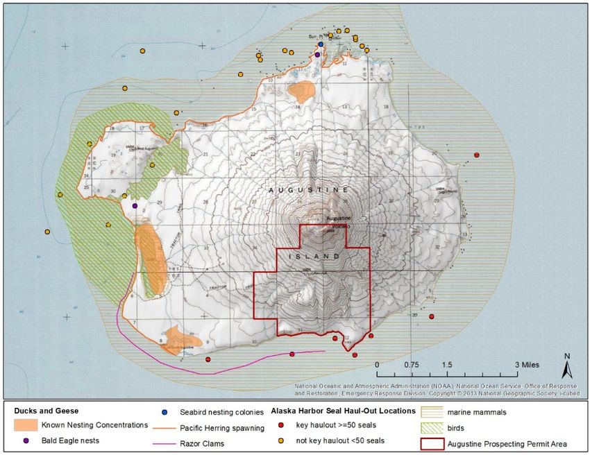
SOUTH AUGUSTINE ISLAND
           NONCOMPETITIVE
              GEOTHERMAL
        PROSPECTING PERMIT

Preliminary Written Finding of the Director

                                       Prepared by:
             Alaska Department of Natural Resources
                            Division of Oil and Gas

                                     April 28, 2022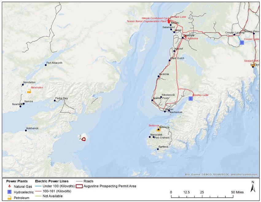
Contents
                                                                                                                                            Page
Chapter One: Director’s Preliminary Written Finding and Decision                                                                                  1-1
  A. Procedural Background ......................................................................................................... 1-1
  B. Statement of Applicable Law................................................................................................. 1-1
  C. Analysis Summary ................................................................................................................. 1-2
     1. Area Description................................................................................................................. 1-2
     2. Reasonably Foreseeable, Cumulative Effects .................................................................... 1-2
  D. Preliminary Decision and Request for Public Comments ..................................................... 1-5
Chapter Two: Authority and Scope of Review                                                                                                        2-1
  A. Authority................................................................................................................................ 2-1
  B. Scope of Review .................................................................................................................... 2-1
     1. Reasonably Foreseeable Effects ......................................................................................... 2-2
     2. Matters Considered and Discussed..................................................................................... 2-2
     3. Review by Phase ................................................................................................................ 2-3
  C. Appeal .................................................................................................................................... 2-4
Chapter Three: Description of the Disposal Area                                                                                                   3-1
  A. Property Description .............................................................................................................. 3-1
  B. Cultural and Historical Background and Resources .............................................................. 3-2
  C. Geologic Hazards ................................................................................................................... 3-2
     1. Volcanic Ash Clouds, Ash Fallout and Volcanic Bombs................................................... 3-2
     2. Pyroclastic Flows, Landslides, and Debris Avalanches ..................................................... 3-3
     3. Tsunamis ............................................................................................................................ 3-3
     4. Earthquakes and Induced Seismicity .................................................................................. 3-4
     5. Directed Blasts and Lava Flow .......................................................................................... 3-4
     6. Lahars and Floods .............................................................................................................. 3-5
     7. Volcanic Gases ................................................................................................................... 3-5
     8. Geohazards Related to Geothermal Resource Activities and Subsidence.......................... 3-5
  D. Mitigation Measures .............................................................................................................. 3-6
  E. References .............................................................................................................................. 3-6
Chapter Four: Habitat, Fish, and Wildlife                                                                                                         4-1
  A. Key Habitats of the Disposal Area ........................................................................................ 4-1
     1. Terrestrial Habitats ............................................................................................................. 4-1
     2. Coastal and Marine Habitats .............................................................................................. 4-2
     3. Designated Habitats............................................................................................................ 4-3
  B. Fish and Wildlife Populations................................................................................................ 4-5
     1. Fish and Shellfish ............................................................................................................... 4-5
     2. Birds ................................................................................................................................... 4-7
     3. Mammals .......................................................................................................................... 4-11
  C. References............................................................................................................................ 4-12
Chapter Five: Current Uses of the South Augustine Island Area                                                                                     5-1
  A. Research and Education......................................................................................................... 5-1
  B. Fish and Wildlife Uses and Value ......................................................................................... 5-2
     1. Commercial Fishing ........................................................................................................... 5-3
     2. Sport Fishing ...................................................................................................................... 5-5
  C. Recreation and Tourism ......................................................................................................... 5-7
  D. Energy and Infrastructure ...................................................................................................... 5-8

                              South Augustine Island Noncompetitive Geothermal Prospecting Permit
                                                                               i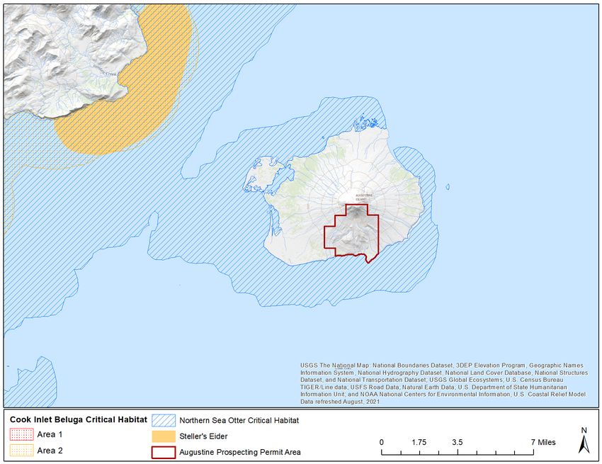
E. References .............................................................................................................................. 5-8
Chapter Six: Geothermal Resources in the Prospecting Permit Area                                                                                6-1
  A. Geology ................................................................................................................................. 6-1
  B. Geothermal Energy Potential ................................................................................................. 6-1
  C. Geothermal Development Activities...................................................................................... 6-2
     1. Geological and Geophysical Surveys ................................................................................. 6-2
     2. Well Drilling ...................................................................................................................... 6-3
     3. Facility Construction and Operation .................................................................................. 6-4
  D. Transmission of Geothermal Power ...................................................................................... 6-6
  E. References .............................................................................................................................. 6-6
Chapter Seven: Governmental Powers to Regulate Geothermal Exploration and
    Development Activities                                                                                                                      7-1
Chapter Eight: Reasonably Foreseeable Cumulative Effects of Geothermal Exploration
    and Subsequent Activities                                                                                                                   8-1
  A. Reasonably Foreseeable Cumulative Effects on Air ............................................................. 8-1
     1. Potential Cumulative Effects on Air Quality...................................................................... 8-2
     2. Mitigation Measures ........................................................................................................... 8-5
  B. Reasonably Foreseeable Cumulative Effects on Water ......................................................... 8-5
     1. Potential Effects on Water Quantity and Quality ............................................................... 8-5
     2. Mitigation Measures ........................................................................................................... 8-7
  C. Reasonably Foreseeable Cumulative Effects on Habitats and Fish and Wildlife
      Populations ............................................................................................................................ 8-7
     1. Potential Effects on Habitats .............................................................................................. 8-8
     2. Potential Effects on Fish and Shellfish............................................................................... 8-9
     3. Potential Effects on Wildlife ............................................................................................ 8-10
     4. Mitigation Measures ......................................................................................................... 8-13
  D. Reasonably Foreseeable Cumulative Effects on Fish and Wildlife Uses ............................ 8-14
     1. Potential Effects on Commercial and Sport Fishing ........................................................ 8-14
     2. Potential Effects on Subsistence....................................................................................... 8-15
     3. Mitigation Measures ......................................................................................................... 8-15
  E. Reasonably Foreseeable Cumulative Effects on Historic and Cultural Resources .............. 8-15
     1. Potential Effects on Historic and Cultural Resources ...................................................... 8-15
     2. Mitigation Measures ......................................................................................................... 8-16
  F. Reasonably Foreseeable Fiscal and Other Effects on the State and Communities............... 8-16
     1. Potential Effects on the State and Communities .............................................................. 8-16
     2. Mitigation Measures ......................................................................................................... 8-17
  G. References ........................................................................................................................... 8-17
Chapter Nine: Mitigation Measures                                                                                                               9-1
  A. Mitigation Measures .............................................................................................................. 9-1
     1. Facilities and Operations .................................................................................................... 9-1
     2. Fish and Wildlife Habitat ................................................................................................... 9-2
     3. Commercial, Sport, and Subsistence Harvest Activities .................................................... 9-3
     4. Fuel, Hazardous Substances, and Waste ............................................................................ 9-3
     5. Access................................................................................................................................. 9-4
     6. Prehistoric, Historic, and Archaeological Sites .................................................................. 9-4
     7. Hiring Practices .................................................................................................................. 9-4
  B. Definitions ............................................................................................................................. 9-5

                              South Augustine Island Noncompetitive Geothermal Prospecting Permit
                                                                             ii
List of Figures
Page
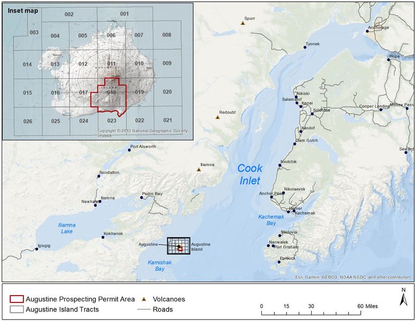
Figure 1. South Augustine Island Noncompetitive Geothermal Prospecting Permit Area ........................ 3-1
Figure 2. Landcover on Augustine Island. ................................................................................................. 4-2
Figure 3. Designated federal Endangered Species Act critical habitats near Augustine Island................. 4-4
Figure 4. Fish and wildlife use of habitats on and around Augustine Island. ............................................ 4-5
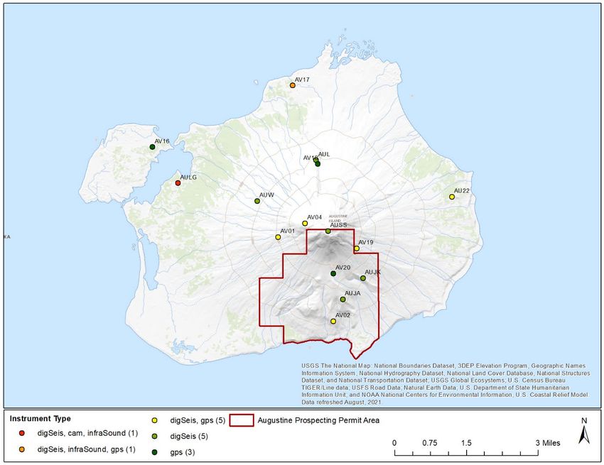
Figure 5. Alaska Volcano Observatory instrument stations on Augustine Island. .................................... 5-2
Figure 6. Commercial salmon harvest from the Kamishak Bay District (249).......................................... 5-3
Figure 7. Cook Inlet (Area H) groundfish harvest and exvessel value. ..................................................... 5-4
Figure 8. Commercial Pacific halibut harvest from Cook Inlet (statistical area 261). ............................... 5-5
Figure 9. Recreational salmon harvest from Cook Inlet saltwater. ............................................................ 5-6
Figure 10. Recreational Pacific halibut harvest from the central Gulf of Alaska (Area 3A). .................... 5-7
Figure 11. Energy infrastructure near Augustine Island. ........................................................................... 5-8
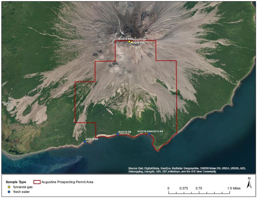
Figure 12. Fumarole gas and freshwater water samples in and near the Prospecting Permit
Area. ...................................................................................................................................... 8-3
List of Tables
Page
Table 1. Landcover in the Prospecting Permit Area and Augustine Island. .............................................. 4-1
Table 2. Shore types on Augustine Island.................................................................................................. 4-2
Table 3. Shoreline biobands on Augustine Island...................................................................................... 4-3
Table 4. Breeding birds potentially occurring on Augustine Island. ......................................................... 4-8
Table 5. State, federal, and local applicable laws, permits, approvals and consultations. ......................... 7-1
Table 6. Fumarole gas composition (by percent) for two fumaroles near the summit of
Augustine Volcano in the Prospecting Permit Area on July 27, 2010. ................................. 8-2
Table 7. Power plant emissions near Augustine Island and example geothermal plant
emissions. .............................................................................................................................. 8-4
Table 8. Water quality for two streams in the Prospecting Permit Area and a spring on
Augustine Island. .................................................................................................................. 8-6
South Augustine Island Noncompetitive Geothermal Prospecting Permit
iiiChapter One: Director’s Preliminary Written Finding and Decision
Chapter One: Director’s Preliminary
Written Finding and Decision
The Alaska Department of Natural Resources (DNR), Division of Oil and Gas (DO&G) administers the
geothermal exploration and development program for the State of Alaska. State lands with geothermal
potential may be disposed of through prospecting permits or leases to explore and develop geothermal
resources. Disposal of land for geothermal exploration and development may only occur after lands are
designated as a proposed geothermal disposal area and a best interest finding is issued authorizing the
disposal. Only state-owned, unencumbered lands will be available for permit or lease.
A. Procedural Background
Disposal of Augustine Island and surrounding state waters for geothermal exploration was approved on
January 14, 2013, with issuance of a written finding that determined that leasing tracts on and around
Augustine Island for geothermal exploration was in the state’s best interest. A lease sale held on May 8,
2013, offered 65,992 acres in 26 tracts with one bid received. No exploration was attempted, and this
lease (ADL 392470) was relinquished on October 8, 2014.
• The process for this South Augustine Island Noncompetitive Geothermal Prospecting Permit
(Prospecting Permit) was initiated with a proposal received on April 14, 2021, from GeoAlaska,
LLC (GeoAlaska).
• DO&G issued a call for public comments and competing proposals on June 29, 2021, for
65,992 acres in 26 tracts on and around Augustine Island.
• On July 30, 2021, the public comment period and call for competing proposals ended, and no
competing proposals or comments were received. Consequently, the current GeoAlaska proposal
is being offered as a noncompetitive prospecting permit for a period of 2 years at a rental rate of
$3/acre. This disposal is assigned to ADL 394080.
B. Statement of Applicable Law
The state has sufficient authority through general constitutional, statutory, and regulatory authority, the
terms of the disposal, and plans of exploration, operation, and development to ensure that
permittees/lessees conduct their activities safely and in a manner that protects the integrity of the
environment and maintains opportunities for other natural resource uses.
• Geothermal resource exploration and development is authorized under AS 38.05.181 with
regulatory guidance outlined at 11 AAC 84.700-950.
• State laws AS 38.05.035(e), AS 38.05.181, and 11 AAC 84.700(b) require that before approving
a geothermal prospecting permit, the director must determine whether the disposal is in the best
interest of the state.
• This written finding considers the potential that this Prospecting Permit may be converted to
leases if the conditions outlined in 11 AAC 84.740 are met. Mitigation measures included in
Chapter Nine would be carried forward on any subsequent permit or lease.
South Augustine Island Noncompetitive Geothermal Prospecting Permit
1-1Chapter One: Director’s Preliminary Written Finding and Decision
C. Analysis Summary
1. Area Description
The Prospecting Permit Area (Permit Area) covers approximately 3,048 acres in parts of 3 tracts on the
south side of Augustine Island. Augustine Island is within the Kenai Peninsula Borough (KPB) on the
west side of Lower Cook Inlet in Kamishak Bay. Geologic hazards from Augustine Volcano, an active
stratovolcano on Augustine Island include lahars, pyroclastic flows, debris avalanches, volcanic blasts,
and other volcano-related hazards. Geothermal resources in the form of hot water, hot dry steam, or hot
dry rock in the Permit Area are indicated by Augustine Volcano, although no hot springs are known from
Augustine Island.
Habitat, fish, and wildlife in the Permit Area are influenced by an island location and periodic eruptions
of Augustine Volcano (17.5-year average interval). Nearshore habitats support fish, waterfowl, seabirds,
and marine mammals. Intertidal wetlands are used by waterfowl primarily in summer, and rocky cliffs
especially near Burr Point on the north side of the island may contain nesting seabirds. Nearshore waters
support razor clam beds, Pacific herring spawning, southwest distinct population segment (DPS) northern
sea otter designated critical habitat, and harbor seal pupping and molting haulouts.
The primary use of Augustine Island is scientific research and monitoring of Augustine Volcano.
Nearshore waters provide habitat for salmon, halibut, and groundfish that support commercial and
recreational fisheries managed by Alaska Department of Fish and Game (ADF&G), North Pacific
Fisheries Management Council, National Marine Fisheries Service (NMFS), and International Pacific
Halibut Commission. Augustine Island and surrounding state waters are within the Anchorage – Mat-Su –
Kenai Peninsula nonsubsistence use area. Federal waters east of Augustine Island are used by Seldovia
residents for subsistence harvest of halibut, cod, black rockfish, and salmon.
2. Reasonably Foreseeable, Cumulative Effects
At the disposal phase, it is unknown whether geothermal resource exploration, development, power
production, or power transmission will be proposed, and if proposed, what the specific location, type,
size, extent, and duration would be. This finding discusses the potential cumulative effects, in general
terms, that may occur with geothermal exploration, development, power production, and power
transmission activities within the Permit Area considering mitigation measures that have been developed
for the Prospecting Permit and any subsequent leases. The director has limited the scope of the review for
this finding to the applicable statutes and regulations, facts, and issues pertaining to the Permit Area, and
the reasonably foreseeable significant cumulative effects of geothermal exploration and power
production.
Initial survey and exploration could include geological and geophysical surveys and exploratory drilling
to determine the size and temperature of the resource. If a commercially viable geothermal resource is
identified, development could include construction of well pads, wells, pipelines, power plant, roads,
personnel housing, transportation and maintenance facilities, and a subsea power cable.
South Augustine Island Noncompetitive Geothermal Prospecting Permit
1-2Chapter One: Director’s Preliminary Written Finding and Decision
a. Air Quality
Geothermal fluids contain dissolved carbon dioxide, hydrogen sulfide, ammonia, and methane gases
which are released during depressurization and cooling with hydrogen sulfide oxidizing to sulfur dioxide
and ammonia oxidizing to nitrogen oxides. Metal salts of mercury, boron, and arsenic may be released as
fine-grained particulates. Air emissions from geothermal power plants are orders of magnitude less than
conventional fossil-fuel power plants and US Environmental Protection Agency (EPA) and Alaska
Department of Environmental Conservation (ADEC) require industries to limit emissions that may affect
air quality. Industry compliance with regulations and measures would ensure that any incremental
increases in air pollution from geothermal power production would not result in significant cumulative
effects on air quality.
b. Water Quality
Well drilling, power plant construction and operation, and associated discharges, runoff, and water use
could affect water availability and quality. Discharge of geothermal wastewater may alter local water
quality and temperature. Facilities are required to control and manage stormwater and snow melt runoff to
avoid and minimize water pollution and discharges are regulated through ADEC's Alaska Pollutant
Discharge Elimination System program. Facilities are required to comply with solid waste, fuel, and
hazardous substance handling and storage regulations to avoid and minimize water pollution. Mitigation
measures address fuel and hazardous substance storage, transfer, and handling to further ensure protection
of surface and subsurface water resources. Industry compliance with regulations and mitigation measures
are expected to avoid, minimize, and mitigate potential cumulative effects on water resources.
c. Habitat, Fish, and Wildlife
Potential cumulative habitat, fish, and wildlife impacts from development of geothermal energy include
land use, water use, noise, solid and liquid waste generation, pollution, and waste heat generation.
Constructing a subsea power cable from Augustine Island would require trenching and burial that would
cross Essential Fish Habitat (EFH) for salmon, groundfish, and Pacific scallops, and Endangered Species
Act (ESA) designated critical habitat for southwest DPS northern sea otters. Dredging and cable
installation could lead to long-term or permanent damage depending on the extent and type of habitat
disturbed and mitigation measures used.
Disturbances that flush birds from nest sites may increase predation by bald eagles. Displacement of
waterbird adults or broods from preferred habitats during pre-nesting, nesting, and brood rearing can
cause disruption of courtship, chick loss, egg breakage, and predation. Sea otters and harbor seals may be
disturbed by aircraft and vessel traffic, as well as noise and activity from construction and operation of a
power plant. Potential cumulative effects from prolonged or repeated disturbance from traffic and noise
could include displacement from preferred feeding or haulout areas, increased stress and energy
expenditure, masking of communications, and impaired thermoregulation of neonates. Southwest DPS
northern sea otters are protected under both the ESA and the Marine Mammal Protection Act (MMPA)
and harbor seals are protected under MMPA. Typical MMPA required mitigation includes minimum
flight altitudes and separation distance; exclusion zones for in-water pile construction; and limiting vessel
approaches and speeds. Facility siting and aircraft routing to avoid sensitive habitats and haulouts during
sensitive periods would minimize potential disturbance of sea otters and harbor seals. Geothermal power
South Augustine Island Noncompetitive Geothermal Prospecting Permit
1-3Chapter One: Director’s Preliminary Written Finding and Decision plants must comply with local, state, and federal laws and regulations that protect sensitive habitats, and sensitive fish and wildlife. d. Uses Induced vibrations from equipment, vibrators, or small explosive charges for seismoelectric surveys, well drilling, and facility construction could interfere with equipment monitored by the Alaska Volcano Observatory (AVO). Removing and reinjecting geothermal fluids leads to subsurface pressure and temperature changes causing volume and stress changes that can induce earthquakes. Most geothermal- related induced seismicity occurs as low-magnitude microearthquakes (M
Chapter One: Director’s Preliminary Written Finding and Decision

and subsistence fisheries harvest activities; management of fuels, hazardous substances, and wastes;
potential spills of geothermal fluids and hazardous substances; and siting of facilities and operations.
DNR may impose additional requirements necessary to protect the state’s interest during approval of later
phase activities.

D. Preliminary Decision and Request for Public Comments
The director considered all applicable statutes and regulations, weighed the facts, and balanced the
potential positive and negative effects of geothermal exploration, development, and power production
activities in the Permit Area during the development of this preliminary finding. The relevant facts and
issues made known within the scope of this review include: the value of research and monitoring of
Augustine Volcano; the value of habitat, fish, and wildlife; the value of Lower Cook Inlet commercial and
recreational fisheries; potential cumulative effects from a geothermal power plant on Augustine Island;
and potential benefits of a geothermal energy source for southcentral Alaska. The director preliminarily
finds the potential benefits of issuing this Prospecting Permit outweigh the potential negative effects, such
that issuance of the South Augustine Island Noncompetitive Geothermal Prospecting Permit serves the
best interests of the State of Alaska.

This preliminary finding is subject to revision based on comments received by DO&G during the period
set out for receipt of public comment, as provided in AS 38.05.035(e)(5)(A). Members of the public are
encouraged to comment on any part of this preliminary finding. In commenting, please be as specific as
possible.

Comments must be in writing and received by May 30, 2022, in order to be considered and must be sent
to Best Interest Findings:

        By mail:         Alaska Department of Natural Resources
                         Division of Oil and Gas
                         550 W 7th Ave, Suite 1100
                         Anchorage AK 99501-3560

        By fax:          907-269-8938

        By email:        dog.bif@alaska.gov

DO&G complies with Title II of the Americans with Disabilities Act of 1990. This publication will be
made available in alternate communication formats upon request. Please contact the Best Interest
Findings Group at (907) 269-8800 or dog.bif@alaska.gov. Requests for assistance must be received at
least 96 hours prior to the comment deadline to ensure necessary accommodations can be provided.

Following review of comments on this preliminary written finding and any additional relevant
information, the director will make a final determination whether disposal of geothermal resources in the
Permit Area is in the best interest of the state and will issue a final finding and decision. To be eligible to
file an appeal of the final finding to the DNR commissioner under AS 38.05.035(i), a person must provide
written comments during the comment period of this preliminary finding set out in the previous
paragraph. Additional information regarding the public comment process and requests for reconsideration

                     South Augustine Island Noncompetitive Geothermal Prospecting Permit

                                                      1-5
Chapter One: Director’s Preliminary Written Finding and Decision
and appeals can be found in Chapter Two. A copy of the final decision can be sent to any person
commenting on the preliminary decision and will include an explanation of the appeal process.
/s1/ _ _ _
Derek W. Nottingham
Director, Division of Oil and Gas
South Augustine Island Noncompetitive Geothermal Prospecting Permit
1-6Chapter Two: Authority and Scope of Review
Chapter Two: Authority and Scope of
Review
The Alaska Constitution provides that the state’s policy is “to encourage . . . the development of its
resources by making them available for maximum use consistent with the public interest” and that the
“legislature shall provide for the utilization, development, and conservation of all natural resources
belonging to the State . . . for the maximum benefit of its people” (Alaska Constitution, Article VIII, §1
and 2). To comply with this provision, the legislature enacted Title 38 of the Alaska Statutes (AS 38) and
directed the Alaska Department of Natural Resources (DNR) to implement the statutes.
A. Authority
The state may develop geothermal resources under the statutory guidance of AS 38.05.181. The
procedures for disposal of geothermal resources are set out in regulations 11 AAC 84.700-790. Other
agencies also have jurisdiction for activities resulting from resources exploration, development, and
production. Disposal of the Augustine Island area for geothermal exploration was first approved on
January 14, 2013. A geothermal lease sale was held on May 8, 2013, and 65,992 acres in 26 tracts were
offered. One bid was received on Tract 13.
Alaska statutes govern the disposal of state-owned subsurface interests. Under AS 38.05.035(e), the DNR
director may not dispose of state land, resources, property, or interests unless the director, with the
consent of the commissioner, first determines in a written finding that such action will serve the best
interests of the state.
The process for the South Augustine Island Noncompetitive Geothermal Prospecting Permit (Prospecting
Permit) was initiated in response to a proposal received on April 14, 2021, from GeoAlaska, LLC
(GeoAlaska). GeoAlaska applied for a prospecting permit covering about 3,048 acres on the southern end
of Augustine Island. Next, DNR’s Division of Oil and Gas (DO&G) issued a call for public comments
and competing proposals on June 29, 2021. The area included in the call for competing proposals
consisted of 26 tracts comprising approximately 65,992 acres. This expanded acreage was used in the call
for competing proposals to disguise GeoAlaska’s initial request for 3,048 acres in 3 tracts located on the
south side of Augustine Island and to give any competitors an opportunity to apply for coinciding or
adjacent lands for geothermal exploration. On July 30, 2021, the public comment period and call for
competing proposals ended, and no competing proposals or comments were received. Therefore, this
Prospecting Permit is being offered as a non-competitive Prospecting Permit for a period of 2 years at a
rental rate of $3/acre. The Prospecting Permit can be renewed for an additional year if the permittee has
been unable to show a discovery of geothermal resources in commercial quantities despite showing
reasonable diligence as defined in 11 AAC 84.730(b).
B. Scope of Review
As required by AS 38.05.035(e)(1)(A)–(C), the director, in the written finding:
1. shall establish the scope of the administrative review on which the director’s determination is
based, the scope of the written finding supporting that determination, and the scope of the
South Augustine Island Noncompetitive Geothermal Prospecting Permit
2-1Chapter Two: Authority and Scope of Review
administrative review and finding may only address reasonably foreseeable, significant effects of
the uses proposed to be authorized by the disposal;
2. may limit the scope of an administrative review and finding for a proposed disposal to a review of
(1) applicable statutes and regulations, (2) facts pertaining to the land, resources or property, or
interest in them that are material to the determination and known to the director or knowledge of
which is made available to the director during the administrative review, and (3) issues that,
based on the applicable statutes, regulations, facts, and the nature of the uses sought to be
authorized by the disposal, the director finds are material to the determination of whether the
proposed disposal will serve the best interests of the state; and
3. may, if the project for which the proposed disposal is sought is a multi-phased development, limit
the scope of an administrative review and finding for the proposed disposal to the applicable
statutes, and regulations, facts and issues that pertain solely to the disposal phase of a project
when the conditions of AS 38.05.035(e)(1)(C)(i)–(iv) are met.
1. Reasonably Foreseeable Effects
The scope of the administrative review and finding may address only reasonably foreseeable, significant
effects of the uses proposed to be authorized by the disposal (AS 38.05.035(e)(1)(A)). The director does
not speculate about possible future effects (AS 38.05.035(h)).
For an effect to be “reasonably foreseeable”, there must be (1) some cause/result connection between the
proposed disposal and the effect to be evaluated; (2) a reasonable probability that the effect will occur as a
result of the disposal; and (3) the effect will occur within a predictable time after the disposal. Therefore,
this finding does not speculate about future effects, but instead reviews only reasonably foreseeable
effects of the proposed disposal. A reasonably foreseeable effect must also be “significant.” Significant
means a known and noticeable impact on or within a reasonable proximity to the area involved in the
disposal.
2. Matters Considered and Discussed
Further, the director may limit the scope of an administrative review and finding for a proposed disposal
to:
• applicable statutes and regulations;
• the facts pertaining to the land, resources, or property, or interest in them, that the director finds
are material to the determination and that are known to the director or knowledge of which is
made available to the director during the administrative review; and
• issues that, based on the statutes and regulations, on the facts as described, and on the nature of
the uses sought to be authorized by the disposal, the director finds are material to the
determination of whether the proposed disposal will best serve the interests of the state
(AS 38.05.035(e)(1)(B)).
The scope of review in this finding addresses the reasonably foreseeable, significant effects of the uses to
be authorized by the proposed disposal and is limited to the applicable statutes and regulations, the
material facts and issues known to the director that pertain to the Prospecting Permit disposal phase, and
South Augustine Island Noncompetitive Geothermal Prospecting Permit
2-2Chapter Two: Authority and Scope of Review
issues that the director finds are material to the determination of whether the proposed disposal will best
serve the interests of the state.
In preparing this written finding, the director considers and discusses facts related to topics set out under
AS 38.05.035(g)(1)(B)(i)–(x) applied to geothermal resource exploration and development, and
geothermal power production and transmission that are known at the time the finding is being prepared.
The director must also consider public comments during the public comment period that are within the
scope of review. The scope of this administrative review considers reasonably foreseeable effects on the
Permit Area, approximately 3,048 acres in 3 tracts located on the south side of Augustine Island, and the
surrounding environment. Figure 1 in Chapter Three depicts the location of the Permit Area.
3. Review by Phase
The director may limit the scope of an administrative review and finding for a proposed disposal to
evaluate the potential effects of the proposed disposal when the director has sufficient information and
data available upon which to make a reasoned decision.
Under AS 38.05.035(e)(1)(C), if the project for which the proposed disposal is sought is a multi-phased
development, the director may limit the scope of an administrative review and finding for the proposed
disposal to the applicable statutes and regulations, facts, and issues identified above pertaining solely to
the disposal phase of the project under the following conditions:
(i) the only uses to be authorized by the disposal are part of that phase;
(ii) the disposal grants the permittee the exclusive right to prospect for geothermal resources on state
land included under the permit, and, before the next phase of the project may proceed, public
notice and the opportunity to comment are provided under regulations adopted by the
department;
(iii) the department’s approval is required before the next phase may proceed; and
(iv) the department describes its reasons for a decision to phase.
Here, the director has met condition (i) because the only uses authorized are part of the disposal phase.
The disposal phase is the Prospecting Permit phase of this project. As defined in Kachemak Bay
Conservation Society v. State, Department of Natural Resources, “disposal” is a catch all term for all
alienations of state land and interests in state land. 1 In Northern Alaska Environmental Center v. State,
Department of Natural Resources, the court further held that a disposal was a conveyance of a property
right. 2 For a geothermal development project, the lease or prospecting permit is the only conveyance of
property rights DNR approves. The prospecting permit or lease gives the permittee or lessee, subject to
the provisions of the permit or lease and applicable law the exclusive right to drill for, extract, remove,
and process geothermal resources, as well as the nonexclusive right to conduct within the permitted or
leased area geological and geophysical exploration for geothermal resources, the nonexclusive right to
install pipelines and build structures on the Prospecting Permit Area or lease to find, produce, save, store,
take care of, and market all geothermal resources, and to house and board employees in its operations on
1
6 P.3d 270, 278 n.21 (Alaska 2000).
2
2 P.3d 629, 635-36 (Alaska 2000).
South Augustine Island Noncompetitive Geothermal Prospecting Permit
2-3Chapter Two: Authority and Scope of Review
the Prospecting Permit Area or lease area. While the permittee or lessee has these property rights upon
entering into the prospecting permit or lease, the prospecting permit or lease itself does not authorize any
geothermal exploration activities on the prospecting permitted or leased tracts without further permits
from DNR and other agencies. There are no additional property rights to be conveyed at later phases.
Condition (ii) is met, first, because this Prospecting Permit is for the disposal of available land or an
interest in land, for geothermal resources. Second, condition (ii) is met because public notice and
opportunity to comment are provided for each phase of a project. Public notice and the opportunity to
comment on the disposal phase of a prospecting permit is provided through the preliminary best interest
finding under AS 38.05.035(e), AS 38.05.945, and 11 AAC 84.720(c). Subsequent post-disposal phases
may not proceed unless public notice and the opportunity to comment are provided under regulations
adopted by DNR. DNR provides public notice and opportunity to comment for plans of operation that
initiate a new phase under 11 AAC 84 as authorized by AS 38.05.
Condition (iii) is met because DNR’s approval is required before the next phase may proceed.
Condition (iv) is met by the findings in Chapter One discussing the speculative nature of current
information on what future development projects and methods may be proposed that would require post-
disposal authorizations; and what permit conditions and mitigation requirements will be appropriate for
authorizations at later phases.
This preliminary best interest finding satisfies the requirements for phased review under AS
38.05.035(e)(1)(C).
C. Appeal
A person affected by this decision may appeal it in accordance with 11 AAC 02. Any appeal must be
received within 20 calendar days after the date of “issuance” of this decision, as defined in 11 AAC
02.040(c) and (d) and may be mailed or delivered to the Commissioner, Department of Natural
Resources, 550 W. 7th Avenue, Suite 1400, Anchorage, Alaska 99501; faxed to 1-(907) 269-8918, or sent
by electronic mail to dnr.appeals@alaska.gov. Under 11 AAC 02.030, appeals and requests for
reconsideration filed under 11 AAC 02 must be accompanied by the fee established in 11 AAC
05.160(d)(1)(F), which has been set at $200 under the provisions of 11 AAC 05.160 (a) and (b).
An eligible person must first appeal this decision in accordance with 11 AAC 02 before appealing this
decision to the Superior Court. A copy of 11 AAC 02 may be obtained from any regional information
office of the Department of Natural Resources.
South Augustine Island Noncompetitive Geothermal Prospecting Permit
2-4Chapter Three: Description of the Disposal Area
Chapter Three: Description of the Disposal
Area
A. Property Description
Augustine Island is in Kamishak Bay on the west side of Lower Cook Inlet, approximately 68 miles
southwest of Homer and approximately 170 miles south-southwest of Anchorage. West of Augustine
Island are the Chigmit and Alaska-Aleutian mountain ranges. Augustine Island has been augmented by
numerous eruptions of Augustine Volcano from which debris avalanches and lahars have deposited
sediment on the flanks of the volcanic cone and in the surrounding waters.
The South Augustine Island Noncompetitive Geothermal Prospecting Permit Area (Permit Area) consists
of the southern portion of Augustine Island. The Permit Area contains about 3,048 acres of onshore
portions of 3 tracts, ranging from 320 to 2,240 acres (Figure 1). The state owns the land within the Permit
Area, and Augustine Island is entirely located within the Kenai Peninsula Borough (KPB).
Figure 1. South Augustine Island Noncompetitive Geothermal Prospecting Permit Area
South Augustine Island Noncompetitive Geothermal Prospecting Permit
3-1Chapter Three: Description of the Disposal Area
B. Cultural and Historical Background and Resources
At the time of first European contact, Dena’ina Indians occupied the Cook Inlet area. These nomadic
bands came to the region about AD 500 to 1000 (CIRI 2021). Evidence from the Yukon Island site in
Kachemak Bay shows that Lower Cook Inlet was occupied by Eskimos from about 1500 BC to AD 1000
and then later by Athabaskan Indians (Selkregg 1975). Although historical subsistence hunting and
gathering has occurred near Augustine Island, there are no records of settlements on the island aside from
a remote, abandoned cabin likely used by miners during a brief stint of pumice mining on the island in the
late 1940s. No historic or prehistoric sites are reported on Augustine Island (OHA 2021; Weinberger
2021).
C. Geologic Hazards
Augustine Volcano is an active volcano in the Cook Inlet region and presents several potential geologic
hazards to the island and surrounding waters (Waitt and Beget 2009). Augustine Volcano is the most
historically active volcano in the Cook Inlet region. Escalating seismic unrest, ground deformation, and
gas emissions culminated in an eruption from January 11 to mid-March of 2006, the fifth major eruption
in 75 years (Power et al. 2010). Hazardous phenomena recorded at Augustine Island include volcanic ash
clouds, ash fallout and volcanic bombs, pyroclastic flows, debris avalanches, tsunamis, earthquakes,
directed blasts, lahars and floods, volcanic gases, and lava flow (Waythomas and Waitt 1998). Augustine
Volcano has experienced major eruptions since 1883, such as eruptions in 1935, 1963 to 1964, 1976,
1986, and 2006 (Nye 2007). In early 2006, eruptive events resulted in explosive ash, pyroclastic flow
eruptions, and lava dome eruptions (Beget and Kowalik 2006). By mid-2006, avalanche events and
pyroclastic flows decreased with the exception of a minor spike in such events during April, in which
several rock falls and avalanches contributed to the formation of an ash blanket on the southwest flank of
Augustine Volcano (Waythomas and Waitt 1998).
1. Volcanic Ash Clouds, Ash Fallout and Volcanic Bombs
Historically, Augustine Volcano has explosively erupted, sometimes ejecting very large fragments of
magma thousands of feet into the atmosphere. Ashfall occurs when clouds of ash accumulate and fall to
the earth as they drift away from the volcano. Depending on the extent or thickness of the ashfall,
infrastructure may collapse under the added weight of ash. Public health is a concern during periods of
ashfall as inhaling volcanic ash can cause respiratory issues and may significantly decrease visibility
(Waythomas and Waitt 1998).
Larger-sized volcanic debris, called blocks or bombs, typically strike near the vent of the volcano.
Microscopic ash or tephra ejected from the volcano form ash clouds which may drift in the wind for
several weeks or days and pose potential threats to air travel. The Alaska Volcano Observatory (AVO)
reported that ash clouds from the 1976 and 1986 eruptions reached altitudes higher than 40,000 feet
(12,000 meters) in height. In 1976, five jet liners experienced severe abrasion on exterior parts of the
aircraft, but no crashes resulted from the ash cloud encounters. In March 1986, a DC-10 aircraft
encountered an Augustine Volcano ash cloud during descent into Anchorage International Airport, but
landed safely, and air traffic was routed around the ash cloud for several days (Waythomas and Waitt
1998).
South Augustine Island Noncompetitive Geothermal Prospecting Permit
3-2Chapter Three: Description of the Disposal Area
Significant ashfall and volcanic debris would impact workers and infrastructure on Augustine Island
leading to power plant shut down and the need to protect and evacuate workers. Mitigation measures in
Chapter Nine include development of a plan to address potential geohazard impacts on operations to
mitigate risk to facilities and personnel and coordination with the Alaska Volcano Observatory to ensure
that the permittee or operator is always aware of Augustine Volcano’s current activity status when
personnel are on Augustine Island.
2. Pyroclastic Flows, Landslides, and Debris Avalanches
A pyroclastic flow is a hot fast-moving mixture of volcanic rock, debris, and gas that flows downslope
during eruptive events. Pyroclastic flows may result from explosive eruptions or collapse of the lava
dome. As the lava dome cools, it may collapse and fall back toward the volcano moving debris downslope
several miles beyond the vent (Waythomas and Waitt 1998; USGS 2011). The cone of Augustine
Volcano has been built up vertically over the last 2,000 years causing about a dozen major avalanches and
creating areas of hummocky topography on Augustine Island and irregular bathymetry in nearshore
waters (Waythomas and Waitt 1998; Nye 2007).
Landslides are common on volcanic cones and the surrounding areas because they are typically tall, steep,
and weakened by the rise and eruption of molten rock. Magma releases volcanic gases that can partially
dissolve in groundwater. The released gasses can result in a hot acidic hydrothermal system that weakens
rock formations. The layers of lava and loose fragmented rock debris can lead to fault zones that move
frequently. Landslides can cross valley divides and run up slopes several hundred yards high. Geothermal
resources are often located under steep terrain, and development may require substantial excavation to
prepare facility sites. Extensive excavation can trigger erosion and landslides could occur. Slopes
underlain by weak bedrock can be a serious engineering problem (USGS 2021).
A debris avalanche is the rapid downslope movement of rock, volcanic debris, snow, ice, or other
pyroclastic materials. Debris avalanches are not always associated with eruptive events, heavy rainfall,
the intrusion of magma, or earthquakes can also cause catastrophic avalanches (USGS 2015a). Pyroclastic
flows and debris avalanches can move at speeds of 3 to 6 miles per second, creating a serious hazard to
life and property on the island (Waythomas and Waitt 1998). An eruption in 1976 caused a pyroclastic
flow which damaged AVO infrastructure and equipment on the north shore of the island (Nye 2007).
Pyroclastic flows and debris avalanches moving rapidly down the volcano flank can extend beyond
tidelands, potentially generating tsunamis (Waythomas and Waitt 1998; Nye 2007). The topography of
Augustine Island would cause a pyroclastic flow to spread out laterally from the vent, although it is
unlikely that a flow would reach more than 3 miles off the island’s shore (Waythomas and Waitt 1998).
Some slopes in the Permit Area are composed of volcanic ash and could be unstable. Design and
construction of all drill pads built in the Permit Area must be approved through the plan of operations
process by Division of Oil and Gas (DO&G), and sound engineering practices will be required to prevent
poor siting of facilities. Mitigation measures are included in Chapter Nine.
3. Tsunamis
A tsunami can be generated by land-based and submarine landslides, volcanic eruptions, calving glaciers,
underwater explosions, or meteorite impacts. Volcanic debris flowing rapidly into Cook Inlet during a
large eruption of Augustine Volcano can result in generation of a tsunami wave. Several previous
South Augustine Island Noncompetitive Geothermal Prospecting Permit
3-3Chapter Three: Description of the Disposal Area
eruptions have initiated pyroclastic flows which reached surrounding waters. The 1883 eruption appears
to have caused a debris avalanche that initiated a tsunami observed at English Bay, at the location of
modern day Nanwalek and Port Graham (Waythomas and Waitt 1998). This tsunami flooded coastal
homes and washed away kayaks although no fatalities were reported (Beget and Kowalik 2006). There is
potential for a large debris avalanche from Augustine Volcano to flow into lower Cook Inlet and create a
radiating tsunami (Waitt 2010). Tsunami magnitude is based on several factors: the volume and velocity
of debris, water depth in the runout zone, and the position of tides during the eruption. Low-lying areas
along the coastline of lower Cook Inlet would be most susceptible to a tsunami, especially if an eruptive
event occurred during high tide (Waythomas and Waitt 1998).
A tsunami generated by any source that reaches Augustine Island could flood or damage infrastructure in
low-lying areas, especially any coastal docks or marine floatplane landing areas that could limit
subsequent access to the island. Siting for power plants, drill pads, and associated facilities should
consider elevation and tsunami hazards. Alaska Department of Natural Resources, Division of Geological
and Geophysical Surveys with the University of Alaska’s Geophysical Institute have created tsunami
inundation maps for vulnerable coastal communities based on earthquake scenarios and tsunami wave
propagation modeling to estimate worst-case flooding (Salisbury and Janssen 2019). Similar modeling
could be used to estimate tsunami risk by elevation on Augustine Island to assist with facility siting.
Design and construction of all drill pads built in the Permit Area must be approved through the plan of
operations process by Division of Oil and Gas (DO&G), and sound engineering practices will be required
to prevent poor siting of facilities. Mitigation measures are included in Chapter Nine.
4. Earthquakes and Induced Seismicity
Augustine Island is vulnerable to naturally occurring subduction zone earthquakes, that are caused by one
geologic crustal plate moving beneath another. In Southcentral Alaska, the oceanic Pacific Plate is slowly
subducting beneath the continental North American Plate. Volcanoes, such as Augustine and those
located on the Aleutian Islands, are associated with this type of tectonic plate convergence. Earthquakes
can trigger landslides, avalanches, tsunamis, uplift, subsidence, infrastructure failure, and soil liquefaction
(DHSEM 2018).
Geothermal fields are typically located in seismically active areas or along active faults. Because
geothermal resource extraction redistributes fluid pressure in the reservoir, earthquakes could be
triggered. Geothermal fields in tectonically active regions often show increased seismicity, but not always
of large magnitude (Buijze et al. 2019). Increased seismicity from geothermal power production could be
hazardous to power plant operations and adjoining land uses. The state may install seismographs or other
instruments in producing geothermal fields to detect induced seismic activity. If geothermal production
induces seismicity, and if induced seismicity could be hazardous, the permittee will be required to adjust
production and injection rates or to suspend operations under mitigation measures in Chapter Nine.
5. Directed Blasts and Lava Flow
A directed blast is a large explosion which can occur if a volcano’s internal vent system becomes
compromised or uncapped. Directed blasts of Augustine Volcano are rare; there is evidence of only one
directed blast occurring in the last 400 years. A directed blast at Augustine Island would happen quickly,
leaving little or no time for evacuation, and would destroy anything in the immediate vicinity by impact,
burial, and intense heat (Waythomas and Waitt 1998).
South Augustine Island Noncompetitive Geothermal Prospecting Permit
3-4You can also read