Spatial Data Model Design for the Need to Identify Green Property Rights
←
→
Page content transcription
If your browser does not render page correctly, please read the page content below
Spatial Data Model Design for the Need to Identify Green Property Rights

                   Tugba MEMISOGLU BAYKAL and H. Ebru COLAK, Turkey

   Key words: Property; Green Property Right; Ecological Site; Cadastre 2014; Cadastre 2014
   and Beyond; Turkey

   SUMMARY

   Turkish cadastral system is based on well-founded basis cadastral systems. Especially with
   the development of digital cadastre, data of cadastral parcels have been digitized, thus, access
   to a lot of information about the parcels has become easier. However, the studies show that
   the information about the restrictions on the cadastral parcels is not available in digital
   environment, access can be obtained by examining the land registry records and these
   restrictions are not handled within a proper system. It also shows that although these
   restrictions are in the land registry records, their restrictive nature is not fully set to a standard
   and does not fully define the use of green property rights. In Turkey, when the restrictions on
   cadastral parcels are examined, it is seen that these are registered within the framework of
   easement rights / limited real rights. However, it is seen that records where parcel usage is
   defined, records of green property rights associated with cadastral parcels and records
   describing the restricted and protected ecological areas corresponding to the cadastral parcel
   unfortunately not found. Therefore, there arises a need to identify this area as a single whole.

   International Federation of Surveyors (FIG), in 2014, which is the year of realization of the
   Cadastre 2014 vision, has published another study that assesses the impact of this report and
   includes new insights for the post-2014 period. In the "Cadastre 2014 and Beyond" report
   called the future of the cadastre; a report item has been published about ecological boundaries
   or green property rights. In short, with this item, emphasis has been given to the need defining
   green property rights and designing a model based on ecological boundaries in defining these
   areas. In light of this information in this declaration, since the restrictions of cadastral parcels
   are not defined in detail in these records and cannot be digitized in Turkey, the framework of
   a model will be examined in which important constraints on cadastral parcels will be
   determined. In particular, in this study, climate and ecological boundary determination using
   GIS, it will be considered within a certain standard and the framework of the need to develop
   the spatial data model design for defining green property will be examined.

Spatial Data Model Design for the Need to Identify Green Property Rights (10868)
Tugba Memisoglu Baykal and H. Ebru Colak (Turkey)
FIG e-Working Week 2021
Smart Surveyors for Land and Water Management - Challenges in a New Reality
Virtually in the Netherlands, 21–25 June 2021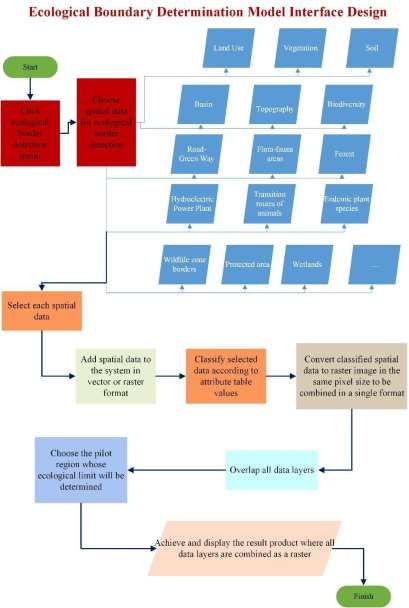
1. INTRODUCTION

    Land is one of the most important resources that people need since its existence. With this
    aspect, it stands out as the most important building block of the cadastre concept (Tudes
    and Biyik, 1994; Kaufmann and Steudler, 1998). All innovative pursuits based on the
    development of cadastre reveals its importance to handle the land which is the building
    block of the cadastre with different approaches to ensure the highest level of use. Land is
    called cadastre and the first thing that comes to mind when it comes to land is cadastral
    parcels that are subject to property (Kaufmann and Steudler, 1998). Therefore, it expresses
    that the innovative cadastre approach is directly related to cadastral parcels. Cadastre's
    change and progress with innovative approaches directly affects the changes in the cadastre
    parcels owned by people. In this context, the most important innovative development
    affecting cadastre parcel is to create more qualified parcels.

    Although the Cadastre 2014 vision, which aims to contribute to the future cadastral system
    visions by identifying the missing aspects of the cadastral system, is sufficient within the
    scope of cadastral foresight projections, it cannot fully meet the creation of parcel qualities.
    In this respect, the necessity of addressing the new vision in the context of managing the
    land for 2014 has emerged, this has led to the introduction of a new trend today, with the
    concepts of 'fit for purpose cadastre' and 'land rights and continuity of registration'
    (Kaufmann and Steudler, 1998).

    At the FIG congress held in 2010, Australian scientists published articles on the role and
    structure of the future cadastre as “Cadastre 2014 and Beyond” (Yomralıoglu et al. 2003;
    Lemmens, 2010; 2010a). Within the framework of this vision, studies on determining and
    defining ecological boundaries or green property rights are pointed out (Bennett, 2014).
    Therefore, with the proposed vision framework, the emphasis is strongly made revealing a
    new definition in cadastral structure, thus creating more understandable cadastral parcels
    and identification of ecological boundaries or green property rights with inventory that can
    be protected.

    From the statement of defining the green property right, within the scope of this study, it is
    suggested to make the inference of defining property uses and restrictions by defining
    basically qualified cadastral parcel. In short, it is the identification of the parcels that the
    right to property is discussed in detail, it is possible to reach the details of cadastre plots in
    protection oriented applications completely, quickly and easily and it is possible to access
    the restrictions on the location, if any, from the land registry information. Thus,
    conveniences will be provided to in applications for the realization of healthy land policies,
    in situations that will constitute a basis for planning, fit for purpose cadaster applications
    and at the point of accessing information on the cadastral parcel.

Spatial Data Model Design for the Need to Identify Green Property Rights (10868)
Tugba Memisoglu Baykal and H. Ebru Colak (Turkey)
FIG e-Working Week 2021
Smart Surveyors for Land and Water Management - Challenges in a New Reality
Virtually in the Netherlands, 21–25 June 2021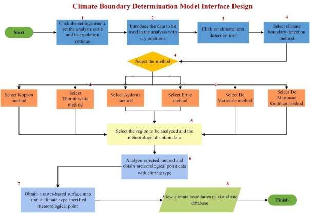
In this context, the researches give importance to the determination of the ecological
   boundaries and the climatic boundaries accordingly in order to define the green property right
   and to obtain qualified land information. So the owner of the property could benefit from a
   high level of property, for the production of areas that require climatic and ecological
   protection and the determination of property boundaries accordingly will be able to access
   information about cadastral parcels. Besides, in any planning situation, it will be very easy to
   be able to access information quickly and that all these are presented on the system as a
   whole. In addition, access to qualified land information on property is not only by looking at
   the land registry records, it will be provided easier and faster via coordinated systems and as a
   result, a new quality or identity will be given to the cadastral parcels.

        2. AIM OF STUDY

   The purpose of this study is to consider a spatial data model design to provide spatial
   descriptions of ecological boundaries that have special features and should be protected, to
   take into account the climate limits, which are an important part of ecology and by associating
   them with the cadastral parcels. Thus, a work will be carried out to meet the aims of
   developing usage restriction policy. Geographical Information Systems (GIS) technology
   provides important advantages in responding to these needs and producing models. Under
   normal conditions, analyzes that are planned to be carried out are carried out with more than
   one operation step through these software and the result is achieved. Since GIS software is
   multifunctional software, helps the user to provide the analysis they want to perform quickly
   and dynamically through personalized interfaces. Therefore, in this study, considering the
   advantageous aspect of GIS technology, the interface model design, which will define parcel
   qualifies depending on the climate-ecological boundaries, is discussed. Interface to be
   developed is in the form of a model interface designed in GIS technologies, which enables
   dynamic definition of parcel qualifies definition based on climate boundaries and ecological
   boundaries.

   In the first stage on this interface to be produced, determination of climate boundary will be
   realized. With the meteorological station points that record climate data in the pilot region,
   holistic climate boundary maps of the pilot region to be selected can be produced. In the
   second stage, by using land use, vegetation, protected areas, soil, flora-fauna, natural
   protected areas, biodiversity, wildlife borders etc., it will be able to identify areas that need to
   be protected ecologically and that will serve planning. At the last stage, the interface design
   will be handled one by one, where climate borders and ecological borders will be overlaid
   with the cadastral parcel, and qualified parcel definitions will be made.

            2.1. Cadastre 2014

   Cadastre; is defined as public inventories where the property data of a land, region or country
   whose borders are determined according to a certain measurement method are recorded and
   arranged within a system (Kaufmann and Steudler, 1998; Yomralıoğlu et al., 2003).
   Cadastre from the day it was discovered, undergoes change and development and shows

Spatial Data
Spatial      Model Design
        Data Model Design for
                          for the
                              the Need
                                  Need toto Identify
                                            Identify Green
                                                      Green Property
                                                            Property Rights
                                                                     Rights (10868)
                                                                            (10868)
Tugba Memisoglu
Tugba   MemisogluBaykal  andand
                    Baykal    H. Ebru ColakColak
                                  H. Ebru      (Turkey)
                                                     (Turkey)

FIG e-Working
FIG  eWorkingWeek Week2021
                         2021
Smart Surveyors
Smart Surveyors for
                  for Land
                      Land and
                           and Water
                               Water Management - Challenges in a New Reality
Virtually in theChallenges
Management,      Netherlands, 21–25
                           in A NewJune  2021
                                     Reality
The Netherlands, 20-25 June 2021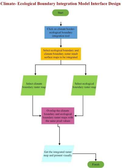
development in the cadastral system on which it is based. The cadastral system towards the
   end of the twentieth century has begun to be handled differently and is trying to be developed
   with the development of technology, the emergence of new visions and models (Kaufmann
   and Steudler, 1998; Van Oosterom et al., 2006; Enemark, 2010; Enemark, 2012a).
   Especially in recent years, studies such as multi-purpose cadastre, Land administration
   Domain Model, Land Management Model, Cadastre 2014 declaration and Cadastre 2014 and
   Beyond that plays a role in the change of cadastral structure. Cadastre 2014 is the vision of
   how the cadastre will evolve and what will be the new developments in the cadastre system
   by the 7th Commission at the 20th International Federation of Surveyors (FIG) Congress held
   in 1994 (Yomralıoğlu, et al. 2003; Lemmen, 2010). According to this vision, all restrictions
   and restrictions on the land should be laid out legally, and the distinction between land
   registry and cadastre should be eliminated and cadastral maps should be defined with dynamic
   based spatial data models (Kaufmann and Steudler, 1998; Kaufmann, 2004; Yomralıoglu,
   vd. 2003).

            2.2. Cadastre 2014 and Beyond

   Although the cadastral base currently considered within the scope of the Cadastre 2014 vision
   is sufficient within the scope of the forecasts, the necessity of addressing the new vision in the
   context of managing the land has emerged after 2014. This has led to the introduction of a
   new trend today, with the concepts of 'fit for purpose cadastre' and 'land rights and continuity
   of registration'. This new vision framework, called the "Cadastre 2014 and Beyond" vision, is
   the vision framework that emphasizes the need to consider the social and technological
   dynamics that will affect land management with a future-oriented planning in the next 20
   years (Yomralıoglu et al., 2003). At the FIG congress held in 2010, Australian scientists
   published articles regarding the role and structure of the cadastre in the future as "Cadastre
   2014 and Beyond (Beyond Cadastre 2014)” (Yomralıoglu et al. 2003; Lemmens, 2010;
   2010a). Highlighted in these articles; cadastral approach is to be addressed that is taking into
   account the measurement accuracy, having an object oriented structure, deals with 3D and 4D
   cadastre, able to work in a standard structure in both national and international context and
   determining ecological boundaries or green property rights. In this declaration, a spatial
   model design has been created and presented in which a qualified parcel can be defined to
   help define the green property right for Article 6, which is expected by the vision of Cadastre
   2014 and Beyond.

        3. SPATIAL DATA MODEL DESIGN

        3.1. IKEKONIP Interface Model Design

   Model interface design that is planned to be made is a model (IKEKONIP) design that is
   presented over the interface to be developed in GIS software. This model design helps define
   an automated green property by evaluating spatial data together and as a result, and ultimately
   it is a design that ensures the cadastre parcel to be qualified. This model (IKEKONIP)
   supplies to determined climate boundaries by climate classification methods; to determined

Spatial Data
Spatial      Model Design
        Data Model Design for
                          for the
                              the Need
                                  Need toto Identify
                                            Identify Green
                                                      Green Property
                                                            Property Rights
                                                                     Rights (10868)
                                                                            (10868)
Tugba Memisoglu
Tugba   MemisogluBaykal  andand
                    Baykal    H. Ebru ColakColak
                                  H. Ebru      (Turkey)
                                                     (Turkey)

FIG e-Working
FIG  eWorkingWeek Week2021
                         2021
Smart Surveyors
Smart Surveyors for
                  for Land
                      Land and
                           and Water
                               Water Management - Challenges in a New Reality
Virtually in theChallenges
Management,      Netherlands, 21–25
                           in A NewJune  2021
                                     Reality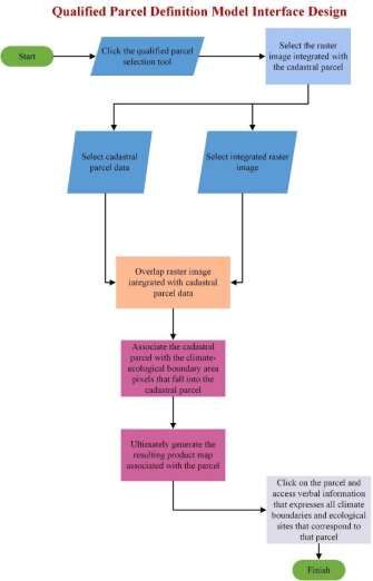
ecological boundaries by evaluating the climate and other important criteria together and as a
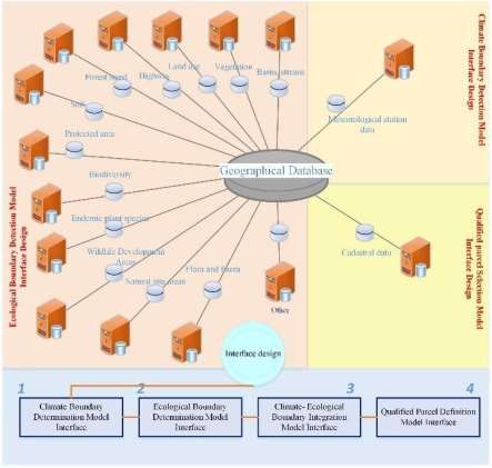
result, cadastral parcels that need to be protected are defined (Figure 1).
Figure 1. IKEKONIP Interface Model Design
IKEKONIP model consists of four sections. The first is the determination of climate
boundaries, the second is the determination of ecological boundary, the third is climate-
ecological boundary integration, and the fourth is the defining the quality of the parcel.
Through this interface, users can perform analyzes both individually and in connection with
each other. Different tools have been created to carry out these analyzes and are integrated
into the IKEKONIP. The application stages of the IKEKONIP interface model are as in
Figure 2.
Spatial Data
Spatial Model Design
Data Model Design for
for the
the Need
Need toto Identify
Identify Green
Green Property
Property Rights
Rights (10868)
(10868)
Tugba Memisoglu
Tugba MemisogluBaykal andand
Baykal H. Ebru ColakColak
H. Ebru (Turkey)
(Turkey)
FIG e-Working
FIG eWorkingWeek Week2021
2021
Smart Surveyors
Smart Surveyors for
for Land
Land and
and Water
Water Management - Challenges in a New Reality
Virtually in theChallenges
Management, Netherlands, 21–25
in A NewJune 2021
Reality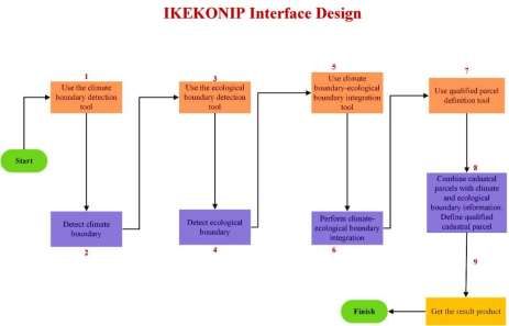
Figure 2. IKEKONIP interface design stages

            3.2. Climate Boundary Determination Model Interface Design Application Stage

   The climate boundary determination is the first part of the designed model. Through this
   designed interface, the user can choose any of the methods that he wants to make climate
   boundary determination. It can access the analysis results by defining the parameters suitable
   for the method of choice. In this section, climate classification methods for climate boundary
   detection are selected and integrated into the model interface (MGM, 2017). Model interface
   operation to be performed for the spatial data of climate boundary determination stage is
   shown in Figure 3.

Spatial Data
Spatial      Model Design
        Data Model Design for
                          for the
                              the Need
                                  Need toto Identify
                                            Identify Green
                                                      Green Property
                                                            Property Rights
                                                                     Rights (10868)
                                                                            (10868)
Tugba Memisoglu
Tugba   MemisogluBaykal  andand
                    Baykal    H. Ebru ColakColak
                                  H. Ebru      (Turkey)
                                                     (Turkey)

FIG e-Working
FIG  eWorkingWeek Week2021
                         2021
Smart Surveyors
Smart Surveyors for
                  for Land
                      Land and
                           and Water
                               Water Management - Challenges in a New Reality
Virtually in theChallenges
Management,      Netherlands, 21–25
                           in A NewJune  2021
                                     Reality
Figure 3. Climate Boundary Determination Model Interface Design
3.3. Ecological Boundary Determination Model Interface Design Application
Stage
The ecological boundary determination stage is the second part of the designed model.
Through this designed interface, the user can classify by selecting the spatial data to be
defined ecologically and can classify by selecting the attribute information. By combining all
the spatial data that it has classified, in a single pixel format, the resulting product can obtain a
surface raster map. Model interface operation to be performed for the ecological boundary
determination stage is shown in Figure 4.
Spatial Data
Spatial Model Design
Data Model Design for
for the
the Need
Need toto Identify
Identify Green
Green Property
Property Rights
Rights (10868)
(10868)
Tugba Memisoglu
Tugba MemisogluBaykal andand
Baykal H. Ebru ColakColak
H. Ebru (Turkey)
(Turkey)
FIG e-Working
FIG eWorkingWeek Week2021
2021
Smart Surveyors
Smart Surveyors for
for Land
Land and
and Water
Water Management - Challenges in a New Reality
Virtually in theChallenges
Management, Netherlands, 21–25
in A NewJune 2021
RealityFigure 4. Ecological Boundary Determination Model Interface Design
3.4. Climate- Ecological Boundary Integration Application Stage
Climate-ecological boundary integration is the third part of the designed model. Through this
designed interface, the user can combine the climate boundary map produced with the
ecological boundary map in the same pixel format and classify it by producing the resulting
product map. Model interface operation to be performed for the climate-ecological boundary
integration stage is shown in Figure 5.
Spatial Data
Spatial Model Design
Data Model Design for
for the
the Need
Need toto Identify
Identify Green
Green Property
Property Rights
Rights (10868)
(10868)
Tugba Memisoglu
Tugba MemisogluBaykal andand
Baykal H. Ebru ColakColak
H. Ebru (Turkey)
(Turkey)
FIG e-Working
FIG eWorkingWeek Week2021
2021
Smart Surveyors
Smart Surveyors for
for Land
Land and
and Water
Water Management - Challenges in a New Reality
Virtually in theChallenges
Management, Netherlands, 21–25
in A NewJune 2021
RealityFigure 5. Climate- Ecological Boundary Integration Model Interface Design
3.5. Qualified Parcel Definition Application Stage
Qualified parcel definition is the fourth and final application part of the designed model.
Through this designed interface, the user can produce the final surface map by matching the
integrated integrated surface raster map obtained in the third step with the cadastral parcel.
Thus, the definition of regions that change in the cadastral parcel can be realized. Model
interface operation to be performed for the qualified parcel definition stage is shown in Figure
6.
Spatial Data
Spatial Model Design
Data Model Design for
for the
the Need
Need toto Identify
Identify Green
Green Property
Property Rights
Rights (10868)
(10868)
Tugba Memisoglu
Tugba MemisogluBaykal andand
Baykal H. Ebru ColakColak
H. Ebru (Turkey)
(Turkey)
FIG e-Working
FIG eWorkingWeek Week2021
2021
Smart Surveyors
Smart Surveyors for
for Land
Land and
and Water
Water Management - Challenges in a New Reality
Virtually in theChallenges
Management, Netherlands, 21–25
in A NewJune 2021
RealityFigure 6. Qualified Parcel Definition Applicaiton
4. CONCLUSION
In Turkey, information on cadastral parcels is handled in two different structures, such as land
registry information and cadastral information. Therefore, the property owner cannot access
simultaneously many written registered information that both the geometric shape of the
terrain and the existing restrictions / constraints. However, in case of any situation related to
property, it is important that all existing limitations, restrictions, along with the geometric
dimension of the property can be accessed quickly and easily. In this study, the interface
spatial model design, in which qualified parcel definition depending on climate-ecological
boundaries in accordance with GIS technology will be defined, is discussed and modeled.
Using these models, the interface spatial model design will be carried out and analyzes can be
performed over an automated interface. This study includes a scope for the purpose of
defining the green property rights stated in Article 6 of Cadastre 2014 and after, and a spatial
Spatial Data
Spatial Model Design
Data Model Design for
for the
the Need
Need toto Identify
Identify Green
Green Property
Property Rights
Rights (10868)
(10868)
Tugba Memisoglu
Tugba MemisogluBaykal andand
Baykal H. Ebru ColakColak
H. Ebru (Turkey)
(Turkey)
FIG e-Working
FIG eWorkingWeek Week2021
2021
Smart Surveyors
Smart Surveyors for
for Land
Land and
and Water
Water Management - Challenges in a New Reality
Virtually in theChallenges
Management, Netherlands, 21–25
in A NewJune 2021
Realitydata model was designed with an exemplary application. This interface also developed can
provide backing to the work plans of the National Climate Strategy.
5. REFERENCES
Bennett R., 2014. Cadastre 2014: What lies beyond?, Cadastre 2014 and Beyond’un İçinde,
(Steudler D., Ed.), FIG Publication No 61, International Federation of Surveyors,
ss.54¬59.
Enemark, S., 2010. The Evolving Role of Cadastral Systems in Support of Good Land
Governance, The Digital Cadastral Map, FIG Commission 7 Open Symposium, Karlovy
Vary, Czech Republic.
Enemark, S., 2012a. From Cadastre to Land Governance, FIG Working Week 2012, Young
Surveyors Conference, May, Rome, Italy.
Kaufmann J. and Steudler, D., 1998. Cadastre 2014 – a vision for a future cadastral system,
FIG Publication, Rüdlingen and Bern, Switzerland, 38ss.
Kaufmann J., 2004. ArcGIS Cadastre 2014 Data Model Vision, ESRI, United States.
Meteoroloji Genel Müdürlüğü (MGM), 2017. İklim sınıflandırmaları,in Turkish.
Lemmens M., 2010. Towards Cadastre 2034, International Experts Speak Out, GIM
International, 24, 9.
Lemmens M., 2010a. Towards Cadastre 2034: Part II, International Experts Speak Out, GIM
International, 24, 10, October.
Tudes and Biyik, 1994. Kadastro Bilgisi Kitabı, Karadeniz Technical Universitesi,
Mühendislik Mimarlık Fakültesi, Karadeniz Teknik Üniversitesi Basımevi, Genel yayın
no: 174, Fakülte yayın no: 50, in Turkish.
Van Oosterom, P., Lemmen, C., Ingvarsson, T., van der Molen, P., Ploeger, H., Quak, W.,
Stoter, J. and Zevenbergen, J., 2006. The core cadastral domain model, Computers,
Environment and Urban Systems, 30, 627–660.
Yomralıoglu, T., Uzun, B. and Demir, O., 2003. Kadastro 2014 Gelecekteki Kadastral Sistem
İçin Bir Vizyon (Çeviri), 56 s., in Turkish.
BIOGRAPHICAL NOTES
H. Ebru ÇOLAK is Associate Professor at Karadeniz Technical University (KTU), Turkey.
She graduated from the Department of Geomatics Engineering at KTU in 2001. She received
her PhD degree with thesis entitled “Spatial analysis of cancer cases by Geographical
Information Systems in the Eastern Black Sea Region of Turkey” in January 2010. Her
research interests are Geographic Information Systems, Health GIS, Geostatistics and Land
Management.
Tugba MEMISOGLU BAYKAL is a Research Assistant at Artvin Coruh University and
now Visitor Research Assistant at Hacettepe University, Turkey. She graduated from
Department of Geomatics Engineering at KTU in 2007 and she became a master engineer
from the same department. She received her PhD degree in Department of Geomatics
Engineering in September 2021. Her interests are Geographic Information Systems,
Environmental GIS, Geostatistics and Land Management Applications.
Spatial Data
Spatial Model Design
Data Model Design for
for the
the Need
Need toto Identify
Identify Green
Green Property
Property Rights
Rights (10868)
(10868)
Tugba Memisoglu
Tugba MemisogluBaykal andand
Baykal H. Ebru ColakColak
H. Ebru (Turkey)
(Turkey)
FIG e-Working
FIG eWorkingWeek Week2021
2021
Smart Surveyors
Smart Surveyors for
for Land
Land and
and Water
Water Management - Challenges in a New Reality
Virtually in theChallenges
Management, Netherlands, 21–25
in A NewJune 2021
RealityCONTACTS
H. Ebru COLAK
Karadeniz Technical University
Faculty of Engineering
Department of Geomatics Engineering
Trabzon / TURKEY
Tel: +90 (462) 3773657
Fax: +90 (462) 3280918
e - mail: ecolak@ktu.edu.tr
https://aves.ktu.edu.tr/ecolak/
Tugba MEMISOGLU BAYKAL
Artvin Coruh University;
Hacettepe University
Faculty of Engineering
Department of Geomatics Engineering
Ankara / TURKEY
e - mail: tugbamemisoglu@artvin.edu.tr;
tugbamemisoglu@hacettepe.edu.tr
Spatial Data
Spatial Model Design
Data Model Design for
for the
the Need
Need toto Identify
Identify Green
Green Property
Property Rights
Rights (10868)
(10868)
Tugba Memisoglu
Tugba MemisogluBaykal andand
Baykal H. Ebru ColakColak
H. Ebru (Turkey)
(Turkey)
FIG e-Working
FIG eWorkingWeek Week2021
2021
Smart Surveyors
Smart Surveyors for
for Land
Land and
and Water
Water Management - Challenges in a New Reality
Virtually in theChallenges
Management, Netherlands, 21–25
in A NewJune 2021
RealityYou can also read