Spatial ecology of endangered roseate terns and foraging habitat suitability around a colony in the western North Atlantic
←
→
Page content transcription
If your browser does not render page correctly, please read the page content below
Vol. 44: 339–350, 2021              ENDANGERED SPECIES RESEARCH
                                                                                                    Published March 25
 https://doi.org/10.3354/esr01108                Endang Species Res

                                                                                                     OPEN
                                                                                                     ACCESS

      Spatial ecology of endangered roseate terns
    and foraging habitat suitability around a colony
              in the western North Atlantic
           Isabeau Pratte1,*, Robert A. Ronconi1, Shawn R. Craik2, Julie McKnight1
                    1
                      Canadian Wildlife Service, 45 Alderney Drive, Dartmouth, Nova Scotia B2Y 2N6, Canada
    2
        Université Sainte-Anne, Département des sciences, 1695 route 1, Pointe-de-l’Église, Nova Scotia B0W 1M0, Canada

         ABSTRACT: Predicting habitat suitability and understanding habitat utilization are important to
         inform and orient conservation and management decisions for the recovery of endangered spe-
         cies. In North America, the roseate tern Sterna dougallii is listed as endangered in both the north-
         eastern USA and Canada, where little is known about the foraging spatial ecology of the species.
         We equipped breeding roseate terns with miniature GPS tracking devices during incubation at
         North Brother Island, the main Canadian colony. Our aim was to characterize the spatial foraging
         ecology of the species, identify marine zones of importance, and develop a habitat suitability
         model around the colony. Our results provide novel, high resolution information on individual for-
         aging trips, notably showing that individuals restricted their range around the colony (15.4 km)
         while performing multiple foraging trips: up to 11 daytime trips and a maximum total of 152.9 km
         travelled per day. Roseate terns concentrated their foraging effort around the colony and further
         south along the coast to the Cockerwit Passage. Using distance from colony, sea surface tempera-
         ture, distance from land, bathymetry, and subtidal substrate type as covariates in a habitat suit-
         ability model, a high proportion of the deviance was explained (72.4%); the model also predicted
         high occurrence of foraging near the colony, in Cockerwit Passage, and at additional sites to
         which the birds were not tracked. Along with the description of important marine areas for roseate
         terns nesting on North Brother Island, this habitat suitability model provides a relevant and essen-
         tial context for understanding roseate tern habitat use in a broad sense, but with a focus on habitat
         requirements during incubation.

         KEY WORDS: Sterna dougallii · Individual movement · Habitat use · Incubation · North Brother
         Island · Nova Scotia

                    1. INTRODUCTION                              and endangered species (Jarnevich et al. 2016,
                                                                 Cañadas et al. 2018, García-Barón et al. 2019) and
  Habitat suitability models identify habitat require-           particularly for endangered seabirds, for which the
ments of species by modelling their functional                   study of spatial ecology is challenging (e.g. when a
response of occurrence or abundance in relation to               small sample of individuals is followed). Moreover,
habitat characteristics (Guisan & Zimmermann 2000,               habitat suitability modelling for endangered species
Aarts et al. 2008, Wakefield et al. 2011, Roberts et al.          can be valuable for making inferences about the spa-
2016, Warwick-Evans et al. 2018). Such modelling                 tial ecology of the species in other areas across its
approaches are useful for filling knowledge gaps                 range (Warwick-Evans et al. 2018), assessing the
regarding habitat use and selection by threatened                suitability of habitats in re-colonized areas (Cianfrani
                                                                 © Shawn R. Craik and Environment and Climate Change Canada
                                                                 2021. Open Access under Creative Commons by Attribution
*Corresponding author: pratteisabeau@gmail.com                   Licence. Use, distribution and reproduction are unrestricted.
                                                                 Authors and original publication must be credited.
                                                                 Publisher: Inter-Research · www.int-res.com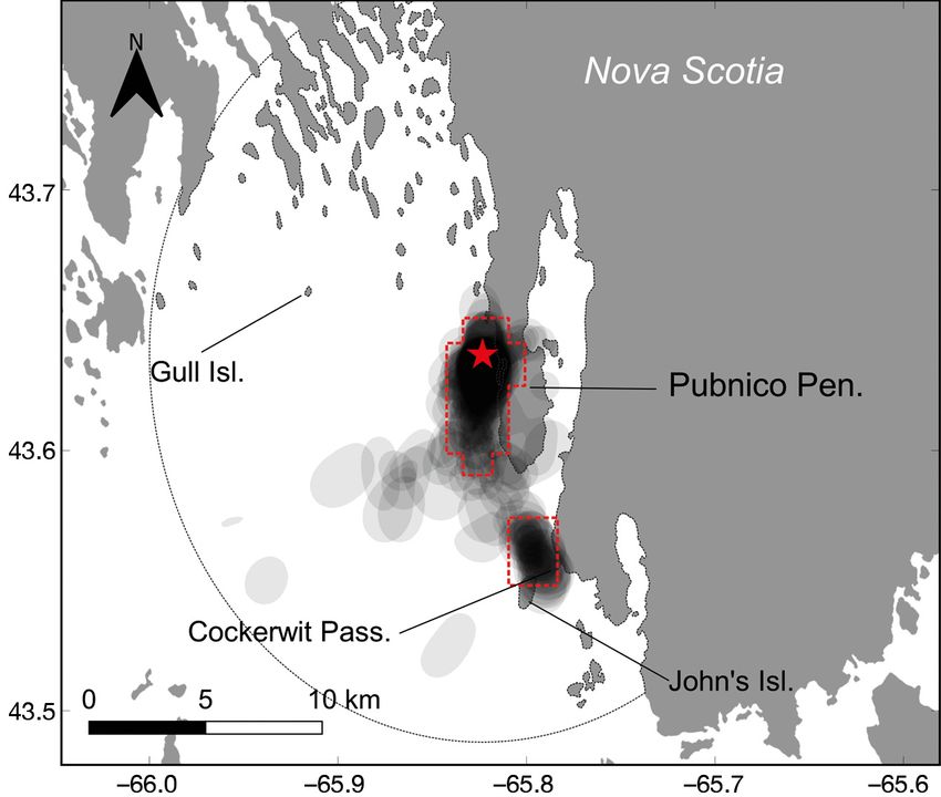
340                                     Endang Species Res 44: 339–350, 2021

et al. 2010), predicting where seabirds, for example,       breeding season; most information has comes from
may colonize in the future, or prioritising conserva-       VHF telemetry studies (Rock et al. 2007, Loring et al.
tion efforts such as habitat protection and restoration.    2019) or boat surveys (Perrow et al. 2011, Goyert
Understanding habitat utilization and predicting            2014, Robertson et al. 2014). Those studies corrobo-
habitat suitability is thus essential to inform and ori-    rated previous observations (Safina 1990, Monticelli
ent conservation and management decisions geared            et al. 2006) underlining the coastal behaviour of for-
toward the recovery of endangered species.                  aging roseate terns and their apparent preference for
   Seabirds are bound to their colony site for the dura-    shallow areas, especially in comparison to co-nesting
tion of the breeding season as they court, mate, lay        common and Arctic terns (e.g. Rock et al. 2007, Ro-
eggs, incubate, and feed their young in 1 location.         bertson et al. 2014). Advancements in tracking tech-
Thus, for nesting seabirds, the habitat available is        nologies have led to the development of smaller and
basically circumscribed by the maximum range of             lighter devices, enabling the collection of fine-scale
individuals while foraging at sea (Thaxter et al.           movement data to investigate habitat use and spatial
2012). However, within that maximum range, habitat          ecology of relatively small species such as roseate
can be used heterogeneously based on the availabil-         terns (e.g. Soanes et al. 2015).
ity of preferred prey, which is driven by ocean char-          Roseate terns currently breed at 3 sites in Canada,
acteristics, and on prey accessibility, which, in turn,     all 3 of which are in Nova Scotia: North Brother
is determined by foraging tactics. For seabirds, dis-       Island, Country Island, and Sable Island (see Fig. 1). A
tance from land, bathymetry, ocean fronts, and sea          previous study conducted at Country Island using
surface temperature (SST) (Louzao et al. 2006, Wake-        VHF telemetry revealed that most tagged birds for-
field et al. 2011, 2017, Soanes et al. 2016) are among       aged close to land in shallow water (< 5 m), typically
those habitat characteristics considered as proxies         within 7 km of their colony (Rock et al. 2007). Sample
for prey availability and occurrence, and they thus         size in that study was small and did not allow for de-
serve as useful correlates for explaining the distribu-     tailed characterization of foraging trips, as extensive
tion and occurrence of foraging seabirds.                   effort is required to track birds using VHF telemetry.
   The roseate tern Sterna dougallii has an almost             North Brother Island is located 375 km to the
cosmopolitan breeding distribution, abundant in the         southwest of Country Island in Lobster Bay, and cur-
tropics and fragmented in the North Atlantic Ocean.         rently supports ~75% of the Canadian roseate tern
In the North Atlantic, adult survival rate and genetic      population. The island is small (0.2 ha) and located
diversity are low compared to other seabird species         within 700 m of the mainland (see Fig. 1). Marine
with comparable life-history characteristics (Nisbet &      habitat use by roseate terns nesting at this site has
Ratcliffe 2008). The western North Atlantic popula-         never been quantified. With the aim of qualifying
tion (subspecies S. d. dougallii) is listed as endan-       and quantifying habitat characteristics and marine
gered in both Canada and the USA (COSEWIC 2009,             areas of primary importance for foraging roseate
US Fish and Wildlife Service 2010). The historical          terns breeding on North Brother Island, we equipped
population size in northeastern North America was           nesting roseate terns with small GPS tracking de-
estimated at 8500 pairs (1930s; Nisbet et al. 2014);        vices to obtain fine-scale at-sea movement data asso-
however, the plume trade for the millinery industry         ciated with foraging trips. Currently, new develop-
led to the near extirpation of the population in the        ment for aquaculture infrastructure is being assessed
late 19th century (< 2000 individuals). The most cur-       in the Lobster Bay area, though the bay is already
rent estimate of 4274 pairs (2019; Canada and the           subject to a range of anthropogenic stressors includ-
USA) represents a slight increase since the late 1970s      ing, among others, rockweed Ascophyllum nodosum
(2500 pairs; Nisbet et al. 2014). However, this in-         harvesting, activities relating to commercial fishing
crease has been driven by population growth in the          (e.g. vessel traffic, harbours, effluent from fish pro-
US colonies, whereas low productivity and habitat           cessing plants), and the associated risk of oil spills.
degradation are thought to be limiting the growth of        Given this range of coastal development stressors,
Canadian colonies (COSEWIC 2009), with peak                 defining foraging habitat for this endangered and
breeding numbers of 69 pairs in 2019. In the western        restricted population has important implications for
North Atlantic, roseate terns always nest with com-         conservation planning in this region
mon terns S. hirundo and occasionally with both                Specifically, we aimed to (1) identify marine zones
common and Arctic terns S. paradisaea (Donehower            of relatively high use, (2) assess population-level
et al. 2007). Little is known about the movements and       fidelity to those zones, and (3) assess preferred habi-
habitat use of foraging roseate terns during the            tat characteristics to develop a predictive model for
Pratte et al.: Tracking roseate terns in Nova Scotia                                  341

foraging roseate terns. Using this habitat suitability            n = 7) breeding seasons. No tags were retrieved
model, we describe important marine areas for rose-               during 2017 due to colony abandonment following
ate terns nesting on North Brother Island located                 high nest depredation (J. McKnight pers. obs.). In
within Lobster Bay. The development of a habitat-                 2016, we recaptured 8 birds (7 tags) after 6 d of de-
based model targeting foraging terns’ occurrence in               ployment during which the tags recorded positions
waters near established colonies or newly formed                  every day. We suspected the remaining 6 tags fell off
colonies in Atlantic Canada will help guide manage-               following suture wear, as we saw no birds carrying
ment and conservation decisions relating to the spe-              tags during subsequent tag retrieval trips to the
cies’ recovery (Environment Canada 2014).                         island. Thirteen of the 14 nests incubated by tagged
                                                                  birds hatched (93%); 1 nest was abandoned, although
                                                                  the adult was re-sighted on Country Island that sum-
          2. MATERIALS AND METHODS                                mer and later that year in Cape Cod. Out of 48 con-
                                                                  trol nests with no adults tagged, 75% hatched (n =
              2.1. Study site and capture                         36), 19% failed (n = 9), and the fate was unknown for
                                                                  6% (n = 3). These apparent differences between
  Roseate terns Sterna dougallii were captured at                 groups were not significant (chi-squared test; χ2 = 2.23,
North Brother Island (43.6364° N, 65.8235° W), Nova               df = 2, p = 0.33). Tags recorded locations when more
Scotia (Fig. 1). North Brother is a managed colony                than 3 satellites were available. Terns plunge-dive
with measures in place to support roseate tern nest-              from various heights to capture small fish, and are gen-
ing, including the instalment of 50−150 nest shelters             erally thought to forage during daylight hours. Each
on suitable nesting substrate (e.g. cobble) each year.            tag was thus set to record GPS locations at 15 min
Adult roseate terns were trapped on their nests dur-              intervals and was set off-duty between 01:00 and
ing the incubation period using modified potter                   08:00 h UTC, except for one individual (rt14) that was
trap/walk-in treadle traps. PathTrack© nanoFix-GEO                also tracked at night to explore the possibility that
GPS tags (2.5 g) were attached to the interscapular               individuals in this population forage nocturnally.
region using Tesa tape and subcutaneous suture
thread (Loring et al. 2017). All trapping and tag
attachment methods were undertaken according                                          2.2. Data analysis
to Animal Care permit #16JMK02, 17JMK02, BBO
#10745 (and associated Canadian Wildlife Service                              2.2.1. Identifying foraging trips
Scientific permit ST2714 in addition to provincial en-
dangered species permits). We deployed tags in both                 To assess foraging behaviour using the residence
the 2016 (16 and 17 June, n = 14) and 2017 (15 June,              in space and time method (RST; Torres et al. 2017;

Fig. 1. The 3 major roseate tern colonies in Canada: North Brother Island, Country Island, and Sable Island, as well as general
areas where roseate terns nest in the USA (circles). Right panel: close-up view of the area around North Brother Island (black
               star) with bathymetry contour lines at 10 m depth intervals. Projection: WGS84 Pseudo-Mercator
342 Endang Species Res 44: 339–350, 2021
see also next section), we first regularized positions radius, i.e. the one where all points have at least one
for each individual track at 5 min intervals (Ben- other point inside its circle. In our case, we tested for
hamou & Riotte-Lambert 2012) using the package radii 50−500 m at 10 m intervals, and radii 1−15 km at
‘adehabitatLT’ (Calenge 2006) in program R (R Core 500 m intervals; see Torres et al. (2017) for a detailed
Team 2020). Next, each individual track was split description of the RST method. The RST method
into foraging trips according to the distance travelled enabled us to exclude locations categorized as rest-
from the colony and the time spent away from the ing and travelling from the remaining analysis of
colony (Lascelles et al. 2015). Only travelling move- habitat use and habitat modelling. We further used
ment away from the colony beyond a 100 m buffer foraging locations (i.e. ARS) to assess habitat use and
and lasting more than 15 min was considered a for- to develop our habitat suitability model for roseate
aging trip. An individual was considered to have terns.
returned when the distance from the colony in an
identified trip passed a threshold of 150 m toward the
colony. For example, if a bird departed the colony 2.2.3. Habitat use
(and passed the 100 m buffer for more than 15 min)
and one of the subsequent locations when consid- We used the marine Important Bird and Biodiver-
ered sequentially fell within the return threshold of sity Areas (mIBA) protocol developed by Lascelles et
150 m, then its travelling movement was considered al. (2015) to identify important areas of utilization for
a finite foraging trip. We chose these thresholds roseate terns. Namely, we used kernel density esti-
through visual examination of the data to ensure mator to identify the core utilization areas (50% uti-
buffers allowed the identification of travelling move- lization distribution, UD) for each individual foraging
ment away from the colony while also correctly iden- trip using the ‘kernelUD’ function from the R pack-
tifying unique trips. By doing so, we excluded from age ‘adehabitatHR’ (Calenge 2006). We followed the
this study foraging activity known to happen very method by Lascelles et al. (2015) to estimate the
close to the colony (a few meters from shore and last- smoothing term h used in the kernel density calcula-
ing less than 15 min; S. R. Craik pers. obs.). Such tion. This method uses first passage time (FPT) analy-
activity would have been hard to characterize given sis at different scales on each trip for each individual
the temporal resolution of the GPS devices. Regard- tracked, and identifies the scale at which each trip
less, the exclusion of this data likely did not influence interacts with the environment based on the maxi-
the conclusions of the study, given that foraging trips mum variance in FPT value found across the tested
within 100 m of the colony are not common (S. R. scales. We tested scales of different radius from
Craik pers. obs.) 500−5000 m at 100 m intervals, between 6 and 10 km
at 1 km intervals, and between 11 and 15 km (the
maximum distance for a trip) at 2.5 km intervals. This
2.2.2. RST method returns the median scale for each individ-
ual, and we used the average of that median across
We used the RST method (Torres et al. 2017) to dis- individuals as the value of h in the kernel density cal-
criminate 3 behaviours: (1) travelling, (2) area restric- culation (h = 0.85 km). We estimated core areas of
ted search (ARS) associated with foraging activity, each individual trip by using the average h found
and (3) resting. The RST method enabled us to asso- across individuals to facilitate the population esti-
ciate each at-sea location as regularized (above) with mate of spatial aggregation and area of concentrated
one of the 3 behavioural states based on the distance use obtained as follows. We assessed the ‘spatial
travelled within a radius and the time spent in that aggregation’ of each individual foraging trip core
radius. For a location to be considered as resting, area (50% UD overlap) using Bhattacharrya’s affinity
time spent in a radius around the location must be index (BA). The spatial aggregation corresponded
sufficiently long and the distance travelled short to the median of all the pairwise BA overlap across
(time intensive). For ARS, both time spent and dis- all trip core areas for all individuals. In other words,
tance travelled in the radius must be relatively long ‘spatial aggregation’ is an index of repeated use of
(time and distance intensive). For travelling, time an area across all birds. We also calculated the area
spent and distance travelled would be minimal in of concentrated use for all birds, which corre-
order to cross a given radius. We selected the radius sponded to areas where more than 12.5% of the core
for each individual based on the diagnostic tool pro- areas occurred (Lascelles et al. 2015, Oppel et al.
vided by Torres et al. (2017), which identifies best 2018), i.e. grid cells that intersected with at leastPratte et al.: Tracking roseate terns in Nova Scotia 343
12.5% of the core areas (Lascelles et al. 2015). Grid variable improved the area under the receiver op-
cell size corresponded to h divided by 100. For each erating curve (AUC) score, helped reduce the AIC
individual, we further calculated the recursion of for- score, and increased the percentage of explained
aging trip within the area of concentrated use deviance. We used the AUC score as a diagnostic
defined within the Cockerwit Passage (Fig. 1). measure of our final model over 10-fold cross valida-
tion (with AUC = 0.5 meaning no better than random,
and AUC = 1 meaning model with perfect fit).
2.2.4. Habitat modelling We used our final model to predict the probability
of occurrence of foraging roseate terns around North
Within the maximum foraging range observed Brother Island for the study period within an area
from North Brother Island (15.4 km), we randomly corresponding to the maximum foraging range
resampled background points (pseudo-absence), around the colony. We divided the maximum forag-
excluding land and excluding a 100 m buffer around ing range into a grid of 850 × 850 m squares, and at
each observed foraging location, in order to compare each grid square centroid, covariates were extracted
characteristics of the locations used by the terns (true and used as the predictor data frame; average daily
presence) from the randomly sampled background SST over the study period was calculated as indi-
points. For each observed foraging location, we ran- cated above. HSI ranged from 0−1 and represents
domly sampled 3 background points (total of 4635 the predicted probability of occurrence of foraging
pseudo-absence points). Five characteristics were roseate terns.
measured at each location: distance to the colony
(dist2col), distance to the nearest land including
islands (dist2land), daily SST (°C) averaged over the 3. RESULTS
6 d of the tracking study, water depth (ETOPO1, spa-
tial resolution of 0.03°, approximately 3 km; vertical Seven roseate terns Sterna dougallii nesting on
resolution of approximately 10 m), and subtidal sub- North Brother Island were tracked during the incu-
strate type (Greenlaw et al. 2013). SST data were bation period, resulting in 42 bird-tracking days and
Multi-scale Ultra-high Resolution (MUR) downloaded 4435 GPS points. We identified 270 trips at sea
from https://coastwatch.pfeg.noaa.gov/erddap (spa- (Table 1). Roseate terns from North Brother Island
tial resolution of 0.01°). The subtidal substrate types travelled up to 152.9 km in a single day, which repre-
included boulders, mixed sediments, mud, sand, sents 11 daytime foraging trips. The maximum range
sand/gravel, and sand/mud. among individuals for a trip varied between 100 m
To obtain a habitat suitability index (HSI), we used and 12.6 km (Table 1, Fig. S1 in the Supplement at
a generalized additive model (GAM; package ‘mgcv’ www.int-res.com/articles/suppl/n044p339_supp.pdf).
in R) with a binomial distribution; a value of 1 was The total distance travelled during a trip was as short
given to observed locations and 0 to randomly sam- as 230 m and as long as 32.3 km (Fig. S2). The longest
pled background points. We created single variable trip lasted 170 min (excluding night trips [n = 3]
models for each of the 4 continuous covariates as of rt14; Table 1). Considering the 267 daytime forag-
smooth terms, with the number of knots (k) initially ing trips across all individuals, the average (± SE)
set to 3, and using cubic regression spline to reduce maximum range was 4.6 ± 0.2 km trip−1, with the
model overfitting (Wood 2006). We further adjusted average trip lasting 49 ± 2 min and totalling 10.9 ±
the number of k for each smooth term to obtain a bet- 0.5 km. As has been shown elsewhere, we did not iden-
ter fit according to the percentage of deviance ex- tify daytime resting on the sea (red dots in Fig. S1).
plained and reduction of Akaike’s information crite- Roosting behaviour was limited to the vicinity of
rion (AIC) scores of single variable models. We the colony (Fig. S1). In general, terns appeared
limited k to 7 to limit overfitting models and ease active throughout the day, with slightly lower num-
model interpretation (Wood 2006). The final model bers of departing trips at mid-day and relatively
included all 4 continuous covariates in addition to higher activity near sunrise (Fig. S3). We identified
substrate type. Given that our goal was to obtain the 3 nocturnal trips from rt14 occurring during 3 dif-
best predictive model rather than finding which ferent nights (Text S1) with maximum distances of
environmental variables were more important for 300 m, 13.7 km, and 15.4 km and respective dura-
roseate tern foraging occurrence, all variables were tions of 20 min, 4.5 h, and 6.8 h. RST analyses sug-
included in the final model with disregard for poten- gest that the purpose of the night travel was different
tial correlation between them. The addition of each from that observed during daylight hours and in-344 Endang Species Res 44: 339–350, 2021
Table 1. Foraging trips of 7 roseate terns tracked from 16−23 June 2016 during the incubation period at North Brother Island,
Nova Scotia, Canada. All data are from daytime trips except rt14, which includes tracking for 24 h. The right-hand column
presents the number of each individual’s foraging trip revisits (and associated proportion over all foraging trips) to the area of
concentrated use defined in Fig. 2 in the Cockerwit Passage
Bird ID Maximum range Total distance Duration No. of Tracking No. of revisits
(km) (km) (min) trips duration to Cockerwit
Mean Range Mean Range Mean Range Pass. area
rt14 5.2 0.3−15.4 12.7 0.5−31.5 61.0 20−405 46 17−23 June 8 (0.19)
rt15 5.9 0.4−9.4 13.4 0.8−25.0 50.4 20−145 26 17−23 June 8 (0.31)
rt17 5.5 0.6−9.9 12.9 1.2−32.3 49.5 20−105 33 17−23 June 19 (0.58)
rt19 5.0 0.2−12.6 11.2 0.5−31.9 42.6 20−90 38 17−23 June 9 (0.23)
rt21 3.9 0.2−9.9 8.9 0.4−21.3 39.7 20−85 35 17−23 June 7 (0.20)
rt22 3.9 0.1−9.0 8.8 0.2−19.3 43.1 20−85 37 16−22 June 6 (0.16)
rt30 3.7 0.3−9.3 9.4 0.6−28.7 53.7 20−170 55 16−22 June 4 (0.07)
cluded resting periods while at sea
and travel interspaced with foraging
bouts (Text S1).
The spatial aggregation (BA index)
at the population level was 64%, indi-
cating moderately high similarity in
space use among individuals. The
size of the area of concentrated use
reached 7.1 km2 when considering a
minimum overlap of 12.5% in the core
areas across trips by all individuals.
This area was located mostly around
and to the south of the colony and in-
cluded the Cockerwit Passage (Fig. 2),
a shallow zone of sand and gravel with
a rocky bar joining John’s Island. All
individuals revisited this area, some
more frequently than others: 58% of
foraging trips made by rt17 were to
Cockerwit Passage, compared to only
7% for rt30 (Table 1).
Our final GAM AUC score was 0.98,
with the model explaining 72.4% of Fig. 2. Core foraging areas (50% utilization distribution [UD]; transparent
the deviance, indicating good model polygons) calculated based on the foraging locations (residence in space and
fit. Relative habitat suitability over the time method > 0; blue dots in Fig. S1) of each roseate tern foraging trip tracked
during incubation (16−23 June 2016) at the North Brother Island colony. The
tracking study was mostly influenced
smoothing term h (0.85 km) corresponds to the average of each individual h
by distance from the colony. Roseate calculated previously to facilitate and enable comparison of all individuals’
terns’ occurrence decreased with dis- UDs. Red dashed boxes (grid size = h / 100): ‘areas of concentrated use’ esti-
tance from the colony and distance to mated following the marine Important Bird and Biodiversity Areas approach
nearest land as they showed a prefer- (Lascelles et al. 2015) for all individuals (i.e. where at least 12.5% of all core
areas overlapped); black dotted line: maximum range reached for a foraging
ence for areas relatively close to shore trip (15.36 km). Projection: WGS84 Pseudo-Mercator
(Pratte et al.: Tracking roseate terns in Nova Scotia 345
Fig. 3. Model terms for estimated probability of occurrence of
foraging roseate terns breeding at North Brother Island, No-
va Scotia. The y-axis represents the term’s function with the
effective degrees of freedom of the smooth terms in brackets;
0 on the y-axis corresponds to absence of effect of the pre-
dictor variable on the estimated probability of occurrence.
Terms included in the generalized additive model were dis-
tance to colony (dist2col; m), average sea surface temperature
(average_SST;°C), distance to nearest land (dist2land; m),
bathymetry (m), and substrate type (5 categories); y-axis
scale is varied to emphasise model fit. Confidence intervals
(dashed lines) are shown at 5 SE above and below the esti-
mate of the smooth, or the parametric coefficient estimate for
substrate, using ‘Mud’ as the reference level
sented 40% of the study area at 318 km2, while 2017 following abandonment of North Brother Island
sand/gravel and sand/mud together totalled 23% of (see Section 2.1) (Fig. 4).
the study area at 184 km2 (Fig. S4). Areas with bot-
tom substrate consisting of only sand did not appear
suitable for foraging terns (Fig. 3), despite this type of 4. DISCUSSION
substrate covering 27% of the study area (216 km2;
Fig. S4). Habitat suitability modelling revealed that a Understanding endangered seabird spatial ecol-
relatively high occurrence of foraging terns was pre- ogy and habitat use can be challenging because
dicted for areas around the colony and farther south researchers are often limited by small sample sizes.
along the Pubnico Peninsula to the Cockerwit Pas- The roseate tern Sterna dougallii is listed as endan-
sage and west towards nearshore areas of Gull gered in Canada, where the small breeding popula-
Island, the island which roseate terns colonized in tion (69 pairs in 2019) is generally restricted to 3346 Endang Species Res 44: 339–350, 2021
Table 2. Generalized additive models built with single covariates (upper section of table) and forward step-wise model selec-
tion procedure to assess multiple covariate models (lower section of table). Number of knots used in the smooth function (k),
percentage of model deviance explained, and area under the curve (AUC) are presented. The model in bold is the final model
selected based on increase in AUC score and percentage of deviance explained, and a decrease in Akaike’s information cri-
terion (AIC) score following the successive addition of each covariate. Dist2col: distance to colony; SST: sea surface tempera-
ture; dist2land: distance to nearest land
Covariate k % dev. AUC
Dist2col 5 55.4 0.92
SST 4 34.8 0.87
Dist2land 6 18.7 0.78
Bathymetry 3 8.0 0.69
Substrate na 16.1 0.46
Model AIC % dev. AUC
Presence ~ s(dist2col) + s(SST) 2437 63.8 0.95
Presence ~ s(dist2col) + s(SST) + s(dist2land) 2008 70.4 0.97
Presence ~ s(dist2col) + s(SST) + s(dist2land) + s(bathymetry) 1952 71.3 0.97
Presence ~ s(dist2col) + s(SST) + s(dist2land) + s(bathymetry) + substrate 1819 72.4 0.98
the covariates included in our habitat
suitability model was high, thus pro-
viding a useful context for under-
standing patterns of resource use and
predicting suitable foraging habitat
for endangered roseate terns around
their colony.
4.1. Spatial ecology
Roseate terns breeding on North
Brother Island made foraging trips
throughout the day; the high number
of trips per day corroborates the fre-
quent shifts in incubation bouts ob-
served for the species (Nisbet et al.
2014). Similar to previous studies on
roseate terns (mostly using VHF or at-
sea obser vations; Rock et al. 2007,
Robertson et al. 2014), we found that
individuals from North Brother Island
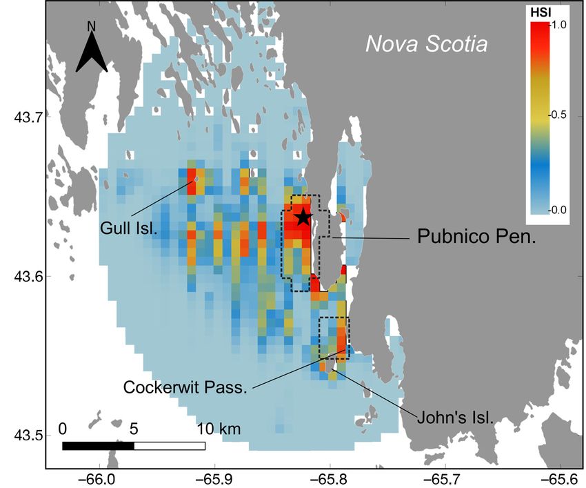
Fig. 4. Spatial predictions of habitat suitability index (HSI; probability of restricted their foraging range to
occurrence) over the period of the tracking study per 850 × 850 m grid square, around their breeding colony (Rock
where 1 is the greatest suitability and 0 is not suitable. Model is based on for- et al. 2007), travelling an average of
aging locations and randomized background points within the maximum for-
aging range observed for roseate terns tracked form North Brother Island 4.6 km from the island and never ex-
(black star). Black dashed boxes: ‘areas of concentrated use’ described in Sec- ceeding 16 km. These findings sup-
tions 2.2.3 and 3 (Fig. 2). Projection: WGS84 Pseudo-Mercator port the idea that such a restricted
range might be characteristic of the
islands. In 2016, we tracked 7 adult roseate terns North Atlantic roseate tern population (Rock et al.
over 1 wk during the incubation period. Birds origi- 2007), as has been found in some European colonies
nated from a colony at which ~75% of the Canadian (Robertson et al. 2014). In contrast, the species has
population currently breed. The level of response to been observed to venture as far as 60 km from thePratte et al.: Tracking roseate terns in Nova Scotia 347 colony in the tropics (Surman & Wooller 2003). In data on prey deliveries at this colony. Sand lances are their North Atlantic range, roseate terns are gener- the main food source brought to chicks at the other ally much more specialized in their diet than com- Canadian colony, Country Island (Rock et al. 2007), mon S. hirundo and Arctic S. paradisaea terns, which and presumably roseate terns from North Brother rely on fewer prey species and specialize mostly on have a similar diet. Cockerwit Passage could thus sand lance Ammodytes spp. (Safina 1990, Rock et al. represent the closest site from the colony with likely 2007, Nisbet et al. 2014). The distance travelled by abundance of sand lances, and the availability of roseate terns should reflect where important prey these fish could help explain the recurrent use of this species are available, and central-place foraging the- site by all tracked birds, although some individuals ory predicts that these birds should select areas of visited more consistently than others. Similarity in sufficient food that are closest to the colony (Elliott et habitat use among individuals can be expected in a al. 2009). specialist species, but exploiting a narrow ecological The only individual tracked at night (rt14) dis- niche can come at the cost of flexibility (Bolnick et al. played intriguing nocturnal activity during 3 out of 2003). For example, specialist species are predicted the 6 nights it was tracked. The bird travelled about to be more vulnerable to habitat and climate changes 15 km west of the colony and rested for several hours (Davies et al. 2004, Durner et al. 2009, Clavel et al. (likely on shoal or exposed rock), although some for- 2011, Trivelpiece et al. 2011). Nonetheless, this study aging activity was also identified by the RST method. presents tracking data from only 1 wk during the in- We suggest here that roseate terns can also engage in cubation phase; thus, similarity in habitat use and foraging activity at night. Though nocturnal activity how this may relate to specialization should be con- was observed in this particular bird, such nighttime sidered with caution as prey availability and ener- travel was not deemed the norm, as it did not happen getic demands of terns may vary among breeding every night rt14 was tracked, nor was it frequent phases (Safina & Burger 1985) and years. during those nights (1 trip night−1). Nonetheless, noc- turnal trips may be relatively common; thus, future tracking efforts should include the full 24 h cycle. 4.2. Habitat modelling Spatial aggregation among individuals was high, reaching 64% overlap, indicating high degree of sim- Distance from the colony, SST, distance from near- ilarity in space use among individuals. Such aggrega- est land, bathymetry, and subtidal substrate type tion levels likely correspond to predictable forage predicted the occurrence of foraging roseate terns linked to environmental characteristics such as sand- during incubation. The level of response of tern bars, shallow reefs and shoals that, with the con- occurrence to the 5 predictors was high, with an comitance of tidal currents, can help concentrate explained model deviance of 72.4%, though some fish prey and render them more accessible to terns. variables had more predictive power than others. Roseate terns associate with such features, notably The order to which the variables entered the model where they breed in the western North Atlantic (e.g. (based on AUC score) revealed that roseate terns, Long Island, NY; Safina 1990). The birds from North like other central place foraging seabirds, are strongly Brother Island exhibited concentrated use in the bound to their breeding colony. Although roseate Cockerwit Passage, located to the south east of the terns are known coastal foragers, specializing in colony and characterized by shallow waters with the use of shallow-water submerging sandbars, tide strong tidal currents, a narrow passage correspon- rips, and shallow reefs (Safina 1990, Rock et al. ding to typical roseate tern foraging habitat (Safina 2007, Robertson et al. 2014), bathymetry did not 1990, Nisbet et al. 2014). The bottom substrate on the explain a large amount of the deviance of our data, eastern shore of John’s Island in the Cockerwit Pas- and only slightly improved the overall fit of the sage includes a mix of sand and gravel, which is typi- model. Roseate terns often occurred at shallow loca- cal sand lance habitat (Haynes et al. 2007, Staudinger tions (< 20 m depth), but sometimes used sites with et al. 2020). Indeed, observations undertaken from a greater depth (> 50 m depth). The species has been boat during the study period confirmed that groups of observed to forage along exposed coastlines and up to 2−3 roseate terns fed on sand lances at this site inshore shallow areas while also making use of deep during breeding (S. R. Craik unpubl. data), and in waters, especially in its more tropical breeding loca- some years, sand lances are routinely brought back to tions (Shealer 1998, Ramos 2000, Surman & Wooller North Brother Island during courtship and chick- 2003, Monticelli et al. 2006). However, the lesser feeding activities. However, we lack quantitative importance of bathymetry in this study could be
348                                     Endang Species Res 44: 339–350, 2021

related to the resolution of that data layer (which was     wit Passage. This mirrors the area of concentrated
coarse considering the local scale at which terns are       use identified above (Fig. 4). Suitable habitat was
foraging) and/or to the scarcity of sample points at        also identified at a few smaller sites west of the
greater depth and at shallower depth.                       colony, in particular around Gull Island, which is of
   Foraging roseate terns occurred at relatively warm       interest given that the terns colonised this site in
SST, which could be linked to shallower and more            2017 following abandonment of North Brother Is-
coastal waters. However, this functional response is        land. Such concomitance suggests that predicting
less clear to interpretation given the small range of       suitable foraging habitat for the roseate tern, in the
temperatures observed at the time of the study,             context of the establishment of additional managed
which spanned between 10.6 and 11.0°C. Given that           colonies, could be useful in determining other poten-
North Brother Island is located within a bay, prefer-       tial breeding sites within their actual at-sea domain.
ence for warmer SST could be the result of the              However, manual tracking of this species by boat in
localised foraging behaviour of the terns within this       recent years (S. R. Craik unpub. data) suggests that
more enclosed system close to the coast. Despite the        the shorelines of this island are not important for
narrow range of temperatures observed, SST con-             feeding terns during the breeding season. Presum-
tributed greatly in improving model fit. Similar to         ably, some features, key in the distribution of pre-
bathymetry, response to distance to nearest land was        ferred prey, may not be present at all sites deemed
present but not as important as distance from colony        suitable by the model (e.g. currents). Thus, care
and SST. Nonetheless, the response trajectory was           should be taken when interpreting some of the
consistent with the known coastal foraging behav-           model results. Subsequent telemetry studies and/or
iour of roseate terns (Rock et al. 2007, Robertson et       boat-based work may validate these predictive re-
al. 2014); terns chose areas closer to land and were        sults, but also enhance our understanding of habitat
unlikely to venture very far offshore.                      association at this colony. Roseate tern abundance at
   The probability of occurrence for the roseate tern       sea has been observed to correlate with prey avail-
was highest over substrate types consisting of boul-        ability (Safina 1990) and also with the abundance of
ders, sand/mud, and sand/gravel. Sand/gravel sub-           common terns at sea (Goyert 2014), 2 variables that
strate has been shown to be a favourable habitat for        we could not directly quantify in our tracking study
sand lances (Staudinger et al. 2020). Rock boulders         but that could greatly refine our understanding of
are essential substrate for rockweed Ascophyllum            habitat associations for the species at this colony.
nodosum, which creates nursery habitat for many fish           Given the species’ small, restricted population and
species such as Atlantic herring Clupea harengus.           the logistical difficulties in studying movement of
Sand lances have also been found in abundance in            sensitive and endangered species, we provide novel
rockweed habitat on the South shore of Nova Scotia          information concerning their spatial ecology and the
(Vercaemer et al. 2018). We lack feeding observa-           first applicable tool to model response to habitat char-
tions to quantitatively validate the presence of first      acteristics of foraging roseate terns during the breed-
age class herring in the terns’ diet at this colony, but    ing season in the western North Atlantic. This new
roseate terns have been observed carrying this prey         information could be used to better guide conserva-
item in this area (S. R. Craik pers. obs.). The rich bio-   tion and management decisions at local and regional
genic habitats growing over rock boulders combined          scales (e.g. Lieske et al. 2020), especially given the
with the restricted coastal range of the roseate tern       gaps in knowledge of at-sea habitat use that currently
might explain the higher predicted foraging occur-          exist for this species, especially in Canada. Modelling
rence over such habitats, as these were predominant         terns’ habitat suitability at sea can help researchers
around the colony (Fig. S4). Given that rockweed is a       provide advice for environmental assessments con-
resource harvested in the area, our results suggest         cerning project developments in marine and coastal
that the potential impacts of such an industry on           ecosystems. Moreover, understanding marine habitat
roseate tern foraging habitat should not be over-           requirements for breeding roseate terns can help
looked. Further study is required to understand the         identify other candidate sites, which is important
mechanistic link between terns, their prey, and the         since the establishment of new breeding colonies is a
habitats that provide foraging opportunities.               stated goal of the recovery strategy for this species in
   At North Brother Island, predictions of relative         Canada (Environment Canada 2014). Lastly, our mo-
habitat suitability revealed high probabilities of          del should be interpreted in light of the known local
occurrence around the breeding colony, and to the           distribution of the species, given that assessing the
south around the Pubnico Peninsula and the Cocker-          temporal variation in habitat choice and in foraging
Pratte et al.: Tracking roseate terns in Nova Scotia                                 349

functional response that exists within and across                    seabird provides evidence for Storer-Ashmole’s halo.
breeding seasons is still necessary to help evaluate                 Auk 126:613−625
                                                                  Environment Canada (2014) Action plan for the roseate tern
the vulnerability of this endangered seabird to an-                  (Sterna dougallii) in Canada. Environment Canada,
thropogenic or climate-induced changes.                              Ottawa
                                                                  García-Barón I, Authier M, Caballero A, Vázquez JA, Santos
Acknowledgements. A particular thanks to everyone who                MB, Murcia JL, Louzao M (2019) Modelling the spatial
supported our work in the field, especially Ted D’Eon and            abundance of a migratory predator: a call for transbound-
Ingrid Pollet. Thanks to Karel Allard for his enlightening           ary marine protected areas. Divers Distrib 25:346−360
discussion about the marine habitats found in Lobster Bay.        Goyert HF (2014) Relationship among prey availability,
Thanks to the 3 reviewers whose comments helped im-                  habitat, and the foraging behavior, distribution, and
proved the final version of the manuscript. All capture and          abundance of common terns Sterna hirundo and roseate
tag attachment procedures were made in accordance to the             terns S. dougallii. Mar Ecol Prog Ser 506:291−302
Animal Care permit # 16JMK02, 17JMK02, Bird Banding               Greenlaw ME, Gromack AG, Basquill SP, MacKinnon DS
Office permit # 10745 (and associated Canadian Wildlife              and others (2013) A physiographic coastline classifica-
Service Scientific permit ST2714 and provincial endangered           tion of the Scotian Shelf bioregion and environs: the
species permits). This research was funded by Environment            Nova Scotia coastline and the New Brunswick Fundy
and Climate Change Canada.                                           shore. Can Sci Advis Secr Res Doc 2012/051
                                                                  Guisan A, Zimmermann NE (2000) Predictive habitat distri-
                                                                     bution models in ecology. Ecol Model 135:147−186
                   LITERATURE CITED                               Haynes TB, Ronconi RA, Burger AE (2007) Habitat use and
                                                                     behavior of the Pacific sand lance (Ammodytes hexa-
Aarts G, MacKenzie M, McConnell B, Fedak M, Matthio-                 pterus) in the shallow subtidal region of southwestern
    poulos J (2008) Estimating space-use and habitat prefer-         Vancouver Island. Northwest Nat 88:155−167
    ence from wildlife telemetry data. Ecography 31:140−160       Jarnevich CS, Holcombe TR, Grisham BA, Timmer J and
Benhamou S, Riotte-Lambert L (2012) Beyond the utilization           others (2016) Assessing range-wide habitat suitability for
    distribution: identifying home range areas that are inten-       the lesser prairie-chicken. Avian Conserv Ecol 11:2
    sively exploited or repeatedly visited. Ecol Model 227:       Lascelles BG, Taylor PR, Miller MGR, Dias MP (2015)
    112−116                                                          Applying global criteria to tracking data to define impor-
Bolnick DI, Svanbäck R, Fordyce JA, Yang LH, Davis JM,               tant areas for marine conservation. Divers Distrib 22:
    Hulsey CD, Forister ML (2003) The ecology of individu-           422−431
    als: incidence and implications of individual specializa-     Lieske DJ, Tranquilla LMF, Ronconi RA, Abbott S (2020)
    tion. Am Nat 161:1−28                                            ‘Seas of risk’: assessing the threats to colonial-nesting
Calenge C (2006) The package ‘adehabitat’ for the R soft-            seabirds in Eastern Canada. Mar Policy 115:103863
    ware: a tool for the analysis of space and habitat use by     Loring PH, Ronconi RA, Welch LJ, Taylor PD, Mallory ML
    animals. Ecol Model 197:516−519                                  (2017) Postbreeding dispersal and staging of common
Cañadas A, Aguilar de Soto N, Aissi M, Arcangeli A and               and Arctic terns throughout the western North Atlantic.
    others (2018) The challenge of habitat modelling for             Avian Conserv Ecol 12:20
    threatened low density species using heterogeneous            Loring PH, Paton PWC, McLaren JD, Bai H and others
    data: the case of Cuvier’s beaked whales in the Mediter-         (2019) Tracking offshore occurrence of common terns,
    ranean. Ecol Indic 85:128−136                                    endangered roseate terns, and threatened piping plovers
Cianfrani C, Le Lay G, Hirzel AH, Loy A (2010) Do habitat            with VHF arrays. OCS Study BOEM 2019-017. Bureau of
    suitability models reliably predict the recovery areas of        Ocean Energy Management, Sterling, VA
    threatened species? J Appl Ecol 47:421−430                    Louzao M, Hyrenbach KD, Arcos JM, Abelló P, Gil de Sola
Clavel J, Julliard R, Devictor V (2011) Worldwide decline of         L, Oro D (2006) Oceanographic habitat of an endangered
    specialist species: Toward a global functional homoge-           Mediterranean procellariiform: implications for marine
    nization? Front Ecol Environ 9:222−228                           protected areas. Ecol Appl 16:1683−1695
COSEWIC (Committee on the Status of Endangered Wild-              Monticelli D, Ramos JA, Pereira J (2006) Habitat use and
    life in Canada) (2009) COSEWIC assessment and update             foraging success of roseate and common terns feeding in
    status report on the roseate tern Sterna dougallii in Can-       flocks in the Azores. Ardeola 53:293−306
    ada. Committee on the Status of Endangered Wildlife in        Nisbet ICT, Ratcliffe N (2008) Comparative demographics of
    Canada, Ottawa                                                   tropical and temperate roseate terns. Waterbirds 31:
Davies KF, Margules CR, Lawrence JF (2004) A synergistic             346−356
    effect puts rare, specialized species at greater risk of      Nisbet ICT, Gochfeld M, Burger J (2014) Roseate tern. In:
    extinction. Ecology 85:265−271                                   Poole A (ed) The birds of North America. Cornell Lab of
Donehower CE, Bird DM, Hall CS, Kress SW (2007) Effects              Ornithology, Ithaca, NY
    of gull predation and predator control on tern nesting        Oppel S, Dias MP, Green JA, Oppel S and others (2018) Spa-
    success at Eastern Egg Rock, Maine. Waterbirds 30:               tial scales of marine conservation management for
    29−39                                                            breeding seabirds. Mar Policy 98:37−46
Durner GM, Douglas DC, Nielson RM, Amstrup SC and                 Perrow MR, Skeate ER, Gilroy JJ (2011) Visual tracking
    others (2009) Predicting 21st-century polar bear habitat         from a rigid-hulled inflatable boat to determine foraging
    distribution from global climate models. Ecol Monogr 79:         movements of breeding terns. J Ornithol 82:68−79
    25−58                                                         R Core Team (2020) R: a language and environment for sta-
Elliott KH, Woo KJ, Gaston AJ, Benvenuti S, Dall’Antonia L,          tistical computing. R Foundation for Statistical Comput-
    Davoren GK (2009) Central-place foraging in an Arctic            ing, Vienna
350 Endang Species Res 44: 339–350, 2021 Ramos JA (2000) Characteristics of foraging habitats and Thaxter CB, Lascelles B, Sugar K, Cook ASCP and others chick food provisioning by tropical roseate terns. Condor (2012) Seabird foraging ranges as a preliminary tool for 102:795−803 identifying candidate Marine Protected Areas. Biol Con- Roberts JJ, Best BD, Mannocci L, Fujioka E and others serv 156:53−61 (2016) Habitat-based cetacean density models for the US Torres LG, Orben RA, Tolkova I, Thompson DR (2017) Clas- Atlantic and Gulf of Mexico. Sci Rep 6:22615 sification of animal movement behavior through resi- Robertson GS, Bolton M, Grecian WJ, Wilson LJ, Davies W, dence in space and time. PLOS ONE 12:e0168513 Monaghan P (2014) Resource partitioning in three con- Trivelpiece WZ, Hinke JT, Miller AK, Reiss CS, Trivelpiece generic sympatrically breeding seabirds: foraging areas SG, Watters GM (2011) Variability in krill biomass links and prey utilization. Auk 131:434−446 harvesting and climate warming to penguin population Rock J, Leonard M, Boyne A (2007) Foraging habitat and changes in Antarctica. Proc Natl Acad Sci USA 108: chick diets of roseate tern, Sterna dougallii, breeding on 7625−7628 Country Island, Nova Scotia. Avian Conserv Ecol 2:4 US Fish and Wildlife Service (2010) Caribbean roseate tern Safina C (1990) Foraging habitat partitioning in roseate and and North Atlantic roseate tern (Sterna dougallii dougal- common terns. Auk 107:351−358 lii) 5-year review: summary and evaluation. US Fish and Safina C, Burger J (1985) Common tern foraging: seasonal Wildlife Service, Concord, NH trends in prey fish densities and competition with blue- Vercaemer B, Wong MC, Bravo MA (2018) Fish assem- fish. Ecology 66:1457–1463 blages in rockweed (Ascophyllum nodosum (L. ) Le Jolis) Shealer DA (1998) Differences in diet and chick provision- beds on the Atlantic Coast of Nova Scotia, Canada. Can ing between adult roseate and sandwich terns in Puerto Tech Rep Fish Aquat Sci 3249:1−34 Rico. Condor 100:131−140 Wakefield ED, Phillips RA, Trathan PN, Arata J and others Soanes LM, Bright JA, Brodin G, Mukhida F, Green JA (2011) Habitat preference, accessibility, and competition (2015) Tracking a small seabird: first records of foraging limit the global distribution of breeding black-browed movements in the sooty tern Onychoprion fuscatus. Mar albatrosses. Ecol Monogr 81:141−167 Ornithol 43:235−239 Wakefield ED, Owen E, Baer J, Carroll MJ and others (2017) Soanes LM, Bright JA, Angel LP, Arnould JPY and others Breeding density, fine-scale tracking, and large-scale (2016) Defining marine important bird areas: testing the modeling reveal the regional distribution of four seabird foraging radius approach. Biol Conserv 196:69−79 species. Ecol Appl 27:2074−2091 Staudinger MD, Goyert H, Suca JJ, Coleman K and others Warwick-Evans V, Ratcliffe N, Lowther AD, Manco F, (2020) The role of sand lances (Ammodytes sp.) in the Ireland L, Clewlow HL, Trathan PN (2018) Using Northwest Atlantic Ecosystem: a synthesis of current habitat models for chinstrap penguins Pygoscelis ant- knowledge with implications for conservation and man- arctica to advise krill fisheries management during agement. Fish Fish 21:522−556 the penguin breeding season. Divers Distrib 24: Surman CA, Wooller RD (2003) Comparative foraging ecol- 1756−1771 ogy of five sympatric terns at a sub-tropical island in the Wood SN (2006) Generalized additive models: an introduc- eastern Indian Ocean. J Zool (Lond) 259:219−230 tion with R. CRC Press, Boca Raton, FL Editorial responsibility: Brendan Godley, Submitted: September 16, 2020 University of Exeter, Cornwall Campus, UK Accepted: December 18, 2020 Reviewed by: 3 anonymous referees Proofs received from author(s): March 12, 2021
You can also read