Stories of success PILOTING A REGIONAL EARLY WARNING SYSTEM FOR INCREASED RESILIENCE IN THE LAKE VICTORIA REGION - World Meteorological ...
←
→
Page content transcription
If your browser does not render page correctly, please read the page content below
WEATHER CLIMATE WATER

Stories of success
PILOTING A REGIONAL EARLY WARNING
SYSTEM FOR INCREASED RESILIENCE
IN THE LAKE VICTORIA REGION
© World Meteorological Organization, 2021
    The right of publication in print, electronic and any other form and in any language is reserved by WMO. Short extracts
    from WMO publications may be reproduced without authorization, provided that the complete source is clearly indicated.
    Editorial correspondence and requests to publish, reproduce or translate this publication in part or in whole should
    be addressed to:

    Chairperson, Publications Board
    World Meteorological Organization (WMO)
    7 bis, avenue de la Paix
    P.O. Box 2300
    CH-1211 Geneva 2, Switzerland

    Tel.: +41 (0) 22 730 84 03
    Fax: +41 (0) 22 730 81 17
    Email: publications@wmo.int

    NOTE
    The designations employed in WMO publications and the presentation of material in this publication do not imply the expression of any
    opinion whatsoever on the part of WMO concerning the legal status of any country, territory, city or area, or of its authorities, or concerning
    the delimitation of its frontiers or boundaries.
    The mention of specific companies or products does not imply that they are endorsed or recommended by WMO in preference to others
    of a similar nature which are not mentioned or advertised.
    The findings, interpretations and conclusions expressed in WMO publications with named authors are those of the authors alone and do not
    necessarily reflect those of WMO or its Members

b
WEATHER CLIMATE WATER

Stories of success
PILOTING A REGIONAL EARLY WARNING
SYSTEM FOR INCREASED RESILIENCE
IN THE LAKE VICTORIA REGION

                           JUMUIYA YA AFRIKA MASHARIKI

                         East African Community

                                                         1
FOREWORD
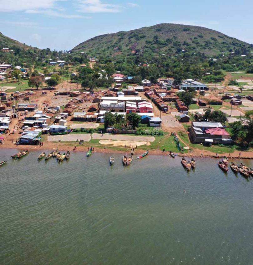
The Lake Victoria Basin is the lifeblood of East Africa, The HIGHWAY project supported regional cooperation
supporting approximately 25% of the region’s popu- among the National Meteorological and Hydrological
lation. Lake Victoria hosts Africa’s largest inland fish- Services (NMHSs) of Kenya, Rwanda, Uganda and the
ery; it produces about 1 million tonnes of fish annually, United Republic of Tanzania. The project strengthened
employs over 200 000 fisherfolk and generates over professional relationships and trust among key NMHS
US$ 500 million annually in exports. Over 30 million staff in the countries through a shared sense of common
people live near the lakeside, with 1 400 landing sites purpose. The enhanced collaboration has resulted in a
or beaches from which 50 000 boats operate. Before the regionally harmonized set of marine weather forecasts
HIGH impact Weather Lake System (HIGHWAY) project, covering the whole of Lake Victoria. The forecasts are
on average, 3 000–5 000 deaths occurred on the lake issued twice daily, at the same time, and are easy for
each year due to marine accidents caused by strong fishing communities to understand and use.
winds and waves. No regional, operational early warning
This document comprises stories of success from the
systems existed to protect the health and safety of those
HIGHWAY project and its partners. The stories highlight
navigating and exploiting the natural resources of the
activities that have led to improved livelihoods of those
Lake Victoria Basin.
in lakeside communities, and that have high potential
The HIGHWAY project was an initiative of the Weather for replication and scale-up. The stories demonstrate
and Climate Information Services for Africa (WISER) strengthened institutional frameworks, improved access
programme, funded by the United Kingdom Foreign, to data sources, strengthened integration between
Commonwealth & Development Office (FCDO). The pro- producers and users, and strengthened capacities of
ject developed regional early warning systems to alert NMHSs. This endeavour adds value to fieldwork by cap-
fisherfolk and other local stakeholders about high-impact turing and disseminating knowledge that promotes, tar-
weather on Lake Victoria. It has laid the foundation for a gets and optimizes public investments in early warning
more integrated and collaborative regional approach to systems for vulnerable communities.
the delivery of early warnings serving East Africa.
2
ACKNOWLEDGEMENTS
The HIGHWAY project was made possible with the financial contribution of FCDO through the WISER programme,
and the collaboration of various partners including the East African Community (EAC), Kenya Meteorological
Department (KMD), Lake Victoria Basin Commission, the UK Met Office, National Center for Atmospheric Research
(NCAR), Rwanda Meteorological Agency (Meteo Rwanda), Tanzania Meteorological Authority (TMA), Uganda National
Meteorological Authority (UNMA) and University Corporation for Atmospheric Research (UCAR).

CONTRIBUTORS
Lead author: Robert Powell
Other contributors (in alphabetical order):
David Agangu, Nam Lowle FM, Kenya
Benjamin Bahati and Paul Oloo, KMD, Kenya
Robert Bakaaki, Uganda Beach Management Unit Network, Uganda
Ladislaus Changa’a, TMA, United Republic of Tanzania
John Faragher, Met Office, United Kingdom of Great Britain and Northern Ireland
Jimmy Kagaruki, Metro FM, United Republic of Tanzania
Sylvester Kaywa, Busia County Beach Management Unit, Kenya
Julius Kiprop and Yusuf Nsubuga, UNMA, Uganda
James Kivuva, EAC
Henry Kizito, KAFOPHAN, Uganda
Mark Majodina and Luis Filipe Nunes, WMO
Rita Roberts and Jim Wilson, NCAR, United States of America
Mohamed Salim, Azam TV, United Republic of Tanzania
Joseph Sebaziga, Rwanda Meteorological Agency, Rwanda

                                                                                                                3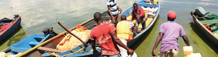
CONTENT

    FOREWORD. . . . . . . . . . . . . . . . . . . . . . . . . . . . . . . . . . . . . . . . . . . . . . . . . . . . . . . . . . . . . . . . . . 02

    ACKNOWLEDGEMENTS . . . . . . . . . . . . . . . . . . . . . . . . . . . . . . . . . . . . . . . . . . . . . . . . . . . . . . . 03

    STORIES OF SUCCESS:

    01 Meeting the forecasting needs of fishing communities. . . . . . . . . . . . . . . . . . . . . . . . . . . 05

    02	Broadcasting weather forecast bulletins through radio stations . . . . . . . . . . . . . . . . . . . 06

    03 Communicating weather information to fishing communities via social messaging.                                                         07

    04	Harmonizing weather forecasts across Lake Victoria Basin. . . . . . . . . . . . . . . . . . . . . . . . 08

    05	Trusting and using the co-produced weather forecasts. . . . . . . . . . . . . . . . . . . . . . . . . . . 09

    06	Improving meteorological observations and developing new forecasting tools . . . . . . 10

    07	Enhancing regional cooperation through voluntary and informal initiatives . . . . . . . . . 11

    08	Further developing cooperation through East Africa’s Vision 2025 regional early
        warning strategy. . . . . . . . . . . . . . . . . . . . . . . . . . . . . . . . . . . . . . . . . . . . . . . . . . . . . . . . . . 12

    09	Communicating weather forecast information universally, across Lake Victoria. . . . . . 13

    10 Monitoring the quality of meteorological data from East Africa. . . . . . . . . . . . . . . . . . . . 14

    11	Reviving and improving a pilot forecast system in Kenya. . . . . . . . . . . . . . . . . . . . . . . . . 15

    12	Developing Lake Victoria weather forecasts in Uganda. . . . . . . . . . . . . . . . . . . . . . . . . . . 16

    13 A
        dapting commercial shipping forecasts for fisherfolk in United Republic
       of Tanzania . . . . . . . . . . . . . . . . . . . . . . . . . . . . . . . . . . . . . . . . . . . . . . . . . . . . . . . . . . . . . . . 17

    14	Developing weather forecasts and engaging with users in Rwanda. . . . . . . . . . . . . . . . . 18

    15	Forecasting wave heights and waterspouts on Lake Victoria . . . . . . . . . . . . . . . . . . . . . . 19

    16	Improving the understanding of weather development through observation. . . . . . . . . 20

    17	Communicating forecasts and severe weather warnings. . . . . . . . . . . . . . . . . . . . . . . . . 21

4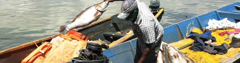
MEETING THE FORECASTING
NEEDS OF FISHING
COMMUNITIES

Photo: Samuel Gatei

Fishing communities on Lake Victoria need to receive accurate            Field research shows high levels of awareness and use of the
and timely weather forecasts prior to fisherfolk heading out             forecasts in fishing communities – particularly in Kenya and
onto the water. Such forecasts can help to reduce loss of life           Uganda, where they are widely broadcast by radio stations.
and economic losses due to boat damage.
The HIGHWAY project assisted NMHSs in the Lake Victoria                      Robert Bakaaki, a national fisherfolk leader
Basin to develop forecasts for fisherfolk based on user needs                in Uganda, who operates fishing boats and
identified. A co-design method was used to create accurate,                  fuel supply boats on Lake Victoria, said:
timely and understandable forecasts to ensure uptake from                    “The forecasts are always timely, accurate,
local communities around the lake.
                                                                             reliable and easily understood. They help me
                                                                             plan my daily activities... minimizing fuel costs
CO-DESIGNING FORECASTS                                                       and eliminating potential risks and dangers
Interviews and focus group discussions were held with local                  to both my crew and my boats.”
fishing communities. Government officials responsible for
fisheries and marine safety were also interviewed, and talks
held with radio stations popular in lake shore and island
communities.
These revealed fisherfolk need daily forecasts with accurate                 Sunday
                                                                             29 November
                                                                                             Wind
                                                                                           strength
                                                                                                        Wind
                                                                                                      detection
                                                                                                                    Wave
                                                                                                                    height
                                                                                                                                  Weather
                                                                                                                                                   Rainfall
                                                                                                                                                 distribution
                                                                                                                                                                 Visibility      Hazards

weather information such as wind speed and direction that                    Sunday
                                                                             Morning
highlight when severe weather is expected.The consultations
also made clear that fisherfolk need weather information in                                Moderate   Variable    Small waves    Thunder rain    Few places     Moderate
                                                                             Sunday
their local language before the start of each fishing trip in                Afternoon

order to plan their route and decide what precautions to adopt.                            Moderate     West      Small waves   Moderate rain    Few places      Good
                                                                             Night
Initial templates developed were refined in conjunction with                 before
                                                                             midnight
                                                                                                                                                                               Wide spread
                                                                                                                                                                              thunder storms
fisherfolk and government and media representatives at                                     Moderate   Variable    Small waves
                                                                                                                                 Wide spread
                                                                                                                                thunder storms   Many places

a series of co-design workshops.                                             Night
                                                                             after                                                                                             Wide spread
                                                                             midnight                                                                                         thunder storms
                                                                                                                                 Wide spread
The workshops developed simple impact-based definitions                                    Moderate   Variable    Small waves    thunder rain    Many places

of the terms used to describe marine weather that fishing
                                                                            A 24-hour forecast for the Buvuma and Northeast marine zone
communities could relate to easily. For example, “strong                    in Uganda with an orange “be prepared” warning. The weather
wind’’, defined in meteorological terms as 41–60 km per hour,               icons and colour shading enable fishermen to understand the
was described as: “The wind causes large trees to sway. It is               forecast information easily, even if they cannot read English.
strong enough to cause large waves and makes navigation
conditions difficult for small boats.”
                                                                                                       Meteorologists define the height of
The workshops also finalized the design of visual weather                                              “moderate waves” on Lake Victoria
icons used to illustrate the forecasts. A list of practical advice                                     as 1.0–1.5 m. That does not mean much to
messages for small boat users was drafted. These messages                                              many fisherfolk. But comparing the wave
are often published alongside severe weather warnings.                                                 to the height of a person communicates
                                                                                                       the information clearly.

PRODUCING FORECASTS AND HELPING TO SAVE
LIVES
The co-design process led to similar marine weather forecasts
appearing in areas of Kenya, Uganda and the United Republic of
Tanzania. Each country divides its part of the lake into different           Across Lake Victoria as a whole, the forecasts
marine forecasting zones. Their NMHSs divide their forecasts for             produced have helped to reduce drownings
each zone into 6 hour time periods. In all three countries, the marine       by about 30%, thus saving hundreds of lives
forecast gives information about wind speed and direction, wave              each year. They have also led to an estimated
height, rainfall, visibility and high-impact weather expected.               US$ 44 million of financial benefits from money
The first forecast of the day goes out in early morning before               earned or saved by taking action in response to
the day fisherfolk and transport canoes leave their landing                  weather forecast information.
sites. The second forecast is published in mid-afternoon
before the night fisherfolk depart.

STORIES OF SUCCESS — 01                                                                                                                                                                        5
BROADCASTING WEATHER
    FORECAST BULLETINS
    THROUGH RADIO STATIONS

    Photo: Samuel Gatei

    The radio stations, keen to attract strong audiences, ensure            David Agangu, a presenter on Nam Lolwe
    listeners get vital information about weather conditions on             FM in Kisumu, Kenya, said: “The information
    the lake when they need it most – before the boats leave their
                                                                            that is being sent to us by the Kenya
    landing sites in the early morning and late afternoon.
                                                                            Meteorological Department … is in simple
    Presenter Benjamin Benda Okoch on Bulala FM in Kenya airs               language. This makes it easy for us to
    the forecast bulletin for fishing communities. Photo: Samuel
                                                                            understand and for me as a presenter to do
    Gatei
                                                                            the translation in order to transmit it in my local
                                                                            language. The illustrations which accompany
                                                                            the text … help us to broaden our explanation
                                                                            to the listener.”
                                                                            Agangu also said large companies that target
                                                                            farmers and fisherfolk now insist their adverts
                                                                            on the station are aired a few seconds before
                                                                            or after each weather forecast. “This has added
                                                                            some revenue to our station,’’ he said.

    WORKING TOGETHER WITH RADIO STATIONS                                Translation of the forecasts into local languages was not
                                                                        required in the United Republic of Tanzania since TMA pub-
    Right from the start, the HIGHWAY project identified the            lishes its forecasts in Swahili, the language spoken fluently
    most popular local radio stations in fishing communities and        by nearly all Tanzanians.
    involved them in the co-design process of the forecast bulletins.
    Radio station participation ensured the forecast bulletins              Jimmy Kagaruki, a presenter on Jembe FM
    were easy for radio journalists to understand and interpret.            in Mwanza, United Republic of Tanzania,
    HIGHWAY also trained radio station personnel how to use
                                                                            said listeners often comment on the high
    the bulletins most effectively.
                                                                            accuracy of TMA forecast bulletins for fishing
    Such media training workshops were held in Kenya and                    communities. “Many of our listeners conduct
    Uganda for 20 radio stations that broadcast to Lake Victoria
                                                                            their daily activities on the lake and this kind
    fishing communities. At each workshop, weather forecasters
    and fisherfolk leaders joined the journalists to help create            of information is very crucial as it saves their
    concise bulletins in local languages that contained all the             lives,’’ Kagaruki said.
    essential weather information needed by listeners.
                                                                        Radio stations are happy to broadcast the forecast bulletins
    REACHING FISHING COMMUNITIES                                        twice a day or even more frequently, because they know accu-
                                                                        rate weather information is important for their listeners and
    More than 50 local and regional radio stations now broadcast        will attract strong audiences. At least two HIGHWAY partner
    to lakeside and island communities in Kenya, Uganda and             stations have managed to attract commercial sponsorship
    United Republic of Tanzania. As the HIGHWAY project was             for their marine weather bulletins.
    drawing to a close, half of them were carrying the twice-daily
    forecast bulletins for fisherfolk.
    Field research in Kenya and Uganda showed more people are
    receiving the marine forecast bulletins by local radio than any
    other means. It found strong awareness of the forecasts in
    nearly all fishing communities in those countries.                      NMHSs can disseminate their forecasts through
    Kenyan and Ugandan fishing communities know the fore-                   radio station broadcasts. This is done free of
    cast bulletins are available at fixed times on at least two             charge, to millions of people in lakeside and
    or three local radio stations that they can listen to clearly.          island communities, in local languages and
    They also know the weather information will be delivered in             in a timely manner.
    local languages such as Dholuo, Kinyala, Luganda, Lusoga
    and Suba.

6   STORIES OF SUCCESS — 02
COMMUNICATING WEATHER
INFORMATION TO FISHING
COMMUNITIES VIA SOCIAL
MESSAGING

Checking the latest forecast at a landing site in Uganda. Photo: Samuel Gatei

Ownership of smartphones within the fishing communities on                      video clips of the weather and ask questions. This lively
Lake Victoria is increasing rapidly. At each landing site, there                dialogue has proved highly motivating for forecasters.
are at least two or three people who own a smartphone and                       Most had never previously spoken directly with people who
often several dozen. Many fishing communities now have                          use their bulletins. It also helps enormously with forecast
their own WhatsApp groups, which provide a valuable way                         verification.
of disseminating weather information to friends, colleagues
and neighbours.                                                                    Julius Kiprop, a HIGHWAY project focal point
The HIGHWAY project harnessed the Internet to send marine                          said: “The use of WhatsApp has increased user
weather forecasts and severe weather warnings directly to                          confidence in the weather information. Users
the smartphones of interested individuals and fisherfolk in                        can tell us what they think and know they will
the Lake Victoria region by WhatsApp.
                                                                                   get an instant response. People even call us
                                                                                   to request bulletins they have missed. The
USING SOCIAL MESSAGING
                                                                                   feedback on WhatsApp has meanwhile given
Many development projects have used SMS text messages
                                                                                   UNMA forecasters a better understanding of
since the early 2000s to communicate important information
to mobile phone users. But WhatsApp allows more informa-                           the fishing community and how it uses the
tion to be sent in each message, and it is much cheaper to                         forecasts.”
operate. These factors make WhatsApp more attractive than
SMS and more financially sustainable.                                           NMHSs have also found WhatsApp useful for disseminat-
                                                                                ing many other types of information of interest to lakeside
In addition, PDF files attached to a WhatsApp message                           communities. These include national severe weather warn-
can communicate much more weather information than                              ings, seasonal forecasts, information about the movement
a 160-character SMS. They can also convey information using                     of locust swarms and even advice on how to keep safe from
images such as weather icons and maps. And there are no                         Covid-19.
transmission charges. Senders and receivers of WhatsApp
messages simply need an active Internet connection on their
phones to exchange information.
The HIGHWAY project therefore chose East Africa’s most                                                David Birimuye is a community
widely used social messaging app – WhatsApp – to send                                                 intermediary on Buvu Island in Uganda
marine weather forecasts for Lake Victoria to fishing leaders,                                        who receives the Lake Victoria forecasts
community intermediaries at landing sites, radio journalists,                                         by WhatsApp on his smartphone. David
                                                                                                      owns and operates a loudspeaker
government officials and other interested individuals.
                                                                                                      system at the landing site known as the
                                                                                                      “community radio”, and broadcasts each
COMMUNICATING INFORMATION                                                                             bulletin loud and clear to all 3 000 people
                                                                                                      in the village.
As well as receiving the information themselves, many recip-
ients instantly forward the forecasts to dozens of people in                                          David earns money by charging other
other WhatsApp groups to which they belong. This cascades                                             people to use his loudspeaker system to
the weather information rapidly to thousands more people.                                             make announcements, but he broadcasts
                                                                                                      the forecasts for free as a public service.
For example, whenever UNMA issues a severe weather warn-
ing for Lake Victoria, Willy Lugoloobi, the Chair of Kalangala
District Council, forwards the message immediately to
more than 500 people in the Ssese Islands through his own
WhatsApp groups.
Some people who receive forecasts by WhatsApp also pass
on the information by other means. Radio journalists broad-                         Using WhatsApp helps fishing communities to
cast weather forecast bulletins at fixed times on the radio.                        receive weather forecast information in a timely
Community intermediaries call meetings to share the latest                          manner. In return, forecast users also give
forecast with their neighbours. In some cases, they raise                           immediate and spontaneous feedback, which aids
a warning flag if severe weather is expected.                                       verification.
Forecast recipients often send short text and voice messages
back to the forecasting office. They also send in photos and

STORIES OF SUCCESS — 03                                                                                                                             7
HARMONIZING WEATHER
FORECASTS ACROSS LAKE
VICTORIA BASIN
Landing a catch of Nile perch from Lake Victoria. Photo: Samuel Gatei
Being Africa’s largest lake by area, Lake Victoria is divided
among three countries: Kenya, Uganda and United Republic Tuesday Wind Wind Wave Rainfall
Weather Visibility Hazards
of Tanzania. 29 December strength detection height distribution
Tuesday
The HIGHWAY project helped these three countries to pro- Morning
duce a regionally harmonized set of marine weather forecasts Light Variable Small waves Sunny intervals Good
covering the whole of Lake Victoria. These are issued at the Tuesday
Afternoon
same time, twice a day, and are easy for all fishing commu- SE
nities to understand and use. Light Southest Small waves Thunder rain Few places Good
Night
before
midnight
CO-DESIGNING REGIONAL FORECASTS Light Variable Small waves Partly cloudy
Night
Frequent consultation among NMHSs of the three countries after
midnight
led to a natural convergence in the format and content of the Light Variable Small waves Partly cloudy
forecasts developed and the timing of their dissemination.
Jumanne Nguvu ya Muelekeo Urefu wa Mtawanyko
Utabiri Uono Hali Hatari ya
29 Disemba upepo upepo mawimbi wa mvua
At a HIGHWAY regional meet- Asubuhi
Uganda Kenya
ing in 2019, the three NMHSs
agreed to divide Lake Victoria Upepo mdogo Kusini Mawimbi madogo Mvua na ngurumo
Maeneo
Wastani
I X machache
IX into 10 standard marine fore- Asubuhi
II VII casting zones. Most of these SE
VIII
are cube-shaped areas of Upepo
wastani
Kusini-
Mashariki
Mawimbi
wastani
Mvua na ngurumo Maeneo
machache
Wastani
III VI coastline, islands and open
water measuring roughly The day forecast for adjacent marine zones of Uganda (top) and
100 km by 60 km, although United Republic of Tanzania (bottom). The UNMA 24 hour forecast
IV V
includes the following night. The TMA 12 hour forecast features an
some are much smaller.
orange severe weather warning for the afternoon.
Kenya was the first of the three
United Republic
of Tanzania
countries to design a forecast
Agreed division of Lake Victoria into for fishing communities. KMD
10 marine forecasting zones. revived and enhanced a pilot special precautions if you go out on the lake and seriously
forecast for Kenyan fisherfolk consider postponing your voyage. Red indicates “extreme
on Lake Victoria that was published between 2016 and 2017, danger”, very severe weather. It warns boats to remain onshore
and increased its frequency of publication to twice daily. or head immediately for shelter.
Kenya’s experience subsequently informed the co-design of A daily teleconference involving forecasters at KMD, TMA
a similar forecast in Uganda. The United Republic of Tanzania and UNMA ensures these warnings are mutually agreed and
then benefited from the experience of both its neighbours well coordinated.
when designing its forecast for fisherfolk.
The forecasting offices of all three NMHSs then share their pub-
As a result, all three countries use the same standard terms lished forecasts for Lake Victoria through a WhatsApp group.
to describe marine weather conditions on Lake Victoria and
the same set of visual weather icons. The Lake Victoria forecasts are also shared across borders at
the user level. Nearly 100 fisherfolk in Kenya’s Busia County
on the Ugandan border receive UNMA marine forecasts for
PRODUCING AND COMMUNICATING FORECASTS the Ugandan sector of the lake. KMD forwards UNMA bulle-
Each country issues two marine forecasts per day: one in the tins to them through the same WhatsApp group that it uses
early morning for day fisherfolk and transport craft, and one to disseminate its own marine forecasts to Busia County.
in the afternoon for night fisherfolk. These bulletins forecast
wind speed and direction, wave height, sky conditions and
visibility for each zone of the lake.
All the forecasts carry severe weather warnings when appro-
Regional harmonization of the marine forecasts
priate. These are highlighted by a three-colour traffic light
for the Lake Victoria Basin has made it easier for
system that describes the conditions expected during each
6 hour period. fishing communities to understand and follow
them.
Green means “business as usual”, no severe weather expected.
Orange means “be prepared”, severe weather is likely. Take
8 STORIES OF SUCCESS — 04TRUSTING AND USING THE
CO-PRODUCED WEATHER
FORECASTS
A trader with her purchase of silver fish. If rain falls on the fish while drying on the ground, they will rot. Photo: Samuel Gatei
Lakeside and island communities around Lake Victoria widely TRUSTING THE FORECASTS
trust the marine forecasts for Lake Victoria created through
Focus group discussions at landing sites in all three coun-
the HIGHWAY project.
tries found most participants consider the marine forecasts
This is because the communities regard the forecasts are accurate on about 5 days out of 7 in a week. This gives
as being locally accurate for the waters around each a perceived accuracy rate of about 70%.
landing site.
Field research showed that if rough weather is forecast,
people venturing out onto the lake in small boats often take
ENSURING THE FORECASTS ARE LOCALLY special precautions. These include wearing life jackets from
ACCURATE the moment they leave the landing site, staying close to the
Three factors have helped to ensure the forecasts are locally shore and carrying extra fuel for outboard motors in case of
accurate. problems. In many cases, forecast users simply postpone
their trip to await calmer and safer conditions. These factors
First, the three countries surrounding the lake divide it into have helped to reduce the number of drownings.
10 marine forecasting zones. Detailed forecasts are issued
for each zone. The forecasts are appreciated by those who travel in
boats on the lake. They have also proved useful to peo-
Second, the 24 hour forecast for each zone is divided into ple engaged in many other kinds of activity. For example,
four 6 hour periods. This enables forecasters to predict fish traders who buy and dry silver fish (Rastrineobola
with a strong degree of confidence when weather condi- Argentea) are keen to know whether any rain is coming.
tions are likely to change during the course of the day. Rain causes the small fish that they spread out in the sun
If strong winds, high waves, heavy rain or widespread to dry to get wet and rot.
thunderstorms are expected, the forecasts say precisely
where and when such high-impact conditions are likely Many fisherfolk are also subsistence farmers. Field research
to occur. in Uganda found that some people in the Ssese Islands were
also using the forecasts to help plan their farm work as well
Third, Kenya, Uganda and United Republic of Tanzania NMHSs as their fishing trips.
all update their marine forecasts at 12 hour intervals. This
ensures fishing communities can always get the most up-to- Kalangala Infrastructure Services, the local electricity and
date weather information before boats leave the landing site water supply company on the Ssese Islands, regards the
in the early morning and late afternoon. forecasts as so important that it disseminates them to all its
70 employees by WhatsApp. The company is particularly on
the lookout for severe thunderstorms that may cause cuts in
the electricity supply.
Several hotels in the Ssese Islands meanwhile use the
Lake Victoria forecasts to help plan outdoor activities for
their guests.
Fishing communities trust and use the marine
forecasts for Lake Victoria because they are
perceived as being locally accurate. This strong
trust in the twice-daily forecasts has made people
confident about using the weather information
to plan fishing trips and other journeys in small
boats.
The high level of trust in the forecasts also means
users take severe weather warnings seriously
whenever they are issued.
Photo: Samuel Gatei
STORIES OF SUCCESS — 05 9IMPROVING METEOROLOGICAL
OBSERVATIONS AND DEVELOPING
NEW FORECASTING TOOLS
Satellite dishes at KMD headquarters, Nairobi. Photo: WMO
The HIGHWAY project helped to enhance meteorological TRAINING FORECASTERS
observations in the Lake Victoria Basin and to develop new
The HIGHWAY project’s partner in the United States of
tools for improving the accuracy of severe weather forecast-
America – UCAR – meanwhile provided weather radar train-
ing in the region.
ing for forecasters from several NMHSs.
Together, these initiatives have improved the accuracy of
Its training for TMA in 2019 was combined with the creation
marine forecasts for fisherfolk and other small boat users
of a data link with the TMA Central Forecasting Office in Dar
on Lake Victoria.
es Salaam. This enabled TMA forecasters to use real-time data
from the Mwanza radar for the first time.
ENHANCING OBSERVATIONS
UCAR subsequently trained forecasters of UNMA how to
Several manual and automatic weather stations for record-
use data from the new weather radar at Entebbe, which was
ing observations situated around Africa’s largest lake have
installed in 2020.
been rehabilitated and some new ones added.
The Uganda training was delivered online because of travel
In addition, HIGHWAY funded the resumption of regular
restrictions imposed by the Covid-19 pandemic, so forecast-
weather balloon launches to conduct upper air soundings at
ers from Kenya, Rwanda and the United Republic of Tanzania
Lodwar and Nairobi in Kenya. The project also made financial
were able to take part in it as well.
provision for regular balloon launches to resume at Dar es
Salaam in the United Republic of Tanzania and Entebbe in
Uganda. DEVELOPING NEW TOOLS
Several new forecasting and data visualization tools were
A separate initiative optimized the use of weather radars at
developed or made available for deployment in East Africa
Kigali, Entebbe and Mwanza. This enabled Rwanda, Uganda
with assistance from the HIGHWAY project. These were
and the United Republic of Tanzania to improve forecasting
mostly aimed at improving the nowcasting forecasting of
of thunderstorms and heavy rainfall over the Lake Victoria
thunderstorms by tracking their formation and development.
Basin.
However, at the end of the HIGHWAY project, few were ready
The radars also help to verify the accuracy of forecasts after for deployment.
they have been issued. Subsequent scans show exactly which
One initiative that had an immediate impact on forecasts for
areas were affected by rain and thunderstorms and which
the Lake Victoria region was the enhancement of the Tropical
were not.
Africa forecasting model of the Met Office, United Kingdom
HIGHWAY helped to recalibrate the weather radar at of Great Britain and Northern Ireland. Kenya, Uganda and
Kigali to improve the accuracy of data. It also financed United Republic of Tanzania NMHSs extensively use this
repairs, maintenance and the purchase of spare parts model.
for the weather radar at Mwanza, at the southern end of
The Met Office improved the grid definition of its Tropical
Lake Victoria.
Africa model to squares of 4.4 km from squares of 10 km
previously. This improved the model’s ability to pinpoint
convection and forecast the development of thunderstorms.
Paul Oloo, the HIGHWAY focal point at KMD, said this had
been a big help to Kenyan forecasters.
The improvement of meteorological observations
and the development of new forecasting tools
has contributed to greater forecast accuracy in
the Lake Victoria region.
Analysing images from the Mwanza weather radar,
United Republic of Tanzania. Photo: Mohamed Salim
10 STORIES OF SUCCESS — 06ENHANCING REGIONAL
COOPERATION THROUGH
VOLUNTARY AND INFORMAL
INITIATIVES
Fisherfolk on Lake Victoria. Photo: Samuel Gatei
Much of the practical collaboration among the East African Together, these initiatives led to a seamless set of similar
countries surrounding Lake Victoria achieved through the marine forecasts covering the whole of Lake Victoria. All three
HIGHWAY project was the result of informal voluntary coop- services use the same language and weather icons to describe
eration. This gave immediate results, while new statutory weather and wave conditions. They also forecast the weather
arrangements were negotiated more slowly at the intergov- for each zone of the lake in 6 hour periods and use the same
ernmental level. three-colour code to describe the weather conditions during
each period.
PROMOTING COLLABORATION AND
COOPERATION
The HIGHWAY project stimulated informal collaboration
Three-colour code for describing marine weather on Lake Victoria
through the establishment of personal relationships and trust
among key individuals in Kenya, Uganda and United Republic Green – Business as usual; no severe weather expected.
of Tanzania NMHSs. Orange – Be prepared; consider postponing your trip or take
The frequent regional meetings and trainings organized special precautions if you do undertake a voyage.
by HIGHWAY encouraged networking and the informal dis- Red – Extreme danger; do not go out on the lake in a small boat.
cussion of regional cooperation in practical terms. The project If you are on the water already, head for safety.
also fostered the establishment of institutional goodwill and
a shared sense of common purpose.
Daily consultations were established involving KMD, TMA
and UNMA to align the early warning service content of their Informal collaboration among the three NMHSs also took
marine forecasts for Lake Victoria. These discussions were place at the technical level. When KMD received a first con-
conducted through an existing daily conference call to coor- signment of new radiosondes, it invited TMA technicians to
dinate severe weather forecasting in East Africa as a whole. Nairobi to learn how to use the equipment. Radiosondes
are attached to balloons. They beam back measurements of
weather conditions in the upper atmosphere as the balloon
PRODUCING OUTCOMES
rises. Kenya was able to reactivate its use of radiosondes
Consultations between KMD, TMA and UNMA at a regional before the United Republic of Tanzania, and was happy to
meeting in 2019 led to the division of Lake Victoria into share its knowledge.
10 mutually agreed forecasting zones.
Links established through HIGHWAY also enabled meteorol-
Another important outcome was that Kenya, Uganda and ogists from Kenya, Rwanda, Uganda and United Republic of
United Republic of Tanzania NMHSs learned from each other Tanzania to collaborate in writing a study of the socioeconomic
how best to develop and communicate marine forecasts for impacts of extreme rainfall in East Africa, which was published
artisanal fisherfolk and other small boat users. The three online in 2020.1
NMHSs voluntarily coordinated the design, production and
publication of their twice-daily marine forecasts for Lake The above successes were achieved smoothly and without
Victoria. fuss because they did not require any external authoriza-
tion. Neither was there a requirement to overcome technical
UNMA learned from the KMD experience of co-designing challenges or set aside special budgets.
a marine forecast with local fisherfolk. It produced a weather
forecast bulletin similar in form and content to its Kenyan
counterpart. TMA subsequently drew on the Kenyan and
Ugandan templates when it re-versioned its daily forecast
for commercial shipping on Lake Victoria into a twice-daily
forecast for fisherfolk. NMHSs of the three countries surrounding Lake
Victoria have enhanced regional cooperation
In return, TMA shared its wave height forecasting model for
through several voluntary and informal
Lake Victoria with KMD and UNMA. This model is now used
to forecast wave heights for fisherfolk and other small boat initiatives.
users on Lake Victoria in all three countries.
1
hang’a, L., A. Kijazi, K. Mafuru, P. Nying’uro, M. Ssemujju, B. Deus, A. Kondowe, I. Yonah, M. Ngwali, S. Kisama, G. Aimable, J. Sebaziga and B. Mukamana,
C
2020: Understanding the evolution and socio-economic impacts of the extreme rainfall events in March-May 2017 to 2020 in East Africa. Atmospheric and
Climate Sciences, 10(4):553–572.
STORIES OF SUCCESS — 07 11FURTHER DEVELOPING
COOPERATION THROUGH EAST
AFRICA’S VISION 2025 REGIONAL
EARLY WARNING STRATEGY
Checking for weather warnings. Photo: Samuel Gatei
In addition to improving weather forecasting for the The HIGHWAY project helped EAC to draw up this £ 19.1 million
Lake Victoria Basin, the HIGHWAY project has also laid the (US$ 25 million) investment plan. Donor funding to finance
foundations for an ambitious early warning service covering it was still being sought as the project drew to a close in
the whole of East Africa. early 2021.
It has assisted EAC to shape Vision 2025 – a regional strategy The investment plan provides for the installation of new
for coordinating severe weather warnings throughout the six automatic weather stations, on land and on weather buoys
EAC member States. installed in East Africa’s Great Lakes.
It also foresees improved access to satellite information,
VISION 2025 greater use of numerical weather prediction in weather fore-
EAC ministers approved Vision 2025 in 2019, and all six EAC casting, better telecommunications links to share data and
NMHSs endorsed an implementation plan in 2020. specialist training for forecasters.
Within five years, Vision 2025 aims to create a statutory Vision 2025 builds upon the enhanced regional cooperation
framework for coordinating high-impact weather alerts among NMHSs in East Africa that was achieved through the
to vulnerable communities throughout Burundi, Kenya, HIGHWAY project.
Rwanda, South Sudan, Uganda and United Republic
It also follows a decade of regional cooperation in early
of Tanzania. It will cover an area much wider than the
warning services through the Severe Weather Forecasting
Lake Victoria Basin.
Demonstration Project. The latter established a daily con-
The Democratic Republic of the Congo, whose eastern regions ference call among EAC NMHSs and Ethiopia to help them
have strong economic and cultural links with East Africa, has coordinate their responses to forecasts of high-impact
applied to join EAC, so it may also become a participant in weather.
Vision 2025.
The investment plan that underpins Vision 2025 will fur-
ther improve the accuracy of marine forecasts for Lake
Victoria by providing valuable new sources of meteoro-
logical data.
It provides for the installation of weather buoys in the
Kenyan, Tanzanian and Ugandan sectors of the lake. These
will provide water temperature and wave height information
South Sudan for the first time, as well as recordings of wind speed and
direction over open water at surface level. There are also
plans to install more automatic weather stations on islands
in the lake.
Uganda In addition, Vision 2025 calls for the siting of a new weather
Kenya radar near Kisumu, a lakeside city in western Kenya. This
will provide better radar coverage of the north-east corner
Rwanda of Lake Victoria, It will complement radar coverage of the
Burundi lake already provided by weather radars at Kigali in Rwanda,
United Entebbe in Uganda and Mwanza in the United Republic
Republic of Tanzania.
of Tanzania
EAC member States
East Africa’s Vision 2025 regional early warning
strategy will further develop cooperation and
The strategy is backed by an ambitious plan to strengthen coordinate early warnings among NMHSs
meteorological observations throughout the region, improve in the region.
severe weather forecasting and the dissemination of weather
information.
12 STORIES OF SUCCESS — 08COMMUNICATING WEATHER FORECAST
INFORMATION UNIVERSALLY, ACROSS
LAKE VICTORIA
Preparing to depart on a fishing trip. Photo: Samuel Gatei
Forecasts and severe weather warnings need to be trans- Moder- Koth Between 5 and 20 mm of Nitiere kind 5mm kod
ate manied- rain falls in 24 hours. It is 20mm e seche 24 Okonval
lated rapidly and accurately into a local language that all rain iere unlikely to rain hard for a chwe motegno kinde
long time. Visibillity may malach. Neno bedo matek
users can understand clearly. It is difficult to communicate be reduced while it is
raining, but the rain does
kochwe, to ma oknya
chando ahinya nguech mag
weather information effectively to rural communities who do not interfere seriousy with
the navigation of small
yiedhi matindo.
not speak the language in which it is written. craft.
Extract
Moder- Apaka Waves of 1.0 to 1.5 Apaka borne 1-1.5 m.
metres in height. Borne okchopie gok from
In the United Republic of Tanzania, there is no need to trans- ate manied-
waves iere The waves are no higher jal marabora, kata wiingat Kenya’s
than the shoulder of a tall manyadundo.
late the forecasts as TMA produces all its information prod- man or the top of the English–
head of a short man.
ucts in Swahili. Luo quick
Moder- Yamo 21 to 40 kn per hour. 21-38 km e saa achiel. reference
ate manied- The branches of trees Bede yien yungni, Yamo
In Kenya and Uganda, all forecasts and severe weather warn- wind iere sway in the wind. The mivo yiedhi mag tanga guide
wind is strong enough to ringo mapiyo, apaka
ings are produced in English, which is a language that few make a fishing canoe
move fast under sail.
matindo kata maniediere
nyalobedo.
people in Lake Victoria fishing communities speak fluently. Small to moderate waves
may form.
The HIGHWAY project tackled this problem in two innova- Moder- Neno You can see large objects Inyalo neon gik madongo
tive ways. ate
visibilli-
maoko-
tegno
that are between 5 and
10 km away in daylight.
manitiere 5km kod 10km
godiochieng. Gik manitiere
Distant landmarks cannot mochwa lore ok nen. Neno
ty ahinya be seen at all. Nearby gik machiegni eyo maler
landmarks may be bedo matek.
VISUAL WEATHER ICONS AND COLOUR CODES difficult to see clearly.
UNDERSTOOD BY ALL
The project helped to create a new set of weather icons to The bilingual guides were used to help train more than
visually describe marine weather conditions for artisanal fish- 400 community intermediaries in Kenya and 120 in Uganda.
erfolk and other residents of lake shore and island communi- Each trainee was also provided with a copy of the guide.
ties. These icons show weather impacts such as tree bending
In Kenya, a bilingual guide was produced in English and Luo,
and shedding twigs and leaves in strong wind.
the language spoken by more than 90% of fisherfolk in the
Kenyan sector of Lake Victoria. Luo is also widely used by
local radio stations. A second bilingual guide was produced
later for Kinyala-speaking fisherfolk near the Ugandan border.
In Uganda, a bilingual guide was produced in English and
Luganda, the main language spoken in the south of the coun-
Wind speed icons showing conditions ranging from “calm” to “very strong
try. Most Ugandan fishing communities speak either Luganda
wind” (left to right).
or Lusoga, a closely related language, as their mother tongue.
Such images ensure the forecasts are easy to understand, Both languages are widely used by local radio stations.
even if the user does not know English or does not think of
wind speed in terms of knots or kilometres per hour. Henry Kizito, a non-governmental organization
A three-colour code to describe expected weather conditions coordinator who organized the training of
in each forecast provided another useful visual aid to fore- 120 community intermediaries in the Ssese
cast users. This code, assigned to each marine zone and each Islands, Uganda, said, “People on remote
6 hour forecast period, helps small boat users to identify the
Lujaabwa Island told me that the reference
location and timing of any high-impact weather quickly and
easily. Severe weather is highlighted by an orange or red guide, along with the local weather flag and
signal. Green indicates fair weather and business as usual. noticeboard, have helped them to interpret
the forecasts very accurately. They have
BILINGUAL REFERENCE GUIDES saved lives.”
The project also developed a series of bilingual quick refer-
ence guides to help forecast users understand key terms used
in weather forecast bulletins and translate them quickly and
accurately into their local language.
These guides were co-designed by weather forecasters and Bilingual reference guides, colour codes and
fisherfolk leaders. They are constantly referred to by radio visual weather icons assist the rapid and accurate
journalists racing to prepare the next weather bulletin. They translation of weather forecast information
are also used by community intermediaries who receive the universally and into local languages.
forecasts by WhatsApp and share them with other people at
their landing site.
STORIES OF SUCCESS — 09 13MONITORING THE QUALITY
OF METEOROLOGICAL DATA
FROM EAST AFRICA
An automatic weather station in Nairobi that provides meteorological observation data. Photo: WMO
The HIGHWAY project has supported the establishment of or updates that might be needed to OSCAR/Surface,
a regional centre to check the quality of weather observations the WMO global repository of observational metadata for
that East Africa shares with the rest of the world. surface-based stations.
The regional WMO Integrated Global Observing System TMA meanwhile monitors the quality of the underlying
(WIGOS) Centre for East Africa monitors all weather data weather observations from its offices in Dar es Salaam.
submitted electronically from the region to the WMO Global TMA checks the data to ensure expected standards are
Telecommunication System (GTS). GTS receives weather met in terms of accuracy, regularity of submission and
observations from WMO Members and shares them with configuration.
forecasters globally.
HIGHWAY funded computer equipment and staff training for ENSURING THE QUALITY OF DATA
the new East African Regional WIGOS Centre (RWC), which Problems with data quality are commonly caused by the
is run jointly by Kenya and the United Republic of Tanzania. malfunction or breakdown of weather observation equip-
It began operating in July 2020, and monitors observations ment and the disruption of telecommunications links. During
submitted to GTS by Burundi, Kenya, Rwanda, South Sudan, its first seven months of operation, this binational opera-
Uganda and United Republic of Tanzania. tion opened 32 investigations into data anomalies. Eight of
them were satisfactorily resolved. At the end of this period,
MONITORING DATA 24 other investigations were still under way.
The data monitoring operation ensures any errors, distortions The East African RWC is one of several RWCs that are being
or anomalies in weather observations submitted to GTS by established across Africa to detect and resolve problems with
the six EAC member States are detected and followed up with data flowing into GTS close to their source.
a view to quick rectification.
The East African data are used by other NMHSs around the
Individual countries remain responsible for feeding their world for climate modelling and the production of automated
observations directly into GTS. But these are now moni- global and regional forecasts.
tored closely by technical experts at the East African RWC.
East Africa benefits directly from sharing weather informa-
Whenever the experts detect suspicious characteristics in the
tion in this way because forecasting models are widely used
data, they create an incident report using a WIGOS incident
by NMHSs in the region to help produce their own forecasts.
management system. This is logged and submitted to the
NMHS that sent the suspect data. That organization must then
investigate the malfunction and resolve it. Mark Majodina, the WMO Regional
Representative for Eastern and Southern Africa
KMD monitors metadata from East Africa at its headquar-
ters in Nairobi. It looks at (meta)data that describe and
said: “The improvement in meteorological data
categorize the weather observations that flow electronically inputs from the subregion will have a direct
from the region into GTS. KMD proposes any corrections benefit on weather forecast quality…
This is a significant milestone and will inspire
the expansion of observations in other parts
of the African continent.”
A regional centre has been established to
monitor the quality of meteorological data from
East Africa that are shared with the rest of the
world. The creation of this East African Regional
Centre was one of several HIGHWAY initiatives
that fostered stronger formal cooperation among
NMHSs in the region.
Weather station instruments. Photo: Samuel Gatei
14 STORIES OF SUCCESS — 10REVIVING AND IMPROVING A PILOT
FORECAST SYSTEM IN KENYA
Boats on Rusinga Island, Kenya. Photo: Robert Powell
The HIGHWAY project has enabled Kenya to revive a pilot
forecast for fisherfolk on Lake Victoria, improve its content
and dramatically extend its dissemination. Weather information board
at a landing site in Kenya.
The KMD forecast for fisherfolk is now broadcast twice daily, Photo: David Agangu
and is aired in local languages by eight radio stations that are
popular with lake shore and island communities.
DEVELOPING AND RAISING AWARENESS OF THE
USING THE FORECASTS
FORECASTS
Field research in 2020 showed that nearly everyone involved
HIGHWAY helped KMD to work closely with fishing commu- in fishing activities in the Kenyan sector of Lake Victoria was
nity leaders and local radio stations to enhance the format aware of the KMD forecasts and received them regularly.These
and content of the forecasts and the severe weather warnings people included fish traders and processors, as well as fishing
they often contain. crews and the crews and passengers of small transport vessels.
The partners also collaborated to raise awareness of the fore- Focus group participants said the forecasts influenced the
casts in fishing communities. behaviour of between half and three quarters of all residents
County leaders of the Kenyan Beach Management Unit in Kenyan fishing communities.
Network selected two volunteers with smartphones at each
landing site to become community intermediaries. Sylvester Kaywa, Chair of Beach Management
Joint teams of KMD staff, fishing leaders and fisheries depart- Units in Busia County, said: “Fishermen are
ment officials then trained the intermediaries how to receive able to receive the forecast in time before
the forecasts by WhatsApp, interpret them correctly and com- leaving the landing site and this has assisted
municate relevant information from them to local people. them to plan ahead… They are able to receive
Over 400 community intermediaries were trained to receive the forecast message in their local language
the forecasts on their smartphones and to disseminate them and understand and interpret it well.”
to local people at about 200 landing sites.
EXTENDING FORECAST REACH
Paul Oloo, KMD focal point for the HIGHWAY project, had
previously worked with fishing leaders in 2016 to co-design
a daily forecast for small craft users on Lake Victoria.
Broadcast of that pilot forecast lapsed after less than a year,
but fisherfolk liked the product, and Oloo played a key role
in reviving and improving it.
When he detected some unused HIGHWAY funds that had
been allocated to Kenya, Oloo had no hesitation in using the
money to train 300 more community intermediaries than the
project had originally planned.
A community intermediary announces the latest forecast by loudspeaker
at a landing site in Kenya. Photo: David Agangu That initiative extended the direct communication of
KMD forecasts for fisherfolk to more than 100 additional
landing sites.
Ten pilot landing sites were provided with weather informa-
tion noticeboards and weather flags that are managed by
the local intermediaries. This equipment has helped to com-
municate weather information to local people more easily.
Kenya has revived and improved its pilot forecast
Whenever the latest KMD forecast contains a warming of for fisherfolk on Lake Victoria. Weather forecasts
high-impact weather, the intermediary raises an orange or
now reach all landing sites and are widely used
red warning flag to replace the green flag that normally flies
in fairweather conditions.
for decision-making.
STORIES OF SUCCESS — 11 15DEVELOPING LAKE VICTORIA
WEATHER FORECASTS IN UGANDA
Small boats are widely used for transport as well as fishing. They are often heavily laden and vulnerable to changes in the weather. Photo: WMO
UNMA follows closely the weather over Lake Victoria because USING AND IMPROVING FORECASTS
it generates rainfall and thunderstorms throughout southern
The UNMA marine forecasts are widely used by lakeside
Uganda.
and island communities because they are easy to access.
UNMA also studies the weather over Lake Victoria closely At least 12 local radio stations popular in fishing communi-
because it influences aeroplanes taking off and landing at ties broadcast the forecasts in local languages, particularly
Entebbe international airport. The main runway ends at the Luganda and Lusoga.
lake shore.
UNMA disseminates the forecasts to radio journalists, fishing
UNMA forecasters are physically close to the lake, as they community leaders and community intermediaries at landing
work from an office in the airport control tower. Lake Victoria sites via WhatsApp.
is a constant presence in their lives. They see the boats dotting
This messaging app has proved more popular than email.
its surface every day as they go to and from work.
It prompts many forecast users to give instant feedback and
However, Uganda is a landlocked country with little experi- report weather-related events they have observed. Often, fish-
ence of marine weather forecasting. The HIGHWAY project erfolk send in photos and video clips to show local weather
helped it to produce a popular and influential forecast for conditions. They also report weather-related boat accidents.
fisherfolk and other small boat users on Lake Victoria.
Julius Kiprop, the UNMA focal point for the HIGHWAY pro-
ject, expects the accuracy of forecasts to improve further.
IDENTIFYING FORECAST NEEDS Forecasters are now using the new weather radar at Entebbe
UNMA identified the weather information needs of Ugandan to predict the weather. Soon, they will also receive observa-
fishing communities through a forecast co-design process tions from six weather buoys that the Ugandan Government
facilitated by HIGHWAY. Learning from Kenya, which had pre- is purchasing for deployment on Lake Victoria.
viously established a forecast for fisherfolk on Lake Victoria,
was also helpful.
Ugandan forecasters found they already had the data, the
analytical tools and the skills necessary to forecast wind,
wave height, rainfall and visibility on Lake Victoria.
Consultations with fishing community leaders during the Police Sergeant Stephen Sanyu on the remote island of Migingo
co-design process made UNMA forecasters aware of key frequently provides useful feedback to UNMA forecasters on weather
conditions in his sector of Lake Victoria.
weather thresholds beyond which navigation conditions
become difficult for small boats.
For example, wind speeds of more than 40 km per hour tend Kiprop said: “We are confident that the weather
to generate waves over 1.5 m in height. These can cause radar and the new weather buoys will enable
fishing boats and small transport craft to capsize or sink.
UNMA to produce even better forecasts for
Such conditions now trigger the issue of severe weather
warnings. fishermen and the island communities which
rely on water transport.”
Friday Wind Wind Wave Rainfall
“The direct contact of forecasters with fishermen
Weather Visibility Hazards
during the co-design process and through
08 January strength detection height distribution
Night
before
midnight
E subsequent feedback from forecast users,
Moderate East Small waves Partly cloudy has proved really motivational,” he added.
Night
after Winds
midnight and waves
SW
Strong Southwest Moderate waves Thunder rain Many places
Saturday
morning Landlocked Uganda produced a marine forecast
Moderate South Small waves Thunder rain Many places Moderate
for Lake Victoria that has proved popular and
Saturday influential. Fisherfolk consulted a year after the
forecast was launched said the bulletins were
afternoon
Light South Small waves Sunny intervals Good
generally accurate on 5 out of 7 days. The success
A warning of strong winds and high waves between midnight of this forecast has sparked demands for Uganda
and dawn in the UNMA south-western marine forecast zone. to produce similar bulletins for fisherfolk on
Lakes Kyoga and Albert.
16 STORIES OF SUCCESS — 12ADAPTING COMMERCIAL SHIPPING
FORECASTS FOR FISHERFOLK IN UNITED
REPUBLIC OF TANZANIA
New Igombe landing site near Mwanza, United Republic of Tanzania, where summaries of the TMA weather forecasts for fisherfolk arrive by SMS.
Photo: Samuel Gatei
Before the HIGHWAY project, TMA was already producing TMA uses the same simple language to describe weather
marine forecasts for Lake Victoria. It had even developed conditions, the same weather icons and the same colour code
a model for forecasting wave heights on the lake. to warn of severe weather as its East African neighbours. It
also adopted their practice of splitting each day into four
However, the TMA marine forecast for Lake Victoria
forecast periods of 6 hours each.
was aimed exclusively at commercial shipping. It used
meteorological terms that few artisanal fisherfolk could The launch of the TMA twice-daily forecast for fisherfolk on
understand. Lake Victoria was preceded by three stakeholder engage-
ment workshops held in important fishing districts along
HIGHWAY helped TMA to engage with local fisherfolk to
the lake shore. These helped identify about 100 people who
ascertain their weather information needs. It then helped
now receive the forecast by WhatsApp and a further 350 who
TMA to develop simpler ways of expressing marine weather
receive forecast summaries by SMS.
information to make it easier for people in fishing commu-
nities to understand. Initial feedback from users has been positive. Field research
shows they find the forecast information timely, accurate and
DEVELOPING THE FORECASTS useful. There is strong potential for it to reach fisherfolk at all
642 landing sites in the Tanzanian sector of Lake Victoria via
On the technical side, HIGHWAY enabled TMA to optimize
the many local and regional radio stations that broadcast to
the use of its weather radar in Mwanza at the southern end
lake shore and island communities.
of Lake Victoria for forecasting severe weather over the lake.
The radar was repaired and serviced, and a data link to TMA
headquarters in Dar es Salaam installed.
This enables TMA forecasters to obtain radar pictures of
weather over the lake in real time. HIGHWAY also trained
TMA forecasters how to interpret the radar data – particularly
for forecasting heavy rainfall and thunderstorms.
The new TMA forecast for fisherfolk divides the Tanzanian
sector of Lake Victoria into the same four marine forecast-
ing zones used in its forecast for commercial shipping. The
forecast for fisherfolk also contains the same types of marine
weather information: wind speed and direction, wave height,
sky conditions and visibility.
The format, language and visual features of the new bulletin
were inspired by the forecasts for artisanal fisherfolk that
HIGHWAY had already helped to develop in Kenya and
Uganda.
Jumanne Nguvu ya Muelekeo Urefu wa Mtawanyko
29 Disemba upepo wa upepo mawimbi
Utabiri
wa mvua
Uono Hali Hatari ya Amini Modesty, Beach Management Unit Chairman.
Asubuhi
Picture: Samuel Gatei
Maeneo
Upepo mdogo Kusini Mawimbi madogo Mvua na ngurumo Wastani
machache
Mchana
SE
Upepo Kusini- Mawimbi Mvua na ngurumo Maeneo
Wastani
wastani Mashariki wastani machache
Athari zinazoweza kutokea Ugumu wa shughuli za uvuvi na usafiri The United Republic of Tanzania adapted its
forecasts for commercial shipping on Lake
The day forecast for a marine zone in United Republic of Tanzania.
The 12 hour forecast features an orange severe weather warning Victoria into a product better suited to the needs
for the afternoon. of artisanal fisherfolk on the lake.
STORIES OF SUCCESS — 13 17You can also read