Strategic Environtment and Implementation of Satellite Technology Acquisition Programs in ASEAN
←
→
Page content transcription
If your browser does not render page correctly, please read the page content below

Strategic Environtment and Implementation of Satellite
                    Technology Acquisition Programs in ASEAN

                                            Robertus Heru Triharjanto
                                            Pusat Teknologi Satelit, LAPAN
                                           E-mail: robertus.heru@lapan.go.id

ABSTRAK – Seiring dengan pertumbuhan ekonomi di negara-negara ASEAN, keinginan negara-negara tersebut untuk
menciptakan pekerjaan dengan nilai tambah tinggi atau yang padat teknologi semakin besar. Hal tersebut, dipadu
dengan motivasi klasik untuk menciptakan kebanggaan bangsa dan strategi hankam, membuat negara-negara tersebut
memulai pengembangan program keantariksaan. Karena merupakan pengguna satelit, beberapa negara ASEAN
memulai program antariksanya dengan penguasaan teknologi satelit. Kajian literatur menunjukkan bahwa tujuan dari
program tersebut adalah untuk dapat memproduksi satelit di dalam negeri. Karena latar belakang tersebut, makalah ini
membahas tentang program penguasaan teknologi satelit di negara-negara ASEAN, dengan fokus pada lingkungan
strategis dan implementasinya. Tujuan dari kajian adalah untuk membuat peta posisi program dari masing-masing
negara. Metoda kajian adalah deskriptif analitis, di mana dibuat rangkuman dan perbandingan dari skala dan cakupan
program, regulasi teknologi, dan pengembangan organisasi pelaksana di masing-masing negara. Hasil kajian
menunjukkan bahwa semua negara ASEAN memulai penguasaan teknologi satelitnya dengan mengembangkan satelit
penginderaan jauh. Dari negara-negera tersebut, skala program teknologi satelit milik Singapura dan Malaysia adalah
yang tertinggi untuk saat ini, dan dimasa depan, program teknologi satelit Vietnam akan dapat menyamai skala program
milik Indonesia dan Thailand. Karena terbatasnya investasi, program teknologi satelit Indonesia diperkirakan tidak akan
berkembang lebih dari skala satelit mikro, kendati penguasaan teknologi dan badan antariksa telah dimiliki.

Kata Kunci: teknologi satelit, ASEAN, program antariksa

ABSTRACT – With the growth of economy in ASEAN countries, their desire to create high value-added jobs or high
technology industries are increasing. Such drive, in addition to the clasic motivation of creating national pride and
strategy for defense and security, made many of them started to have national space program. Since they are satellite
users, they started the program with acquiring satellite production technology. Due to such background, the paper
discusses about satellite technology acquisition programs in ASEAN countries, with focus on the program’s strategic
environment and implementation. The objective of research is to establish positioning map of satellite technology
aqusition program in ASEAN. The method used is decriptive analytics, in which data on the program scale and
coverage, technology regulations, and institutional buildings in each countries were sumarized and compared. The
study shows that all of the ASEAN countries started their satellite technology acquisition by developing remote sensing
satellites. It is found that Singapore and Malaysia are the highest in current satellite technology program scale, and in
the future, Vietnam’s program scale will catch up with Indonesian and Thailand’s. For Indonesia, even though it has
technology mastering and space agency, but lack of investment made it unable to move beyond micro-satellite program

Keywords: satellite technology, ASEAN, space program

1.     INTRODUCTION

1.1.   Background

       Economic growth in Asia in the past 20 years has surpased the world average (IMF, 2017). Data
shows that the countries’ GDP per-capita, represented by Japan, Korea, China, India, Thailand, Malaysia,
Philipines, and Indonesia, have increased at the minimum twice from 1990 to 2010 (Restrepo-Echavarria,
2017). Technology, i.e. mechanization and automation, and the improvement in the quality of human
resources are, among others, the factors that increase productivities, and therefore, brought the economic
growth (Woetzel, 2015). Such technology-based economy made Asian countries acquiring more
technologies by investing in infrastructures and human resources, to ensure their sustainable economic
growth. Among others, this was reflected by the growth in scientific publications made by academic
communities in Asian countries, which indicates the strengthening of academic institutions and therefore
knowledge-based economy (Moed and Haleva, 2014).

                                                          29
                                                           29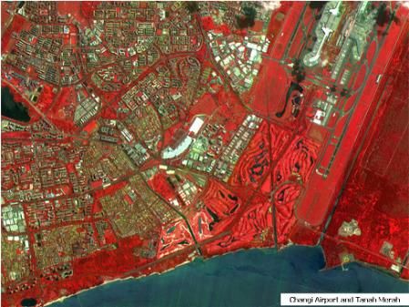
Seminar Nasional Kebijakan Penerbangan dan Antariksa III (SINAS KPA-III) 2018

      ASEAN (Association of South East Asian Nation) is a muti-national organization that currently
consist of 10 countries in South East Asia, i.e. Thailand, Malaysia, Philipines, Singapore, Myanmar,
Cambodia, Vietnam, Laos, Indonesia, and Brunei. The membership has grown from its initial 5 members
when founded in 1967. The purpose of the organization is to promote cooperation in economy, politics,
education, security, and socio-cutural. As mentioned by previous paragraph, some of ASEAN countries are
among the highest in Asian economic growth.

      As for the use of space technology, most in ASEAN countries use and own telecomunication satellites.
Such usage was started by Indonesia in 1976, due to its nature as largest archipelago. Currently, all major
ASEAN countries own telecomunication satellites. The satellites, however, are usually owned by private
companies, as telecomunication industries in the region is among the highest in market expansion (Åström,
2015).

       The United Nation started to promote the use of space-based remote sensing technology in late 80s.
Since then, many developing countries, including in ASEAN, start to adopt remote sensing technology as
part of their the national development strategy. Among others, Indonesia, Malaysia, Vietnam and Thailand
has addopted the technology in their agriculture, environtmental monitoring, and fisheries. Unlike in
telecomunication satellite, activities in space-based remote sensing is mostly done by government institution
or considered public services.

1.2.   Research question

      It is expected that the study will provide comprehensive map on ASEAN countries’ space program.
The data can be used to predict the future of space activities in the region. One of them is whether G-to-G
collaborations in space technology are possible between ASEAN countries, knowing that they have
economic and political ties.

1.3.   Objectives

      The objective of the research is to establish positioning map of satellite technology aquisition
programs in ASEAN countries. The study focus on the phenomena happen in the last 15-10 years, where
many of the countries began developing domestic capacity in remote sensing satellite technology.

1.4.   Methodology

      The method used is in this research is descriptive analytics. Similar method has been used in space
technology comparison studies as done be Ansdell (2011) and CRDS (2015). In this research, data on the
program scale and coverage, technology regulations, and institutional buildings in each countries were
sumarized and compared.

2.     DATA MINING RESULTS

       Even though the market value on the use of geostationary telecommunication satellites is much higher
than low Earth remote sensing satellites, the technological difficulty for geostationary satellites is much
higher. Therefore, in the effort of technology acquisitions none of ASEAN started their program with
telecommunication satellite. Many of them follow the satellite development trend at universities in
developing countries, where, to optimize the cost, use auxiliary payload launch opportunity. Such choice
limits the satellite that can be built to micro-satellite class (weight less than 150 kg).

        Thailand initiated its national remote sensing satellite development program by building TM-sat, that
was launch in 1998. The micro-satellite was built with the assistance of University of Surrey, and has
mission of experimental imager and capacity building (Sweeting and Pookyaudom, 1997). The country
established agency named GISTDA (Geo-Informatics and Space Technology Development Agency), that in-
charge in implementation of remote-sensing technology. The agency then bought a 750 kg remote sensing
satellite from Astrium (France), and gave name of THEOS-1 (Thailand Earth Observation System). The
satellite has 2 m panchromatic and 15 m multi-spectral imagers, with swath of 90 km, and was launched in
 30                                                              30
Seminar Nasional Kebijakan Penerbangan dan Antariksa III (SINAS KPA-III) 2018

2008 (Vongvivatanakij, 2008). At the time it was the most powerful remote sensing satellite owned by an
ASEAN country. The performance of TMSat and THEOS-1 can be seen in Figure 2-1.

      After the decommissioning of Theos-1 in 2014, GISTDA plan to establish the 2nd Thailand’s remote
sensing satellite, i.e. THEOS-2. The plan, however, were delayed for few years, so that until now the
subsequence satellite has not been launched (GISTDA, 2017).

   Figure 2-1. TM-sat and its image result (San Francisco bay), and Theoss-1 image result (Vongvivatanakij, 2008)

        Malaysia started its remote satellite technology development program by building its 1st micro-
satellite, TiungSat, with the assistance of University of Surrey. The satellite carried an experimental imager
payload, and was launched in 2000. The owner of the satellite is ATSB (Astronautic Technology Sdn Bhd).
The state-owned company was established on 1997 by the Malaysian Ministry of Science, Technology and
Innovation (MOSTI), and in-charge of developing satellite technology. At the time, Malaysia also has a
remote sensing agency named MACRES (Malaysia Center for Remote Sensing).

       Second remote sensing satellite developed by Malaysia is RazakSat-1. For its development, ATSB
built satellite integration and test facilities in Malaysia (see Figure 2-2). The payload of the 180 kg satellite
was developed with the assistance of Korean company SatReci (Kim et. al, 2003). The satellite imagers have
resolution of 2.5 m (panchromatic) and 5 m (multispectral), with swath of 20 km, and was launched to near
equatorial (low inclination) orbit as dedicated launch by SpaceX in 2009.

             Figure 2-2. Malaysian 1-ton class satellite integration facility and Razaksat-1 (ATSB, 2014)
      RazakSat-1 is declared inoperative 1 year after its launch. ATSB then prepares the development of
RazakSat-2. The satellite will have panchromatic imager with 1 m resolution and multi-spectral imager of 4
m, and will be launched in 2019 (TDA, 2016).

        Singapore started its remote sensing satellite technology development by acquiring UoSat-12 micro-
satellite from University of Surrey. The owner of the satellite is NTU (Nanyang Technology University).
The satellite carried an experimental imager payload, and was launched by DNPER in 1999. After that, NTU
                                                          31                                                              31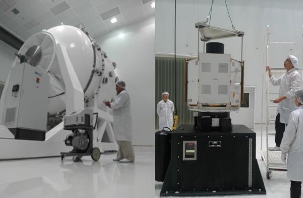
Seminar Nasional Kebijakan Penerbangan dan Antariksa III (SINAS KPA-III) 2018

developed its 2nd micro-satellite, XSat. The satellite has multispectral imager with 10 m resolution and 50 km
swath, and was launched by PSLV (India) in 2011. The image result of XSat can be seen in Figure 2- 3.

      After acquiring micro-satellite technology, Singapore went into commercial approach by developing
Teleos-1 satellite. The 400 kg satellite is owned by private company, STE (Singapore Technology
Engineering), has panchromatic imager with resolution of 1 m, and launched into near equatorial orbit using
PSLV in 2016 (ANTRIX, 2016). Currently, STE is developing its 2nd satellite, Teleos-2, which will carry
SAR payload (Hui, 2017).

            Figure 2-3. Image result of XSat (NTU, 2016) and development of Teleoss-1 (Via Satellite, 2016)

      Vietnam 1st remote sensing micro-satellite is VNREDSat-1. The satellite is made by France company,
Astrium, and has 2,5 m resolution panchromatic imager and 10 m resolution multi-spectral imager (see
Figure 2-4). The 130 kg satellite was launched with launched as auxiliary payload of European launcher
VEGA in 2013 (Phuong, 2016). The reference also mentioned that the next remote sensing satellite to be
acquired by Vietnam is LotusSat-1 and LotusSat-2. Both satellites will carry X-band SAR with image
resolution of 1 m. The 500kg satellites are built by NEC (Japan), and the 1st satellite is expected to be
launched in 2019.

        To handle the satellite development program, Vietnam Academy of Science and Technology (VAST)
established Vietnam National Satellite Center (VNSC) in 2011. Especially for technology acquisition, VNSC
also developed micro-satellite named MicroDragon. The satellite was built with the assistance of Tohoku
University and Hokkaido University, to give VNSC personnel hands-on experience in satellite development
(Hiramatsu et al., 2016). The satellite was launched by Epsilon rocket in 2018. The goal of VNSC is to be
able to build LotusSat-2 in Vietnam, therefore, they prepare satellite integration and test facilities as
illustrated in Figure 2- 4, to be completed in 2020 (Phuong, 2016).

       Figure 2-4. VNREDSat-1 (top), JV-Lotus-1, and plan for Vietnam satellite center facilities (Phuong, 2016)

      Philippines started its remote sensing satellite development program by developing PHL-sat
(DIWATA-1). The 50 kg satellite is built with the assistance of Tohoku University and Hokkaido University,
and launched via International Space Station (ISS) in 2016. The development and operation of DIWATA-1
uses the human resources from University of Philippines. To sustainably handle the satellite development,
Department of Science and Technology (DOST) assign on of its subsidiary, Advanced Science and

 32                                                              32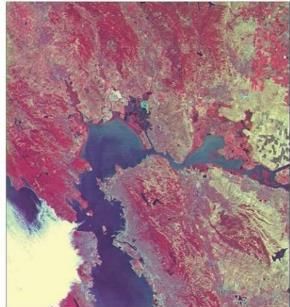
Seminar Nasional Kebijakan Penerbangan dan Antariksa III (SINAS KPA-III) 2018

Technology Institute (ASTI). The agency is now developing Philippines 2nd satellite, DIWATA-2
(Marcianno, 2016). DOST also currently crafting of a national space development and utilization policy.

      Among ASEAN nation, Indonesia is the first one to have space agency, named LAPAN, in 1963.
LAPAN established remote sensing application division in late 80s, and currently become the national
remote sensing data center. Using data from international medium and high resolution satellites, the division
serves Indonesian ministry of agriculture, for predicting harvest, ministry of forestry, for logging monitoring
and forest fire detection, and mapping agency (Roswintiarti, 2010).

        LAPAN started its remote sensing satellite development program in 2003, with the development of
LAPAN-A1/TUBSAT. The satellite was developed at TU Berlin, Germany, with the mission of Earth
surveillance and capacity building. The satellite was launched as auxiliary payload by PSLV in 2007. After
its 1st year of operation, LAPAN started the development of its 2nd and 3rd microsatellite, named LAPAN-
A2/ORARI and LAPAN-A3/IPB, in the country. For that, LAPAN established Satellite Technology Center,
which has infrastructures to develop and operate micro-satellites (Triharjanto, 2015). LAPAN-A2/ORARI,
which carry RGB camera with resolution of 5 m, and AIS (ship tracking system), was launched to near
equatorial orbit as auxiliary payload of PSLV in 2015. LAPAN-A3/IPB, which carry 20 m resolution multi-
spectral imager and AIS, was launched to polar orbit also with PSLV in 2016. LAPAN is currently
developing and planning its 4th and 5th microsatellites, i.e. LAPAN-A4, which will carry multi-spectral
imager and IR camera, and LAPAN-A5/ChibaSat, which will carry synthetic aperture radar and AIS
(Triharjanto and Hakim, 2017).

   Figure 2-5. LAPAN-A1 and LAPAN-A3 during launch vehicle assembly, and almost national coverage results of
                                   LAPAN-A3 images (Hakim, 2107)

    Based on references mentioned above, the ASEAN countries satellite development programs can be
summarized in table 2-1 to 2-3.

                                                       33                                                              33
Seminar Nasional Kebijakan Penerbangan dan Antariksa III (SINAS KPA-III) 2018

                           Table 2-1.: General Summary of ASEAN Countries Satellite Program

         Country        Program              Satellite built               Executing      Space Agency          Technology
                         started        In the          In partner          agency         /Stakeholder          partners
                                       country           country
       Indonesia        2003         LAPAN-A2,        LAPAN-A1            LAPAN          LAPAN              TU Berlin; Chiba
                                     LAPAN-A3                                            /integrated with   Univ.
                                                                                         remote sensing
                                                                                         agency
       Malaysia         1995         Razaksat-1       Tiungsat            ATSB           Angkasa            Univ. Surrey;
                                                                                         /MACRES            SatRec Initiative
                                                                                         (remote sensing
                                                                                         agency)
       Philippines      2014         -                Diwata-1            ASTI/Univ.     None               Tohoku/Hokkaido
                                                                          Philippines    /DOST (policy)     Univ.
       Vietnam          2010         -                VNREDSat-           VNSC           None               Astrium;
                                                      1, Micro-                          /VAST (policy)     Tohoku/Hokkaido
                                                      dragon                                                Univ.; NEC
       Singapore        1995         XSat,            UoSat-12            NTU, STE       None, only         Univ. Surrey;
                                     VELOX-CI,                                           space industry     Orbital-ATK
                                     Teleos-1                                            forum (SSTA)
       Thailand         1995         -                TM-sat,             MUT,           None/              Univ. Surrey,
                                                      Theoss-1            GISTDA         (remote sensing    Astrium
                                                                                         agency)
   Note: bold-red = non-micro, dedicated launch

                                   Table 2-2.: Satellite Mission Launched by ASEAN Countries

             Country            Satellite                    missions                               Payloads
                                (launch)
          Indonesia         LAPAN-A1              Experimental Earth                 Video camera
                            (2007)                observation
                            LAPAN-A2              Earth observation; maritime        RGB camera; AIS; APRS; voice
                            (2015)                surveillance; amateur              repeater
                                                  communication
                            LAPAN-A3              Land cover; maritime               Medium res. multi-spectral imager; AIS
                            (2016)                surveillance
          Malaysia          TiungSat              Land cover; amateur                Medium res. multi-spectral imager;
                            (1997)                communication                      store-forward
                            Razaksat-1            Land cover                         High res. multi-spectral imager
                            (2009)
          Philippines       Diwata-1              Land cover; weather                Hyper-spectral imager; IR camera
                            (2016)
          Vietnam           VNRedSat-1            Land cover                         High res. multi-spectral imager
                            (2013)
                            Micro-dragon          Land cover; weather                Hyper-spectral imager; IR camera
                            (2018)
          Singapore         Uosat-12              Experimental                       Medium res. multi-spectral imager;
                            (1997)                                                   store-forward
                            XSat (2011)           Land cover                         Medium res. multi-spectral imager
                            VELOX-C1              Climate monitoring                 GPS occultation
                            (2015)
                            Teleos-1(2015)        Mapping                            High resolution imager,
          Thailand          TM-sat                Land cover                         Medium res. multi-spectral imager;
                            (1997)                                                   store-forward
                            Theoss-1              Land cover, mapping                High resolution multi-spectral imager
                            (2008)

 34                                                                  34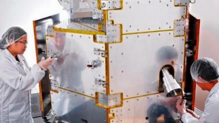
Seminar Nasional Kebijakan Penerbangan dan Antariksa III (SINAS KPA-III) 2018

                           Table 2-3.: Future Satellite Mission of ASEAN Countries

         Country           Satellite                  missions                                Payloads
                      (predicted launch)
       Indonesia     LAPAN-A4 (2020)       Land cover; maritime                 Medium res. multi-spectral
                                           surveillance; science                imager; AIS; magnetometer
                     LAPAN-                Land cover; Land deformation;        Synthetic Aperture Radar; AIS
                     A5/ChibaSat (2022)    maritime surveillance; ice
                                           monitoring
       Malaysia      Razaksat-2            Land cover; amateur                  Medium res. multi-spectral
                     (2019)                communication                        imager; store-forward
       Philippines   Diwata-2 (2018)       Land cover; disaster mitigation      Hyper-spectral imager; IR
                                                                                camera
       Vietnam       JV-Lotus1(2019)       Land cover; disaster mitigation      Synthetic Aperture Radar
                     JV-Lotus2 (2022)      Land cover; disaster mitigation      Synthetic Aperture Radar
       Singapore     Teleos-2 (2021)       Land cover; disaster mitigation      Synthetic Aperture Radar
       Thailand      Theoss-2 (2019)       Land cover, mapping                  High resolution multi-spectral
                                                                                imager

3.     ANALYSIS

3.1.   Program Scale

       Scoring system is chosen to measure current program scale. One of them is on the program duration
and investment. Data in chapter 2 shows that all the ASEAN countries started their satellite teechnology
acquisition with micro-satellite program, which is known to require very low investment. Table 2-1 shows
that Malaysia, Thailand, and Singapore started the endeavour, followed by Indonesia, then Vietnam, and
lastly Philipines. The data shows that after their micro-satellite initiation, 3 countries, i.e. Malaysia,
Thailand, and Singapore have moved into larger-class satellites, and therefore required dedicated launches.
Typical cost of micro-satellite program, including its launch as auxilary payload, is about 4-9 M USD. 1-ton
class remote sensing satellite, such as Theoss, cost more than 100 M USD, in which dedicated launch cost
could take 30-40%. Such choice shows that the current investment put into the program by the countries
which use dedicated launch are the highest.

        Satellite technology mastering could be indicated by the number of satellites produced domestically.
Table 2-1 shows that Indonesia and Singapore are the countries with highest number of satellites being made
domestically. Countries that started the program later, i.e. Vietnam and Philipines, has ot yet produce
satellite in their country.

      The existence of space agency is considered important parameter in the program scale, since it might
ensure the availability of human resource to run the program.Table 2-1 shows that only 2 countries have
space agencies, i.e Indonesia and Malaysia. Another indicators selected to measure program scale is
technology partners. Table 2-1 shows that country with highest number of technology partners is Vietnam.

       The summary of parameters is shown in table 3-1. It shows that Malaysia and Singapore score the
highest on current program scale. The future progam scale is indicated separately since in space program
(red marks), many factors can affect its sustainability and timeliness. Table 3-1 shows that in the future,
Vietnam will enter the large investment group, which currently consist of Malaysia, Thailand, and
Singapore. When Philipines established its space agency, its program scale will also increase as its program
scale.

                                                        35                                                              35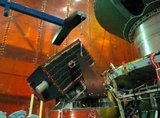
Seminar Nasional Kebijakan Penerbangan dan Antariksa III (SINAS KPA-III) 2018

                    Table 3-1.: ASEAN countries satellite technology’s current and future (red)
                                          program scale indicators

            Country               Indonesia       Malaysia      Philippines     Vietnam   Singapore   Thailand
   Start of program                                   X                                      X           X
   Investment                                         X                           X          X           X
   Technology mastering                X                                                     X
   Space agency                        X              X               X
   Technology partners                                                            X
   Total current scale                 2              3               0            1         3           2
   Total future scale                  2              3               1            2         3           2

3.2.    Emerging Space Countries : Possible ASEAN Collaboration

       The space technology pioneer countries, such as United States and Russia, use national defense and
national pride as the motivation for their space program. The countries started their program with launch
vehicle development, which considered dual-used or can be used for civilian (for satellite launcher) or
military purposes (as strategic weapons). This full-fledged approach require large investment to upgrade the
nations’ industrial capacity and human resources.

       The 2nd generation of space-faring countries, such as China, India, and European nations also uses the
same motivation to drive their space program, and therefore, adopting the full-fledged space program. The
different from the earlier space fairing generation are :
     1. The European nations have a join space agency to for their civilian launcher program.
     2. Germany and Japan does not built strategic weapons based on their satellite launcher technology,
          which is most probably due to post world-war II policies.
     3. India and China are less industrial developed nations when their space program was started.
          Therefore, the effort to built industrial and human resources capacity is far greater than others.

       As for the 3rd generation of space nations, there are two kinds of approaches that the countries done :
i.e. the ones that try to reach the status of space-faring nation, and the ones that conduct only satellite
development program and relying on space access from international market. The 1st approach is done by
Brazil (Globalsecurity, 2003) and South Korea (TASS, 2016). They intended to develop independent accces
to space, but at the moment still depend on their strategic partner, in this case Ukraine and Russia. The 2 nd
approach, which can be catagorized as partial space progam, since only develop satellite technologies, is
done by many countries, including South American countries like Bolivia and Argentina; ASEAN countries
as mentioned in chapter 2, and mediateranian countries Turkey (sputniknews, 2016) and Algeria (ASAL,
2016).

       By not building space launcher, the 3rd generation space countries that uses 2nd approach clearly
shows that their motivation is economy. Even the ones that built space launcher technology, have not
indicating that the technology acquisition will be used for strategic weapon. The countries that implement
partial space program usually driven by academic communities, which for ASEAN countries case highly
reflected in table 2-1. For ASEAN most countries case, the use of satellite technology public services is
highlited by establishing remote sensing agencies. The the use of satellite technology for economic benefit
is highlited by Singapore, which private company partcipated as soon as the academic finished with
technology acquisition phase.

        Table 2-2 and table 2-3 shows that the majority of the mission selected by the ASEAN countries are
land cover. Other mission they are interested is mapping and disaster mitigation. For such purpose, the
satellite payload required is multispectral imager and SAR. Therefore, technically, colaboration in satellite
program can be done among ASEAN countries, in the form of join (satellite) investment or data sharing. 3
                                                                 36
 36
Seminar Nasional Kebijakan Penerbangan dan Antariksa III (SINAS KPA-III) 2018

countries, i.e. Malaysia, Indonesia, and Singapore, have launched satellite to near equatorial orbit, which is
also a common interrest. However, only 2 of the ASEAN countries have space agency. This could lengthen
the collaboration effort since the legal base, and interest of the countries are different.

4.    CONCLUSIONS

        The study concludes that among the ASEAN countries that have satellite technology development
program, currently, Singapore and Malaysia are considered to have the largest program scale. Singapore got
its score from investment, program duration, and technology mastery, while Malaysia earn score in
investment, duration, and existence of space agency. In the near future, the program scale of Vietnam will be
in the same level with Indonesia and Thailand, due to its investment. For Indonesia, even though it has
technology mastering and space agency, but lack of investment made it unable to move beyond micro-
satellite program. For Thailand, even though the program has been initiated 20 years ago and significant
investment was done, the lack of space agency that could give future direction, halted the satellite technology
mastering process.

       Based on the space program strategy selected, the purpose of the ASEAN countries satellite program
is clearly civilian. The program will certainly give economic benefit and improvement in quality of human
resources in the country. Therefore, all of the countries’ program will be sustainable if not growing in scale.

       The potency for collaboration is high due to the countries’ common mission interest and ASEAN
economic bound. In such collaboration, the countries’ can also fill-up each other weakness, and strengthen
their position against space faring countries that consider them as technology market. The formality of such
collaboration, however, might be complicated due to different mode of institutional building in each country.

5.    ACKNOWLEDGEMENT

      Author wish to thank the Director of Satellite Technology Center, LAPAN, for supporting the
publication of this research. We thank also to the Director of Aerospace Policy Studies, LAPAN which has
given us opportunities to write and present this paper on SinasKPA III-2018 at Airlangga University,
Surabaya.

REFERENCES

ANTRIX, 2016, PSLV-C29 TELEOS-1 mission brochure, https://www.isro.gov.in/pslv-c29-teleos-1-
     mission/pslv-c29-teleos-1-mission-brochure.
Åström, H., 2015, South-East Asia: home to many growing industries, http://blog.entre.fi/2015/05/south-
     east-asia-home-to-many-growing-industries/, downloaded November 2017.
ASAL, 2016, Successful launch of the three Algerian satellites Alsat-1B, Alsat-2B and Alsat 1N,
     http://www.asal.dz/lancement-alsat-algerie.php , downloaded November 2017.
ATSB, 2014, http://www.atsb.my/index.php/project/space-systems/razaksatr.html, September 2014.
CRDS (Center for Research and Development Strategy), 2015, A Comparative Study on Space Technology
     in the World, Japan Science and Technology Agency.
GISTDA, 2017, The Government grants permission to make a progress on THEOS-2 satellite,
     http://www.gistda.or.th/main/en/node/1753.
Globalsecurity, 2003, President of Ukraine signs Decree on measures to ensure realization of Ukrainian-
     Brazilian       project     of      creating      space       rocket      complex      "Cyclone-4",
     https://www.globalsecurity.org/space/library/news/2003/174871293_mode.htm.
Hakim, P.R., Permala, R., Jayani, A.P.S., 2017, Acquisition performance of LAPAN-A3/IPB multispectral
     imager in real-time mode of operation, IOP Conf. Ser.: Earth Environ. Sci. 149 012061.
Hiramatsu, T., Shirasaka, S., Nakasuka, S., 2016, MicroDragon: a Vietnamese Ocean-observation
     Microsatellite Based on Hodoyoshi Architecture, The 7th Nano–Satellite Symposium, Kamchia,
     Bulgaria.

                                                       37                                                              37
Seminar Nasional Kebijakan Penerbangan dan Antariksa III (SINAS KPA-III) 2018

Hui,   C., 2017, ST Electronics to build 2nd Singapore-made Earth observation satellite,
      https://www.channelnewsasia.com/news/singapore/st-electronics-to-build-2nd-singapore-made-earth-
      observation-sat-7608664.
International Monetary Fund (IMF), 2017, Asia's Dynamic Economies Continue to Lead Global Growth,
      https://www.imf.org/en/News/Articles/2017/05/08/NA050917-Asia-Dynamic-Economies-Continue-
      to-Lead-Global-Growth, Januari 2018.
Kim, B. J., Park, S., Kim, E. E., Chang, H.S., W. Park, J. Seon, M. Ismail, A. Rasheed, A. S. Arshad, 2003,
      MACSAT - A Mini-Satellite Approach to High Resolution Space Imaging, Proceedings of AIAA/USU
      Conference on Small Satellites, Logan, USA.
M. Ansdell, L. Delgado López, D. Hendrickson, 2011, Analyzing the Development Paths of Emerging Space
      Nations: Opportunities or Challenge for Space Sustainability? Part of Master thesis at Space Policy
      Institute, Elliot School of International Affair.
Marciano, J. S., 2016, Development of the Philippine Scientific Earth Observation Microsatellite,
      presentation at Hokkaido Summer Institute, Hokkaido University, Japan.
Moed, H. and Halevi G., 2014, Tracking scientific development and collaborations – The case of 25 Asian
      countries, https://www.researchtrends.com/issue-38-september-2014/tracking-scientific-development-
      and-collaborations-the-case-of-25-asian-countries/, Desember 2017.
NTU            Satellite        Research          Center,         2016,          X-SAT            Micro-satellite,
      http://www.sarc.eee.ntu.edu.sg/Research/Projects/Pages/XSAT.aspx.
Phuong, V. V., 2016, Satellite Development at VNSC, presentation at Hokkaido Summer Institute, Hokkaido
      University, Japan.
Restrepo-Echavarria, P., 2017, Tigers, Tiger Cubs and Economic Growth, https://www.stlouisfed.org/on-the-
      economy/2017/may/tigers-tiger-cubs-economic-growth, downloaded January 2018.
Roswintiarti, O., 2010, REDD‐Related Activities in Indonesia, Presentation at the 16th Asia-Pacific Regional
      Space Agency Forum (APRSAF-16), Thailand.
Sputniknews,        2016,     Turkey     Targets     2019     for    Launch      of      Indigenous    Satellite,
      https://sputniknews.com/middleeast/201601081032855249-turkey-build-indigenous-satellite/,
      downloaded Desember 2017.
Sweeting, M.N., Pookyaudom, S., 1997, TMSAT: Thailand's first microsatellite for communications and
      earth observation, Acta Astronautica, Volume 40, Issues 2–8, Pages 423-427.
TASS, 2016, Russian aerospace company to make booster for South Korean satellite,
      http://tass.com/science/1010457, downloaded Desember 2017.
TDA, 2016, Development of RAZAKSAT-2 Satellite, http://tda.my/icp_programmes/development-of-
      razaksat-2-satellite/, downloaded Desember 2017.
Triharjanto, R. H., Hakim, P. R., 2017, Review of Satellite Technology Development in Indonesian Space
      Agency Based on Its Technical Publications in 2012-2016, Proc. 68th International Astronautical
      Congress.
Triharjanto, R. H., Hasbi, W., 2015, Status and Scope of Micro-Satellites Development in Indonesia,
      Presentation at Workshop on Asian Micro-satellite Consortium, Sapporo, JAPAN.
Vongvivatanakij, S., 2008, THEOS / Land Surface Imaging, presentation at CEOS WGISS-25, Sanya,
      China,          http://wgiss.ceos.org/meetings/wgiss25/LSI_Session/2.26.16.05_CEOS_WGISS25-v0.1-
      080226.ppt , downloaded Desember 2017.
Via      Satellite,     2016,     ST      Electronics     Opens      New       Satellite     Systems     Center,
      https://www.satellitetoday.com/innovation/2014/08/19/st-electronics-opens-new-satellite-systems-
      center/, downloaded August 2016.
Woetzel,      J.,    2015,     How      Asia     can    boost     productivity     and      economic     growth,
      https://www.mckinsey.com/featured-insights/employment-and-growth/how-asia-can-boost-
      productivity-and-economic-growth, downloaded Desember 2017.

 38                                                              38
You can also read