Summer 2021 Volume 29 Number 3 - Minnesota Society of ...
←
→
Page content transcription
If your browser does not render page correctly, please read the page content below

F PROFES
               IE
                  T   YO           SIO                        Summer 2021   Volume 29 • Number 3
      OC

                                     NA
           S

                                         LS
    NESOTA

                                           URVEYORS
M IN

                           1953

                           Minnesota Surveyor | Summer 2021                                  1
Minnesota Society of
         Professional Surveyors
 an affiliate of NATIONAL SOCIETY OF PROFESSIONAL SURVEYORS
       AMERICAN CONGRESS ON SURVEYING AND MAPPING

                        MINNESOTA SURVEYOR
Minnesota Surveyor is the official publication of the Minnesota                                                                      Advertise in the
Society of Professional Surveyors. It is published quarterly and sent
to members and similar organizations on a complimentary basis.                                                                      Minnesota Surveyor!
Material published is copyrighted but may be reprinted without
permission as long as credit is given to the MSPS Minnesota Surveyor.                                                  More than 600 members of the surveying community in
All material must be submitted by the deadline noted for each issue,                                                   Minnesota read the award-winning Minnesota Surveyor
and should be directed to:
                                                                                                                       magazine. Advertising in the magazine is a great way to
                                                                                                                      reach that audience! Our online publication allows you to
                                                EDITORS                                                                           link from your ad to your website.

                                             John Freemyer
                                            Roderick Squires
                                                                                                                              2021 ADVERTISING RATES:
                                                                                                                              1/3 page
                                                ©2021 MSPS
                                                                                                                              (4.5” wide x 4.75” high)................ $120.00
Articles and columns appearing in this publication do not necessarily                                                         1/2 page
reflect the viewpoints of MSPS or the Minnesota Surveyor staff, but                                                           (7.5” wide x 5” high).....................$160.00
are published as a service to MSPS members, the general public and
for the betterment of the surveying profession. No responsibility is
                                                                                                                              Full page
assumed for errors, misquotes, or deletions in content.                                                                       (7.5” wide x 10” high).................. $300.00
                                                                                                                              Inside Front Cover
                                                                                                                              (7.5” wide x 5.25” high)................$410.00

       MSPS 2021 OFFICERS AND DIRECTORS
President .  .  .  .  .  .  .  .  .  .  .  .  .  .  .  .  .  .  .  .  .  .  .  .  .  .  . Preston Dowell
President-Elect .  .  .  .  .  .  .  .  .  .  .  .  .  .  .  .  .  .  .  .  .  .  . Chad Conner                         SUSTAINING MEMBERS Receive a 20% Discount!
Past President.  .  .  .  .  .  .  .  .  .  .  .  .  .  .  .  .  .  .  .  .  .  .  . Pat Veraguth
Secretary .  .  .  .  .  .  .  .  .  .  .  .  .  .  .  .  .  .  .  .  .  .  .  .  .  .  .  . Julie Groetsch
Treasurer .  .  .  .  .  .  .  .  .  .  .  .  .  .  .  .  .  .  .  .  .  .  .  .  .  . Mark Severtson
NSPS Governor .  .  .  .  .  .  .  .  .  .  .  .  .  .  .  .  .  .  .  . Marcus Hampton                                  Contact the MSPS Office, info@mnsurveyor.com for more
                                                                                                                     information. Send ads via email, preferably in high-resolution pdf
Director .  .  .  .  .  .  .  .  .  .  .  .  .  .  .  .  .  .  .  .  .  .  .  .  .  . Amanda Brustad                          format and in color, to info@mnsurveyor.com.
Director .  .  .  .  .  .  .  .  .  .  .  .  .  .  .  .  .  .  .  .  .  .  .  .  .  .  .  .  . Tim Holperin
Director .  .  .  .  .  .  .  .  .  .  .  .  .  .  .  .  .  .  .  .  .  .  .  .  .  .  .  .  . Denny Honsa
Director .  .  .  .  .  .  .  .  .  .  .  .  .  .  .  .  .  .  .  .  .  .  .  .  .  .  .  .  . Kory Thurnau
Director .  .  .  .  .  .  .  .  .  .  .  .  .  .  .  .  .  .  .  .  .  .  .  .  .  .  .  .  .  .  .  . Jesse Zeig

           Minnesota Surveyor | Summer 2021                                                                                                                                           3
Index
     From the President, Preston Dowell....................................................5
     From the NSPS Director, Marcus Hampton..........................................6
     Call For Next Events Committee Chair...............................................7
     Surveying Education at Dunwoody College of Technology................7
     Footsteps …. The Land Ordinance of 1785..........................................8
     Legal Description Interpretation A Brief Examination of Minnesota
     Case Law.............................................................................................24
     Firm Member Directory......................................................................28
     Sustaining Members...........................................................................29
     Peter W. Blethen, LS, Memorial Scholarship......................................30

              Minnesota Surveyor Upcoming Content Deadlines
      Issue		                                     Due Date		                   Publication Date
      Fall 2021		                             October 1, 2021                    October 2021
      Winter 2021-22		                        January 1, 2022                    January 2022
      Spring 2022		                             April 1, 2022		                    April 2022
      Summer 2022		                             July 1, 2022		                     July 2022

Minnesota Surveyor | Summer 2021                                                                               4
From the President
Preston Dowell
                          Does this sound familiar? Question from a well-meaning friend: So, are you
                          staying busy?
                          Answer from a land surveyor: I have work coming out of my ears, I am three weeks
                          behind and I haven’t seen my kid's baseball game in a month. Is there anything
                          important we need to talk about because I’m too busy to breathe.
                          When the COVID pandemic hit last year, we all thought surveying would be the
                          first thing to go. But instead low interest rates, the great relocation and people
                          paying more attention to where their neighbor’s dog goes to the bathroom has
                          caused the surveying industry to go bananas. I have no scientific data here, but I
also think it has led to a lot of burnout in our industry.
The American Psychological Association has some tips on managing stress:
•   Track your stressors                                • Learn how to relax
•   Develop healthy responses                           • Talk to your supervisor
•   Establish boundaries                                • Get some support
•   Take time to recharge
It’s easier said than done, but I find taking time to relax and recharge to be an extremely effective way to
manage my stress. 12 years ago I took my first trip into the Boundary Waters Canoe Area Wilderness and it
opened my eyes to how effective relaxation could be.
I had no cell phone service, no radio and no way to communicate with the outside world. Of course I
fretted about work, family and other responsibilities. After 2 days, I realized that there was nothing I could
do except enjoy the moment I was in. Even after paddling and portaging over 50 miles in 5 days I came
back to work rejuvenated.
No, none of my projects magically got completed while I was gone. I still had to make up the week I missed
as well as get my new projects rolling. But I was prepared to take on the challenge with a renewed sense
of purpose.
I now go into the boundary waters a couple times a year. I consider myself lucky to have a wife and
employer that are supportive of my stress reliever.
I know it's summer and getting away feels impossible but if you have the opportunity to unplug and leave
work behind you for a couple days, take it. I don’t think you’ll regret it.
Here’s another idea, the MSPS Summer Meeting is being hosted by Chapter 5 at the Little Crow Golf Resort
in Spicer. This meeting is open to all MSPS members and is always a lot of fun. It’s a great way to get to
know other MSPS members in a relaxed setting. They are planning a golf outing, boat ride and an evening
banquet on Thursday August 19th. On Friday, there will be 3 PDH sessions.
So if you can’t take a vacation, maybe you can justify a work trip to get a couple PDHs and catch up with
some of your surveying counterparts. Who knows, you may “accidentally” forget your cell phone in the
hotel room for a couple hours.

    Minnesota Surveyor | Summer 2021                                                                         5
From the NSPS Director
Marcus Hampton
NSPS has endorsed the RETAIN Act (S. 2166) introduced last month by Sen. Jim
Inhofe (R-OK). Current co-sponsors include Tammy Duckworth (D-IL), Mike
Rounds (R-SD), and Jack Reed (D-RI). Please contact both of your U.S. Senators
to request co-sponsorship of this legislation which tackles the issue of GPS
interference by Ligado (formerly Lightsquared).
For more information, click here to watch the training webinar recorded July 13
featuring NSPS Executive Curtis Sumner and Registered Lobbyist John “JB” Byrd.
Individual NSPS members, as well as state society staff and leadership should
mobilize to support this important legislation. Click here for bullet points for use
when you call your U.S. Senators or when sending letters or emails to their offices.
Remember to ask for action by your U.S. Senators! “Will you co-sponsor S. 2166?” If needed, you may
contact John “JB” Byrd with any questions as you prepare and conduct outreach to U.S. Senators via his
email: jbyrd@mwcapitol.com
The NSPS Fall Business Meeting will take place September 22-25 at the Hyatt Lodge in Oak Brook, IL. A
PAC golf outing will be held at the Oak Brook Golf Club on September 22. For more information or to
register, visit the NSPS website.
For more information about anything NSPS-related, please visit the NSPS website. The website is updated
regularly and has a lot of industry-specific content. Anything else, feel free to reach out to me.
Respectfully submitted,
Marcus Hampton, LS
NSPS Governor
NSPS OBJECTIVE
The objective of this association is to unite all the registered land surveyors in the State of M
innesota, to elevate the
standards of the surveying profession in the State of Minnesota; to e stablish basic minimum requirements for surveys, to
assist in promoting legislation and educational programs to improve the professional status of the land surveyor; to work
in cooperation with local, county and state governments in our field of endeavor; to uphold a rigid code of ethics and
strive to improve our relations with our clients and the public by work with precision and integrity.
Minnesota Surveyor | Summer 2021 6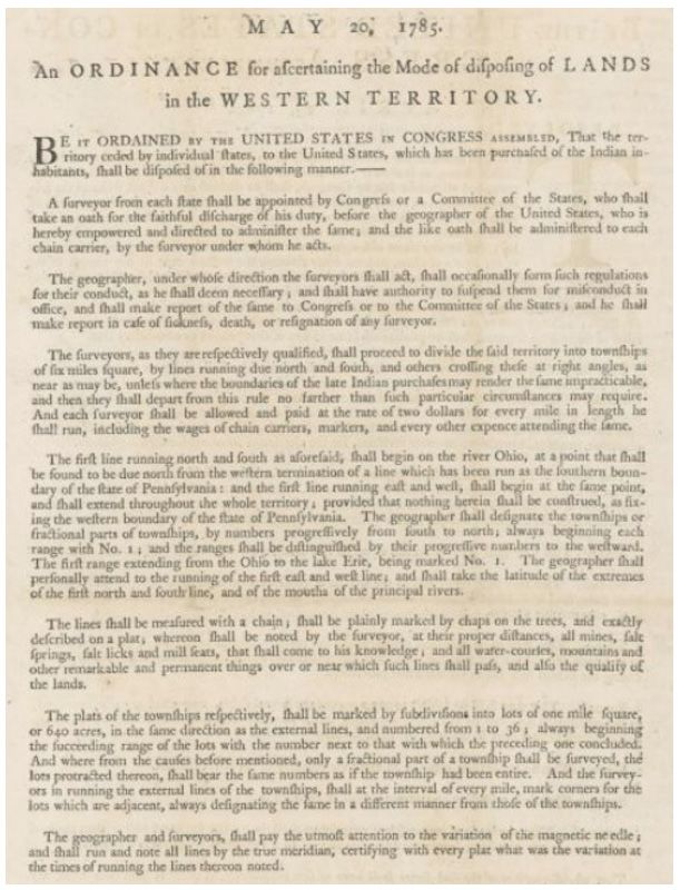
Call For Next Events Committee Chair
The MSPS Board of Directors and Events Committee are
looking for the next volunteer Events Committee Chair.
Role of the Committee and Chair
   • Establish the planning, financing and administration
     of the Annual Meeting and present a plan and
     detailed budget to the Board of Directors prior to
     preparation of budget.
   • Select suitable speakers for the Annual Meeting.
   • Solicit exhibitors and arrange for exhibits (exhibits chair).
   • Assure that appropriate Society business is conducted at the Annual Meeting, including
     elections, reports, bylaw amendments and resolutions.
   • Assist and work closely with the Society's Executive Director, who is assigned the detailed
     coordination of all Annual Meeting activities, functions and arrangements.
   • Provide membership with opportunities to study and learn, in a timely way, subjects of interest.
   • Recommend appropriate topics for workshops/seminars to the Board.
   • Coordinate agendas, speakers, costs and presentation requirements.
   • Assist and work closely with the Executive Director, who is assigned the detailed coordination of
     workshop/seminar facilities planning, mailings, registration, etc.
   • Advise the Board of Directors of workshop planning with a memo prior to each workshop.
   • Provide encouragement, education, and information to Survey Technicians interested in
     becoming a CST.
If you are interested in this position please send your inquiry to info@mnsurveyor.com or call the MSPS
headquarters at (952) 479-4204.

Surveying Education at Dunwoody
College of Technology
Dunwoody College of Technology is seeking to hire a faculty member to teach in its Surveying and Civil
Engineering Technology major program that prepares students for careers in land surveying or civil
engineering. The program is aligned with NCEES standards and students in the certificate may qualify to
sit for the Fundamentals of Surveying exam.
The position is advertised here: Faculty - Surveying/Civil Engineering (paycomonline.net)

    Minnesota Surveyor | Summer 2021                                                                      7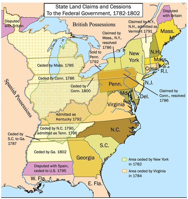
Footsteps …. The Land Ordinance of 1785.
Rod Squires, Emeritus University of Minnesota
Introduction
In this article, the first on specific historic documents that are of special importance to land surveyors,
I briefly describe the actions of the United States government in adopting legislation establishing some
principles under which approximately 60% of the land surface in the United States would be surveyed.
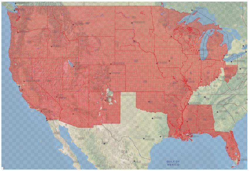
(Fig. 1)
Figure 1. Area covered by the rectangular land surveys funded by the United States government.1
Very few documents arise out of thin air. The Land Ordinance of 1785 was formulated from past practices
concerned with more than subdividing the land in a part of the United States that was sparsely settled and
largely unknown by the citizens of a new nation. Here I will concentrate on those parts of the Ordinance
that concern surveying.
This is by no means an exhaustive description. William D. Pattison has written one of the best accounts
of the Congressional debates concerning the Ordinance and the early rectangular land surveys in the
“Beginnings of the American Rectangular Land Survey System, 1784-1800,” which should be required
reading for land surveyors.2 I draw heavily on his work and the sources that he used.
The area surveyed under the provisions of the Land Ordnance was quite limited. (Fig.2) The importance
of the Ordinance, however, was seminal; as C. Albert White stated, it “laid a basis for a system of surveys
that could be improved and refined as better equipment and funding became available.”3
Minnesota Surveyor | Summer 2021 8
Figure 2. Area surveyed under the provisions of the Land Ordinance.4
The Land Ordinance of 1785
The Treaty of Paris, signed by representatives of King George III of Great Britain and representatives of
the United States of America on September 3, 1783 and ratified by the Continental Congress on January
14, 1784, officially ended the American Revolutionary War.5 In the Treaty Great Britain ceded jurisdiction
over an area and its inhabitants that included its former colonies – New Hampshire, Massachusetts Bay,
Rhode Island and Providence Plantations, Connecticut, New York, New Jersey, Pennsylvania, Delaware,
Maryland, Virginia, North Carolina, South Carolina, and Georgia – and also an area between the River
Ohio and the Mississippi River, the so-called “western territory” which was claimed by a few of the former
colonies.6 (Fig. 3)

    Minnesota Surveyor | Summer 2021                                                                     9
Footsteps …. The Land Ordinance of 1785.

                            Figure 3. State land claims and cessions, 1782-1802.7
This area, lying beyond the recognized boundaries of any government, was populated by indigenous
peoples and individuals who had acquired title to land via a grant from an antecedent sovereign, for the
most part France or Great Britain. The Continental Congress was faced with a number of problems but I
will focus on those concerning the western lands in 1784 and 1785.
In 1874,
   The cessions of western lands and a government for the new territory to be organized from them
   became matters of importance, but they were not carried far toward solution during 1784. Obtaining
   possession of the frontier posts from the British and the measures for garrisoning them by United
   States troops created the problem of a standing army, and Indian affairs became inextricably
   entangled with the military aspect of this problem.8 (Fig. 4)

   Minnesota Surveyor | Summer 2021                                                                     10
Figure 4. The Contents Page of Volumes 26 and 27 the Journals of the Continental Congress, 1784.9
This statement was not entirely true, however. On March 1, 1784, a committee appointed by the Continental
Congress to prepare a plan for the temporary government of the western territory, comprising Thomas
Jefferson from Virginia, Jeremiah Townley Chase from Maryland, and David Howell from Rhode Island,
introduced a report that described how new states would be established beyond the boundaries of the
original states, linking their establishment to the number of free male settlers “of full age.”10 The report
was amended and subsequently adopted by the Congress on April 23, 1784.11 The suggested boundaries of
the proposed states “comprised a framework for the anticipated operation of the first proposed national
land ordinance.”12
The following month, on April 30, a committee, consisting of Jefferson, Howell, Hugh Williamson from
North Carolina, Elbridge Gerry from Massachusetts, and Jacob Read from South Carolina, reported “An
ordinance for ascertaining the mode of locating and disposing of lands in the west territory, and for other
purposes therein mentioned” to the Congress, which would morph into the Land Ordinance over the next
13 months. Only the first part is relevant to the rectangular land surveys, the remainder of the proposed
ordinance being concerned with the disposal of the surveyed lands. The report began,
Minnesota Surveyor | Summer 2021 11Footsteps …. The Land Ordinance of 1785. (T)he territory ceded by individual States to the United States, when the same shall have been purchased of the Indian inhabitants, and laid off into states, shall be disposed of in the following manner. It shall be divided into Hundreds of ten geographical miles square, each mile containing 6086 feet, and four tenths of a foot, by lines to be run and marked due North and South, and others crossing these at right angles, the first of which lines, each way, shall be at ten miles distance from one of the corners of the State within which they shall be.13 But if the Indian purchase shall not have included any one of the corners of the State, the line shall then be run at the termination of integral miles, as measured from some one of the corners, but shall be extended, by actual marks, only so far as the purchase extends. These Hundreds shall be sub-divided into lots of one mile square each, or 850 acres and four tenths of an acre, by marked lines, running in like manner due north and south, and others crossing these at right angles.14 For laying off the said territory, Surveyors shall be appointed by Congress, or the Committee of the States, who shall proceed forthwith, under the direction of the Register hereafter to be mentioned, to divide the same into hundreds, by lines in the directions, and at the intervals before mentioned; which lines shall be measured with a chain, shall be plainly marked by chaps or marks on the trees, and shall be exactly described on a plat, whereon shall be noted, at their proper distances, all water courses, mountains and other remarkable and permanent things, over or near which such lines shall pass. The Hundreds being laid off and marked, nine of them shall be assigned as a district to each surveyor, who shall then proceed to divide each Hundred of his district into lots as before directed, beginning with the Hundreds most in demand, and measuring, marking and platting the said dividing lines thereof in the manner before directed for the Hundreds; save only that the lines of the lots shall be distinguished by a single mark on each tree, and those of the hundreds by three marks. And that the said lots may be capable of hundred more accurate description and distinction from each other, those in every hundred shall be designated by the numbers in their order, from 1 to 100, beginning at the northwestern lot of the hundred, and applying the numbers from 1 to 10, to the lots of the first row from west to east successively; those from 11 to 20, to the lots of the second row from West to East and so on. The Surveyors shall pay due and constant attention to the variation of the magnetic meridian, and shall run and note all lines by the true meridian, certifying with every plat what was the variation at the time of running the lines thereon noted.15 On May 7, 1784, a Friday, the Congress held the first reading of the ordinance and ordered a second reading for the following Monday.16 Importantly, on the same day Jefferson was appointed minister plenipotentiary to France and so was no longer involved in crafting the proposed legislation.17 The second reading was delayed. At the time, there was concern about the ability of Congress to consider all the matters that were before them before it was to adjourn. A committee appointed to report on the issue wrote, Your Committee having considered the fixed determination of Congress to adjourn on the 3rd June next, the short time which Congress now have to consider the matters requisite to be passed on before the adjournment; the impracticability of effecting this, unless debates are in a great measure dispensed with, or at least greatly reduced, and the injury that may result to the publick (sic) from not improving with assiduity the time preceding the adjournment, are of opinion that it will be necessary in this instance.18 Minnesota Surveyor | Summer 2021 12
The Ordinance proposed by the Jefferson committee was ranked among the most important measures.
However, when it was brought before Congress on May 28 the body voted not to consider it 19-4.19 Howell
and Williamson from the committee and three other representative voted in the affirmative, but Gerry
and Read from the committee and a majority of Congress members voted no.20 So the Ordinance was
necessarily held over until the next session of the Congress
The Land Ordinance was read for the first time in the new legislative session on March 4, 1785 and the
following Tuesday set for a second reading.21 On March 16, the ordinance was read a second time and
referred to a new committee consisting of a member from each state.22 Pattison remarked,
   Behind the determination of Congress to reach agreement and enact a land ordinance lay the hope
   of removing burdensome public debt. It might be observed, in this connection, that the question
   of land disposal was no longer coupled, in 1785, with the problem of government in the West. With
   the latter concern temporarily disposed of, by the Ordinance of 1784, the new land ordinance found
   itself sharing congressional attention with the almost desperate problem of federal finances.23 (Fig.
   5)

   Figure 5. The Contents Page of Volumes 28 and 29 of the Journals of the Continental Congress, 1784
On April 12, the new “grand” committee reported “An Ordnance for ascertaining the mode of disposing
of lands in the Western territory.”24 It was very different from the first Ordinance proposed by Jefferson’s
committee, stating,
   the territory ceded by individual States to the United States which has been purchas'd of the Indian
   inhabitants, shall be dispos'd of in the following manner:
   Thirteen or more surveyors shall be appointed by the Geographer of the United States who shall

    Minnesota Surveyor | Summer 2021                                                                       13
Footsteps …. The Land Ordinance of 1785. be approved of by Congress and who shall enter into bond with good security, the sufficiency of which shall be determined by the said Geographer conditioned for the faithful discharge of their duty respectively [Congress who shall take an Oath for the faithful Discharge of their Duty to be administered by the Geographer who is hereby impowered (sic) to administer the same] and if any surveyor being [appointed shall be unable to act from any cause whatever as afsd. shall decline or become incapable to discharge his Duty] the Geographer shall appoint another in his place. The Geographer (under whose direction the said surveyors shall act) shall form such regulations for their conduct as he shall deem necessary, and shall have authority to suspend them from Office until Congress shall be informed thereof to direct the proper inquirys [for misconduct in Office and shall make Report of the same to Congress.] The Surveyors shall proceed to divide the said territorys into townships of seven miles square, by lines running due North and South and others crossing these at right angles, unless where the boundaries of the late Indian purchase may render the same impracticable, and then departing from this instruction Rule no farther than such particular circumstances may require. The Geographer shall be allowed dollars p annum for his salary. There shall be allowed for the surveying of every township dollars, including the wages of chain carriers, markers and every other expense and so in proportion for a part of a township. The first Line running North and South as aforesaid shall begin on the Ohio, at a point that shall be found to be due North from the termination of a line which has been run as the Southern boundary of the State of Pennsylvania, and the first line running East and West shall begin at the same point, and shall extend throughout the whole territory. The Geographer shall designate the Townships or parts of townships by numbers progressively from South to North, always beginning each Range with No. 1 [and the Ranges shall be distinguished by their progressive numbers to the Westward, the first Range extending from the Ohio to the Lake Erie, being marked No. 1.] The lines shall be measured with a chain, shall be plainly marked by chops on the trees and exactly described on a plat whereon shall be noted at their proper distance all water courses, mountains and other remarkable and permanent things over or near which such lines shall pass. The Plats of the districts respectively shall be subdivided [as the Case may require] into sections of one mile square, or 640 acres, in the same direction as the external lines, and numbered from one to 49, always beginning the succeeding range of sections with the number next to that with which the preceeding (sic) one concluded and where from the causes before mentioned only a part of a township shall be surveyed, the sections protracted thereon shall bear the same numbers as if the Township had been intire (sic) [and those Sections shall be subdivided into Lots of 320 as.] The Geographer and surveyors under his direction shall pay the utmost attention to the variation of the magnetic needle, and shall run and note all lines by the true meridian, certifying with every platt (sic) what was the variation at the times of running the lines thereon noted.25 For over a month Congress considered the report. One member of the committee, David Howell, who had also been a member of Jefferson’s committee, commented that the land ordinance was “the most complicated and embarrassing subject before Congress since peace had taken place.”26 Minnesota Surveyor | Summer 2021 14
On April 26, 1785, Congress “proceeded to consider the Ordinance for ascertaining the mode of disposing
of Lands in the Western Territory, which is in the following words,”
   (T)he territory ceded by individual states to the United States, which has been purchased of the
   Indian inhabitants, shall be disposed of in the following manner:
   A surveyor from each state shall be appointed by Congress, who shall take an oath for the faithful
   discharge of his duty, to be administered by the geographer of the United States, who is hereby
   empowered and directed to administer the same.
   The geographer, under whose direction the surveyors shall act, shall form such regulations for their
   conduct, as he shall deem necessary, and shall have authority to suspend them for misconduct in
   office, and shall make report of the same to Congress.
   The surveyors shall proceed to divide the said territory into townships of seven miles square, by
   lines running due north and south, and others crossing these at right angles, unless where the
   boundaries of the late Indian purchases may render the same impracticable, and then they shall
   depart from this rule no farther than such particular circumstances may require.
   There shall be allowed for the surveying of a township at the rate of two dollars per mile, including
   the wages of chain carriers, markers, and every other expence, and so in proportion for every
   fractional part of a township.
   The first line, running north and south as aforesaid, shall begin on the Ohio, at a point that shall be
   found to be due north from the termination of a line, which has been run as the southern boundary
   of the State of Pensylvania; and the first line running east and west shall begin at the same point,
   and shall extend throughout the whole territory. The geographer shall designate the townships or
   parts of townships, by numbers progressively from south to north, always beginning each range
   with No. 1, and the ranges shall be distinguished by their progressive numbers to the westward.
   The first range extending from the Ohio to the lake Erie, being marked No. 1.
   The lines shall be measured with a chain; shall be plainly marked by chaps on the trees, and exactly
   described on a plat, whereon shall be noted, at their proper distances, all mines, salt-springs and
   salt-licks that shall come to his knowledge, and all water-courses, mountains, and other remarkable
   and permanent things, over or near which such lines shall pass.
   The plats of the townships respectively, shall be marked by subdivisions into sections of 1 mile
   square, or 640 acres, in the same direction as the external lines, and numbered from 1 to 49. Always
   beginning the succeeding range of the sections with the number next to that which the preceding
   one concluded. And where, from the causes before-mentioned, only a part of a township shall be
   surveyed, the sections protracted thereon shall bear the same numbers as if the townships had
   been entire. And these sections shall be subdivided into lots of 320 acres.
   The geographer and surveyors shall pay the utmost attention to the variation of the magnetic
   needle: and shall run and note all lines by the true meridian, certifying, with every plat, what was
   the variation at the times of running the lines thereon noted.27

    Minnesota Surveyor | Summer 2021                                                                         15
Footsteps …. The Land Ordinance of 1785. On April 29 Congress adopted a resolution made by Williamson and seconded by Howell That the President write to the Supreme Executive of the several States at present unrepresented in Congress urging their them in the strongest terms to send forward their delegates to Congress because the necessity of the attendance of their Delegates in Congress as Business of the utmost great importance to the United States now under consideration under the Articles of Confederation cannot be completed without a fuller representation of the States.28 The resolution stated Whereas the requisition for the supplies of the present year, An Ordinance for disposing of Lands in the Western territory, and other business of great importance to the United States, is now under the consideration of Congress, and cannot be completed (sic) without a fuller representation of the States, Resolved, That the President write to the Supreme Executives of the several States, at present unrepresented in Congress, urging the necessity of the attendance of their Delegates in Congress.29 Most of the amendments proposed during the debate concerned the actual disposal of the surveyed land. Only one amendment concerning the survey seems to have been made. On May 3, one of the grand committee members, William Grayson from Virginia, proposed an amendment to the fourth section in the Ordinance to strike out these words, "seven miles square;" and insert "six miles square," an amendment that was not agreed to.30 A second motion, presumably an amendment, was also made by Grayson on the same day stated, The surveyors shall proceed to divide the said territory into Districts of eight miles square by lines running due N. & S. and others crossing these at right angles unless where the boundaries of the late Indian purchase may render the same impracticable, and then departing from this rule no farther than such particular circumstances may require. They shall again divide the said districts into townships of four miles square and those townships into quarters of two miles square, all which subdivisions shall be in the same direction as the lines of the district.31 No action was taken on this proposal, nor on others relating to land sales during the next two days of debate. On May 5 “the Ordinance as amended was read a second time” although the text is not included in the Journals.32 The following day the Ordinance was read for a third time and amendments were offered by Grayson, none of which were adopted. In one, he proposed to strike out the following clause: "The Surveyors shall proceed to divide the said Territory into Townships of six miles square, by lines running due north and south, and others crossing these at right angles, unless where the boundaries of the late Indian purchases may render the same impracticable, and then they shall depart from this rule no farther than such particular circumstances may require," And to insert the following “The Surveyors shall proceed to divide the said Territory into Townships of six miles square, by lines running due north and south, and others crossing these at right angles, and the said Townships into right angled parallelograms, of the dimensions of two miles by six miles, in the direction of North and South." Minnesota Surveyor | Summer 2021 16
And at the end of the clause for subdividing townships, to insert the following,
   "And the surveyors in running the external lines of the Townships and right angled parallelograms,
   shall mark corners at the distance of every half mile, for the lots and half lots, always taking care
   that the comers for the Townships shall be designated in a different manner from those of the lots;
   and those of the lots in a different manner from those of the half lots,"
The sentence would then read
   "The plats of the townships respectively shall be marked by subdivisions into lots of one mile
   square, or 640 acres, in the same direction as the external lines, and numbered from I to 36, always
   beginning the succeeding range of the lots with the number next to that with which the preceding
   one concluded. And where, from the causes before mentioned, only a part of a Township shall
   be surveyed, the lots protracted thereon, shall bear the same numbers as if the Townships had
   been entire; and these lots shall be subdivided into lots of 320 acres, and the Surveyors in running
   the external lines of the Townships, and right angled parallelograms, shall mark corners at the
   distance of every half mile for the lots and half lots, always taking care that the corners for the
   Townships shall be designated in a different manner from those of the lots; and those of the lots in
   a different manner from those of the half lots.33
On May 8 Grayson, described by Pattison as an expeditor, wrote to George Washington.
   The Ordinance for disposing of the Western territory has been under consideration ever since I
   wrote you last and has underwent several alterations, the most considerable of which is that one
   half of the land is to be sold by sections or lots, and the other half by entire Townships; and the
   dimension of each township is reduc’d to six miles; I now expect the Ordinance will be completed
   in a few days, it being the opinion of most gentlemen that it is better to pass it in it’s (sic) present
   form nearly, than to delay it much longer and incur the risqué (sic) of losing the country altogether.34
Continuing he described some of the difficulties in getting the legislation adopted
   (T)hough it will be far from being the best that could be made, yet I verily believe it is the best that
   under present circumstances can be procured: There have appeared so many interfering interests,
   most of them imaginary, so many ill-founded jealousies and suspicions throughout the whole, that
   I am only surpris’d the ordinance is not more exceptionable; indeed if the importunities of the
   public creditors, and the reluctance to paythem by taxation either direct or implied had not been so
   great I am satisfied no land Ordinance could have been procured, except under such disadvantages
   as would in a great degree have excluded the idea of actual settlements within any short length of
   time; This is not strange when we reflect that several of the States are averse to new votes from that
   part of the Continent and that some of them are now disposing of their own vacant lands, and of
   course wish to have their particular debts paid and their own countries settled in the first instance
   before there is any interference from any other quarter.35
Later in the letter he complained, “There has never been above ten States on the floor and nine of these
were necessary to concur in one sentiment, least they should refuse to vote for the Ordinance on it’s (sic)
passage.36

    Minnesota Surveyor | Summer 2021                                                                          17
Footsteps …. The Land Ordinance of 1785. On May 19 the third reading continued and an amendment regarding the sale of land was not accepted.37 The following day Congress finally passed “An Ordinance for ascertaining the mode of disposing of Lands in the Western Territory.” (Fig. 6) Be it ordained by the United States in Congress assembled, that the territory ceded by individual States to the United States, which has been purchased of the Indian inhabitants, shall be disposed of in the following manner: A surveyor from each state shall be appointed by Congress, or a committee of the States, who shall take an Oath for the faithful discharge of his duty, before the Geographer of the United States, who is hereby empowered and directed to administer the same; and the like oath shall be administered to each chain carrier, by the surveyor under whom he acts. The Geographer, under whose direction the surveyors shall act, shall occasionally form such regulations for their conduct, as he shall deem necessary; and shall have authority to suspend them for misconduct in Office, and shall make report of the same to Congress, or to the Committee of the States; and he shall make report in case of sickness, death, or resignation of any surveyor. The Surveyors, as they are respectively qualified, shall proceed to divide the said territory into townships of six miles square, by lines running due north and south, and others crossing these at right angles, as near as may be, unless where the boundaries of the late Indian purchases may render the same impracticable, and then they shall depart from this rule no farther than such particular circumstances may require; and each surveyor shall be allowed and paid at the rate of two dollars for every mile, in length, he shall run, including the wages of chain carriers, markers, and every other expense attending the same. The first line, running north and south as aforesaid, shall begin on the river Ohio, at a point that shall be found to be due north from the western termination of a line, which has been run as the southern boundary of the state of Pennsylvania; and the first line, running east and west, shall begin at the same point, and shall extend throughout the whole territory. Provided, that nothing herein shall be construed, as fixing the western boundary of the state of Pennsylvania. The geographer shall designate the townships, or fractional parts of townships, by numbers progressively from south to north; always beginning each range with number one; and the ranges shall be distinguished by their progressive numbers to the westward. The first range, extending from the Ohio to the lake Erie, being marked number one. The Geographer shall personally attend to the running of the first east and west line; and shall take the latitude of the extremes of the first north and south line, and of the mouths of the principal rivers. The lines shall be measured with a chain; shall be plainly marked by chaps on the trees, and exactly described on a plat; whereon shall be noted by the surveyor, at their proper distances, all mines, salt springs, salt licks and mill seats, that shall come to his knowledge, and all water courses, mountains and other remarkable and permanent things, over and near which such lines shall pass, and also the quality of the lands. The plats of the townships respectively, shall be marked by subdivisions into lots of one mile square, or 640 acres, in the same direction as the external lines, and numbered from 1 to 36; always beginning the succeeding range of the lots with the number next to that with which the preceding Minnesota Surveyor | Summer 2021 18
one concluded. And where, from the causes before mentioned, only a fractional part of a township
   shall be surveyed, the lots, protracted thereon, shall bear the same numbers as if the township
   had been entire. And the surveyors, in running the external lines of the townships, shall, at the
   interval of every mile, mark corners for the lots which are adjacent, always designating the same in
   a different manner from those of the townships.
   The geographer and surveyors shall pay the utmost attention to the variation of the magnetic
   needle; and shall run and note all lines by the true meridian, certifying, with every plat, what was
   the variation at the times of running the lines thereon noted.38

               Figure 6. A portion of the Land Ordinance relating to surveying operations.39
Since, one of the goals of the Ordinance, perhaps the main goal, was to reduce the national debt perhaps
it is fitting to finish the article with the following statement on the nation’s finances made by a grand
Committee, consisting of a representative from each state, including Howell and King who had also served
on the grand committee that reported the Ordinance. On July 18, 1785, the committee stated,
   (T)he committee are of opinion, that the states be reminded, that Congress have passed an ordinance
   for the survey and sale of the western territory of the United States, and that the proceeds thereof will

    Minnesota Surveyor | Summer 2021                                                                           19
Footsteps …. The Land Ordinance of 1785.
be applied as a sinking fund, to extinguish the principal of the domestic debt. Future requisitions
for interest on the domestic debt, will therefore be reduced in proportion as this fund may be
rendered productive. And while on this subject, the committee cannot forbear mentioning that of
the states claiming western territory, Massachusetts alone has made the expected cession during
the last year, they are therefore of opinion, that the subject be again presented to the attention of
the states which have not complied with so reasonable a proposition; and that they be once more
solicited to consider with candour (sic) and liberality, the expectations of their sister states, and the
earnest and repeated applications made to them by Congress on this subject.40
Conclusion
Today, it is hard to envision how this Ordinance was adopted given the differing attitudes and the
ambivalence of the delegates from the original states comprising the Continental Congress and the lack of
knowledge of the western territory. As a means of raising revenue, the Land Ordinance was not successful.41
Congress soon abandoned the idea of surveying and disposing of the land and turned to the private sector.
That story has been described by Pattison and White.42
Pattison summed up the “broader significance” of the surveys under the provisions of the Land Ordinance
as,
1. making basic contribution to the tradition of public land surveying,
2. promoting the settlement of the West,
3. improving the mapping of the West,
4. providing valuable sources of historical information.43
It is hard to dispute these assertions but I necessarily end with a statement from J. F. Hawes, once the
Principal Clerk of Surveys in the General Land Office,
The government system of surveying is in some respects peculiar and unlike any other, and no
adequate facilities have been afforded surveyors not employed in the public service to make
themselves acquainted with its rules and principles. Hence it is in many cases impracticable to
make instructions intelligible to the local surveyor, without first giving some explanations as to the
manner in which the public surveys are executed.44
____________________________________________
After considerable thought, I have decided to provide the hypertext links to references to which I think the
readers will have ready access. All such links were available on the web as I finish writing this article on
June 30, 2021
1
Buhay, Corey “Meet the New and Improved Public Land Survey System (PLSS) Map Layer.” I acknowledge
the map is geographically incorrect since it does not include Alaska, Hawaii, and Puerto Rico.
2
Pattison, William D. “Beginnings of the American Rectangular Land Survey System, 1784-1800.”
(University of Chicago, Dept. of Geography, Research Paper No. 50, 1957).
Minnesota Surveyor | Summer 2021 203
White, C. Albert. “A History of the Rectangular Surveys System.” (Washington D.C. Government Printing
Office, 1983) PDF Version p.18.
4
A Map of the Federal Territory from the Western Boundary of Pennsylvania to the Scioto River.
5
The colonies established the Continental Congress, which met from September 4, 1774 until March 2,
1789, first creating a temporary national government, then securing independence from Great Britain, and
finally writing a constitution that established a new form of government.
6
The former colonies, now states, claimed land under the provisions of various colonial charters from the
British crown, see Colonial Charters, Grants and Related Documents.
7
State cessions.
8
Journals of the Continental Congress, 1774-1789. Prefatory Note.
9
Journals of the Continental Congress vol.26 p.iii.
10
Journals of the Continental Congress vol. 26 p.118-120. Also see Report on Government for Western
Territory; March 1, 1784.
11
Journals of the Continental Congress vol. 26 p.274-279. The proposed amendments can be read in the
following pages of this volume p.142, p.247-252, p.255-260, p. 274-280. See Land Ordinance of 1784. For a
fuller description of this legislation, see “Beginnings of the American Rectangular Land Survey System,
1784-1800” p.15-36. The provisions of this Ordinance would subsequently be nullified by the Northwest
Ordinance adopted in 1787.
12
“Beginnings of the American Rectangular Land Survey System, 1784-1800” p.36
13
“The attempt to write the hundred into national land legislation was plainly the work of Jefferson.”
“Beginnings of the American Rectangular Land Survey System, 1784-1800.” p.44. For a description of
“hundreds,” an Anglo-Saxon system of land holding in England, see England Hundreds and “Beginnings
of the American Rectangular Land Survey System, 1784-1800.” p.43-46. Pattison saw their introduction as
“an attempt to stimulate the establishment of an institution of local government and to introduce decimal
division into the apportionment of land.” p.46.
14
Journals of the Continental Congress vol.26 p.324. Pattison suggested “This statement, despite its
unfamiliar hundreds and its unexpected quantities, contains the essence of our national rectangular
survey system.” “Beginnings of the American Rectangular Land Survey System, 1784-1800” p.38
15
Journals of the Continental Congress vol.26 p.324-325. On p.330 in this volume is the following footnote
“This report, in the writing of Thomas Jefferson.” See “Beginnings of the American Rectangular Land
Survey System, 1784-1800” p.68-81. Pattison stated that the report “strongly represented” Jefferson’s ideas
and devoted several pages justifying his opinion. However, he also stated “in the interests of justice” a letter
written by Hugh Williamson on July 5, 1784 was important and so called the plan the Jefferson-Williamson
plan, Id. p.38-39. Williamson had written to the Governor of North Carolina, "The plan for laying off and
settling the Western Territory you will find on the Journals. It has not been agreed to in Congress; but is
put on the Journals that the public may consider of it before the next meeting. This being our sheet anchor
is to be carefully managed. I think the plan proposed will prevent innumerable frauds and enable us to
save millions. The general object is to oblige the Surveyors to account for the land by parallels, dotts (sic)
Minnesota Surveyor | Summer 2021 21Footsteps …. The Land Ordinance of 1785.
and meridians. However as I happen to have suggested the plan to the Committee it is more than probable
that I may have parental prejudices in its favour. (sic) It has at least the merit of being original.” Letters of
Members of the Continental Congress vol.7 p.563-564. Pattison provided some important context for the
committee’s report. “Beginnings of the American Rectangular Land Survey System, 1784-1800” p.39-67.
16
Journals of the Continental Congress vol. 26 p.356.
17
Journals of the Continental Congress vol. 26 p.356.
18
Journals of the Continental Congress v.27 p.397.
19
Journals of the Continental Congress vol.27 p.446-453.
20
The table recording the votes can be seen on Journals of the Continental Congress vol.27 p.453.
Journals of the Continental Congress vol.28 p.114. In a Prefatory note to this session of Congress, the editor
21
of the Journals, John C Fitzpatrick, wrote, “The important domestic problem of the western territory, its
government and the mode of disposing of its western lands, consumed much time, but made slow progress.
As these western lands were almost the sole reliance of Congress in its struggle to obtain revenue, the
development of this question and the different pressures exerted are worthy of critical analysis. Journals
of the Continental Congress vol.28 p.v.
22
Journals of the Continental Congress vol.28 p.165. The new committee consisted of David Howell and
Hugh Williamson, both of whom had been on the earlier committee, along with Pierse Long from New
Hampshire, Rufus King from Massachusetts, William Samuel Johnson from Connecticut, Robert R.
Livingston from New York, Archibald Stewart from Virginia, Joseph Gardner from Pennsylvania, William
Henry from Vermont, John Henry from Maryland, William Grayson from Virginia, John Bull from South
Carolina, and William Houstoun from Georgia.
23
“Beginnings of the American Rectangular Land Survey System, 1784-1800” p.83.
24
Journals of the Continental Congress vol.28 p.251.
25
Journals of the Continental Congress vol.28 p.251-253. On p.256 is a footnote stating, “This draft, in the
writing of William Grayson, except the part in brackets which is in the writing of Hugh Williamson.”
Clearly the strikeouts in the text followed by language enclosed [ ] were amendments but there is no
further information.
26
“Beginnings of the American Rectangular Land Survey System, 1784-1800” p.82.
27
Journals of the Continental Congress v. 28 p.298-299.
28
Journals of the Continental Congress vol.28 p.319.
29
Journals of the Continental Congress vol.28 p.319.
30
Journals of the Continental Congress vol.28 p.327.
31
Journals of the Continental Congress vol.28 p.327.
32
Journals of the Continental Congress vol.28 p.340.
Minnesota Surveyor | Summer 2021 2233
Journals of the Continental Congress vol. 28p. p.342-343.
34
“Beginnings of the American Rectangular Land Survey System, 1784-1800” p.82-83. Letters of Members
of the Continental Congress vol.8 p.117-118
35
Letters of Members of the Continental Congress vol.8 p.118.
36
Letters of Members of the Continental Congress vol.8 p.118.
37
Journals of the Continental Congress vol. 28 p.370-373.
38
Journals of the Continental Congress vol. 28 p.375-377.
39
DOCSTeach. The online tool for teaching with documents, from the National Archives. Land Ordinance
of 1785 5/20/1785.
40
Journals of the Continental Congress vol. 28 p.547.
41
“The surveys on which Congress placed its hopes for the retirement of the public debt, in 1785, yielded
little more than one hundred thousand dollars. This amount, realized from the sale of land in the Seven
Ranges, was not forthcoming until more than two years after passage of the Lan Ordinance of 1785, and
it was not increased during the lifetime of that law. It was far from sufficient for even one year’s payment
on the principal and interest of the public debt.” “Beginnings of the American Rectangular Land Survey
System, 1784-1800”. p.155.
“Beginnings of the American Rectangular Land Survey System, 1784-1800”. p.169-184. “A History of the
42
Rectangular Surveys System.” p.24-29.
43
“Beginnings of the American Rectangular Land Survey System, 1784-1800”. p.155 and following pages.
44
Hawes, J. H. “Manual of United States surveying. System of rectangular surveying employed in
subdividing the public lands of the United States; also instructions for subdividing sections and restoring
lost corners of the public lands ….” (Philadelphia. J. P. Lippincott & Co. 1868). p.iv.
Minnesota Surveyor | Summer 2021 23Legal Description Interpretation A Brief Examination of Minnesota Case Law John E. Freemyer, L.S Preface The ability to properly interpret a record legal description is fundamental to retracing or marking land boundaries. Interpreting a clear and concise legal description can be relatively easy for a trained professional but can be difficult and frustrating if the description is ambiguous. Often the most ambiguous record legal descriptions are those that were written before higher professional standards for writing land descriptions were incorporated. Unfortunately, old ambiguous descriptions are frequently used with current title transfers because there is often a hesitation to reform a record legal description. In his book “Minnesota Boundary Law and Adjoining Landowner Disputes” 1989, Clinton McLagan wrote: “Surveyors should hesitate to call a description ambiguous and try to resolve ambiguities. However, it is poor practice to force descriptions to fit.” Most land surveyors would likely agree with that statement but deciding when to try resolving ambiguities while not force fitting a description can be a delicate balancing act. Consider the following description recorded in 1940. Beginning at the southwest corner of Section 1, Township 0, Range 0, Nowhere County, Minnesota; thence North 500.00 feet; thence East 500.00 feet; thence South 500.00 feet; thence West 500.00 to the point of beginning. Most land surveyors would agree the description is lacking some important recitals and is not entirely clear. Case law instructs that determining the intent of the parties to the original transaction is paramount, but that is not always easy. Retracing the boundary on the ground may provide evidence. Without supporting evidence, some may presume the boundary is a parallelogram based on the measured angle at the southwest section corner, but some courts have ruled that a directional of North followed by a directional recital of East implies a 90-degree angle. Although the example is similar to descriptions that can be readily found on record deeds, the most perplexing ambiguous descriptions are typically far more challenging. In these cases attempts should be made to resolve description ambiguities by determining the position of existing land boundaries as evidenced by surveyor markers, fences, building walls, etc., or by trying to locate the original surveyor’s drawing or notes. Depending on the complexity of a problematic legal description, land surveyors may well be advised to consult the client and suggest further consultation with a real estate attorney. Minnesota Supreme Court Decisions Understanding some of the basic principles that the courts have used to resolve ambiguous legal descriptions and boundary disputes is an essential interpretation aid. Below are some decisions of the Minnesota Supreme Court In Beardsley v. Crane, 52 Minn. 537; 54 N.W. 740 (1893) the court ruled that: “It is well settled that when the grant describes the premises by distinct and definite boundaries, from which the land may be located, no extrinsic or parol evidence can be resorted to for the purpose of controlling or varying the description. The boundaries must be got at by the calls in the deed, when they are definite and distinct.” Minnesota Surveyor | Summer 2021 24
When interpreting legal descriptions, that is one of the most important principles. While extrinsic evidence
cannot vary an unambiguous description, it must be recognized that an array of unwritten rights may
impact the claims of a land owner. In such cases land surveyors become gatherers of facts for potential
legal consideration.
In Colter v. Mann, 18 Minn 96 (1871) the court ruled that: “It is a general rule that what is most material
and most certain will control over that which is less material and less certain. That which is clear and
certain control what without it is wholly uncertain and senseless. If there be two descriptions of the land
conveyed, which do not coincide, the grantee is entitled to hold by that which will be most beneficial to
him. If there be a doubt as to the construction of a deed, it shall be taken most favorably for the grantee.
This case reinforces the rule that uncertainties in a deed description are generally decided in favor of the
grantee. It could be interpreted that land surveyors are given the latitude to decide the basic intent when
language is “uncertain or senseless, “ although any such decision would always be subject to further
consideration.
In Nicolin v. Schneiderhan, 37 Minn. 63; 33 N.W. 33 (1887) the court decided that: “Where a map or plat
is referred to in a conveyance, it becomes, for the purpose of the description and identification of the
land, a part of the deed; and, courses and distances must yield to monuments, visible objects, or natural
boundaries called for in the deed. Conveyances made with reference to a plat must be construed as
calling for boundaries depicted on said plat (such as bodies of water and streets), the same as if expressly
incorporated into the body of the deeds, and, under the familiar rule referred to, these must control the
distances.”
This is the premier Minnesota case for establishing the principle that “call” recitals whether to artificial or
natural boundaries, or to record lines or points will control the description. Likewise this case establishes
the principle that references to plats in a description effectively makes the plat a part of the description.
In Owings v. Freeman, 48 Minn. 483; 51 N.W. 476 (1892) the court decided that: “The rule that points or
boundaries made certain by fixed monuments are to be regarded, to the exclusion of inconsistent courses
and distances. We thus give effect to what must here be regarded as the more certain element in the
description of the last line of boundary, making it to terminate at the ‘point of beginning’ as the intended
terminal point, and disregarding the erroneous course and distance.”
This becomes another case that reinforces the principle that recitals for “fixed monument” or record points
such as the “point of beginning” as the description termination point will negate an “erroneous course or
distance” recital.
In Cogan v. Cook 22 Minn. 137 (1875) the court stated: “As a general rule the terms of a written instrument
are to be understood in their plain, ordinary and popular sense. But language may be ambiguous and used
in different senses…”
This is a prominent case in how fractional part descriptions are to be interpreted for aliquot parts of the
U.S. government surveys versus parcels not designated in those surveys. In other words, the term “half”
may mean half by area, but in other circumstances it is something entirely different.

    Minnesota Surveyor | Summer 2021                                                                         25
You can also read