Sunday, September 1, 2019 8:30 a.m. EDT - The Disaster Center
←
→
Page content transcription
If your browser does not render page correctly, please read the page content below
Sunday, September 1, 2019
8:30 a.m. EDT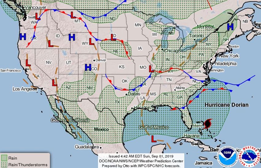
National Current Operations & Monitoring
 Significant Incidents or Threats:
 • Hurricane Dorian
 Tropical Activity:
 • Atlantic:
   o Hurricane Dorian
   o Disturbance 1: High (70%)
   o Disturbance 2: Low (30%)
   o Disturbance 3: Low (20%)
 • Eastern Pacific:
   o Tropical Storm Juliette
 • Central Pacific: No new tropical cyclones expected during the next five days
 • Western Pacific: No activity affecting U.S. interests
 Declaration Activity:
 • Emergency Declaration Approval – Seminole Tribe of Florida
Hurricane Dorian
Situation
• Dorian is a dangerous Category 5 hurricane, capable of causing life threatening storm
surge, extensive wind damage, and heavy rain from FL through eastern GA and coastal SC
and NC
• Although the exact NHC track forecast lies east of the Florida peninsula, a track closer to
the coast or even a landfall remains a possibility late Monday through Tuesday night
Potential Impacts – Southeastern U.S.
• Heavy rainfall and life-threatening flash floods possible across coastal sections of the
Southeast
o Coastal Carolinas: 5-10 inches, isolated 15 inches
o Atlantic coast from the FL Peninsula through GA: 2-4 inches, isolated 6 inches
• Surf: Large swells will affect the southeastern U.S. coast during the next few days; likely to
cause life-threatening surf and rip current conditions
Local Preparations/Response
• FL EOC: Full Activation
o Governor declared a state of emergency; National Guard fully activated
o Mandatory evacuation delayed until September 2 for Brevard and Martin counties
o Voluntary evacuations for Glades, Hendry, Martin, Palm Beach, Osceola, and St. Lucie
counties
o Airports:
FL airports closed to commercial flights only: Vero Beach and Daytona Beach
Orlando-Melbourne International Airport will close at 6:00 p.m. September 2
o Ports: Miami, Key West, and Port Canaveral open with restrictions; all other ports open
• Seminole Tribe of Florida EOC: Partial Activation; Tribal Chief declared state of emergency
• GA EOC: Full Activation: Governor declared a state of emergency
• SC EOC: Partial Activation; Governor declared a state of emergency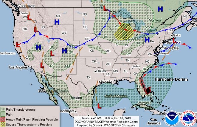
Hurricane Dorian
Federal Preparations/Response
• Emergency Declaration FEMA-3420-EM-Seminole Tribe of Florida
approved Aug 31, 2019
• Emergency Declaration FEMA-3419-EM-FL approved Aug 30, 2019
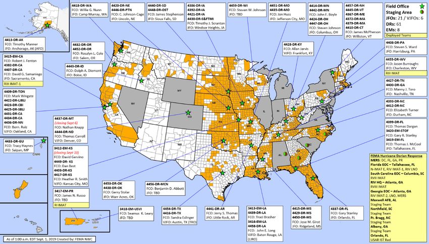
• NRCC: Level I, 24/7 with all LNOs and all ESFs
• Region IV RRCC: Level I, 24/7
• Region IV LNOs deployed to FL, GA and Seminole Tribe of Florida
o Region IV DCE Emergency Preparedness LNOs deployed to FL
EOC, RIV RRCC, Homestead ARB, North Auxiliary Field, Warner
Robins AFB, and Maxwell AFB
• Region III RWC: will go to Enhanced Watch at 8:00 a.m. EDT, Sep 2
• IMAT Teams deployed:
o National IMAT E deployed to FL EOC
o Region IV IMAT-1 to FL EOC; Region IV IMAT-2 to GA EOC
o Region VII IMAT redeployed from Region IV RRCC to SC EOC
o Region VIII IMAT deployed to Region IV RRCC
• ISB Teams: Logistics staging teams deployed to AL, GA, NC, and SC
• US&R:
o Red IST: Relocating to Orlando, FL
o 12 Task Forces, 4 Mission-Ready Packages – Water Rescue, and
1 HEPP activated
Declaration Approval
 Declaration: FEMA-3420-EM-Seminole Tribe of Florida
 Requested: Aug 30
 Approved: Aug 31
 Incident: Hurricane Dorian
 Incident Period: August 28, 2019 and continuing
 Includes:
 • PA: Emergency protective measures (Category B),
     limited to direct federal assistance for the Seminole
     Tribe of Florida
 FCO: Gary R. Stanley

                                                             PA
                                                             Tribal Areas
NWS Weather Prediction Center
Update #2, 5:00 am EDT Sunday, Sep 1, 2019

      5-Day Rainfall Forecast Through Early Friday, Sep. 6, 2019

                                                                   Heavy rain and flooding
                                                                   threat in the U.S.
                                                                   greatly depends on
                                                                   proximity of Dorian’s
                                                                   center to land

                                                                   Higher chances for
                                                                   heavy rainfall in coastal
                                                                   sections of the
                                                                   Carolinas in the mid-
                                                                   late week time frame
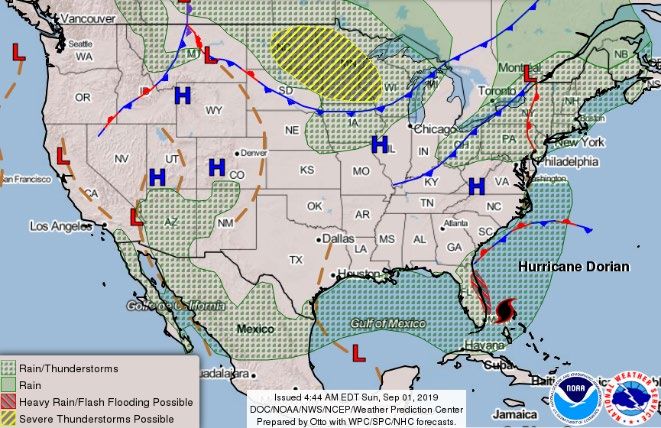
Tropical Outlook – Atlantic
 Hurricane Dorian (CAT 5) (Advisory #32A as of 8:00 a.m. EDT)
 • 255 miles E of West Palm Beach, FL
 • Moving W at 8 mph
 • Maximum sustained winds 160 mph
 • Should move closer to the FL east coast late Monday
   through Tuesday night
 • Expected to remain a powerful hurricane during the next
   few days
 • Hurricane force winds extend 30 miles; tropical-storm-force
   winds extend 105 miles
 • Tropical Storm Warning for north of Deerfield Beach to
   Sebastian Inlet
 • Tropical Storm Watch for north of Golden Beach to
   Deerfield Beach
Tropical Outlook – Atlantic
 Disturbance 1 (as of 8:00 a.m. EDT)
 • Located just south of Cabo Verde Islands
                                                                           3
 • Moving NW across eastern tropical Atlantic Ocean                       (20%)
 • Tropical depression likely to form by the middle of the week
 • Formation chance through 48 hours: Medium (50%)                 2
 • Formation chance through 5 days: High (70%)                    (30%)            1
                                                                                  (70%)
 Disturbance 2 (as of 8:00 a.m. EDT)
 • Located over south-central Gulf of Mexico
 • Moving slowly W
 • Formation chance through 48 hours: Low (20%)
 • Formation chance through 5 days: Low (30%)
 Disturbance 3 (as of 8:00 a.m. EDT)
 • Located several hundred miles SSE of Bermuda
 • Moving slowly N or NNW
 • Formation chance through 48 hours: Low (near 0%)
 • Formation chance through 5 days: Low (20%)
Tropical Outlook – Eastern Pacific Tropical Storm Juliette (Advisory #1 as of 5:00 a.m. EDT) • 455 miles SSW of Manzanillo, Mexico • Moving NW at 7 mph • Maximum sustained winds 45 mph • Tropical-storm-force winds extend 80 miles • Expected to become a hurricane on Monday
Tropical Outlook – Central Pacific
National Weather Forecast
                            Sun   Mon

                                  Tue
Severe Weather Outlook
Sun Mon
TuePrecipitation Forecast
Sun – Tue
Sun
Mon
TueFire Weather Outlook
http://www.spc.noaa.gov/products/fire_wx/fwdy1.html
Today TomorrowLong Range Outlooks – Sep 6-10
http://www.cpc.ncep.noaa.gov/products/predictio http://www.cpc.ncep.noaa.gov/product
ns/610day/610temp.new.gif s/predictions/610day/610prcp.new.gif
6-10 Day Temperature Probability 6-10 Day Precipitation ProbabilitySpace Weather
Space Weather Geomagnetic Solar Radio
Activity Storms Radiation Blackouts
Past 24 Hours Moderate G2 None None
Next 24 Hours Moderate G2 None None
For further information on NOAA Space Weather Scales refer to: http://www.swpc.noaa.gov/noaa-scales-explanation
HF Communication Impact Sunspot ActivityWildfire Summary
Fire Name Acres Percent Evacuations Structures Fatalities
FMAG #
(County, ST) Burned Contained (Residents) Threatened Damaged Destroyed Injuries
Gun Range Fire – FINAL
XXXX 321 (-44) 80% (+80%) Lifted 0 (-200) 3 (+1) 2 0 / 3 (+3)
(Davis County, UT)
Evacuations: M=Mandatory / V=Voluntary
Structures: H=Homes / O=OtherDeclaration Requests in Process – 6
State / Tribe / Territory – Incident Description Type IA PA HM Requested
LA – Flooding DR X X Aug 15
AR – Severe Storms and Flooding DR X X Aug 15
SD (+2 Tribes*) – Severe Storms, Tornadoes, and Flooding DR X X Aug 19
MI – Severe Storms and Flooding (Appeal) DR X X Aug 26
SD (+2 Tribes**) – Severe Winter Storms and Flooding DR X X Aug 28
IL – Severe storms and Flooding DR X X Aug 28
FL – Seminole Tribe of Florida (Approved Aug 31) EM X Aug 30
*Cheyenne River Reservation and the Lower Brule Indian Reservation
** Cheyenne River Reservation and the Rosebud Indian ReservationFEMA Common Operating Picture
FEMA HQ N-IMATs
2 Teams
NWC NRCC E FL
Monitoring Level I W
C
FEMA REGIONS R-IMATs
WATCH RRCC ≤ 3 Teams
Monitoring I Rostered I PR
Monitoring II Rostered II
Monitoring III Rostered III WV
Monitoring IV Level I IV-1 FL
Monitoring V Rostered IV-2 GA
Monitoring VI Rostered V
Monitoring VII Rostered VI-1
Monitoring VIII Rostered VI-2
Monitoring IX Rostered VII SC
Monitoring X Rostered VIII GA
Activation Details IX-1 CA
Region IV RRCC, 24/7
IX-2
Region III RWC to Enhanced
Watch, Sep 2 at 8:00 a.m. EDT X
FMC PMC
NMC Deployed
Team: US&R MERS FCOs FDRCs IM IM CADRE AVAILABILITY SUMMARY
Status (>36%) (>66%) (≤1 Type 1) (≥3) WORKFORCE Cadres with 25% or Less Availability
Assigned: 28 36 38 12 13,746 EHP 8% (47/560); ER 17% (12/71); FL 15% (23/154); FM 24% (67/285); HM 23%
Unavailable 2 0 2 1 4,012
(271/1201); HR 20% (44/224); IT 10% (65/655); LOG 17% (229/1,339); OPS 15%
Deployed: 16 11 (+8) 30 (-3) 8 (-1) 6,761
Available: 10 25 (-8) 6 (+3) 3 (+1) 2,973/ 22% (42/282); PA 11% (277/2,647); PLAN 15% (63/408); SAF 10% (6/61); SEC 21% (26/125)FEMA’s mission is helping people
before, during, and after disasters.
Click here to subscribe to this briefing.You can also read