July 27, 2018 Chatham County, GA EF-1 Tornado - National Weather ...
←
→
Page content transcription
If your browser does not render page correctly, please read the page content below
July 27, 2018 Chatham County, GA
EF-1 Tornado
Overview
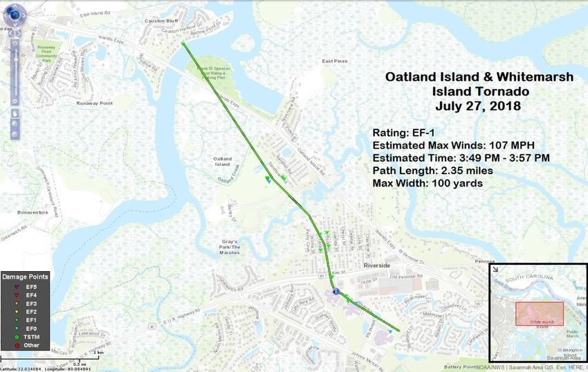
During the afternoon of Friday, July 27, 2018, an EF-1 tornado occurred in Chatham
County, GA. The tornado developed rapidly near Causton Bluff and traveled southeast
for a little more than 2 miles along a path up to 100 yards wide across parts of Oatland
and Whitemarsh Islands. During the 8 minute path, this tornado produced significant
damage to trees and buildings, including a few schools. Fortunately, there were no
injuries or fatalities. Refer to the Public Information Statement below for more details.
Meteorological Analysis
This tornado highlighted how conditions can change quickly in the vicinity of individual
thunderstorms. During the afternoon of July 27, the overall environment supported
numerous thunderstorms, and attention focused on the potential for gusty winds,
dangerous lightning and locally heavy rainfall – but the larger scale environment was not
supportive of supercells and tornadoes. However, as thunderstorm outflow collided with
the sea breeze, the local environment changed quickly – to an environment suddenly
supportive of thunderstorm rotation which immediately differed greatly from conditions
elsewhere across southeast Georgia. A thunderstorm developed, travelled southeast into
this new environment created by the colliding boundaries and began to spin. According to
radar data, only about 5 minutes elapsed from the beginning of this rotation to the time of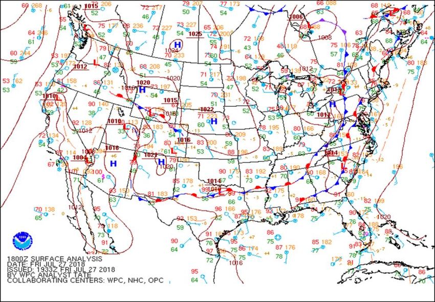
tornado touchdown. A loop of Charleston Doppler radar 0.5 degree reflectivity imagery
can be found here.

Because of the small-scale nature and rapid evolution of this altered environment, most
information available to meteorologists was unable to accurately depict the fine details
which can provide critical clues to the changing situation. However, the following
images offer some insight into the unique environment which abruptly but briefly
developed during the afternoon of July 27, 2018.

The Weather Prediction Center’s (WPC) surface analysis at 18Z (2 PM EDT) depicting a
  cold front across central SC/GA. Moisture focused ahead of this front supported an
     unusually active regime featuring numerous thunderstorms across our area.

The WPC surface analysis at 21Z (5 PM EDT) depicting a stationary front across central
      SC/GA. Overall conditions had not changed across our region since 2 pm.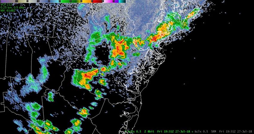
Charleston, SC Doppler radar 0.5 degree reflectivity image at 231 PM EDT depicting
numerous thunderstorms across southeast Georgia and adjacent areas of southeast South
  Carolina. Primary concerns with these thunderstorms included dangerous lightning,
 locally heavy rain and gusty winds. The overall environment did not support supercells
                                      or tornadoes.

 The Storm Prediction Center’s (SPC) meso-analysis at 19Z (3 PM EDT) depicting the
 Non-Supercell Tornado Parameter along the sea breeze near coastal SC/GA. This is a
common daily feature in our area. In this case, a thunderstorm moved southeast into this
            environment, setting in motion events which led to a tornado.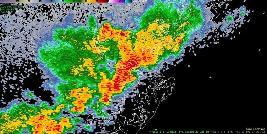
The SPC’s meso-analysis at 20Z (4 PM EDT) depicting no Significant Tornado
Parameter across coastal SC/GA. Meteorologists often use this parameter to anticipate
                 rotating thunderstorms and associated tornadoes.

The SPC’s meso-analysis at 19Z (3 PM EDT) depicting low but non-zero values of 0-1
  km Storm Relative Helicity (SRH – the potential for thunderstorm rotation) across
                                    coastal GA.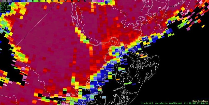
Thunderstorms
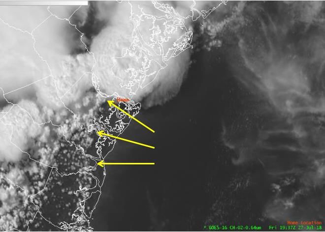
GOES-East Visible (Band 2) image of a mesoscale boundary marked by a line of cumulus
clouds over coastal southeast Georgia. At this time (337 PM EDT), thunderstorm outflow
from the west/northwest was colliding with the sea breeze. A rapidly developing
thunderstorm moved southeast into the altered environment created by this collision over
Chatham County, began to spin and produced a tornado beginning at 349 PM EDT.
Charleston, SC Doppler radar 0.5 degree storm-relative velocity (SRM) image at 1944Z
(344 PM EDT) indicating counter-clockwise rotation at around 2800 feet above the
ground near Causton Bluff in GA. Click here for a loop of several SRM images.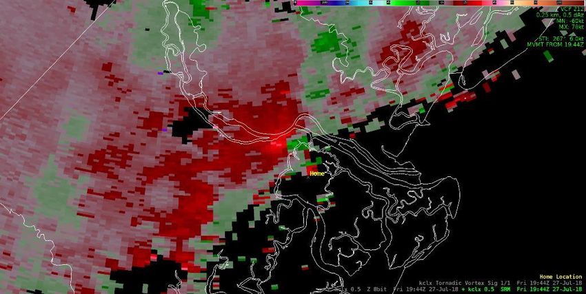
Charleston, SC Doppler radar 0.5 degree storm-relative velocity image at 1949Z (349
PM EDT) indicating counter-clockwise rotation at around 2900 feet above the ground
near the Oatland Island Wildlife Center in GA. The tornado was touching down at this
                 time. Click here for a loop of several SRM images.

 Charleston, SC Doppler radar 0.5 degree storm-relative velocity image at 1954Z (354
PM EDT) indicating counter-clockwise rotation at around 3000 feet off the ground near
the Oatland Island Wildlife Center in GA. The tornado dissipated about 3 minutes later.
                    Click here for a loop of several SRM images.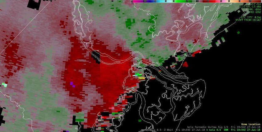
Charleston, SC Doppler radar 0.5 degree reflectivity (Z) image at 1959Z (359 PM EDT)
showing a “hook” pattern near the location of the tornado over Whitemarsh Island, GA.

 Charleston, SC Doppler radar 0.5 degree correlation coefficient (CC) image at 1956Z
 (356 PM EDT) showing lower values near the location of the tornado. Click here for a
  loop of several images. Lower values indicate the presence of non-spherical objects,
                      which in this case could be tornado debris.

Conclusions
As is typical for tornadoes in this part of the country, this particular tornado was
relatively short-lived and weak. Also, this tornado developed quickly as a result of a
thunderstorm interacting with the collision of two mesoscale convective outflow
boundaries. Such boundary collisions and thunderstorm interactions are commonplace
during the warm season and most of the time do not produce tornadoes – especially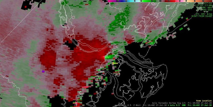
during late July. Furthermore, there exist inherent limitations with the Doppler radar and
other tools forecasters use to assess thunderstorm severity. These limitations are
magnified when the local environment abruptly and unexpectedly changes. In this case,
thunderstorms had been producing heavy rain, frequent lightning and gusty winds for
hours; then, a single thunderstorm suddenly begin to rotate and rapidly produced an EF-1
tornado. Meteorologists seek evidence that these sudden changes are accurate
observations; in a fast-breaking situation, the time available for this critical data
evaluation and warning decision process becomes exceedingly short.
Public Information Statement: Summary of Tornado Produced by
Storm Survey Team
Public Information Statement
National Weather Service Charleston SC
655 PM EDT Sat Jul 28 2018

...NWS DAMAGE SURVEY FOR 07/27/2018 TORNADO EVENT...

.Oatland and Whitemarsh Island Tornado...

Start Location...2 E Lepageville in Chatham County GA
End Location...1 SSW Riverside in Chatham County GA
Date...07/27/2018
Estimated Time...03:49 PM EDT
Maximum EF-Scale Rating...EF1
Estimated Maximum Wind Speed...107 mph
Maximum Path Width...100 yards
Path Length...2.35 miles
Beginning Lat/Lon...32.0644 / -81.0287
Ending Lat/Lon...32.0379 / -81.0053
* Fatalities...0
* Injuries...0

...Summary...
The tornado began near Bartow Point Drive, just north of Island Expressway. It then
crossed over the Frank W. Spencer Boat Ramp and Fishing Pier area before crossing
Island Expressway. The tornado continued southeast across Oatland Island, where it was
estimated to have snapped and uprooted over 100 large hardwood and softwood trees. It
also removed the roof from a log cabin and partially damaged the roof to another
structure in the Delk-Dawson Heritage Homestead on Oatland Island. The tornado
continued southeast over Richardson Creek, entering the Grays Subdivision on
Whitemarsh Island. In this neighborhood, the tornado snapped and uprooted many large
trees. The most significant damage surveyed in the Grays Subdivision were large snapped
and uprooted trees that had fallen onto approximately 50 homes. Several homes also had
significant shingle damage.
The tornado then crossed Highway 80, moving over Islands Christian Church before
taking a narrow path along Dolphin Lane, passing near Marsh Point Elementary school.
The elementary school sustained moderate damage to the roof near the main entry of the
facility. Finally, the tornado moved southeast across Whitemarsh Island Drive before
dissipating near Islands High School, where it toppled the metal bleachers and damaged
some fencing near athletic fields. The tornado lasted approximately 8 minutes, ending
around 357 PM EDT.

EF Scale: The Enhanced Fujita Scale classifies tornadoes into the following
categories:
EF0...Weak......65 to 85 mph
EF1...Weak......86 to 110 mph
EF2...Strong....111 to 135 mph
EF3...Strong....136 to 165 mph
EF4...Violent...166 to 200 mph
EF5...Violent...>200 mph

* The information in this statement is preliminary and subject to
change pending final review of the event and publication in NWS
Storm Data.

$$

RFM/DPB
You can also read