Sustainable Movement - South Dublin County Council
←
→
Page content transcription
If your browser does not render page correctly, please read the page content below

Sustainable
Movement
Vision
Increase the number of people walking,

                                                           Sustainable Movement (SM)
cycling and using public transport and
reduce the need for car journeys, resulting
in a more active and healthy community, a
more attractive public realm, safer streets,
less congestion, reduced carbon emissions,
better air quality, and a positive climate
impact.

DRAFT SOUTH DUBLIN COUNTY DEVLOPMNT PLAN 2022-2028   239
7.0 Introduction                                                                          7.1 Sustainable Movement and Climate Action
                            Movement is essential to how we live our lives and for society to function both           The national Climate Action Plan (2019) indicates that transport accounts for almost
                            socially and economically – for commuting to work, travel to school, social and leisure   one fifth of Ireland’s greenhouse gas emissions (figure from 2017). In the South Dublin
                            trips, and for the supply of goods and services. The private vehicle will always have     County area, data from the 2016 census indicates that 62% of journeys are by private
                            an important role to play in how people move around South Dublin. However, in             transport, which are mainly car-based trips. It is therefore clear that changing the way
                            recent decades traditional layouts with low density housing, distributor roads and        in which we move around to more sustainable modes including walking, cycling and
                            cul-de-sacs have resulted in people having to choose to drive for the majority of their   public transport has significant potential to help us tackle climate change by reducing
                            trips. This has created environments which are dominated by the car and where             emissions from transport. This chapter contains policies and objectives that seek to
                            distances to shops, bus stops, schools and workplaces are excessively long. This,         achieve this goal, and which will assist South Dublin County in achieving its climate
                            coupled with the lack of adequate provision for walking and cycling has resulted in an    action targets. There is also significant scope for movement and transport corridors
                            urban environment dominated by motorised traffic and often hostile to cyclists and        to form important links in the Council’s green infrastructure network as they provide
                            pedestrians. The dominance of car-based transport also has many adverse                   opportunities for additional and replacement planting of native species and
                            environmental and social impacts including traffic accidents, congestion, noise, and      pollinators, which will in turn contribute to biodiversity and carbon sequestration.
                            emissions with negative implications for air quality, health and climate change.          Policies contained in this chapter for an increase in EV charging facilities to
                                                                                                                      encourage the transition from petrol and diesel cars to electric vehicles will also make
                            Recent thinking in relation to development of sustainable towns and cities involves       a big impact on emissions and greatly reduce greenhouse gas emissions.
                            the ‘10-minute neighbourhood’ or the ‘connected neighbourhood’ concept, whereby
                            the services people need in their daily lives are located a short distance from their
                            home by walking or cycling. This concept facilitates active travel modes (walking and
                                                                                                                      7.2 Planning Policy Context
                            cycling) and the use of public transport resulting in more compact, vibrant and
                                                                                                                      Development Plan policies and objectives must be consistent with national and
                            walkable urban areas. This approach is echoed in national planning policy (the
                                                                                                                      regional planning policy as set out in the National Planning Framework (NPF) and
                            National Planning Framework) which has Compact Growth and Sustainable Mobility
                                                                                                                      Regional Spatial and Economic Strategy (RSES). A number of objectives in these
                            as key National Strategic Outcomes and regional planning policy (the Regional
                                                                                                                      documents are particularly relevant to the area of sustainable movement:
                            Spatial and Economic Strategy) which promotes more compact, higher density
                            neighbourhoods focussed on public transport nodes. In areas designed in this
                                                                                                                      àà National Strategic Outcome 4 of the NPF is Sustainable Mobility.
                            manner, people of all ages and abilities can choose to make short and medium length
                            trips by walking and cycling and it is easier and more economical for public transport
                                                                                                                      àà National Policy Objective 64 of the NPF states ‘Improve air quality and help
Sustainable Movement (SM)

                                                                                                                                                                                                                              Sustainable Movement (SM)
                            to operate to cater for medium and longer trips. More pleasant urban environments
                                                                                                                                      prevent people being exposed to unacceptable levels of pollution in our urban
                            are created where social and economic activity can thrive. The County Development
                                                                                                                                      and rural areas through integrated land use and spatial planning that supports
                            Plan reflects national and regional policy and incorporates compact growth,
                                                                                                                                      public transport, walking and cycling as more favourable modes of transport to
                            sustainable movement and the connected neighbourhood concept at the core of its
                                                                                                                                      the private car…’
                            approach to placemaking.

                                                                                                                      àà Chapter 5 of the RSES contains the Dublin Metropolitan Area Strategic Plan
                            Travel data for the County indicates that one quarter of trips under 3km and almost
                                                                                                                                      (MASP). Regional Policy Objective 5.2 of the MASP is to ‘Support the delivery of
                            half of trips under 6km are taken by car. There is significant scope for a shift to
                                                                                                                                      key sustainable transport projects including Metrolink, DART and LUAS expansion
                            walking and cycling for these shorter trips. However, to make this shift attractive to
                                                                                                                                      programmes, BusConnects and the Greater Dublin Metropolitan Cycle Network
                            people, changes to the environment are required to make walking and cycling easier
                                                                                                                                      and ensure that future development maximises the efficiency and protects the
                            – these changes include designing new development areas around active travel
                                                                                                                                      strategic capacity of the metropolitan area transport network, existing and
                            modes and public transport and building at higher densities. In existing areas,
                                                                                                                                      planned’.
                            measures to promote active modes and public transport include improving
                            pedestrian facilities by implementing measures such as widening footpaths and
                                                                                                                      àà Regional Policy Objective 5.3 of the RSES/MASP requires that ‘Future
                            enhancing surfaces, removing obstacles such as walls and railings in order to create
                                                                                                                                      development in the Dublin Metropolitan area shall be planned and designed in a
                            better permeability, and providing a network of safer cycle lanes. This County
                                                                                                                                      manner that facilitates sustainable travel patterns, with a particular focus on
                            Development Plan contains policies and objectives for healthy placemaking and
                                                                                                                                      increasing the share of active modes (walking and cycling) and public transport
                            sustainable movement that over time, will achieve an increase in walking, cycling and
                                                                                                                                      use and creating a safe attractive street environment for pedestrians and cyclists’.
                            use of public transport and a decrease in use of the private car.

                            240                                  DRAFT SOUTH DUBLIN COUNTY DEVLOPMNT PLAN 2022-2028   DRAFT SOUTH DUBLIN COUNTY DEVLOPMNT PLAN 2022-2028                                                241
There are many other national and regional policy objectives relevant to transport                           guidance on integrating cycling in the design of urban areas in order to create a
                            and sustainable movement, some of which are referred to within individual policies                           safe traffic environment for all road users and to encourage more people of all
                            and objectives in this chapter. A full list of national and regional policy objectives is                    ages and abilities to cycle.
                            set out within Appendix 7. The NTAs Strategy for the Greater Dublin Area is a key
                            policy document referenced below.                                                            The Council recognises that new development, both residential and commercial,
                                                                                                                         permitted in line with this Plan will lead to additional trips being generated. The
                                                                                                                         Council will work with the relevant agencies to seek to ensure that as high a
                            7.3 Overarching Policies and Objectives                                                      proportion as possible will be conducted by sustainable means. However, it is
                                                                                                                         accepted that a residual proportion of the trips generated will be taken by private
                            The social, economic and environmental wellbeing of South Dublin County and the
                                                                                                                         vehicle. The challenge is to ensure that this does not add to existing levels of
                            Dublin Region is dependent on the efficient and sustainable movement of people and
                                                                                                                         congestion or saturation of the road network.
                            goods within and through the County. An overarching policy is to rebalance transport
                            and mobility within the County by promoting ease of movement by sustainable
                            modes (including walking, cycling and public transport). This will provide for the                      Policy SM1: Overarching – Transport and Movement
                            freeing up of road space for essential functions such as, public transport and                          Promote ease of movement within, and access to South Dublin County, by
                            emergency vehicles. It will also allow for commercial transport which is essential to                   integrating sustainable land-use planning with a high-quality sustainable
                            economic growth. In doing so, the Council will continue to provide for all elements of                  transport and movement network for people and goods.
                            the transportation network that are within its remit and will engage with external
                            agencies including the National Transport Authority (NTA) and Transport                                 SM1 Objective 1:
                            Infrastructure Ireland (TII) to assist the delivery of sustainable transport projects that              To achieve and monitor a transition to more sustainable travel modes including
                            are provided at a regional or national level.                                                           walking, cycling and public transport over the lifetime of the County
                                                                                                                                    Development Plan, in line with the County mode share targets of 15% Walk; 10%
                            In preparing this County Development Plan, in addition to the policy documents                          Cycle; 20% Bus; 5% Rail; and 50% Private (Car/Van/HGV/Motorcycle).
                            outlined above, the Council has had regard to a number of strategic documents with                      SM1 Objective 2:
                            relevance to transport and movement including:                                                          To ensure consistency with the NTA’s Transport Strategy for the Greater Dublin
                                                                                                                                    Area (2016-2035) and any superseding document, as required by RPO 8.4 of
                            àà Transport Strategy for the Greater Dublin Area (2016-2035), National Transport                       the RSES.
                                  Authority: This document provides a framework for the planning and delivery of
                                  transport infrastructure and services in the Greater Dublin Area (GDA) over the                   SM1 Objective 3:
Sustainable Movement (SM)

                                                                                                                                                                                                                               Sustainable Movement (SM)
                                  strategy period. The strategy is currently being reviewed and South Dublin County                 To support the delivery of key sustainable transport projects including DART
                                  Council is participating in this process. An updated strategy will be prepared for                and Luas expansion programmes, BusConnects and the Greater Dublin
                                  the period up to 2042.                                                                            Metropolitan Cycle Network in accordance with RPO 5.2 of the RSES/MASP.

                                                                                                                                    SM1 Objective 4:
                            àà Climate Action Plan (2019), Department of the Environment, Climate and                               To ensure that future development is planned and designed in a manner that
                                  Communications: This document charts a course towards meeting EU emissions                        facilitates sustainable travel patterns, with a particular focus on increasing the
                                  reduction targets for Ireland to 2030, with a view to reaching the longer term                    share of active modes (walking and cycling) and public transport use and
                                  target of net zero emissions by 2050. Modal shift to walking, cycling and public                  creating a safe and attractive street environment for pedestrians and cyclists,
                                  transport is one of the main measures being promoted by the Action Plan to                        in accordance with RPO 5.3 of the RSES/MASP.
                                  achieve its targets for transport as well as building the EV charging network,
                                  conversion of the public fleet to EVs, and use of biofuels.                                       SM1 Objective 5:
                                                                                                                                    To ensure that future development is planned and designed in a manner that
                                                                                                                                    maximises the efficiency and protects the strategic capacity of the
                            àà    Design Manual for Urban Roads and Streets (2013; updated 2019), Department of
                                                                                                                                    metropolitan area transport network, both existing and planned, and to protect
                                  Transport, Tourism and Sport and Department of Environment, Community and
                                                                                                                                    and maintain regional accessibility, in accordance with RPO 8.3 of the RSES.
                                  Local Government: This document provides guidance relating to the design of
                                  urban roads and streets. The focus of the manual is on the fact that well-designed                SM1 Objective 6:
                                  streets can create connected physical, social and transport networks that promote                 To safeguard the County’s strategic road network and to improve the local road
                                  walking, cycling and public transport as real alternatives to car journeys.                       and street network in a manner that will better utilise existing road space and
                                                                                                                                    encourage a transition towards more sustainable modes of transport.
                            àà National Cycle Manual (2011), National Transport Authority: This document offers

                            242                                     DRAFT SOUTH DUBLIN COUNTY DEVLOPMNT PLAN 2022-2028   DRAFT SOUTH DUBLIN COUNTY DEVLOPMNT PLAN 2022-2028                                              243
parking at key destinations. Just over half of car-based trips are for distances of more
                              SM1 Objective 7:
                                                                                                                                 than 6km. Similarly, many of these trips could be undertaken by public transport.
                              To engage with relevant agencies including the National Transport Authority
                              (NTA) and Transport Infrastructure Ireland (TII) in relation to strategic and local
                              transportation issues including delivery of transport projects and to encourage
                              consultation with local communities.

                              SM1 Objective 8:
                              To prepare Integrated Transport Studies for urban areas within the County, as
                              need arises, to provide a long-term plan for the movement of pedestrians,
                              cyclists, public transport and private vehicles and to have regard to the
                              European Commission’s Guidelines for Developing and Implementing a
                                                                                                                                                                                          26%         23%
                                                                                                                                                                                                               51%
                              Sustainable Urban Mobility Plan (2nd Edition, 2019) in the preparation of such                                                                          0     3KM   3    6KM   6KM+
                              studies.

                                                                                                                                  Lengths of Car Journeys Originating in South Dublin County
                            7.4 Travel Mode Share
                            Data indicates that a significant majority of trips (62%) originating in South Dublin                Transition to public transport will be aided by improvements in the pipeline including
                            County are by private transport and are mainly car-based. Cycling accounts for a very                the roll-out of BusConnects which will include proposals for six new dedicated bus
                            small proportion of journeys at 5% while walking comprises 13% of trips.                             routes through the County. BusConnects will provide a redesigned more efficient bus
                            Approximately one fifth (20%) of trips are taken by public transport which breaks                    network with high frequency spines, new orbital routes and increased bus services.
                            down as 17% bus and 3% rail.                                                                         Similarly, heavy rail services within the County are scheduled for significant upgrade
                                                                                                                                 and improvement including proposals for DART+ that will see increased train
                                                                                                                                 frequency on the Heuston to Hazelhatch line with capacity for up to 15 trains per hour
                                                                                                                                 in each direction with stops at Adamstown, Clonburris and Park West in the Naas
                                                                                                                                 Road area, along with the opening of the rail station at Kishogue in Clonburris. In
                                                                                                                                 addition, there is scope for increased capacity on the existing Luas lines to Tallaght
                                                                      17%                                                        and Saggart, as well as the potential benefits that new Luas lines to both Lucan and
                            3%          5%            13%                                                                        the southern part of the County would bring.
Sustainable Movement (SM)

                                                                                                                                                                                                                            Sustainable Movement (SM)
                            SDCC Existing Mode Share
                                                                                                                           62%   Considering the urgent need to transition to more sustainable modes of transport,
                                                                                                                                 the Council has set mode share targets for the County which aim to increase the
                                                                                                                                 amount of people walking, cycling and using public transport and decrease the
                                                                                                                                 number of journeys in private vehicles over the lifetime of the County Development
                                                                                                                                 Plan and beyond. These targets are set against a backdrop of planned improvements
                                                                                                                                 to public transport and cycling infrastructure. In particular, the roll-out of the Cycle
                            Source: Census 2016 POWSCAR data (Place of Work, School or College Census of Anonymised              South Dublin network which will encourage safer cycling within the County. There are
                            Records)                                                                                             several strategic development areas within the County where higher density more
                            Car symbol refers to all motorised private transport (car, van, HGV, motorbike, etc.)                compact development is planned which will facilitate sustainable travel in growth
                            Figures have been rounded for presentation purposes.                                                 areas. These areas include the Tallaght and Naas Road regeneration areas and
                                                                                                                                 Clonburris and Adamstown SDZs. South Dublin’s targets will see walking increase
                            When length of trip is factored in, just over one quarter of car-based trips are for                 from 13% to 15% and cycling double from a low base of 5% to 10%. Bus mode share
                            journeys of under 3km. There is scope for many of these short trips to be made on                    would increase from 17% to 20% while rail mode share would increase from the
                            foot or by bicycle, given the right conditions including wider paths, cycle lanes with               current very low level of 3% to 5%. These incremental increases in mode share would
                            better surfaces, and the creation of more direct routes, resulting in a more permeable               result in the decrease in private car use from the current high level of 62% down to
                            and connected environment. Just under a quarter of trips of between 3km and 6km                      50% during the County Development Plan period.
                            are by car – some of these medium-length trips could be undertaken by cycling, with
                            the improvement and provision of facilities such as safe cycle lanes and secure bike

                            244                                       DRAFT SOUTH DUBLIN COUNTY DEVLOPMNT PLAN 2022-2028         DRAFT SOUTH DUBLIN COUNTY DEVLOPMNT PLAN 2022-2028                                   245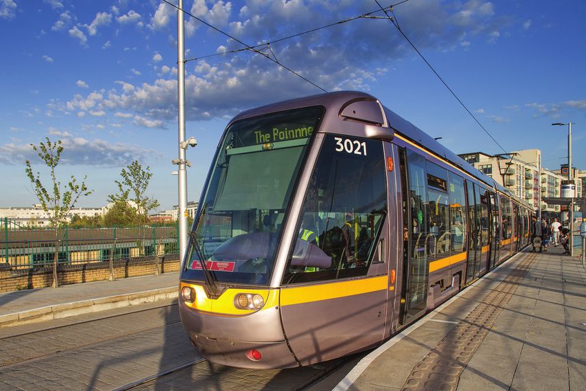
A target mode share of 15% for walking and 10% for cycling has been set by the
Council increasing the mode share from 13% and 5% respectively.
20%
5% 15%
10%
50% Walking Current 13% Target 15%
SDCC Target Mode Share
5%
Table 7.0 Existing and Target Mode Share (percentage)
Cycling Current Target 10%
SDCC Existing SDCC Target
Mode Mode Share Mode Share
(%) (%) 7.5.1 Sustainable Movement Studies
Walk 13 15 Sustainable Movements Studies were undertaken for each of the seven
Cycle 5 10 Neighbourhood Areas with the support of the NTA. The purpose of the studies was
to:
Bus 17 20
Train 3 5 àà Paint a picture of movement issues within each area; and
àà Identify measures to increase active transport modes (walking and cycling) and
Private (Car, Van, HGV, Motorcycle) 62 50 public transport to help achieve their target mode share and reduce dependency
on the car.
7.5 Walking and Cycling The outcomes of these studies have informed the policies and objectives on
sustainable movement within this chapter of the Development Plan. Summaries of the
To make active travel a credible alternative choice to car-based transport, and to
issues identified within each Neighbourhood Area are set out in Chapter 12 Our
Sustainable Movement (SM)
Sustainable Movement (SM)
facilitate the 10-minute neighbourhood, certain critical factors need to be in place:
Neighbourhoods.
àà A permeable pedestrian and cycling network that allows for multiple direct
Travel data for the County indicates that one quarter of trips under 3km and half of
connections between key destinations such as residential areas, shops, schools,
trips under 6km are car-based. Many of these short trips could be done by walking or
employment centres and public transport links; and
cycling.
àà An attractive and safe pedestrian and cycling environment where high quality
facilities are provided supporting their use by all ages and abilities.
ed
as
1/4
b
To achieve these objectives, the Council is actively engaged in initiatives which will
car
have a direct positive impact on walking and cycling: of trips
under 3km
àà Cycle South Dublin – This is a programme of works to provide a safe cycle 1/2
network within the County over the next decade; of trips
under 6km
àà Sustainable Movement Studies – These studies, carried out as part of the
preparation of the Development Plan, involved close examination of movement
within neighbourhoods with a view to identifying projects that will encourage
The Studies identify various measures to trigger a shift towards active travel and
active travel and the use of public transport;
public transport including:
àà Greenway projects including the extension of the Grand Canal Greenway and the
àà Improvements to public transport waiting facilities;
continuing rollout of the Dodder Greenway.
àà Traffic calming measures;
246 DRAFT SOUTH DUBLIN COUNTY DEVLOPMNT PLAN 2022-2028 DRAFT SOUTH DUBLIN COUNTY DEVLOPMNT PLAN 2022-2028 247àà Footpath widening and surface enhancement; Table 7.1 Cycle South Dublin Routes and Projects
àà Creating more permeable connections for walking and cycling and access to
Cycle South Dublin Routes and Projects
public transport routes;
(Cycle South Dublin routes are indicated on Development Plan Maps)
àà Improvements to cycle lane and cycle parking provision.
‘Now’ Schemes ‘Soon’ Schemes ‘Later’ Schemes
The studies have identified a number of potential projects within the County which
Route Route Route
will be set out in a Sustainable Movement Report for the County which will Route/Project Route/Project Route/Project
No. No. No.
accompany the Plan. Funding is available from the NTA for these types of project,
and this will be investigated as a resource to facilitate the achievement of the 1 Lucan Canal Loop 3 Corkagh Park to 20 Newcastle to
recommended improvements. Grand Canal Rathcoole
(A) Clondalkin Village to
Over time the implementation of these measures will result in more people walking, Grand Canal
(B) Corkagh Park
cycling and using public transport and less people using the private car. This will
result in many widespread and transformative benefits including: 2 Grand Canal 4 Tallaght to 21 Fortunestown Lane
extension Clondalkin Village (A) Citywest Avenue to
junction with Citywest
Road
(B) Ardmore Drive to
its junction with
Cookstown Road
A more active An increase A reduction in A reduction in Improved air
and healthy in road greenhouse gas traffic quality 5 N81 5 N81 22 Citywest Road
population safety emmissions and congestion (B) Jobstown Junction (A) Jobstown Junction - Citywest Avenue
consequent to N82 junction
positive climate to N81
impact
6 Tallaght Village to 7 Greenhills Road to 23 Tymon to Greenhills
Dodder Valley Dodder Valley Park
7.5.2 Cycle South Dublin From the Greenhills
Road to Kippure
Cycle South Dublin is a Council programme of works that aims to provide a well- Avenue, St Finbars
connected, well designed, and safe walking and cycling network that offers people of Close, St James Road
Sustainable Movement (SM)
Sustainable Movement (SM)
to Greenhills Park
all ages and abilities an attractive and credible alternative to using the car. It
proposes a set of projects that would deliver nearly 260km of new and improved
cycle lanes over the next ten years. Since 2016, traffic congestion in South Dublin 8 Dodder Greenway 14 Liffey Valley to Lucan 24 M50 Greenway
County has grown by 11% on main roads and this will become ever more challenging (A) Dodder Greenway Arc roundabout to (A) Clondalkin Grand
as the County’s population continues to grow over the coming years. The objectives bridges Lucan Canal to Ibis
of Cycle South Dublin are to: (B) to (F) Dodder Roundabout
Greenway Links (B) Red Cow round-
about to Kingswood
àà Provide a comprehensive and connected cycle network across South Dublin
(C) Kilnamanagh to
County; Tymon Lane
àà Increase participation and make cycling a more achievable mode of transport for (D) Balrothery, M50
people of all ages and abilities; and footbridge, Firhouse
àà Improve the cycling identity of the County. Weir, Junction of
Ballycullen Road and
The projects, which will be mainly funded by the NTA, will include improvements to Firhouse Road
the existing network and new ‘Now’, ‘Soon’ and ‘Later’ schemes to be progressed 9 Firhouse to 15 Clondalkin Boot 25 Rathcoole to
over the next 2, 5 and 8 years, respectively (see Table 7.1 below). A further separate Knocklyon Road to N4 Saggart
phase of works to facilitate cycling will be delivered by the NTA associated with the (A) Clondalkin Boot
BusConnects project. Road to Coldcut Road
248 DRAFT SOUTH DUBLIN COUNTY DEVLOPMNT PLAN 2022-2028 DRAFT SOUTH DUBLIN COUNTY DEVLOPMNT PLAN 2022-2028 2497.5.3 Design of Cycle Facilities
10 Wellington Road 16 Ninth Lock Road 32 Butterfield Avenue
11 Grange Road 17 Citywest Avenue, 33 Ballyroan Road The design of cycle facilities in Ireland is guided by the National Cycle Manual, NTA
Nutgrove Avenue to St City West Road to (2011) and any on-going revisions to this document. The cycle manual seeks to
Enda’s Drive R136 encourage cycling by promoting a safe environment for all road users with a specific
Citywest Avenue, N82 to focus on cyclists. It offers guidance on integrating the bike in the design of urban
Outer Ring Road areas through five basic principles:
12 Tallaght Streets 18 Bothar Katharine 34 Ballycullen Road
(A) Belgard North Link Tynan to Ballymount, àà Safety: Designers of transport infrastructure must seek to maximise road safety
Road Calmount Avenue for all road users, including cyclists.
(B) Airton Road àà Coherence: Cycling routes within the network should be logical and continuous.
Extension àà Directness: Cycling infrastructure should be as direct as possible, minimising any
(C) Public realm and
delays or detours.
Plaza
àà Attractiveness: The cycling environment along a route should be pleasant and
13 Celbridge Link 19 City West to 35 Cromwellsfort Road interesting. This is particularly important for beginners, tourists and recreational
Road Rathfarnham and Kimmage Road cyclists.
(A) N82 to N81 West àà Comfort: Cycling infrastructure should be designed, built and maintained for ease
(B) N81 to Whitestown of use and for comfort.
Way
(C) Killininny Road to its
The Planning Authority will generally apply the standards contained in the National
junction with Ballycullen
Road Cycle Manual when designing new cycle facilities (including tracks, lanes, paths and
(D) St Colmcille Way to storage facilities), and in the assessment of any new development proposals, subject
Ballyboden Road to certain constraints and environmental sensitivities.
(E) Ballyboden to
Rathfarnham The quantum of cycle parking required to service new developments is contained
within Chapter 13 Implementation and Monitoring, Bicycle Parking Standards.
15 N4 to Liffey Valley 26 Canal Loop to
Shopping Centre Celbridge Road
and Coldcut Road (A) Griffeen Valley Park 7.5.4 Active Travel and Schools
Sustainable Movement (SM)
Sustainable Movement (SM)
(B) N4 to Liffey Valley to Celbridge Link Road
SC and Coldcut Road (B) Celbridge Road to Travel data indicates that almost half of children walk to school where the school is
South Dublin County located within the same neighbourhood area. However, the analogous figure for
boundary cycling is very low at just over 4% while car journeys at almost 40% are excessively
21 Fortunestown Lane 27 Bancroft Park high for these short trips. With the provision of better cycle infrastructure and the
(C) Citywest Avenue (B) Bancroft Park prioritisation of active travel routes around schools, there is significant scope to
to junction with Garter greatly improve active modes, particularly cycling.
Lane (one side)
Several measures can be implemented to encourage a modal shift to walking and
27 Castletymon Road 28 Killinarden Park to
(A) Castletymon Road cycling for school journeys:
Oldbawn Road
(A) Killinarden Park to
Whitestown Way àà At planning and design stage, school sites should be chosen that are as close to
(B) Whitestown Way to the communities they serve as possible;
Oldbawn Road àà Permeability and connectivity with the surrounding area should be ensured by
provision of multiple pedestrian and cyclist access points to school sites;
29 Limekiln and 31 Kennelsfort Road
àà Mobility management plans should be required in order to establish measures to
Whitehall Road
reduce car-based travel and increase active travel modes and public transport
West
use;
30 Templeville Road àà Adequate and secure bicycle storage should be provided within school sites;
àà Positive interventions should be implemented such as participation in the Green
250 DRAFT SOUTH DUBLIN COUNTY DEVLOPMNT PLAN 2022-2028 DRAFT SOUTH DUBLIN COUNTY DEVLOPMNT PLAN 2022-2028 251Schools and School Streets projects (see below);
Policy SM2: Walking and Cycling
àà Priority should be given to provision of infrastructure including safe cycle ways,
footpaths and improved permeability schemes through the Cycle South Dublin Re-balance movement priorities towards sustainable modes of travel by
programme and other such initiatives. prioritising the development of walking and cycling facilities and encouraging a
shift to active travel for people of all ages and abilities, in line with the County
The Council will continue to work with local schools and the Department of targets.
Education and Skills at planning, design and operational stages in order to implement
SM2 Objective 1:
the measures set out above with the aim of ultimately leading to a significant modal
To achieve and monitor a transition to the County mode share targets of 15%
shift towards active travel to school.
Walk and 10% Cycle.
(Refer also to Section 8.10.2 in Chapter 8 Community Infrastructure and Public Open SM2 Objective 2:
Space). To create a comprehensive and legible County-wide network of safe cycling
and walking routes that link communities to key destinations, amenities and
School Streets Initiative leisure activities through implementation of the Cycle South Dublin project, the
The aim of the School Streets initiative is to restrict motorised traffic within an agreed recommendations of the Sustainable Movement Studies and other permeability
street, or zone, outside the school gate to create a safer environment in which measures.
children can feel encouraged to cycle, walk or scoot to school. South Dublin County SM2 Objective 3:
Council and the NTA are partners in the initiative. To ensure that connectivity for pedestrians and cyclists is maximised and
walking and cycling distances are reduced by promoting compact growth and
Objectives of the initiative include: permeability in the design and layout of new development areas.
àà Improved road safety and reduced traffic congestion by encouraging walking and SM2 Objective 4:
cycling; To ensure that connectivity for pedestrians and cyclists is maximised and
àà Improving the local environment and air quality by reducing dependence on walking and cycling distances are reduced in existing built-up areas, by
motorised vehicles; and removing barriers to movement and providing active travel facilities in order to
àà Promoting better health through more active travel. increase access to local shops, schools, public transport services and other
amenities, while also taking account of existing patterns of anti-social
The Council has identified eight schools across the County for a School Street pilot behaviour and other unintended consequences of removal of such barriers.
project which will be funded by the NTA.
Sustainable Movement (SM)
Sustainable Movement (SM)
SM2 Objective 5:
To ensure that all streets and street networks are designed in accordance with
The Council will take the lead in working with schools within the County to identify
the principles, approaches and standards contained in the Design Manual for
further suitable projects in order to achieve the objectives of the initiative.
Urban Roads and Streets so that the movement of pedestrians and cyclists is
prioritised within a safe and comfortable environment for a wide range of ages,
Green Schools Initiative abilities and journey types.
Green Schools is an environmental management and education programme for
schools, operated and coordinated by the Environmental Education Unit of An Taisce. SM2 Objective 6:
The aim is to promote long-term, whole-school action for the environment that is To ensure that facilities for pedestrians and cyclists are designed in accordance
student-led, with involvement from the wider community. There are several themes in with the principles, approaches and standards contained in the National Cycle
the programme including transport, which aims to increase the number of students Manual or any updated guidance and to promote off-road cycle infrastructure
walking, cycling, scooting, using public transport or carpooling to school. The where feasible, subject to any design having regard to environmental
transport theme is funded by the Department of Transport, Tourism and Sport and is sensitivities.
supported by the NTA. Many schools in the South Dublin County area participate in
the Green Schools initiative. The Council works closely with An Taisce, supported by
various government departments and sponsors, in the implementation of the Green
Schools Programme.
252 DRAFT SOUTH DUBLIN COUNTY DEVLOPMNT PLAN 2022-2028 DRAFT SOUTH DUBLIN COUNTY DEVLOPMNT PLAN 2022-2028 253SM2 Objective 7: SM2 Objective 13:
To promote walking and cycling for school trips by implementing the following To ensure that new walking and cycling routes are designed, insofar as
measures: possible, to function as links in the County’s green infrastructure network and
that adequate replacement and additional planting of native species and
àà Identifying school sites that are as close as possible to the communities pollinators is provided, and that SuDS approaches are used to deal with surface
they serve; water run-off.
àà Ensuring that multiple access points are provided to school sites for
SM2 Objective 14:
pedestrians and cyclists;
To ensure that all walking and cycling routes have regard to environmental
àà Ensuring that adequate and secure bicycle storage is provided within
conditions and sensitivities including biodiversity, protected species and
schools;
designated sites and to incorporate appropriate avoidance and mitigation
àà Promoting initiatives such as the Green Schools and Schools Streets
measures as part of any environmental assessments.
projects;
àà Prioritising school routes for permeability projects and provision and SM2 Objective 15:
enhancement of pedestrian and cycle ways; and To investigate the feasibility and potential opportunities for a greenway linking
àà Supporting the use of a range of physical measures to provide improved Newcastle, Rathcoole, Hazelhatch and the Grand Canal.
safety for pedestrians and cyclists at and close to schools.
SM2 SLO 1:
To provide for a pedestrian bridge over the N7 at the Barney’s Lane junction to
SM2 Objective 8: improve access to the Saggart Luas terminus.
To work with the NTA to acquire funding and secure full implementation of the
SM2 SLO 2:
Cycle South Dublin programme and the Sustainable Movement Studies
To consider an off-road shared cycle and pedestrian path from Stocking Lane
recommendations.
to the Hellfire Club to provide a safe alternative to cars, to access this amenity.
SM2 Objective 9:
SM2 SLO 3:
To work with the NTA to review the feasibility of implementing additional
On land border at Castleview site (formerly known as Coolamber), to maintain
cycling facilities within the major urban and recreational areas of the County.
a complete unbroken natural boundary comprising railings or other permanent
SM2 Objective 10: structure along the perimeter of the site (with the exception of an entrance off
To further develop a footpath and cycle path repair and assessment system the Newcastle Road and pedestrian and cyclist permeability with the
where members of the public can report maintenance issues and instigate Finnstown Neighbourhood Centre to the north of the site). The above
Sustainable Movement (SM)
Sustainable Movement (SM)
repairs, and to implement a public lighting renewal, improvement and notwithstanding any other related policies or objectives outlined in this Plan.
maintenance strategy in urban areas that provides adequate public lighting and
puts the safety of pedestrians, cyclists, women and minority groups at the
heart of this strategy, and to ensure that cycle paths are consistently and 7.6 Public Transport
properly maintained to a high standard to ensure that cyclists use them.
Approximately one fifth (20%) of trips originating in South Dublin County are by
SM2 Objective 11: public transport. This figure is quite low considering the built-up character of much of
To provide additional directional signs for major destinations, civic amenities the County, its proximity to Dublin City and the public transport services available in
and tourist attractions on major pedestrian and cycle routes, including the developed parts of the County.
references to distances, estimated times and/or number of steps to be taken.
SM2 Objective 12: To encourage a significant shift to public transport, the Council will continue to work
To support the implementation of the Council’s adopted County-wide signage with the NTA, the statutory authority responsible for long-term strategic transport
strategy (2020) that accords with the National Traffic Signs Manual and the planning in the Greater Dublin Area, to focus on the delivery of:
Failte Ireland ‘Dublin Visitor Orientation Strategy’ (2020) and takes into
account the local heritage and history of an area, particularly in a village àà Orbital public transport services linking major centres and areas of employment
context. such as Tallaght, Clondalkin and Liffey Valley and further linking to other parts of
the Greater Dublin Area;
àà Additional and extended public transport routes to service newly developed and
developing areas, and existing areas where gaps in services exist;
àà Transport hubs, to connect services (such as between orbital and radial routes
254 DRAFT SOUTH DUBLIN COUNTY DEVLOPMNT PLAN 2022-2028 DRAFT SOUTH DUBLIN COUNTY DEVLOPMNT PLAN 2022-2028 255and/or core and feeder routes) and form a ‘web’ like network;
Policy SM3: Public Transport – General
àà Improved access to public transport stops and services;
àà Improved integration between higher density forms of development and public Promote a significant shift from car-based travel to public transport in line with
transport nodes. County targets and facilitate the sustainable development of the County by
supporting and guiding national agencies in delivering major improvements to
The Council’s target is to increase public transport use for trips originating within the public transport network.
South Dublin County from the current low base of 17% bus and 3% rail, to 20% bus
SM3 Objective 1:
and 5% rail, respectively, over the lifetime of this Development Plan. This target also
To achieve and monitor a transition to the County mode share targets of 20%
sees private motorised travel (mainly car-based) reduce from the current high level of
Bus and 5% Rail.
62% to 50%.
SM3 Objective 2:
To facilitate and secure the implementation of major public transport projects
as identified within the NTA Transport Strategy for the Greater Dublin Area
3% 5%
(2016-2035), or any superseding document, including BusConnects, the DART
Rail Current Target
expansion programme along the Kildare route, the opening of the new rail
station at Kishogue and the Luas to Lucan.
SM3 Objective 3:
To ensure that future development is planned in such a manner as to facilitate a
significant shift to public transport use through pursuing compact growth
policies, consolidating development around existing and planned public
Bus Current 17% Target 20%
transport routes and interchanges, and maximising access to existing and
planned public transport services throughout the network.
SM3 Objective 4:
To optimise accessibility to public transport, increase catchment and maximise
permeability through the creation of new and upgrading of existing walking
and cycling routes linking to public transport stops.
SM3 Objective 5:
Sustainable Movement (SM)
Sustainable Movement (SM)
Current = 62% Target = 50% To facilitate an interlinked network that maximises the efficiency of existing
services, reduces overall journey times and facilitates easy exchanges between
modes and routes.
SM3 Objective 6:
To establish future public transport routes that will support the County’s
medium to long term development, including orbital routes to provide
There are a number of strategic projects in the GDA Strategy 2016-2035 proposed for connectivity between outer suburban areas.
South Dublin County that have the potential over the coming years to have a
transformative impact on travel by shifting the dominance of car-based transport SM3 Objective 7:
towards public transport. These include: To support and encourage the NTA in investigating high-capacity public
transport solutions for Dublin south-west, including examining the feasibility of
àà BusConnects Metro and/or Luas, serving areas including Ballyboden, Ballycullen/Oldcourt,
àà DART+ along the Kildare Line from Heuston to Hazelhatch Firhouse, Kimmage, Knocklyon, Rathfarnham, South Tallaght, Templeogue and
àà Luas to Lucan Terenure.
àà Transport interchanges at Tallaght and Liffey Valley.
SM3 Objective 8:
To support and collaborate with the NTA and Dublin City Council in carrying
The GDA Strategy is under review and the feasibility of a further light rail to the out an Area Based Study on future transportation for the Naas Road/
south-west of the County is being examined as part of this work. If proven to be Ballymount strategic regeneration lands.
feasible and included in the GDA Transport Strategy, the Council would support the
improved public transport benefits it would bring.
256 DRAFT SOUTH DUBLIN COUNTY DEVLOPMNT PLAN 2022-2028 DRAFT SOUTH DUBLIN COUNTY DEVLOPMNT PLAN 2022-2028 257Table 7.3 BusConnects Proposed Orbital Routes Serving South Dublin County
SM3 Objective 9:
To ensure that all new public transport corridors are designed to enhance the Route Number Destinations
County’s green infrastructure network by ensuring adequate replacement and
S4 Liffey Valley – Ballyfermot – Crumlin – Milltown – UCD
additional planting of native species and pollinators and to ensure that SuDS
approaches are used to deal with surface water run-off. S6 Tallaght – Dundrum – UCD – Blackrock
SM3 Objective 10: S8 Tallaght – Sandyford – Dun Laoghaire
To work with the relevant transport agencies to ensure that all public transport
W2 Liffey Valley – Clondalkin – Tallaght
proposals have regard to pertaining environmental conditions and sensitivities
including biodiversity, protected species and designated sites and incorporate W4 Tallaght – Grange Castle – Liffey Valley – Blanchardstown
appropriate avoidance and mitigation measures as part of any environmental
W6 Maynooth – Celbridge – Citywest – Tallaght
assessments.
Policy SM3: Public Transport – Bus
7.6.1 BusConnects
SM3 Objective 11:
BusConnects is the NTA programme for improvement of bus services in Dublin and To facilitate the delivery of the BusConnects Core Bus Corridors and seek
other cities across Ireland and is a key part of Government policy to improve public additional bus corridor and orbital routes to serve the County by securing and
transport and address climate change. The key elements of the strategy as it applies maintaining any required route reservations and to ensure the BusConnects
to Dublin are: Corridors do not adversely affect the village life and livelihoods of any of our
County Villages.
àà A network of continuous bus priority and safe cycling facilities along 16 corridors;
SM3 Objective 12:
àà A redesigned more efficient bus network with high frequency spines, new orbital
To work with the NTA to secure the expansion of the bus network to serve new
routes and increased bus services;
development and regeneration areas within the South Dublin County area
àà More user-friendly and convenient ticketing and payment systems;
including Tallaght, Naas Road, Adamstown, Clonburris, Fortunestown,
àà Improved bus waiting facilities;
Ballycullen and Newcastle.
àà A transition to a low emissions bus fleet.
SM3 Objective 13:
It is anticipated that a planning application for the radial core bus corridor To support new Bus Rapid Transit (BRT) lines as a means of providing new
Sustainable Movement (SM)
Sustainable Movement (SM)
infrastructure will be submitted by the NTA to An Bord Pleanála in late 2021. public transport links, where rail options are demonstrated by the NTA not to
Construction is expected to take place between 2022 and 2027. be achievable over the period of the County Development Plan 2022-2028,
including for the planned Metro (Metrowest) and along the Outer Ring Road
Table 7.2 BusConnects Proposed Radial Core Bus Corridor Routes Serving South Dublin and Adamstown-Citywest corridors.
County
SM3 Objective 14:
Route Number Origin/Destination
To support a review of bus services in the Naas Road environs including
Route 6 Lucan to City Centre investment in orbital services with a view to meeting future demand and
enhancing development potential of the Naas Road regeneration area.
Route 7 Liffey Valley to City Centre
Route 8 Clondalkin to Drimnagh SM3 Objective 15:
To support the enhancement of the Local Link Rural Transport Programme in
Route 9 Greenhills to City Centre order to provide the rural communities of the County with access to improved
Route 10 Tallaght to Terenure bus services.
Route 11 Kimmage to City Centre SM3 Objective 16:
To support a review of bus corridors in the N4 environs to expand into the
Route 12 Rathfarnham to City Centre
commuter belt towns of bordering County Kildare with a view to meeting
future demand of the surrounding Lucan and Adamstown area.
A number of orbital routes are also proposed which will greatly improve ease of
movement within the County and to destinations beyond. These are set out in Table
7.3.
258 DRAFT SOUTH DUBLIN COUNTY DEVLOPMNT PLAN 2022-2028 DRAFT SOUTH DUBLIN COUNTY DEVLOPMNT PLAN 2022-2028 259capacity on these existing lines to provide an increased service in line with need.
SM3 Objective 17:
To work with the NTA and other state agencies to facilitate the delivery of the
Luas to Lucan
Kennelsfort Road-R148 grade separated junction or an equivalent solution to
The NTA strategy provides for the extension of the Luas to Lucan, which will deliver a
maximise the efficacy of the BusConnects Project.
high-capacity radial service from this area to the City Centre, sufficient to cater for
SM3 Objective 18: the high transport demand along this corridor. The Luas will extend, subject to a
To liaise with bus service providers where new bus stop infrastructure is preferred route, into the centre of Lucan’s large residential areas to the south of the
proposed in order to ensure facilities such as shelters and bins are included, N4 and will connect to the city centre serving Lucan Village, Liffey Valley and
where appropriate. Ballyfermot along its route.
Metro/Luas to Dublin South West
The Council will continue to engage with the NTA, in the context of the review of the
GDA Transport Strategy, regarding public transport options for Dublin south-west
including the feasibility of Metro and/or Luas to serve the area.
7.6.3 Transport Interchanges
Multi-modal transport interchanges increase the efficiency and flow of public
transport services. A public square and transport interchange is proposed for Tallaght
Town Centre, that would provide a first-class interchange between the Luas,
BusConnects, taxi, cycling and walking.
In the 6-year period to 2026, the Tallaght Local Area Plan (LAP) provides for between
3,500-5,000 new housing units, the potential for significant additional non-residential
floorspace through more intensive employment, commercial and industrial use, new
schools and public services. Key to the realisation of the short-term development
potential of these lands are the implementation of the Transport Interchange which
will be located adjacent to the Tallaght Luas Stop, along with BusConnects, enhanced
Sustainable Movement (SM)
Sustainable Movement (SM)
orbital and local bus services and improved pedestrian and walking networks,
including permeability measures within the LAP area and to neighbouring areas.
7.6.2 Rail A transport interchange is also being progressed at the Liffey Valley Shopping Centre
campus. Liffey Valley Shopping Centre is a Major Retail Centre and Level 2 Major
DART Expansion Programme Town Centre in the retail hierarchy of the RSES which is continuing to expand, and
The implementation of the DART expansion programme will provide DART+ services the interchange will serve an essential function in the wider bus network and the
as far as Hazelhatch on the Kildare Line, serving the developing Adamstown SDZ NTA’s BusConnects project.
lands, the Grange Castle Business Park, the established areas of Clondalkin and the
Strategic Development Zone (SDZ) lands at Clonburris where a community of 23,000 Park and Ride Facilities
population is planned. The newly-built station at Kishogue will open during Phase 1B Park and Ride provides the opportunity for modal transfer from the private car to the
of the Clonburris SDZ Planning Scheme (1,001 – 2,000 residential units). The public transport network, for trips where car use is necessitated at the point of origin.
expansion programme will also provide an increased train frequency at Park West in They should be located in areas where the road network has the capacity to absorb
the Naas Road area. the impact of car traffic and should not be located to encourage people who would
otherwise access public transport locally, to drive further to access a site, adding to
Existing Luas Lines congestion. A number of park and ride facilities are located in the County with further
The existing Luas lines to Tallaght and Saggart provide excellent access to a high- proposed. The Planning Authority will consult with the NTA and other stakeholders to
quality public transport link for people living in and working in South Dublin. As new secure their implementation, as appropriate. Park and Ride policy is a component of
development in South Dublin and in Dublin City continues over the coming years, the the GDA Strategy.
Council will work with the NTA to assess the need and opportunity to increase the
260 DRAFT SOUTH DUBLIN COUNTY DEVLOPMNT PLAN 2022-2028 DRAFT SOUTH DUBLIN COUNTY DEVLOPMNT PLAN 2022-2028 261Table 7.4 Park and Ride Proposals
SM3 Objective 24:
Park and Ride Proposals To support and facilitate the development of multi-modal transport
Locations Status interchanges at Tallaght Town Centre and Liffey Valley.
Adamstown Station Temporary facility operating with a permanent SM3 Objective 25:
(Dublin-Kildare Railway) facility to be completed as part of the To facilitate the provision of Park and Ride facilities in appropriate locations at
Adamstown District centre development (as transport nodes and along strategic transport corridors in accordance with the
identified within the Adamstown SDZ Planning NTA Strategy.
Scheme)
Kishogue Station Park and Ride will come on-stream with the 7.7 Road Network
(Dublin-Kildare Railway) opening of Kishogue Station
While investment in active travel and public transport infrastructure remains at the
Lucan Availability of site for the provision of park and
top of the hierarchy, there will continue to be a need to invest in new road and street
(N4 Bus Corridor) ride to be investigated including potential for
infrastructure. Improvements to the road network and some new roads will be
Park and Ride at location on N4 immediately
required in the County to manage transport more efficiently and to provide access to
adjacent exit 4A and subject to this location
newly developing areas where there is a need to unlock brownfield and other lands in
being acceptable to the NTA
line with the principles of compact growth. Efficient road infrastructure is also critical
to support the economic development of the County and in particular the movement
Policy SM3: Public Transport – Rail, Transport Interchange and Park and of goods.
Ride
It is also acknowledged that the creation of more road space to cater for traffic,
SM3 Objective 19:
particularly in existing areas, is expensive and may serve to attract more cars to the
To promote the delivery of the Luas to Lucan and facilitate the reservation of
network. Managing travel demand and freeing up road and street space will be one of
any identified or emerging route.
the key challenges that the Council will face during the lifetime of this Plan.
SM3 Objective 20:
To support additional capacity on the Luas Red Line, to service the The road network will require to be carefully managed and expanded to:
intensification of development in Tallaght and Fortunestown and the future
development of the Naas Road lands. àà Facilitate access to areas of economic activity to and from the National Road
Sustainable Movement (SM)
Sustainable Movement (SM)
network, especially on the periphery of urban areas;
SM3 Objective 21:
àà Effectively manage access to and from the National Road network to minimise
To support the opening of the Kishogue rail station to align with the delivery of
any impacts on the local road and street network;
homes within the Clonburris SDZ area, in accordance with SDZ Planning
àà Ensure the safe and efficient operation of the national road network;
Scheme phasing.
àà Provide access to new communities and development lands;
SM3 Objective 22: àà Make the most efficient use of existing road space;
To investigate the option of an inter-county rail service stopping at Kishogue àà Provide a safer street environment with reduced vehicle speeds, particularly in
station which would provide access to new employment space at Clonburris areas where pedestrians and cyclists are likely to be more active;
and give direct access to the Grange Castle Business Park. àà Manage car parking in an effective manner.
SM3 Objective 23:
To support the delivery, in the short to medium term, of measures to enhance 7.7.1 Strategic Road Network
the development potential of the Naas Road/Ballymount lands including:
The principal strategic road network in the County comprises the N4, N7 and N81
àà A new train station on the Kildare Line adjacent to Kylemore Road;
forming three key radial routes; and the M50, Newlands-Fonthill (R113) and Outer
àà A new Luas stop on the Red Line between the Kylemore and Red Cow
Ring Road (R136) forming three key orbital routes. Management of the national road
stops (as per the RSES and MASP); and network including the N4, N7, N81 and M50, which are among the busiest roads in the
àà Increased frequency of Luas Red Line trams.
country, is the responsibility of Transport Infrastructure Ireland (TII). The Council will
continue to work with the NTA and TII to protect the capacity of these important
strategic roads.
262 DRAFT SOUTH DUBLIN COUNTY DEVLOPMNT PLAN 2022-2028 DRAFT SOUTH DUBLIN COUNTY DEVLOPMNT PLAN 2022-2028 263To ensure ongoing competitiveness and the efficient movement of people and goods
SM4 Objective 8:
within the County, strategic road access requires to be direct, particularly between
To work with the relevant transport agencies to ensure that all road and street
areas of employment and the national road network. The Core Strategy identifies a
network proposals have regard to pertaining environmental conditions and
number of strategic development areas that will accommodate new communities.
sensitivities including biodiversity, protected species and designated sites and
While public transport access will be prioritised, access to these areas will also be
incorporate appropriate avoidance and mitigation measures as part of any
required as part of the future development of the strategic road and street network.
environmental assessments.
Policy SM4: Strategic Road Network SM4 Objective 9:
To ensure that all new roads and streets are designed to enhance insofar as
Improve and, where necessary, expand the County-wide strategic road network
feasible, the County’s green infrastructure network by ensuring adequate
to support economic development and provide access to new communities and
replacement and additional planting of native species and pollinators and to
new development areas.
ensure that SuDS approaches are used to deal with surface water run-off.
SM4 Objective 1:
SM4 Objective 10:
To work closely with transport agencies including the Department of Transport,
To support sustainable measures including car-pooling and car clubs which
the National Transport Authority and Transport Infrastructure Ireland to protect
promote access to cars rather than car ownership and which facilitate higher
capacity and deliver improvements and extensions of the strategic road
utilisation of vehicles rather than higher numbers of vehicles.
network, where necessary and in line with national, regional and local climate
action plans. SM4 Objective 11:
To incorporate, where feasible, wildlife crossings including bridges and
SM4 Objective 2:
underpasses into the designs for new road infrastructure and where possible,
To facilitate and secure the implementation of major road projects as identified
incorporation of such measures into the existing road network.
within the relevant strategies and plans for the Greater Dublin Area.
SM4 SLO 1:
SM4 Objective 3:
To ensure that development on these lands at Whitechurch/Edmondstown only
To increase competitiveness by ensuring the efficient movement of people and
occurs where it can be delivered in tandem with the necessary transport
goods between enterprise and employment areas and the national road
infrastructure, including provision for walking and cycling, to facilitate such
network.
development.
SM4 Objective 4:
SM4 SLO 2:
To ensure that developing areas have sufficient access to the County’s road
To include an underpass as a part of any traffic management consideration as a
Sustainable Movement (SM)
Sustainable Movement (SM)
network.
practical solution to traffic delays on the N4 at Palmerstown Village.
SM4 Objective 5:
To support the provision of junction upgrades, where necessary, at key 7.7.2 New Street and Road Proposals
locations on the strategic road network.
The strategic road network consists of national and regional routes that carry the
SM4 Objective 6:
bulk of traffic within and through the County. Some expansion of the strategic road
To support innovative demand management measures on the M50, given
network is required to provide access to developing areas and to support the
current and projected demand for orbital movement and planned future
economic development of the County. This network expansion will also support the
population and employment growth in the County.
provision of accompanying infrastructure that supports more sustainable modes (e.g.
SM4 Objective 7: bus lanes and priority, cycle lanes, footpaths and crossing points).
To implement the 6-year Roads Programme set out under Tables 7.5 and 7.6
and to work towards the implementation of the medium-longer roads Through traffic primarily occurs along the M50 Motorway, two National Roads (N4
programme where feasible and subject to funding. and N7) and one National Secondary Road (N81). The management of these roads is
the responsibility of TII. The Council will continue to work with TII to support major
improvements to the national road network and to maintain and protect the safety,
capacity and efficiency of national roads and associated junctions in accordance with
the Spatial Planning and National Roads: Guidelines for Planning Authorities, DECLG
(2012).
264 DRAFT SOUTH DUBLIN COUNTY DEVLOPMNT PLAN 2022-2028 DRAFT SOUTH DUBLIN COUNTY DEVLOPMNT PLAN 2022-2028 265You can also read