Swarm-technology for Large-area Photogrammetry Survey and Spatially Complex 3D Modelling - TARGET h2020
←
→
Page content transcription
If your browser does not render page correctly, please read the page content below
International Journal of Latest Research in Engineering and Technology (IJLRET)
ISSN: 2454-5031
www.ijlret.com || Volume 04 - Issue 09 || September 2018 || PP. 33-39
Swarm-technology for Large-area Photogrammetry Survey and
Spatially Complex 3D Modelling
Lukas Auer1, Andreas Feichtner1, Friedrich Steinhäusler1
Robert Delleske2, Markus Keuschnig2
1
(International Security Competence Centre GmbH (ISCC), Austria)
2
(Georesearch For schungsgesellschaft mbH, Austria)
Abstract : Swarm technology represents a breakthrough in the creation of 3D models using drone-based
photogrammetry. The traditional single-drone approach for modelling of large areas(area >5 km²) or spatially
complex objects (e.g., buildings, infrastructures) requires long flight times and is frequently associated with
variable light- and meteorological conditions during periods spanning several days. This is especially true for
drone copters. In this EU-supported project (www.target-h2020.eu) COTSdrones have been evaluated and the
drone DJI Mavic Pro (MP) has been selected for optimal performance. Based on MP, the Photogrammetry
Swarm Kit (PSK) has been developed, offering considerable time- and cost savings as compared to the
traditional single drone approach.PSK is comprised of five MP drones housed in a specially designed, portable
container, together with control unit and power supplyand aground control station.PSK uses WiFi
communication and is adjusted to a Digital Elevation Model to ensure a precise flight. It offers three modes of
data acquisition (Area Mode, Highlight Mode, Angle Mode). PSK has been field-tested in the European Union
and the Republic of Kyrgyzstan and received the DRONE HERO EUROPE Award 2018.
Keyword: Drone, Swarm, Photogrammetry, 3D Modelling.
1. INTRODUCTION
Drone Swarming is a relatively new field of robotics research. Swarm technology enables drones to
perform as an intelligent group, interpreting what is happening in real-time and self-organize. Using appropriate
software, drones can ascend synchronously, communicate with each other and create cross-references. Drones
flying in cooperation can create networks and transfer information. They can be used as mobile radio stations or
WLAN transmitters in regions lacking infrastructure.
In the recent past the spectrum of swarm applications in very different fields has been growing fast, for
example:
Ehang created a swarm of a thousand drones with the ability to improvise and troubleshoot errors
autonomously [1];
University of Cambridge andKoc University unveiled the concept of Energy Neutral Internet of Drones. [2]
Such a drone swarm shares information or energy with other drones that did not receive a communication
or are running low on energy;
US Department of Defense tested successfully a swarm of miniature drones with advanced swarm
behaviour, such as collective decision-making, adaptive formation flying, and self-healing [3];
NASA plans on deploying swarms of tiny spacecraft for space exploration [4];
Medical community is looking into using swarms of nanobots for precision delivery of drugs,
microsurgery, targeting toxins, and biological sensors [5].
Currently, about 30 nations are actively developing drone swarms—and even submersible drones—for
military missions, including intelligence gathering, missile defence, precision missile strikes, and enhanced
communication[6].
In the topic area high spatial resolution drone-based photogrammetry initial field applications were
reported in 2016. [7, 8, 9] This method produced geo-referenced 3D point clouds from hundreds
to thousands of digital images, which in turn resulted in orthoimages covering areas up to 15 km² with a spatial
resolution < 1cm/pixel.
The European Commission tasked the International Security Competence Centre GmbH (ISCC),
Austria) within the framework of the EU H2020 project TARGET (http://www.target-h2020.eu/)to develop a
drone-based methodology for the creation of 3D models of large areas using photogrammetry. This paper
describes the developmentof an end-user friendly, drone-swarm technology, capable of modelling up to several
hundred hectares within a reasonable time period, created in cooperation between ISCC GmbH and Georesearch
For schungsgesellschaft mbH.
www.ijlret.com 33 | Page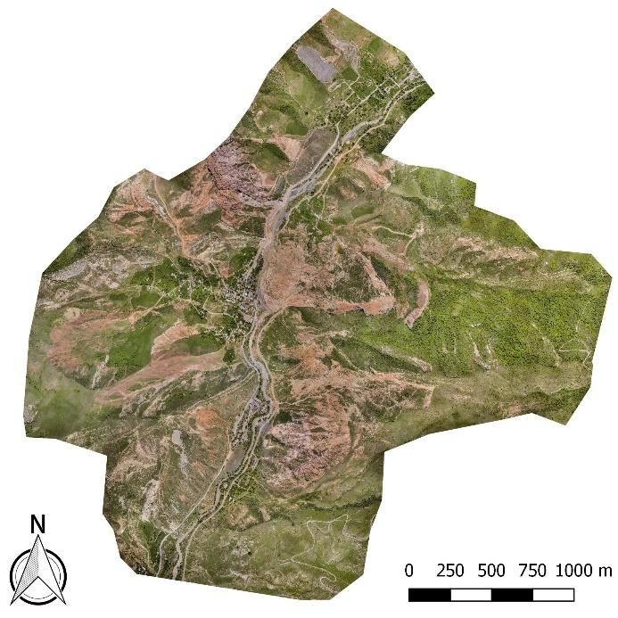
International Journal of Latest Research in Engineering and Technology (IJLRET)
ISSN: 2454-5031
www.ijlret.com || Volume 04 - Issue 09 || September 2018 || PP. 33-39
2. SWARM BASED PHOTOGRAMMETRY
Creating high resolution 3D models covering areas as large as a few km² requires typically hundreds of
conventional drone flight operations in the target area lasting several days. In this project a photogrammetry-
capable swarm drone technology was developed with commercial-off-the-shelve (COTS), low-cost, mass
produced, unmanned aerial vehicles (UAV). Multiple such UAVs,forming a swarm, provide the large number of
photos needed for 3D modelling (typically several thousands of digital images) within typically one day of
operation. This approach has three mutually supportive advantages:
COTS: This feature ensures world-wide availability of UAVs and spare parts, good integration in software
products,and excellent cost/benefit ratio;
Shorter Operational Time: Drone swarming can cover the area to be modelled in a significantly shorter
time than a single drone; the actual time saving is directly proportional to the number of drones deployed
in the swarm. The number ofCOTS drones in this project was limited to five;
Less Variable Boundary Conditions: Due to the shorter period of deploying a drone swarm (typical swarm
UAV mission duration: one day) meteorological conditions and light conditions are more likely to remain
unchanged as compared to a single drone-based photogrammetry mission lasting several days.
2.1 Drone
Based on the results of an international drone-market survey, ISCC selected the DJI Mavic Pro (MP) as
the basis for the drone swarm (https://www.dji.com/de/mavic). System reliability is key in a complex
photogrammetry field mission: MP has 24 high-performance computing cores, a transmission system with a
7km range, five vision sensors, and a 4K camera stabilized by a 3-axis mechanical gimbal. Another advantage
of MP with regard to swarm-transport and field work is its size: the volume of an MP is comparable to a 1 liter-
bottle. The drone has the following aircraft specifications:
Diagonal size (propellers excluded): 335 mm
Weight (battery, propellers, gimbal cover included): 743 g
Maximum speed: 65 km/h
Maximum flight time (no wind): 27 min
Maximum service ceiling above Sea Level: 5 000 m
Operating temperature: 0° to 40°C
Satellite positioning systems: GLONASS (Russia) and GPS (USA)
Hovering accuracy: vertical - +/- 0.1 m; horizontal - +/- 0.3 m
Consumer drones deploy three types of ―sense and avoid‖ technology, enabling them to fly also
indoors to a limited extent: (1) Sonar – Sound waves bouncing off a nearby surface. Sonar can detect large
objects (like the ground) at a distance up to 6 m; (2) Infrared – Infrared sensors limited to toy drone mode
(various technical shortcomings); (3) Camera - Downward facing low-resolution camera, capable of pattern
recognition (e.g., floor tiles). MP uses a deep neural network approach with high resolution cameras on the
drone body. These cameras feed information into a specialized processor,which provides computer vision. The
cameras, along with two ultrasonic sonar sensors, assist with indoor flight and ground sensing, as well as
increase drone stability.
Three intelligent flight modes are incorporated in the MP drone system: (1) Obstacle Avoidance: In
combination with the front sensors the drone can determine how to clear objects, such as vehicles, etc.; (2)
Active Track: Forward cameras recognize and track objects, such as persons, etc.; it allows MP to position itself
around the subject in various ways; (3) TapFly: Allowing for ―point and fly‖ on the screen control, this mode
includes avoidance and/or recognition of objects.
2.2 Camera
The main objective of a photogrammetry mission is the provision of sharp, high-contrast photos from
all angles together with their orientation data, which can be post-processed to create a photorealistic 3D model
without any gaps. MP can take photos in RAW format (*.dng), enabling the user to post-process photos without
any loss of information. For example, modelling a glacier the low contrast of the snow cover requires
optimization of several parameters prior to photogrammetry-based modelling (whitebalance, exposure, contrast,
highlights, shadows, whites, blacks). Furthermore, MP stores automatically GPS-data, as well as spatial
orientation of each photo as EXIF data. This facilitates quality control on site and accelerates processing of the
data during 3D modelling.
Drone camera quality is essential for the quality of the 3D model and needs to equal the quality of a
mirror-less camera. The quality of a video/photo depends on the camera sensor size and type, the lens and on the
www.ijlret.com 34 | Page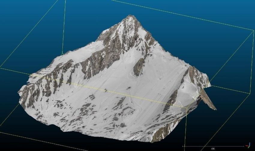
International Journal of Latest Research in Engineering and Technology (IJLRET)
ISSN: 2454-5031
www.ijlret.com || Volume 04 - Issue 09 || September 2018 || PP. 33-39
ability speed(bit-rate) that the camera sensor can send those images into memory (SD card). The larger the
sensor and the faster the rate, the better the potential quality of the final image and/or video. Whilst most
consumer-level camera drones use bit-rates of 20-50 Mbps, the MP bit-rate is 60 Mbps. MP has a still-photo
resolution of 12 Megapixel, comparable to the upper range of consumer-level cameras. It uses a sensor (SONY
1/2.3‖) and a bright lens (f/2.2), which allows more light to impact on the sensor, resulting in a higher (sharper)
image quality. Focus of the MP 28 mm lens is adjustable and automatic, as opposed to the fixed focus on most
consumer-grade digital cameras. A maximum exposure of 8 seconds is possible due to the 3-axis gimbal
stabilization. A headset displays an 85° view from the drone with two 1920 x 1080 display screens, up to 1080p
image transmission and low latency wireless connection.

2.3 Photogrammetry Swarm Kit
         ISCC has developed, in cooperation with Georesearch For schungsgesellschaftmbH, the
Photogrammetry Swarm Kit (PSK). PSK is comprised of five MP drones (Note: PSK can be adapted to include
a larger number of drones), housed in a specially designed, portable container, together with control unit and
power supply for a smart and fast swarm data generating process(Fig. 1). Field missions require a compact
carrying case, preferably in compliance with international Civil Aviation Regulations for luggage. Meeting these
requirements, a ruggedized container was designed for up to five MP drones, five radio control units, five
smartphones, a WiFi Hotspot and a notebook as ground control station.The plastic housing is water-, dust- and
drop-resistant to withstand rough transport in the field under extreme weather conditions.

2.4 Flight Programming
          The PSK uses WiFi communication and is adjusted to a Digital Elevation Model (DEM) to ensure a
precise flight, even at high altitude and other challenging environments.
The PSK offers three modes of data acquisition:
• Area Mode: Five drones are used simultaneously to record large areas within short periods of time. Each
    drone is assigned a defined sub-area within the Area-of-Interest (AOI).
    Application: 3D modelling of a large area;
• Highlight Mode: Same operating principle as Area Mode. Relevant sub-areas (highlights) of the AOI are
    recorded at higher resolutions (e.g. for detailed planning in modelling large projects).
    Application: 3D overview model, plus 3D models of one or more pre-defined AOIs with enhanced
    resolution.

 Figure 1:Photogrammetry Swarm Transport Container: (1) Five UAVs-model DJI MP; (2) Ten spare batteries;
                    (3) Notebook computer; (4) Battery charger &spare parts; (5) Tape,
                                                   www.ijlret.com                                       35 | Page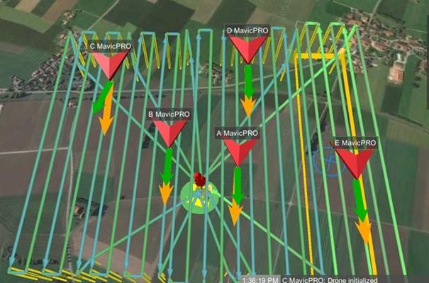
International Journal of Latest Research in Engineering and Technology (IJLRET)
ISSN: 2454-5031
www.ijlret.com || Volume 04 - Issue 09 || September 2018 || PP. 33-39
• Angle Mode: Five drones are used simultaneously to record spatially complex objects. Relevant spatial
orientations of the investigated object are captured by complementary acquisition angles.
Application: 3D modelling of a complex object.
In the current swarm drone configuration each drone communicates with the other four drones and the
ground station, whilst carrying out the photogrammetry mission. At present, a single operator can control an
entire swarm of up to five drones. Actual mission planning and execution is carried out under remote control by
the Mission Controller. Currently, this includes the pre-programming of the flight routes for the five drones
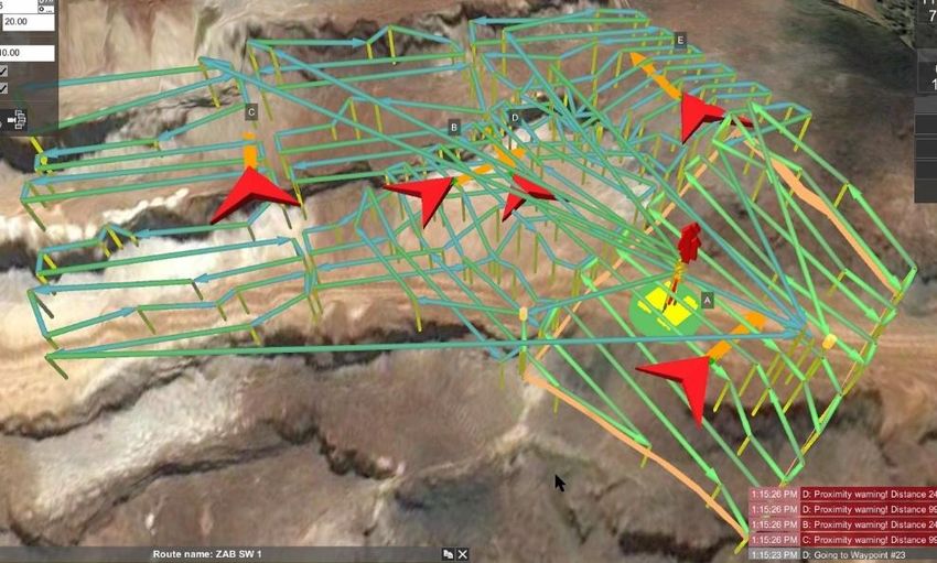
forming a swarm (MavicPRO, code A to E in Fig. 2).The complexity of flight mission planning reflects the
geographical features of the area to be modelled, e.g., waypoint programming for a 3D model of a surface mine
with complex surface structure is shown in Fig. 3.
Figure 2. Pre-programmed large area Way Point-flight routes for photogrammetry swarm consisting of five MP
drones (Code A to E).
Figure 3: PSH flight mission planning for high resolution (< 1 cm accuracy deformation measurement)3D
photogrammetry model of surface mine, ZAB-Erzberg (Austria).
2.5 Field Test and Results
The complete PSK underwent extensive field tests in Europe (Austria, Germany) and Central Asia
(Kyrgyzstan). Fig. 4 shows the MP swarm in action hovering over the landscape to be modelled; PSK Transport
Container located in forefront of the photo.In Fig. 5 the result of drone-based photorealistic 3D modelling of a
large area is shown. Fig. 6 shows the photorealistic 3D model of a large airport terminal.
www.ijlret.com 36 | Page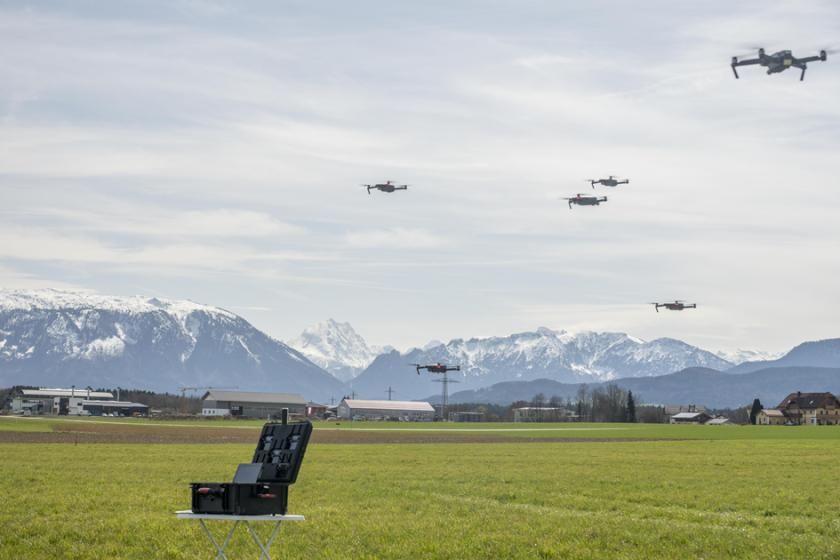
International Journal of Latest Research in Engineering and Technology (IJLRET)
ISSN: 2454-5031
www.ijlret.com || Volume 04 - Issue 09 || September 2018 || PP. 33-39

   Figure 4: Photogrammetry Swarm in action, with five MP drones in swarm formation hovering above the
              transport container during a test flight in 2018; a sixth drone is filming the swarm.

  Figure 5: Photorealistic 3D photogrammetry model of Austrian glacierKitzsteinhorn (altitude: 3 200m; area:
                            2.8km²) using PSK; total flight time for mission: 17 min.

          Figure 6: Photorealistic 3D photogrammetry model of airport terminal, Berlin (Germany).

                                                 www.ijlret.com                                     37 | Page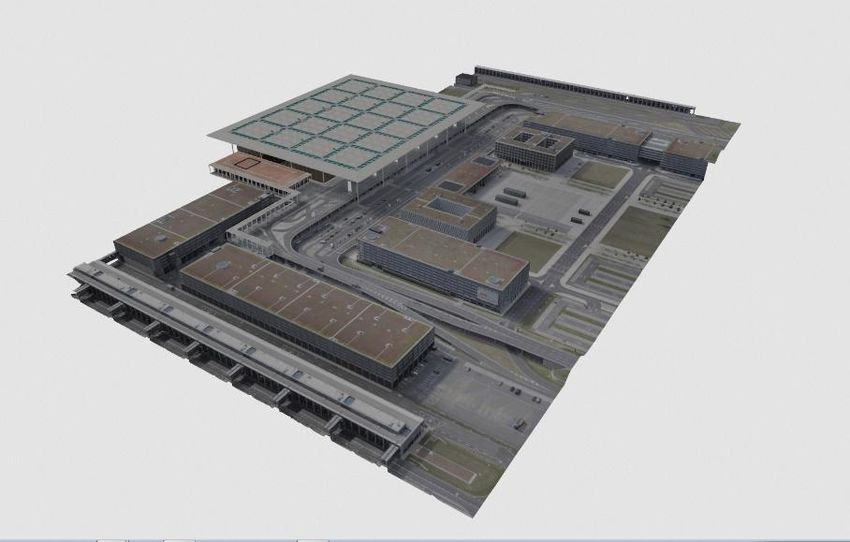
International Journal of Latest Research in Engineering and Technology (IJLRET)
ISSN: 2454-5031
www.ijlret.com || Volume 04 - Issue 09 || September 2018 || PP. 33-39
          The PSK has been used for modelling a large area(8 km²) in the Republic of Kyrgyzstan in 2018
(resolution 12.5cm/pixel). Five drones, following eleven individually programmed flight plans,covered a
distance of 80 km in 50 min (Fig. 7). This represents a time saving of about five hours as compared to the
deployment of a single drone. Fig. 8 shows the results of this mission, i.e., the Orthoimage (left) and Digital
Elevation Model as a Hillshade (right) of a radioactive contaminated area (8km²) in in the MailluuSuu Area.

             Figure 7: Swarm drones taking off in the radioactive contaminated MailluuSuu Area
                                         (Republic of Kyrgyzstan)

  Figure 8: Orthoimage (left) and Digital Elevation Modell as a Hillshade (Right) of radioactive contaminated
                                  area (8km²) in the Republic of Kyrgyzstan

                                            3. CONCLUSIONS
         The PSK system enables the end user to program and operate a swarm drone system, capable of
creating high-resolution 3D models of large areas. Due to the swarm-technology the modelling process requires
less time than with a single droneand is therefore more cost-effective. The PSK approach, using COTS
unmanned aerial vehicles, demonstrated successfully that:
     (a) Operational time can be shortened,
     (b) Image quality can be improved due to more stable lighting conditions during shorter flights,

                                                 www.ijlret.com                                      38 | Page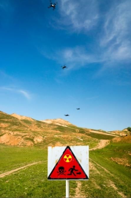
International Journal of Latest Research in Engineering and Technology (IJLRET)
ISSN: 2454-5031
www.ijlret.com || Volume 04 - Issue 09 || September 2018 || PP. 33-39
       (c) Purchasing costs for the whole system and operating costs can be reduced significantly by deploying
       COTS drones in a swarm formation instead of a specially designed, high-end, single drone.

          Field tests have demonstrated the functioning of the PSK swarm system by photorealistic modelling of
large areas and spatially complex 3D structures. The value of this innovative concept was acknowledged by the
international jury of the DRONE HERO EUROPE 2018 competition by awarding the first place in the category
Start Up(https://www.dronecommunity.biz/drone-hero-europe/winners-2018/) to ISCC and its partner
GEORESEARCH.

                                      4. ACKNOWLEDGEMENTS
        This project has received funding from the European Union’s Horizon 2020 research and innovation
programme under grant agreement No 653350; further details on the TARGET project at http://www.target-
h2020.eu/.

                                                 REFERENCES
[1].       EHang, 1000 Drone Light Show Refreshed World Record, EHANG Company News, 11 February
           2017, http://www.ehang.com/news/249.html; last visited 23 July 2018.
[2].       Teng Long et al., Energy Neutral Internet of Drones, IEEE Communications Mag., vol. 56, no. 1, pp.
           22 – 28, Jan. 2018, DOI: 10.1109/MCOM.2017.1700454.
[3].       U.S. Department of Defense, Department of Defense Announces Successful Micro-Drone
           Demonstration, Department of Defense Release No.: NR-008-17, 9 January 2017,
           https://www.defense.gov/News/News-Releases/News-Release-View/Article/1044811/department-of-
           defense-announces-successful-micro-drone-demonstration/;last visited 23 July 2018.
[4].       NASA, NASA Selects University Partners for Small Spacecraft Collaboration, 1 December 2017,
           https://www.nasa.gov/directorates/spacetech/small_spacecraft/feature/NASA_Selects_University_Part
           ners_for_Small_Spacecraft_Collaboration; last visited 23 July 2018..
[5].       Megan Scudellari, The Tiny Robots Will See You Now, IEEE Spectrum, 1 March 2017,
           https://spectrum.ieee.org/the-human-os/biomedical/devices/the-tiny-robots-will-see-you-now;    last
           visited 23 July 2018..
[6].       Andrew Ilachinski, AI, Robots, and Swarms, CAN Analysis & Solutions, January 2017,
           https://www.cna.org/CNA_files/PDF/DRM-2017-U-014796-Final.pdf; last visited 23 July 2018..
[7].       Alexander Cruden et al., High Spatial Resolution Mapping of Dykes Using Unmanned Aerial Vehicle
           (UAV) Photogrammetry: New Insights on Emplacement Processes. Acta GeologicaSinica, 90, pp. 52-
           53, 2016. DOI: 10.1111/1755-6724.12883.
[8].       Christopher Gomez and Heather Purdie, UAV- based Photogrammetry and Geocomputing for Hazards
           and Disaster Risk Monitoring – A Review, Geoenviron Disasters (2016) 3: 23.
           https://doi.org/10.1186/s40677-016-0060-y.
[9].       Abdul Nishara, Steve Richards, Dan Breena, John Robertson, BarbaraBreen, Thermal infrared imaging
           of geothermal environments and by an unmanned aerial vehicle (UAV): A case study of the Wairakei –
           Tauhara geothermal field, Taupo, New Zealand, Renewable Energy (2016): 86, pp. 1256-1264.

                                                  www.ijlret.com                                    39 | Page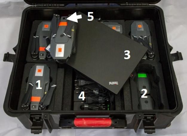
You can also read