The age of submerged forest off Haverigg Point, near Millom, and other SW Cumbrian sites
←
→
Page content transcription
If your browser does not render page correctly, please read the page content below
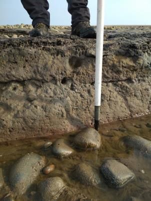
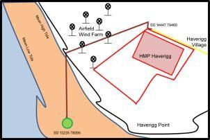
The age of submerged forest off Haverigg Point, near Millom, and
other SW Cumbrian sites

The remains of a prehistoric forest have been
rediscovered off Haverigg Point. It was first noted by
Helen Beaumont as she walked on the shore. She
remembered seeing it some thirty years previously
and not since. As the remains only appear at the
very lowest of low tides, it maybe that they have
been exposed in the intervening year but not been
noticed. Crossing the old airfield by HMP Haverigg
to the beach and turning 600 metres due south, you
came to what had been a black smudge as you
approached. This was a shelf 40m x 20m of dark
clay on grey clay. There were lengths of tree trunks,
branches and some stumps all over the place laid on
a hard black surface that looked like solid leaf mould
or peat.

Submerged (aka drowned “forests”) have been
reported at several locations along the Cumbrian
coast from Kirby-in-Furness north to the Solway
Firth. Over several decades people from Haverigg
and Millom have observed preserved tree trunks
during lowest tide intervals at a site between
Haverigg and Kirkstanton. The Duddon History
group is working with a former Millomite*,
Professor John T. Andrews, at the University of
Colorado at Boulder, to obtain the age of these trees
and to understand their significance under the
present-day conditions of melting ice sheets and sea-
level change. The current project builds on work
started nearly 40 years ago with then colleagues
from the University of Nottingham and Yale
University (USA) who dated wood from the
Ravenglass foreshore at 8634 ± 200 yrs Before
Present (BP) and showed that sea-level was close to
present by 5000 yr BP.

The relative sea-level that we observe at any point on the Earth’s surface reflects two major
factors: first is whether the Earth’s surface is rising or falling at that point, and the second is
change in the water balance driven mainly by whether ice sheets and glaciers are growing or
shrinking - at the present time global sea level is rising at ca 3 ± 0.4 mm/year due to climate
change .

Twenty-thousand years ago the British Ice Sheet filled the Irish Sea and reached an elevation of at
least 250m on the seaward slope of Black Combe above Gutterby. By 14,000 years ago the ice had
retreated from the Cumbrian coast with small glaciers existing in shady locations, such as on Black
Combe. The Earth’s crust responds to application of large loads, such as ice sheets, by sinking but
then rebounding as the ice sheets retreated and the load is thus removed.
At the glacial maximum global sea level was about 130 m lower than present due to the transfer of
water from the oceans into the large global ice sheets. As these ice sheets melted the water was
added back into the oceans causing sea level to rise. Along the Cumbrian coast what is called
“relative sea level” (what we see) is the product of i) changes in elevation of the land, and ii)
changes in global sea level.
At the present time satellite observations of a site at St Bees indicate virtually no rebound over the
last 12 yrs and this probably also applies to the Duddon Estuary region. As global sea level is
rising at ca 3 ± 0.4 mm/yr (due to the melting glaciers and ice caps) then a rise of sea level along
the Cumbrian coast appears inevitable.
(http://geodesy.unr.edu/NGLStationPages/stations/STBE.sta)
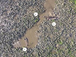
Our first visit recorded the site without any surveying equipment, using a 30cm yellow Garmin
GPS unit for scale in the photographs. Subsequently we have visited with a drone and tape to
record the site. The 2018 drone shots were disappointing because the site was still under water
even though it was the lowest tide of the month. The 2019 shots were clearer and used 10cm red
and white chevron tape for scale. The encroaching stones are even more apparent.
2018 2019
On each occasion there has been less of the forest visible and an increasing covering of stones. On
the last visit, there was nothing visible and it isn’t clear whether the remains have been washed
away for good or covered waiting to be revealed again in the future. Two samples were taken in
2018 for dating. It was remarkable how hard it was to saw through the wood.
We obtained our first radiocarbon date from the Haverigg site in April, 2019. The sample was
collected by Helen Beaumont. Two more were submitted in May and were collected by Stephe
Cove and Helen Beaumont. The initial radiocarbon age was 7700 ± 25 yr---this has to be corrected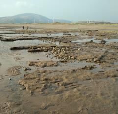
for measured changes in the 14C reservoir and this resulted in a “calibrated” age of 8482 ± 35 yr.
The samples were also sent to Dr. Hilke Schroeder at the Thuenen-Institute of Forest Genetics in
Germany and were identified as Salix - willow, and Quercus - oak (either English oak, Quercus
robur, or Cornish oak, petraea).This places the age estimate in the context of global sea level at
that time (-17 ± 0.5 m below present), the rate of change (and the present-day rate), the present
tidal range, and the elevation of the samples. Another sample, taken earlier from the Duddon
Estuary off Kirkby in Furness, has also been dated with a result of 8724 ± 30 yrs, so ~ the same
age ± as the trees from Haverigg and Ravenglass. The dating evidence indicates that ca 8500
years ago trees were growing at what is now 11 m or so below the high tide level. At that time the
global sea level was ~17 m below present, thus the coast during Mesolithic time would have been
seaward of the present-day low tide limit. The average combined age for all the samples is 8600 ±
and it may reflect a jump in sea level associated with the final collapse of the North American ice
sheet over Hudson Bay, Canada, thus perhaps an harbinger of things to come given the worries
about the West Antarctic Ice Sheet.
2018 2019
John Andrews was born in 7 Surrey St and lived (1937-1956) in 25 Oxford St. The family
owned a shop and yeast business at 1 Surrey St. He attended Millom Grammar School and
played for the England U-19 schools RU XV in 1955 and 1956. He has a BA, PhD and DSc
from the University of Nottingham and an MSc degree from McGill University. He is a
Professor Emeritus of Geological Sciences at the University of Colorado Boulder and has
worked in both the Arctic and Antarctica on ice sheet histories.
Miss Helen Beaumont is one of the Academic Support Staff who works with Reception
children at Captain Shaw’s School at Bootle.
Stephe Cove is a retired primary school teacher and committee member of the Duddon
Valley Local History Group
Dr Hilke Schneider is a scientist with the
Funds to purchase the radiocarbon dates were provided by a grant from the University of
Colorado’s Retired Faculty Association.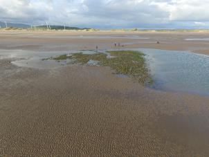
You can also read