THE ALPINE PATHS of the province of Belluno - Auronzo Misurina
←
→
Page content transcription
If your browser does not render page correctly, please read the page content below
ENGLISH

THE ALPINE
PATHS
of the province
of Belluno
INDEX

The Alta Vias of the Dolomites (Dolomite High Routes)
03.The Alta Via 1 04.The Alta Via 2 05.The Alta Via 3 06.The
Alta Via 4 07.The Alta Via 5 08.The Alta Via 6
09.The Alta Via 7 10.The Alta Via 8 11.The Alta Via 9 12. The
Alta Via dei Pastori (The High Route of the Shepherds)
13.The Alta Via dell'Orso (The High Route of the Bear) 14.The
Alta Via Amelia 15.The Traverse of Cadore
The cammini delle Dolomiti (The Walks of the Dolomites)
19.The cammino delle Dolomiti 20. The Via dei Papi (The
Way of the Popes) 21.Park2trek 22. The Dolomiti Bellunesi
Alta Via 23. The Yellow Via Alpina 24.he Dolomites in
miniature 25. The Via degli Ospizi (The Trail of the Hospices)
26.Sentiero Buzzati (The trail of Dino Buzzati) 27.Strada
de la Vena 28.E7 Venetian Prealps of Belluno and Treviso
29.Anello Zoldano 30.Piccolo Anello Zoldano (Small Zoldo
Circuit) 31.Munich—Venice 32.Cortina Dolomiti Ultra Trekking
33. Sentieri Parlanti (Talking Trails)

                               In the meantime, the first rays
                               of sunlight reach the high peaks.
                               Now Barnabo admires the mountains.
                               They don't really look like towers,
                               castles or ruined churches,
                               but these ones only look like themselves,
                               just as these ones are,
                               with the white landslides, the crevasses,
                               the gravel ledges, the endless edges
                               overhanging bent out into the void.

                               from Bàrnabo delle montagne
                               Dino Buzzati

                               Consorzio DMO Dolomiti
                               c/o Provincia di Belluno
                               Telefono
                               + 39 0437 959247
                               Mail
                               mail@infodolomiti.it

                               www.infodolomiti.it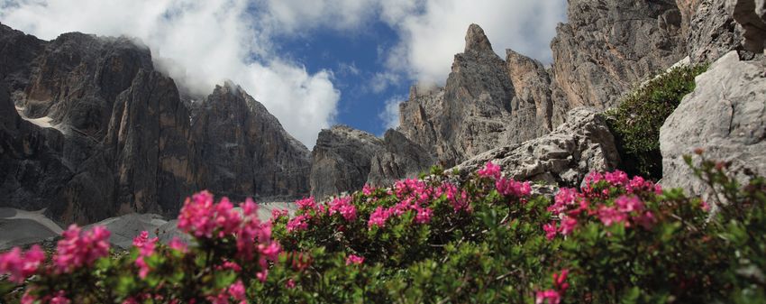
THE ALPINE PATH OF
THE DOLOMITES
THE ALPINE PATH OF
THE DOLOMITES 1
125 kilometres, 12 stages and 7300 metres of elevation
gain, the “Classic” is one of the most accessible Alta
Vias. From the intense blue of the Pragser Wildsee
(Bolzano) to Belluno, “the shining city”, the Alta Via
1 is a succession of incredible landscapes. The first
stages reach the mountain huts Biella and Fanes,
passing through a lunar landscape, desert in some
parts, where you can admire Cristallo and Croda
Rossa. From here, you reach the Lagazuoi hut, at 2572
metres, with the majestic vertical rock sides of the
Tofane that overlook the landscape, until conquering
then the amazing view from the Nuvolau hut. You
continue then towards Ra Gusela, the first easy via
ferrata (protected climbing route) of the trail, and
hike down to the Giau Pass. Further on, the huts Città
di Fiume, Venezia, Coldai and Tissi take you to the
magnificence of Pelmo and Civetta. Run along Torre
Venezia of the Civetta, you continue to the Vazzoler
hut and from here to the Carestiato hut, through cart
tracks and paths. Afterwards, you reach Moiazza and
Pramperet and the landscape completely changes:
you leave the rough rock sides to enter the wild
Dolomiti Bellunesi National Park. The last two stages
on the Schiara group are the hardest both from a
physical and a technical point of view: from the Pian
de Fontana hut to the VII Alpini hut, some via ferratas
and an important elevation gain are a challenge even
for the most experienced hikers, but also the most
                                                                          Starting Point Ending Point   Average        Distance
demanding trekkers will be satisfied in the end. For                      lago di Bràies Belluno        walking days   125 km
the less experienced, we recommend to take the                                                          media 12
variant to the Bianchet hut. From here, a comfortable
path leads you to Peron and the hamlets of Tisoi and
Bolzano Bellunese, reaching then the city centre of
Belluno. On the original path, the descent to Belluno
does not have specific difficulties. Near Case Bortot,
the Bus del Buson and the gorges of the Ardo creek
are evocative.

    The Dolomites, also called “Pale Mountains”, are located in the regions of Veneto,
    Trentino, Alto Adige and Friuli Venezia Giulia, but the province of Belluno has
    the honour to have 46% of them in its territory. Places of wild beauty, keepers
    of extraordinary biodiversity, they were recognised World Heritage by UNESCO
    the 26th of June 2009. A title that celebrates the universal recognition of
    their magnificence and that commits to the protection of this natural and
    geomorphological treasure and to the enhancement of the area with sustainable
    tourism. Lakes, mountain huts, trails, wild animals, luxuriant vegetation, impressive
    sides of bare rock, pastures, bivouacs: these are the extraordinary and still
    uncontaminated elements, protagonists of these protected areas, able to give to
    those who will have this experience a view of the mountains that will change their
    heart forever.

5
THE ALPINE PATH OF
THE DOLOMITES 2

The Alta Via “delle Leggende” (of Legends) connects
in 13 stages Brixen (Bolzano) to Feltre (Belluno). 180        The glacial cirques and "Giazzera di Ramezza".
kilometres, 11500 metres of elevation gain, 8 Dolomite        The stretch on the Vette Feltrine is suggestive
groups, 30 passes and forcelle. A mix of Dolomite             (CAI 810 path from the Dal Piaz mountain hut),
beauty and legends accompanies this route that starts         where you can admire the extraordinary series of
from Brixen through amazing views on the groups               glacial cirques, called “Buse” by the inhabitants.
of Odle and Pùez. Incredible landscapes and variants          The story of Giazzera di Ramezza and of the
for experienced mountaineers lead to the group of             men that were present during the deeds in 1921 is
the Sella, a rock castle that has a beloved plateau           strong (Cai 803-812 paths) and it's remembered
on the top, on which Piz Boè towers with its 3152             also in the local history as the “Ice Summer”. You
metres. The trail continues towards the Pordoi Massif         cannot miss a passage through the geographic
and then towards the Marmolada through the Viel               centre of the Dolomites, in the Ombretta
del Pan (path of the bread), an ancient connection            Valley, at the foot of Marmolada. A rock heart
way between Val di Fassa and Agordo. Three are the            embraced by wood will welcome you under the
routes to reach the San Pellegrino Pass that cross the        amazing southern side of the Queen. For the
Marmolada: the original route, that from Malga Ciapela        greedy hikers, we advise the dairy next to malga
climbs up to Forca Rossa and then descends to the             Ombretta (1904 metres)
Fuciade hut; a suggestive variant that goes through
the glacier, reach the forcella and descends, passing
through the mountain huts Contrin and Faliér, to
Fuciade; and, bypassing the massif to the west, a trail
that climbs up the Contrin hut and through the Cirelle
Pass reaches the Fuciade hut. From here, through the
San Pellegrino pass, there is a succession of plateaus
and vertical rock sides, that bring to the wildest and
                                                          Starting Point Ending Point   Average        Distance
magnificent part of the trail. The rock desert near the   Bressanone     Feltre         walking days   180 km
mountain huts Pradidali and Rosetta is splendid, the                                    media 13
Canali Valley is picturesque and leads, through the
Cereda Pass, under the majestic sizes of Sass de Mura
and Piz de Sagròn. Afterwards, there is the magic
atmosphere of the Dolomiti Bellunesi National Park
where, after the bivouac Feltre and the Boz hut, you
reach the Piazza del Diaol, with its mysterious rocks
with arabesques. The Dal Piaz hut is the last stage
before the descent through the woods to the beautiful
city of Feltre.
THE ALPINE PATH OF
THE DOLOMITES 3
The Alta Via “dei Camosci” (of the Chamois)
twists and turns for 100 kilometres from Villabassa
– Niederdorf in the Puster Valley (Bolzano) to
Longarone (Belluno). Suitable for experienced hikers,
it's a magnificent and wild trail that, especially in
the final part, passes through little frequented areas.
The Route starts from the Fannes-Senes and Braies
Natural Park and passes through the Dolomiti di
Sesto National Park. On the way you'll meet some
symbolic places of the First World War as Forte Prato
Piazza and the Mount Piana. The trail continues under
the shadows of the Tre Cime di Lavaredo to reach
Sorapiss where you can enjoy the sight of the amazing
turquoise waters of the lake with the same name. The
traverse, exposed in some parts, that descends from
San Vito di Cadore is truly suggestive and the via
ferrata Berti is even harder.
The Boite Valley introduces to the Pelmo group
and the Mount Rite, on whose top there is the
Messner Mountain Museum. From here, you'll enter
the Bosconero group: the most uncorrupted part
of the mountain, that here retains the charm of the
unexplored, with the chamois that rule undisturbed.
The climb to the forcella Toanella, just next the Sasso
di Bosconero mount, and the “Viaz” de le Ponte, that
leads to the Oriented Nature Reserve Val Tovanella,
are amazing and particularly hard. Starting Point Ending Point Average Distance
Villabassa Longarone walking days 100 km
At the end, you'll reach Longarone on comfortable media 8
cart tracks, passing through the village of Pordenzoi.
The peculiarities of this trail are the great silence and
the isolation that these extremely wild places have
and that can be psychologically challenging for the
hikers.
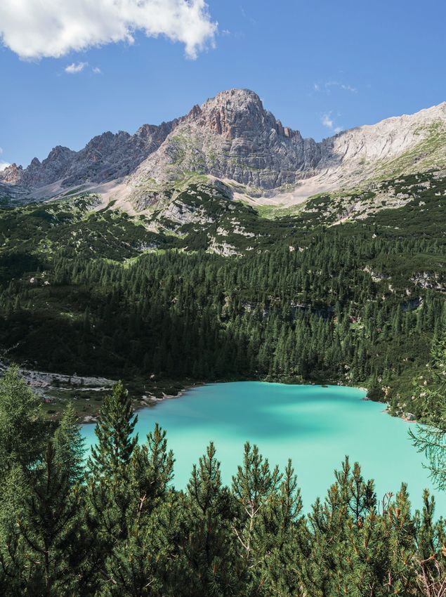
The Sorapiss lake, the turquoise mirror of the Venetian Dolomites
The easiest way to access it is the one that starts from the top of the
Tre Croci Pass (CAI 215 path): at the beginning easy, with little elevation
gain and wonderful views on Cristallo, Cadini di Misurina and Tre Cime di
Lavaredo, after it starts to be more challenging, with some via ferratas. The
itinerary is not impossible, but requires a bit of focus and caution, which
will be greatly rewarded when your eyes will finally see the incredible
shimmering turquoise of the lake waters. Overlooked by the pinnacles of
the Sorapiss group and by the majestic “God's finger”, the lake is nestled in
an evocative juxtaposition where spurs of bare rock, pinnacles and vertical
sides alternate with gentle slopes, fields and mugo pine shrubs.
A corner of delicate beauty, whose integrity is given to everyone's
responsible approach.
7
THE ALPINE PATH OF
THE DOLOMITES 4

It's also known as the Grohmann trail, in memory
of the mountaineer, founder member of the
Österreichischer Alpenverein, who first mastered the
giants of the Dolomites along this route. It connects
San Candido – Innichen (Bolzano) to Pieve di Cadore
(Belluno) in 6 stages and 85 kilometres. The trail
starts from the pretty village of San Candido, in front
of the peaks of Tre Scarperi and Croda dei Baranci
and it quickly leads to the magnificent terrace of
the Locatelli hut on the Tre Cime di Lavaredo. From
here to the Auronzo hut, you can choose the most
tourist, easiest and panoramic path or you can pass
through the forcella Col di Mezzo in a magnificent
environment, isolated and quiet. Afterwards, the trail
climbs up through paths and galleries that were built
by Alpinos between 1915 and 1916. From the Fratelli
Fonda Savio hut, three paths and one via ferrata
lead to the Città di Carpi hut. The view on Sorapiss,
Marmarole and Cristallo is amazing, while you're
walking towards the Vandelli hut. The via ferrata that
leads to the Comici bivouac, over the Ansiei Valley,
through rock jumps and ledges, is very technical.
Here, you can choose between two ways: the isolated
protected climbing trail Minazio or the long trail
through mugo pines and screes, that leads to the
Galassi hut in front of the Antelao Mount, the “King of                 Starting Point Ending Point   Average        Distance
the Dolomites”. The last stage is worthy all the effort,                San Candido Pieve di          walking days   85 km
just for the amazing view on Spalti del Toro, Cridola                                  Cadore         media 6

and the southern ridge of Marmarole from the Antelao
hut. The descent leads first to the village of Pozzale
and then to Pieve di Cadore, the city of Titian.

   There are two names that are at the beginning of the mountaineering
   history of the Dolomites: John Ball and Paul Grohmann. Ball, Irish politician
   and naturalist, first president of the English Alpine Club and founder of the
   Alpine Journal, in 1857 climbed the Pelmo, becoming the first man who
   conquered a Dolomite peak, and in 1858 created the first mountaineering
   magazine, the “Peaks, Passes and Glaciers”. But the so-called “father of the
   Dolomites” is Paul Grohmann, co-founder of the Austrian Alpine Club. In
   rope team with specialised and trusted guides as Santo Siorpaes, “Checco”
   Lacedelli, Peter Salcher and Franz Innerkofler, he climbed and conquered
   Tofane, Marmolada, Cristallo, Antelao and Civetta. His most famous
   achievement is the opening of the Via Normale on Cima Grande of the Tre
   Cime di Lavaredo in 1869.
   A monument in Urtijëi and a street in the city centre of Cortina d'Ampezzo,
   besides the Alta Via 4, are dedicated to him.
THE ALPINE PATH OF
THE DOLOMITES 5

Dedicated to Titian, it reaches Pieve di Cadore
(Belluno) from Sexten in the Puster Valley (Bolzano),
through the magic atmosphere of the Marmarole,
beloved and painted by the great artist. 7 stages
and 90 kilometres on trails of great mountaineering
interest, that we recommend to experienced hikers.
It starts on comfortable trails passing through the
“Emil Zsigmondy - Emilio Comici” hut and through
the Carducci hut, admiring the sides of Croda da
Toni, after descending towards the Giralba Valley
to the bridge Da Rin. From here, you enter the wild
Marmarole group, dear to Titian, climbing up to the
Ciareido hut on a wonderful terrace.
From the near Baiòn hut, you enter the Baranci
mountain range, on the trail used also by Pope John
Paul II, reaching the via ferrata “Sentiero degli Alpini”.
The difficulty of the climb is greatly rewarded by
the amazing view on Propèra, Cadini di Misurina
and Tre Cime. The possible variants to reach the
Tiziano bivouac are several. From here, the so-called
“Sanmarchi Trail” starts, from the name of the founder
of this Alta Via, the famous “Captain Barancio”, that
introduces to the most desolated and severe part of
all the trail. It's an itinerary not to underestimate that
climbs up steeply, crossing the Musatti and Voltolina
bivouacs, as if it was a continuous via ferrata. From
the San Marco hut, a path leads to the small forcella.
From the Galassi hut, the view is spectacular. You go
on through the Inferior Glacier and, among ledges and
narrow smooth ravines, start the long descent that will
lead first to the village of Pozzale and then to Pieve di
Cadore, where Titian's home deserves a visit.

                                                             Starting Point Ending Point   Average        Distance
                                                             Sesto          Pieve di       walking days   90 km
    Titian, symbol of the Italian art, was born in                          Cadore         media 7
    Pieve di Cadore at the end of the 15th century.
    He left the Cadorine valley when he was very
    young and went to Venice, where he became
    Painter of the Republic of Venice, but he never
    forgot his Dolomites.
    He was the first to catch their sublime beauty:
    he always immortalized their wonderful profile
    and unique light on the background of many
    paintings, introducing the Dolomites to the
    courts of all Europe. His home, in the main
    square of Pieve di Cadore, can be visited still
    today and, with its rustic furniture and the
    walls covered in wood, keeps the charm of the
    Cadorine style.

9
THE ALPINE PATH OF
THE DOLOMITES 6

The Alta Via “of silence” starts at the source of the          These mountains, known since the beginning of
Piave river in Sappada (Udine) and finishes in Vittorio        the mountaineering history, for long time left
Veneto (Treviso) after 180 kilometres and 11 stages.           out from the famous itineraries, because of the
It's part of the European Alta Via 6 that from the             impracticability of the access ways, in the first
Großglockner reaches the Peralba. The eight minor              decades of the nineteenth century became the
groups that it crosses and the isolated areas explain          scene of the race to conquer the Campanile
well the name of this route. The long traverses, the           of the Montanaia Valley, a 300 metres high
19000 metres of elevation gain, the lack of water and          amazing pinnacle, known also as “the rock
the rare footholds make this trail suitable for expert         scream”. Nevertheless, they keep still nowadays
and well-trained hikers.                                       their wild nature that make particularly hard its
A lonely path, perfect for those who want to taste             access. But the lucky hikers who reach it have
the wild nature of the Dolomites. From the Sorgenti            the opportunity to comprehend one of the most
di Piave hut it passes the Olbe lakes and, through the         sacred soul of the mountains: silence.
huts Fratelli de Gasperi and Ten. Fabbro, it reaches the
pastures of the Razzo plateau. After the Mauria Pass
and the Giaf hut you'll reach the easy traverse that
runs along Cridola, Spalti di Toro and Monfalconi. The
view from Scodavacca is amazing.
From the Padova hut you'll enter the harshest part
                                                           Starting Point Ending Point   Average        Distance
of the route: the stretch that leads to the Greselin       Sappada        Vittorio       walking days   180 km
bivouac has parts that have Grade II and III of                           Veneto         media 11
difficulty. You can bypass it descending through the
Cimoliana Valley in the Dolomiti Friulane National
Park. From Cimolais you'll climb again up to the
shelter in Col Nudo, obtained by a natural cave just
under the Valbona Pass. We recommend to try
sleeping in this austere building. The traverse towards
the Semenza hut and the descent to Vittorio Veneto
allow you to enjoy the wonderful views on the Alpago
basin and on the Santa Croce lake.
THE ALPINE PATH OF
THE DOLOMITES 7
Dedicated to the Austrian mountaineer Lothar Patera
is one of the most difficult Alta Vias. 36 kilometres
in 5 stages, completely on the limestone ridge of the
Col Nudo – Cavallo group. Exposed and dangerous
stretches, rock jumps and vertiginous views on the
Alpago basin, on the Piave valley and on the Carnic
ridges make it a route that requires athletic and
technical training, but that gives pure amazement.
We recommend it to experienced hikers, able to be
sure-footed and to adapt to rest in bivouacs and
shelters. It starts from the Dolomieu al Dolada hut
and there is immediately a first deviation to the top of
the mountain to enjoy the amazing view. Continuing
on the ridge you'll reach the Valbona Pass, with its
legends of smugglers and brides. After a night in the
shelter in Col Nudo, there is the challenging part on
the via ferrata “Rino Costacurta”. The view from the
top of Crèpon is astonishing. From Forcella Venàl, thin
paths lead to the Toffolon bivouac through pastures.
The connection from the Mount Mèsser to the top
of the Brutt Pass requires some mountaineering
experience to pass a brief exposed stretch. You
reach then the Lastè bivouac and the Semenza hut.
Continuing in other via ferratas, an easy climb to the
south-western ridge of the Mount Cavallo leads to
an evocative view on the Cansiglio forest, the Great
Forest of Oars of the Republic of Venice. Here the trail
finishes, descending to Tambre.
Besides the incredible variety of situations,
views and landscapes, the Alpago basin is
known also for its delicious food and specialities
that you can taste only here, as for example Starting Point Ending Point Average Distance
rif. Dolomieu Tambre walking days 36 km
the Alpago lamb or the Mame, variety of bean al Dolada medi 5
with a unique taste that is farmed exclusively
in this area, as well as the excellent cold cuts
and cheese and, more recently, the excellent
wine. Extraordinary raw materials in an
enchanted land. So, it's not by chance that
Alpago is a coveted destination also for haute
cuisine lovers, boasting two Michelin starred
restaurants: the Locanda San Lorenzo in Puos
d'Alpago, behind the Santa Croce lake, and the
Dolada in Pieve d'Alpago, on the Mount Dolada.
Both tell an almost centuries-old tale, a family
saga made of love for the territory and food
excellence.
11THE ALPINE PATH OF THE DOLOMITES 8 From Feltre (Belluno) to Bassano del Grappa (Vicenza), the Alta Via “of the Heroes” passes through the territory of the Grappa Massif, retracing the places of the Great War. 4 stages that connect the Piave Valley to the Brenta Valley in 63 kilometres. Technically simple, but with few footholds, it requires ability to organise and adapt, also because of the difficulty to find water. The route starts from the wonderful city of Feltre and, continuing to Porcen, climbs up to the Mount Tomatico through a comfortable cart track. From its top, you can enjoy the view on the Valbelluna, with the majestic Dolomites on the background. From the wide glade of Malga Pàoda the view expands on the ridge of the Prealps, with the Mount Cesen that overlooks the Piave valley. The itinerary, evocative any variant you choose, continues to Malga Dumela. From here, it continues to the Bassano hut and, crossing Col de l'Orso, reaches the heart of the Mount Grappa, Sacred to the Country. Military paths, trenches, bunkers and commemorative plaques remember the Heroes who here defended Italy and Italians until the last drop of life, with highest sacrifice and audacity. In Cima Grappa you can visit the War Memorial, monumental cemetery built in 1935 in memory of the fallen soldiers of the Great War, where the impressive holiness of the place combines Starting Point Ending Point Average Distance with the peacefulness of the landscape. The descent Feltre Bassano del walking days 63 km is through military paths and streets, as the “Cadorna” Grappa media 4 and the “Strada militare di arroccamento”, to Bassano del Grappa, where you must not miss a visit to the Ponte Vecchio. With its wonderful views, its sides and heart marked by kilometres of trenches, galleries, caves and cart tracks, the Mount Grappa is one of the most vivid symbols of the Great War. The soldiers resting in the ossuary in Cima Grappa are 22910, of which 20332 without identity. It's a place of reflection with its “ways of heroes” that symbolically connect the Italian ossuary to the Austro-Hungarian one. It is also a place of heroic deeds. One above all, necessary and determined, the one of the 15th of June 1918 that saw the 9° Reparto degli Arditi (9th Unit of the Daring Ones) pushing the Austro-Hungarian Army back, who, occupied Col Moschin, thought to have conquered the way to the Venetian plain. The trenches and galleries that are accessible still today are several on this mount that was changed in fort, symbol of the Italian Resistance. Soldier Peter Pan's grave is the symbol of these young people's sacrifice.
THE ALPINE PATH OF
THE DOLOMITES 9

Called “la Trasversale”, it is the only Alta Via that          Enthusiast of mountain landscapes, Carducci
does not follow a northern-southern course, but a              chose the Cadore area many times when finding
western-eastern one. 180 kilometres that from Lavina           inspiration. He stayed in Caprile in 1886 and saw
Bianca (Bolzano) lead to Santo Stefano di Cadore               for the first time the beauty of the Dolomites.
(Belluno) in 14 stages, following the ridge line that          He returned in 1892 and visited Pieve di Cadore,
from the Scillar goes to the Visdende Valley. The trail,       Auronzo and Misurina, where he wrote the
long but easy, twists and turns in frequented areas            central part of “Ode to Cadore”, where the
with many footholds. Climbed some comfortable                  feelings caused by the incomparable landscapes
paths, you'll walk the southern ridge of Catinaccio –          of this area of the Dolomites, that was annexed
Rosengarten, passing through the Sassopiatto hut,              some time before to Italy, are heart and support
Piz Boè and the Campolongo pass to the Pralongia               to the Renaissance patriotism that animated
hut. The view on the majestic Sella and Sassolungo             him. He was immediately loved by the people
groups is magnificent. Reached the Eastern Dolomites,          of the Cadore area and after his death, they
you'll climb to the the Valparola and Falzarego passes.        dedicated a street, a pyramid and a mountain
From the unmissable view of the Lagazuoi hut,                  hut to him.
through the easy but vertiginous via ferrata Astaldi,
you'll reach the Pomedes hut, that overlooks Cortina.
The stretches through the ledges on the sides of the
Tofane allow you to admire the amazing geological
formations. From Cortina d'Ampezzo, you'll climb
up to Cristallo, to the Son Forca hut: from here, a
beautiful path leads you to Cadini di Misurina and to      Starting Point Ending Point   Average        Distance
                                                           Lavina Bianca S. Stefano      walking days   180 km
the Col de Varda hut, finally reaching the Auronzo                        di Cadore      media 14
hut, walking on via ferratas and on an ancient military
path. After the Carducci hut, the route becomes
more impressive, following the Strada degli Alpini
(via ferrata) to the Sentinella Pass. It descends then
through Vallon Popera to the Berti hut and, crossing
the forcella dei Camosci, it reaches the Piovan
bivouac. With wonderful views on the Comelico
Valley, it goes to the S. Antonio pass and then Danta,
with a view on the Piave Valley, descending then to
Santo Stefano di Cadore.

13
THE ALPINE PATH OF
THE SHEPHERDS
Hike that twists and turns through the centuries-old
woods of the Biois Valley and the high pastures of the
mountains that surround it. 6 stages on gentle paths,
never too hard, among malgas and shelters, proof
of the lively shepherd activity that has characterized
this area for centuries. Starting from the hamlet of
Bogo, you'll climb through one of the most impressive
part of the San Lucano and Gares valleys, reaching
first Malga dei Caoz and then Malga Campignat.
Continuing to Capanna Cima Comelle, we recommend
the deviation to Cima Pape, that, even if tiring, is
worthy trying because it leads to a wonderful view on
the most famous peaks of the Dolomites. From Pian
de le Giare through the village and the fall of Gares,
it climbs to forcella Stia to the Mulaz hut. Pastures,
cottages and lodges for the hay harvest follow one
another along the trail that through the Malghe Valés
Bas and Valés Alto, leads to the Valles Pass and
continues to the San Pellegrino Pass. It continues then
to the malga dei Zinghen Alti, malga Zinghen Bas
to the Flora Alpina hut, climbing up then to Pian de
la Schita to the panoramic passage on Forca Rossa.
Crossed the Auta towers and the Col Mont lodge,
there is a more difficult part, that requires some
training. The route, impressive but arduous, climbs
up to forcella Negher then descend to forcella delle Starting Point Ending Point Average Distance
Fontane, crossing the slopes of the Pezza group. It Bogo di San Simon walking days 30 km
Cencenighe
climbs again up to forcella Sciota and to the Sasso Agordino
di Vallada media 3
Bianco hut, with an exclusive view on the southern
side of Marmolada. The trail, descending towards the
hamlets of Costoia and Canacede, finishes in Vallada
Agordina, on the San Simon hermitage, national
monument that keeps a prestigious altar by Flugel and
frescoes by Paris Bordone.
The MusAL Albino Luciani Museum, inaugurated in August 2016, is in Canale
d'Agordo, geographic centre of the Biois Valley and Albino Luciani's home-
town, that is Pope John Paul I. It houses an interactive collection about the
Smiling Pope's life and education and some tours that describe the historical
and social background where Luciani was born and grew up, a fundamental
factor to understand his peculiar personality. The museum houses also a section
dedicated to the Biois Valley. The palace that keeps the exposition dates
back to the 15th century: created originally as wayfarers' lodging, nowadays
it welcomes thousands of pilgrims and several visitors every year, attracted
by Albino Luciani's human figure. Of the ancient lodging you can still admire a
fresco, representing Christ risen from the tomb.THE HIGH ROUTE OF
THE BEAR
Inspired by the novel “The bear skin” by Matteo
Righetto, this new Alta Via was inaugurated in August
2019. A fascinating trail that retraces the steps of
the protagonists of this famous novel, busy with the
research of “El Diàol”, a bear that terrorises the village,
but that will inevitably lead them to a strict connection
with uncontaminated nature. A circuit suitable to
everyone, a real literary trail that from the Fiorentina
Valley leads to Livinallongo del Col di Lana, following
the ancient Strada de la Vena. The starting point is
in Colle Santa Lucia and quite soon you'll feel as if
you were in the suggestive atmosphere that flows
on the pages of Righetto's novel. The path clambers
on the charming and wild landscapes of the Pore
massif, of the Nuvolau – Averau group, descending
then on the Fodòm – Livinallongo del Col di Lana
slope, where it meets the ancient Strada de la Vena,
eventually returning to Villagrande, near Colle Santa
Lucia. It will be easy, for those who know the story,
identifying the trip that father and son, protagonists
of the novel and of the film with the same title, that
was shot exactly here, make to find the bear. A trip of
few and moderated words that will lead them to find
themselves and their relationship. A trip that leads
the hikers to identify with the protagonists, so much
that they can feel their emotions. 10 kilometres in 10 Starting Ending Point Average Distance
stages, scanned by pieces of the book, accurately Point Livinallongo distance 3 10 km
del Col di
chosen by the same author. Colle Santa
Lana
ore
Lucia
A touching trip, almost mystic, in a landscape of
extraordinary beauty.
In the old centre of Villagrande, in Colle Santa
Lucia, just a few steps from the church, you can
admire the Chizzali – Bonfadini palace.
It is unique, with its window bars, made with
the “Ferro dell'Agnello” (Lamb Iron), coming
from the Fursil mines, owned by the family
that once lived here. Built in 1612, the palace is
decorated with precious frescoes and today
the Istitut Ladin Cultural Cesa de Jan has
here its offices. This is an association that has
been safeguarding and promoting the Ladin
identity and traditions since 2004. Curated by
the Istitut, in the rooms of the palace there is
the museum, a tour in 4 sections that tells the
Ladin past in Colle Santa Lucia, also through the
industriousness of its people.
15“AMELIA” HIGH ROUTE
High-level hiking long distance route, tribute to the Natural area, safeguarded since the period of
first pioneer of the Dolomites, English novelist Amelia the Republic of Venice, during the centuries
Edwards. The itinerary of this Alta Via crosses all the forest of Somadida passed first to the
the peaks described in her book Untrodden Peaks French Navy, then to the Lombardo-Venetian
and Unfrequented Valleys, where Edwards holds all Kingdom, finally annexed to the Kingdom of
the emotions of a unique trip, made of nature, inns, Italy and declared unalienable good in 1870. The
people, statues and colours never seen before. Written reserve is in the northern part of the province
after her trip in 1872, in a period when very few people of Belluno, framed by the Mount Cristallo, the
ventured through these wild lands, the work by Tre cime di Lavaredo and Sorapiss. It's a place
Amelia allowed many foreign travellers to know the of incredible flora/fauna value, included in 1676
extraordinary beauty of the Dolomites. As occurred hectares, and inside you can find tracked trails
in 1872, the route starts from the Aquila Nera hotel both for beginners and experienced hikers.
in Cortina and in 30 days, passing all the peaks that We recommend to visit the Biblioteca del
Amelia admired at that time from the valleys below, Bosco (Library of the Wood), at the entrance
reaches the Bad Ratzes hotel, at the foot of the Seiser of the reserve, that is an educational initiative
Alm. The basic route is divided in 30 stages, for 400 dedicated to Dolomite nature and legends,
kilometres and 10000 metres of elevation gain, but it and the Giardino delle Farfalle (Garden of the
offers variants in 20 stages, when there are paths of Butterflies), a delimited area where you can
historical interest or more difficult via ferratas. observe several local species.
During the trail the experienced mountaineers can
test themselves climbing the highest 10 tops of the
Dolomites. The route is divided in 4 sections that can
be completed in different periods: the first, the tour
of Cortina, that passes through Antelao, Marmarole,
Tre Cime and Cristallo; the second, the Tour of the
Primiero, that starts and comes back to Caprile, Starting Point Ending Point
Cortina Alpe di Siusi
Average
walking days
Distance
400 km
crossing Marmolada, the Pale di San Martino and the d'Ampezzo media 30
Dolomiti Bellunesi National Park; the third, the Tour
of Zoldo that passes through Civetta, Pelmo, Moiazza
and Bosconero; the fourth, the last one, that from
Caprile leads to the Seiser Alm.CADORE CROSS
PATH
This itinerary rose thanks to the enhancement of the
ancient trail heritage of the Cadore area: it starts from
Auronzo di Cadore and finishes in Caralte di Perarolo.
75 kilometres that unite pre-existant paths, that you
can walk or ride, also by old people and children.
Given its great simplicity, the itinerary allows you to
fully enjoy the beauty of the landscapes and at the
same time it reveals the ancient ways of connection
that the Cadorine people developed and used during
the centuries to move. The route is part of the
everyday routine of the inhabitants: as they are routes
created for the real needs to move, they pass through
every village, giving to the hikers the direct contact
without filters with the cultural and folk heritage of
the area. At the beginning, the itinerary goes along
the right bank of the Ansiei creek reaching Cima
Gogna. In Tre Ponti, the path divides in two sections:
the first continues along the Ansiei creek and, passing
through Lozzo, climbs up to Grea and Rizzios reaching
Calalzo; the second crosses the 52 state road and,
reached Vigo and Laggio, climbs up to Lorenzago,
then descending through the old street to Vallesella.
From Domegge, the itinerary becomes one again and
crosses Calalzo, Sottocastello and Caralte, reaching
then Perarolo. There are three entrance points to the
route, identified to enhance it at the best: the northern Starting Point Ending Point Average Distance
door in Transacqua in Auronzo, the eastern door in Auronzo di Caralte di walking days 75 km
Vallesella, nearly at the middle of the itinerary, and Cadore Perarolo media 3/4
the southern door in Caralte. Each door has a wide car
park, info-points and bike rent.
Lorenzago di Cadore, Park of the Dreams and Altar in the Wood.
Placed along the state road that connects the Cadore area to Carnia,
Lorenzago seems to be named after a Roman colonist, Laurentus.
Renowned resort centre already at the end of the nineteenth century, it
became famous worldwide with Pope John Paul II, who loved staying in the
peacefulness of its forests: the town dedicated a museum to him, located in
the former nineteenth-century parsonage, and an open-air sanctuary in the
forests of the Mirabello Castle. We recommend for those who are looking
for a quiet hike deep in the green, the circuit of the Park of the Dreams:
just outside the town there is this pretty itinerary that develops through
spurs and larks, where it's easy to meet roe deer and squirrels. Suitable to
everyone, it can be enjoyed also with mountain bikes.
1719
The Ways Of
The Dolomites
THE WAY OF THE
DOLOMITES
30 stages and more than 500 kilometres in the
spiritually most significant places of the province of
Belluno. An itinerary without dangers, that invites
introspection, in an extraordinary natural environment.
The Cammino starts from the Sanctuary of the Saints
Vittore and Corona, that overlooks Feltre, and goes
then towards the Mount Avena. From here you'll
continue on the path of the piedmont churches to
Sospirolo, where you'll find the ancient charter-house
of Vedana. Through the Imperina Valley, you'll climb
up to Canale d'Agordo, Pope John Paul I's home-
town. Continuing towards Vallada Agordina, you
must not miss a visit to the church of Saint Simon,
declared national monument in 1877; afterwards, in
the municipality of Rocca Pietore, the sanctuary of
Saint Mary of the Graces and the church of Saint Mary
Magdalene deserve a visit. This last has a precious
wooden German-style altar, created in Brixen in 1518
by Ruprecth Potsch's atelier, very rare in this area.
From here, it continues towards Livinallongo and
higher to the Falzarego Pass, where the wonderful
austerity of the Dolomites dominates the landscape.
From the plain of Fiames, it reaches Misurina and
descends then to Auronzo di Cadore. Passing Padola,
it reaches the Visdende Valley, called “God's temple,
hymn to the Creator” by bishop Muccin. Left the
Comelico area, it enters Vigo di Cadore, with the
amazing fourteenth-century frescoes in the church
                                                                          Starting Point Ending Point   Average        Distance
of Saint Ursula. In Lorenzago, the Way of the Popes                       Feltre         Belluno        walking days   500 km
retraces the places where Pope John Paul II used to                                                     media 30
walk to restore the spirit. Crossed Longarone, Alpago
and Nevegàl, it reaches the cathedral in Belluno. The
last part of the journey starts here, along the left bank
of the Piave river, that offers excellent examples of
sacred art, as the archpriest church in Lentiai with
the extraordinary coffered ceiling painted by Cesare
Vecellio, of the school of Titian.

     Through frescoed churches, charter-houses, abbeys and castles, the trail
     generously offers places with great historical and spiritual value. It starts from
     the Sanctuary of the Saints Vittore and Corona, nestled on the Mount Miesna,
     authentic jewel of Romanesque art with Asian and Armenian influence. Inside,
     you can admire precious frescoes of Ottonian art and by the school of Giotto.
     In the village of Masiere in Sospirolo there is the charter-house of Vedana,
     once place of contemplation and shelter for wayfarers, that houses today a
     community of cloistered nuns. You must not miss a visit to the church of Saint
     Ursula in Vigo, with its single enormous fresco that covers all the walls and
     tells the legend of the Saint. The War Memorial in Pian dei Selesi is touching:
     completely surrounded by the beauty of the Dolomites, its architectural design,
     made of open-air niches, intensely counterpoises the striking number of deaths
     to the quiet that today prevails in this place. Moreover, you must not miss a
     visit to the Andraz Castle (Livinallongo del Col di Lana) and the Zumelle Castle
     (Borgo Valbelluna).

21
THE WAY OF
THE POPES
Part of a group of European spiritual routes, it
offers itineraries surrounded by woods, created and
developed following the testaments of the faith
of four Popes who loved and lived the province of
Belluno. It has 15 stages with two possible starting
points. The first from Canale d'Agordo, Pope John
Paul I's home-town, from which it descends firstly
along the Biois Valley and then along the Cordevole
creek and the valley with the same name, reaching the
pleasant landscapes of the Dolomiti Bellunesi National
Park. Along the path you meet the charter-house
of Vedana, just few steps from the small lake with
the same name, the only example of not damaged
charter-houses in the Veneto region. The second from
Lorenzago di Cadore, in the places dear to Pope John
Paul II and Pope Benedict XVI, who here loved to
walk to restore the spirit, surrounded by the majestic
Dolomites. The route descends then along the
Piave valley, crossing Pieve di Cadore, Ospitale and
Longarone, reaching then Belluno. In the hamlet of
Mussoi, Pope Gregory XVI's home-town, the two trails
meet, continuing in the same single route towards
Vittorio Veneto (Treviso). The views that you can
enjoy passing through the Valbelluna to Anzù in Feltre
are impressive. Here there is the Sanctuary of the
Saints Vittore and Corona. Then, it goes back along
the left bank of the Piave river towards Lentiai, until Starting Point Ending Point Average Distance
Lorenzago passo di walking days 95 km
reaching one of the most beautiful villages in Italy, Mel di Cadore Praderadego media 4/5
in Borgo Valbelluna. From here, within the historical / Canale
d’Agordo
Diocese of Ceneda of Vittorio Veneto, it reaches the
Praderadego Pass.
Belluno, the capital of the Dolomites, is the home-town of two popes, born
under the shadows of the Pale Mountains and grown up under the World
Heritage rock cathedrals. The most famous of them is undoubtedly Albino
Luciani, born in canale d'Agordo and become Pope with the name of John
Paul I. Loved by the Italians, he is remembered as the “Smiling Pope” and
was never forgotten, also because of his sudden death, still mysterious
today, just after 33 days of papacy. In 1765, in Mussoi, hamlet of Belluno,
Bartolomeo Alberto Cappellari was born, Pope Gregory XVI from 1831 to
1846. He made the history of Rome, greatly implementing the number of
the Vatican Museums and building the park of Villa Gregoriana in Tivoli,
where today the FAI (National Trust of Italy) has its offices. But the paths,
the peaks and the woods of Belluno are linked also to two other popes, who
chose them as places to restore the body and the spirit: John Paul II and
Benedict XVI.PARK2TREK
Hike in 6 stages and 5800 metres of elevation gain,
the course retraces the final part of the Alta Via
2, leaving from Feltre and reaching San Martino di
Castrozza, in the province of Trento. The trail, varied
in the landscapes and degrees of difficulty, twists and
turns through the Dolomiti Bellunesi National Park and
the Paneveggio Pale di San Martino Nature Park.
There are some exposed stretches that require a
bit of mountaineering training or the presence of
experienced guides. The starting point is in Croce
d'Aune to the Dal Piaz hut, where the traverse of the
Vette Feltrine begins. From the wonderful Busa delle
Vette, it crosses the Piètena Pass and reaches the
suggestive and mysterious Piazza del Diavolo. The
part that passes the Sasso Scarnia is quite difficult and
the passage on the “stepladder” is striking, with empty
space on both sides. From the Finestra Pass, it reaches
the Boz hut, from which, under the sides of Sass de
Mura above, passing through the bivouac Feltre, you'll
climb up to the Comedon Pass. A hard descent of
1300 metres, at the beginning on sheets of the famous
passage of the Intajada (not to try when raining) and
afterwards on a scree, leads to Sagron – Mis. Then
you'll climb up to the forcella d'Oltro, reaching the
Treviso hut, and you'll enter in the area of the Pale di
San Martino. An interesting variation of the route leads
to the Canali Pass and to the Fradusta glacier.
From the glacier you'll hike down through
Starting Point Ending Point Average Distance
breathtaking views to the Pradidali hut, just under Feltre San Martino walking days 80,1 km
the pinnacles of the Pale and afterwards to the Canali di Castrozza medi 6
Valley. From here, with a shuttle bus service, you
can reach San Martino di Castrozza, with transfer
service booked in advance at the APT booking office.
If you still have strength, you can however walk to
the mountain huts Rosetta (possible descent on
cable-way) and Mulaz, through the Farangole Pass,
descending then to the Segantini lodge and finally to
San Martino di Castrozza.
Almost entirely uninhabited, the Dolomiti
Bellunesi National Park, with its 31000 hectares,
is a succession of rocks, plateaus, woods and
canyons, a masterpiece of biodiversity. A real
paradise for the wild alpine animals and for rare
plants that survived glaciations.
It houses a quarter of the national plant
heritage, some native. It's the house of
thousands of chamois, deer, roe deer and
mouflons, and here 115 species of birds and 20
amphibians and reptiles nest. In the area there is
also 40% of the species of butterflies in Italy.
23THE DOLOMITI
BELLUNESI ALPINE PATH
108 kilometres from Forno di Zoldo to Feltre, in the Climbing up from the Canzoi Valley, both if
Dolomiti Bellunesi National Park. The stages are 7 you choose the variant of the Porzil or the
with 6 variants and some sections that are part of the traditional pass, you'll have a view that take
Alta Via 1 and 2. Wild places and few footholds make your breath away: they are the Piani Eterni,
it an experience for real hiking pioneers, while the an extraordinary alpine pasture, scattered by
protected nature in the area requires a strict respect karstic rocks and covered in mugo pines and
of the rules. The climb to the Pramperet hut and the rhododendrons. The hard climb to reach them,
descent from the Bianchet hut offer wonderful views rewarded by an almost unreal silence, the
on the majestic Pelmo, “el caregon del Padreterno” unique perfumes and colours reveal, no further
(local name for “God's throne”), and on the Schiara words needed, the reason if this name, eternal
group, with the “Gusela del Vescovà”, iconic rock plains, simply perfect to describe this enchanted
pinnacle, beloved by the inhabitants. You'll continue plateau that hides wonders also behind the
in the area of the Monti del Sole, among the dark and surface: a tangled underground world twists
impenetrable valleys that characterize them. After and turns for kilometres in galleries and caves,
the passage through the wide karstic pasture of the the deepest of which reaches 1000 metres.
Piani Eterni, at 1700 metres, the trails are getting
vertiginous. Ledges with fixed ropes lead to the
majestic rock sides of Sass de Mura and the Vette
Feltrine. For the less experienced, you can bypass
it, walking less spectacular but easier paths, losing
altitude. From the Bruno Boz hut to the Dal Piaz hut,
you'll continue surrounded by an area of Integral Starting Point Ending Point Average Distance
Forno di Feltre walking days 110 km
Nature Reserve. The walk during the blooming season Zoldo media 4/5
on the Busa delle Vette is wonderful, surrounded by
mouflons and chamois; from here, among coloured
and luxuriant flora, you'll go on in a place where the
legends of devils and witches still resound. Finally,
you'll walk on a cart track first and then on a street
towards Feltre, passing through the Croce d'Aune
Pass and Pedavena, place where the historical
brewery is.THE ALPINA
YELLOW WAY
It starts from Oberstdorf in the Bavarian Allgau and
finishes in Trieste, but originally was travelled from
Italy to Germany. 750 kilometres divided in 5 thematic
trails: the first is “Hiking Passion” that arrives in
Landeck in Austria. From Tyrol to Bolzano the trail
dedicated to Otzi. The second and third trails, from
Bolzano to Calalzo di Cadore, dedicate 131 kilometres
in 26 stages to the Dolomites, recognised World
Heritage by UNESCO and to the Great War scenarios.
The route passes through all the most famous
mountains of the Dolomites and often crosses the
historical line of the front. Among the most suggestive
points, there is the German War Memorial at the
Pordoi Pass that keeps at 2239 metres the remains
of the Austro-Hungarian fallen soldiers, with a view
that overlooks the beauty of the Piz Boè group and
the Padon range, with Sass Ciapel. On the Pian dei
Salesei there is the Monumental Cemetery dedicated
to the Italian fallen soldiers. Always in the municipality
of Livinallongo del Col di Lana, the Monte di Sangue
Museum shows pictures of soldiers from the two
fronts, relics and reproductions of the trenches.
Descending, the Ladin Ethnographic Museum in Pieve
di Livinallongo and the Andraz Castle deserve a visit.
Going back to nature, the views that the lakes offer
are wonderful: the landscape that you can admire
reaching the Fedaia lake at the foot of Marmolada is
dreamy, the Baste lake on the Giau Pas is enchanting
and the small lakes in Lagole of Calalzo are full
Among the treasures guarded by the Dolomites,
of legends. The third section “Alpine Wilderness”
the rich tradition of legends, well-established in
leads from Calalzo to Gorizia. A long traverse of 325
several folk tales and passed down until today,
kilometres in 30 stages through the wildest part of
deserves a special place. Legends that tell
the Eastern Alps. The views on the steep crags of
mysterious figures, kings and knights, witches
the Spalti del Toro and of the Montanaia Valley are
and beautiful girls and unconquered nature
wonderful. The last stretch from Gorizia to Trieste is
that hides disquieting figures in its ravines as
dedicated to enogastronomy.
for example, the Mazzarol (fantastic creature
dressed in red), the Om Selvarech (hairy wild
man of the wood) or the Anguane (female
water creatures). The story of the Anguane
in the De la Femenes lake, better known as
the “laghetto delle tose” (small lake of the
Starting Point Ending Point Average Distance
passo Pordoi rifugio walking days 79 km girls), near the archaeological area in Lagole in
Padova media 3/4 Calalzo is tragic: this is a place that was once
popular during the centuries for the healing
powers of its water and the legend tells that
here the Anguane, envious of the women of
the village, who used to take a bath in the lake,
one day killed them one by one, while the men
were hunting. The lake god, furious for what
happened, poisoned the waters so that the
same Anguane died as well. Afterwards, the
water became healthy again.
25DOLOMITES ROCKS
MINIATURES
To touch with hand the most beautiful peaks of the 9
systems of the World Heritage Dolomites: this is the
dream that the Path of the Dolomites in miniature
gives as a gift. The project, in the municipality of San
Tomaso Agordino and patronised by the UNESCO
Dolomites Foundation, wants to give the opportunity
for everyone to admire, even if reproduced in one-to-
one scale, the wonderful complexity of the profiles
of the most beautiful mountains in the world. The
works are ten at the moment, created by selected
artists from different countries, in a project that
develops with new works every year. The first three
reproductions date back to 2017: the Pelmo, by
Mauro Olivotto “Lampo” from Cadore, the Tre Cime
di Lavaredo, by the German artist Susanne Pauker,
and the Civetta, made by the Italian-Australian Franco
Daga. In 2018, the Belltower of the Montanaia Valley
was created by the Uruguayan Gisella Garcia, the Torri
del Vajolet was made by Pierangelo Giacomuzzi, from
the Trentino region and the Mount Antelao was made
by the Ecuadorian Mario Tapia. For the 2019 edition
the artists Maria Trinidad Caminos (Argentina),
Andrey Balashov (Russia), Sebastien Taille (France) e
Paolo Moro from Belluno recreated the magic of the
Dolomites sculpting El Cor on the Pale dei Balconi, the
Campanil Basso of the Brenta, the Marmolada and the
Tofana di Rozes with the Castelletto, stronghold of the
Great War. The artworks, all obtained from Dolomite
blocks of the Serla extracted from the San Tomaso
quarry, are placed along the silvopastoral street that San Tomaso zip-line:
from Celat of San Tomaso Agordino climbs up to the a fast-paced experience in total safety that
forcella San Tomaso. allows to discover the beautiful municipality of
San Tomaso Agordino from a new perspective.
Started in 2012, it's the highest zip-line of the
Dolomites: it is 1600 metres long with 260 metres
of elevation gain. In the point of greatest slope
it allows the visitors to reach the considerable
speed of 80 kilometres per hour. The view on
San Tomaso Agordino, Pelsa, Civetta and the
Starting Point Ending Point Average Distance Cordevole valley is extraordinary. The starting
San Tomaso San Simon walking days 8 km
Agordino di Vallada media 1 point is in Celat, where you climb up to Canacede:
Agordina
here, worn the climbing harness and followed the
strict safety procedure, you descend to Costoia
and you'll reach again the square in Celat. The Zip-
line is open from June to September.THE TRAIL OF THE
HOSPICES
Developed on the trails which once were used by
those who walked the hard trip of the Cordevole
Valley, this route was named after three hospices
that during the Middle Ages were built to support
the wayfarers: the hospice of Vedana, that became
charter-house in 1456, the hospice of Candaten and
the hospice of Agre. The route starts from the charter-
house of Vedana, passes through San Gottardo,
climbs up to Salet and continues through fields
where it's easy to meet chamois and horses grazing,
before entering again the wood and returning to the
Cordevole creek near the hospice of Candaten, on
the other bank of the creek. From here it continues
to the outlet of the Valley of Montareze, where we
recommend to take a deviation on the Zanardo Nature
Trail to admire the Ru de le Montareze falls. Returned
on the route, the trail climbs up to Col dei Porz, where
there is the hospice of Candaten and then it descends
to meet again the Cordevole. It continues climbing
up the Pergolera Valley, that was named after the tar
production obtained by the resin of the scot pines that
are many here, crosses the Vaion gorge – impressive
ravine whose track is however wide and safe – and
continues towards the Valon dei Zoldani.
Passed Casera delle Fratte and the Mus Valley with
its characteristic waterfalls, it continues to the bridge
on the Pergolera creek, with its rock pinnacle called
the Pergolera Gendarme, and arrives to the Agre
Starting Ending Point Average Distance
plain with its hospice. Through the Castei canyon, it Point Val Imperina distance 20 km
reaches the Taiada de San Martin, where it is said that San Gottardo 6 ore
the Saint saved a boy drowned in a lake, cutting the
rock and draining the water. It goes on to Sass de San
Martin, where once there was the Castle of the Agordo
area, and then descends to Pian dei Nof and finally
arrives to the mines in the Imperina Valley.
Imperina Valley mines center. Located in the municipality of Rivamonte,
they were for more than five centuries among the most important mines in
Europe. Mainly known for the mining of the curpiferous pyrite, necessary
to the copper production, they are an important example of industrial
archaeology. The area, that has been for years object of a massive recovery
work, combines an open-air museum with perfectly preserved sections,
as the forges, the crushing, grinding and washing systems and the former
hydroelectric power plant that houses a museum dedicated to the valley
inhabitants. Returning to Agordo, you must not miss a visit to Crotta – de'
Manzoni Palace, the northernmost of the Venetian villas and once house of
the family owner of the mine centre.
27“DINO BUZZATI” TRAIL
It's the Prealpine trail dedicated to the great writer
and journalist from Belluno, that retraces one of the
strolls that he loved to walk the most, surrounded by
that nature which was so deeply entrenched in him
and which often inspired his work. A gentle path, long
just about 8 kilometres, surrounded by the magic of
the woods that alternates with the freedom of the
wide fields, with romantic glimpses on the Valbelluna
and views on the Dolomites, from Schiara to the
Mount Serva. Retracing Buzzati's footsteps, the path
starts from his home, in the village of San Pellegrino,
just outside Belluno, and continues towards Giaon in
Limana. From here, a cart track climbs up meandering
among trees and the roadside shrines for the Stations
of the Cross of the Madonna of Parè, coming shortly at
the entrance of the sacred place with the same name.
Not far away, there are three big crosses and the
remains of a prehistoric fortified village.
The path goes on towards Valpiana and crosses first
the ancient roadside shrine of Laste – that seems to
have inspired Buzzati's tales – and then the sacred
place of Saint Peter in Tuba, built on the remains of an
ancient castle, once lookout post on the Piave valley.
The glimpse that from here opens to the Dolomites
is amazing. Reached Baita degli Alpini in Valpiana,
you can go back walking the same path or you can
continue towards Valmorel, with its white birches that
interrupt every now and then the gentle rise and fall of
the fields. Vamorel was dearly loved by Buzzati for its
quiet and mysterious atmosphere. From here, a steep
dirt climb rejoins the path done before, where the
sacred place of the Madonna di Parè is.
"The Miracles of Val Morel",
"The Secret of the Old Woods". Starting Ending Point Average Distance
Point Giaon di walking days 8 km
It will be a pleasure to recognise somewhere San Limana media 1
in the stories, suspended between fantasy and Pellegrino
fiction, the landscapes, the roadside shrines,
the woods seen along the path. It will be easy
to understand the magic signs and the sacred
respect to nature that we find in “The secret of
the old Woods”. As well as it will be impossible
not to recognise some views, perfectly visible
still today, of the scenes told in “The Miracles of
Val Morel”, discovering, line by line, the ability
with which a skilful literary fiction melts into
reality. It's magic the way how Buzzati takes us
to his soul places, re-elaborated in a way that
they seem to belong to us, and to cross sections
of life experience, as in a kind of testament.“VENA” CROSS PATH A trail of high historical-cultural value, retracing the Andraz Castle. ancient Via del Ferro (Iron Way) that connected the Medieval fortalice shielded by a rock spur, Fursil mines, at the foot of the Mount Pore near Colle it was a strategic placement that protected di Santa Lucia, to the furnaces of the Andraz Castle the episcopal interests from the expansionist and the passage of Valparola. An easy trail, that goals of the Republic of Venice. It was part of a follows paths and cart tracks, with unique views on fortification system that assured a total control the Fiorentina Valley and on the Fodòm Valley. over the trades between the Agordo area A wonderful hike, well-marked and without great and the Puster Valley. Its history, that you can elevation gains, to know better the events and the retrace in the rooms of the inside museum, tells disputes for the property of this important mining the gradual anthropization of this area, started activity between Tyrol and The Republic of Venice. with the hunters during the Mesolithic Age, who The guided tour to the Fursil mines – just during the here stopped, and developed then to create the summer season – could be introductory: here they building that we see now. With its architecture, mined siderite, mineral that once liquefied acquires that is perfectly integrated with the rock spur properties similar to steel, making it esteemed in all that is the basement, it's an extraordinary Europe. The path, that twists and turns through larch example of the fusion of man and nature and spur woods, starts from the square in Villagrande that makes the Dolomites a World Heritage in Colle Santa Lucia and continues along the state recognised by UNESCO. Among the Sirs of the road towards Selva di Cadore. Crossed the bridge on Castle we remember the bishop-philosopher the Ru de la Pavia, the street leads to the entrance Nicola Cusano. of the galleries of the Fursil mines. From the mines a comfortable cart track leads to the Pianaz and, from here, passes through the suggestive semicircle valley overlooked by the Mount Pore. Crossed the villages of Ruiz and Zopei, it reaches Forzela in an area of significant naturalistic importance. The path becomes a comfortable cart track and through woods leads to Livinallongo. After the wonderful hamlet of Col de Larzonei, it crosses the Andraz – Nuvolau trail and reaches the Andraz Castle through the woods. Starting Point Ending Point Average Distance Colle Santa Castello di walking days 15 km Lucia Andraz media 1 29
You can also read