The Central Arizona Conservation Alliance Programs: Use of Social Media and App-Supported Community Science for Landscape-Scale Habitat ...
←
→
Page content transcription
If your browser does not render page correctly, please read the page content below
land
Article
The Central Arizona Conservation Alliance Programs: Use of
Social Media and App-Supported Community Science for
Landscape-Scale Habitat Restoration, Governance Support,
and Community Resilience-Building
Aireona B. Raschke *, Jeny Davis                   and Annia Quiroz

                                          Desert Botanical Garden, Desert Horticulture and Conservation, Phoenix, AZ 85008, USA; jdavis@dbg.org (J.D.);
                                          aquiroz@dbg.org (A.Q.)
                                          * Correspondence: araschke@dbg.org

                                          Abstract: Land managers are currently faced with a nexus of challenges, both ecological and social,
                                          when trying to govern natural open spaces. While social media has led to many challenges for effective
                                          land management and governance, the technology has the potential to support key activities related to
                                          habitat restoration, awareness-raising for policy changes, and increased community resilience as the
                                          impacts of increased use and climate change become more apparent. Through the use of a case study
                                          examining the work of the Central Arizona Conservation Alliance’s social media ambassadorship
                                and its app-supported community science projects, we examine the potential and realized positive
                                   impact that technology such as social media and smartphone apps can create for land managers and
Citation: Raschke, A.B.; Davis, J.;       surrounding communities.
Quiroz, A. The Central Arizona
Conservation Alliance Programs: Use
                                          Keywords: social media; land governance; community resilience; online technology; community
of Social Media and App-Supported
                                          science; biodiversity conservation
Community Science for
Landscape-Scale Habitat Restoration,
Governance Support, and
Community Resilience-Building.
Land 2022, 11, 137. https://doi.org/
                                          1. Introduction
10.3390/land11010137                      1.1. Social and Ecological Challenges Abound for Land Managers
                                               Land managers are faced with a myriad of social and ecological challenges, which are
Academic Editors: Cecilia
                                          often compounded by a lack of sufficient resources and complicated social and ecological
Arnaiz Schmitz, Nicolas Marine and
María Fe Schmitz
                                          objectives [1,2]. Among these challenges are climate change and the impact of invasive
                                          species on the land, rapid urban development, habitat loss, and increased recreational use,
Received: 15 December 2021                which can bring problematic behavior on trails, campgrounds, and backcountry areas [3].
Accepted: 11 January 2022                      There is a noted acceleration of global habitat loss, fragmentation, and degradation due
Published: 15 January 2022                to a variety of human activities [4]. Rapid urban development and the growth of tourism
Publisher’s Note: MDPI stays neutral      and its associated infrastructure has led to the increase of urban–wildland interfaces, which
with regard to jurisdictional claims in   are challenging to manage and present increased wildfire risk [5,6]. As needs for resources
published maps and institutional affil-   have thus far increased in connection to land, changing patterns of consumerism and a
iations.                                  growing human population have also increased pressures on natural resources. Human
                                          activities, even removed from growing urban areas, can cause detrimental changes to
                                          habitats. These include the introduction of invasive species, increasing areas of edge
                                          habitat, and the changing fire and weather regimes. All of these present land governance
Copyright: © 2022 by the authors.         challenges and can result in the loss of biodiversity and key ecosystem services [7].
Licensee MDPI, Basel, Switzerland.
                                               These human-caused ecological challenges are compounded and linked with climate
This article is an open access article
                                          change, and are impacted by generally high levels of uncertainty regarding best practices
distributed under the terms and
                                          for adaptable and effective management [8]. Climate change is already known to cause
conditions of the Creative Commons
                                          ecological changes, from shifting the ranges of individual species to complete ecologi-
Attribution (CC BY) license (https://
                                          cal transformations. These changes may be incremental over the span of many years,
creativecommons.org/licenses/by/
                                          or caused by the increased intensity and number of disasters such as wildfires, floods,
4.0/).

Land 2022, 11, 137. https://doi.org/10.3390/land11010137                                                        https://www.mdpi.com/journal/land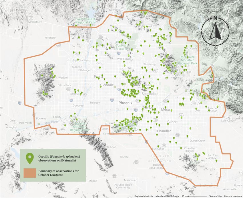
Land 2022, 11, 137                                                                                             2 of 17

                     and storms [9,10]. Climate change also impacts local communities, often in detrimental
                     ways [11,12].
                          In conjunction with natural forces, land managers must also plan for and mitigate
                     changes to habitats due to human usage, including activities considered consumptive
                     (such as resource extraction) and nonconsumptive (such as outdoor recreation) [2,7]. Of
                     particular interest to this study are those “nonconsumptive” activities that have increased
                     in their intensity consistently over time, for example, hiking, camping, OHV, shooting,
                     mountain biking, etc. This is taxing the natural infrastructure, impacting the health of the
                     landscape, and testing the innovation of land managers who are operating with limited
                     resources while trying to ensure the safety of users [13]. The growing intensity of use
                     is further complicated by changes in user behavior, influenced by traditional marketing,
                     social media, tourism trends, and global conditions (e.g., the COVID-19 pandemic) [14,15].

                     1.2. Demonstrated Negative Impacts of Social Media and Apps on Land Management and
                     Related Conservation
                           As with many aspects of modern life, social media and the use of phone applications
                     (henceforth, “apps”) has shaped the opportunities and challenges that land managers face
                     worldwide. Each may influence user behavior such that there is an increase in the intensity
                     of use in previously low-impact areas, degradation of sensitive habitats and archeological
                     sites, handling of wildlife and artifacts, and dangerous behaviors driven by online clout
                     culture and trends [16].
                           Among social media platforms, Instagram (iOS version 217.0; Android version 216.1.0.21.137;
                     Menlo Park, CA, USA) has received considerable attention in this regard, although all
                     platforms have the potential to cause similar issues depending on their level of popularity
                     at any one time [16,17]. Using Instagram as an example, social media can influence behavior
                     at scale by introducing large groups of people to landscapes previously unknown to them.
                     The patterns (both algorithmic and human) of popularity among posts and images of these
                     landscapes may drive some users to behave in ways perceived by them to receive more
                     attention on the platform [18].
                           The rapid increase in the popularity of places such as Horseshoe Bend, AZ, USA,
                     which has become an Instagram staple, has required infrastructural hardening of the site in
                     order to manage impacts of increased traffic [19]. Further, images with animals, showing
                     the account owner deeply immersed in the environment or depicting risky behavior, can
                     result in more popular posts. Some notorious results of this include the death of a dolphin
                     calf who was removed from the ocean by beachgoers and held for photographs for a
                     prolonged time [20] and the many images of recreational users approaching charismatic
                     wildlife such as bison [21]. Desire for depicted immersion also led to the degradation of the
                     California poppy super bloom in 2019 [22]. There is a growing rise in recreational users
                     who have damaged resources, and/or suffered injury and even death while posing for
                     photos in the hope of attracting interest on Instagram and other platforms [23,24].
                           Among apps not otherwise considered as social media platforms, AllTrails (iOS version
                     14.3.0; Android version 14.2.0; San Francisco, CA, USA) serves as an example of the impacts
                     these tools can have for land management. AllTrails is a popular crowd-sourced trail guide
                     and tracker with information on hiking, biking, and OHV trails all over the world. While
                     this is a powerful tool for users looking to explore and navigate via their phones, guides
                     and maps are created by users, which means that they may represent non-established trails
                     and can lack important safety, permitting, and access information. Users may be accessing
                     sensitive areas and/or circumventing planned trail networks, and/or continue to use areas
                     designated for rehabilitation or trail closure, due to these guides. Land managers may also
                     find an increase in the need for rescues due to misrepresentation of trail conditions [25].
                     These guides can be edited and removed by land managers, but AllTrails only represents
                     one of many such apps and the scale of the user-base-produced guides far outstrips that of
                     land management staff [26].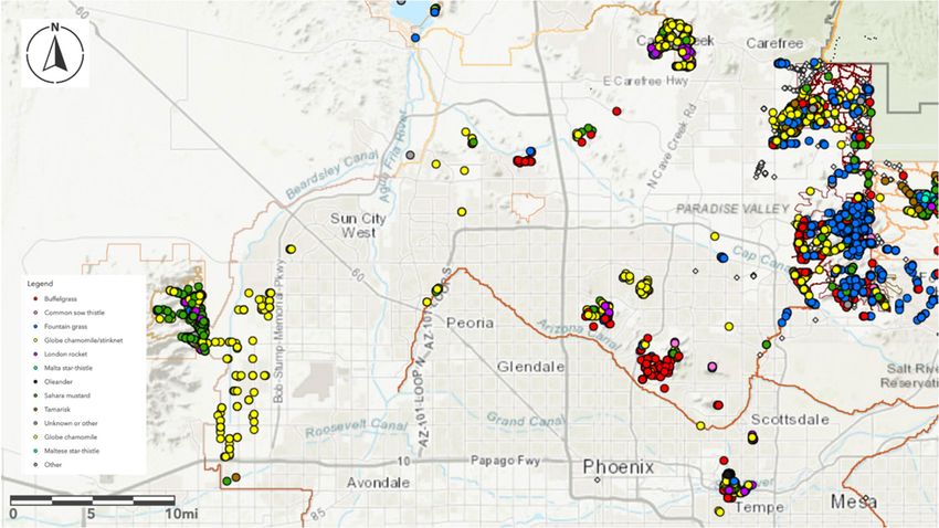
Land 2022, 11, 137                                                                                            3 of 17

                     1.3. Potential for Support of Land Management and Associated Community Well-Being by Social
                     Media and Other Apps
                           Although the challenges presented by social media and other apps require the atten-
                     tion of land managers, there are also positive potential applications of these online tools
                     including support for conservation activities via data collection, awareness raising for
                     policy changes and increased community support, and enhanced community resilience to
                     natural disasters related to climate change and biodiversity loss.
                           Land management and conservation have considerable and immediate data demands
                     for informed decision-making. However, there is a lack of time or resources to collect
                     sufficient information, and often actions must move forward with the available data [27,28].
                     Community science is one method to supplement and address data needs, as apps can serve
                     as a means for collecting, collating, and even analyzing data [29]. Some common examples
                     of apps that can support data gathering and community science include iNaturalist (iOS Ver-
                     sion 3.2.4; Android Version 1.25.12; San Francisco, CA, USA), ESRI’s (Redlands, CA, USA)
                     Field Maps (iOS Version 21.4.0; Android version 21.4.0), and EDDMapS (iOS Version 1.0.9;
                     Android version 1.1.8; Tifton, GA, USA), among others. Some of these will be explored in
                     the case studies below.
                           Social media platforms can be used to elevate land manager messaging and create a
                     sense of community between the public and land managers. This facilitated communication
                     and increased transparency has been found to ease tension around changing policy and
                     increasing cooperation [30]. The sense of community and avenues for free discussion via
                     social media can also support inclusion, outreach and education, can increase support
                     for ongoing land management activities, and increase public engagement surrounding
                     planning processes [31,32].
                           Finally, research on community resilience would suggest that when properly applied,
                     social media and other online technologies may be effective tools for supporting commu-
                     nities through natural disasters, such as those linked to climate change and biodiversity
                     loss [33,34]. Community resilience may be defined as (1) a system’s ability to return to a
                     particular state after perturbations (such as natural disasters) and/or (2) an individual’s
                     ability to recover from disturbances (such as natural disasters) [35]. Social capital, or the
                     sense of community and goodwill among members of a group, is understood to be closely
                     linked with community resilience such that best practice would dictate the consideration of
                     both infrastructural and social mitigation of disaster impacts [36]. Of the nine elements com-
                     monly associated with community resilience across the literature, social media and other
                     online apps are likely to support five, including: local knowledge, community networks
                     and relationships, communication, preparedness, and mental outlook [37].
                           It will be key for land managers to utilize digital tools to their benefit in this age of
                     rapid change and social-media-driven trends. Ambassadorships and community science
                     programs are two potential methods for harnessing the potential power of these digital
                     tools to support land governance.

                     1.4. Introduction to the Central Arizona Conservation Alliance
                          The Central Arizona Conservation Alliance (CAZCA) is an initiative of Desert Botan-
                     ical Garden (DBG), founded in 2012 out of Phoenix, Arizona, USA. The Alliance, as of
                     2021, consists of more than 60 partner organizations including parks and recreation de-
                     partments at city and county levels, land managing federal and state agencies, and local
                     nonprofits working on biodiversity conservation and community well-being, with DBG
                     as the backbone organization [38]. The objective of CAZCA is to facilitate collaborative
                     conservation efforts across the Central Arizona region, with a focus on Maricopa County
                     and its associated HUC 10 watersheds, in order to create a network of natural open spaces.
                     This network includes habitat blocks across the urban–rural gradient, as well as habitat
                     corridors of varying sizes, and integrates already existing parks and preserves with habitats
                     that are yet to be protected. These lands would serve as recreational areas for local residents
                     and visitors, while maintaining thriving Sonoran Desert ecosystems.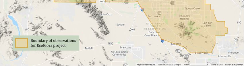
Land 2022, 11, 137                                                                                              4 of 17

                           CAZCA is designed to accomplish this by leveraging expertise and resources from or-
                     ganizations across the region and working towards the vision outlined above, as guided by
                     the collaboratively developed Regional Open Space Strategy for Maricopa County (ROSS).
                     The ROSS integrated leadership and feedback from more than 50 partner organizations
                     to outline objectives for four primary goals includes: (1) protect and connect ecosystems
                     across the region, (2) sustain and restore habitats protected in the present and future,
                     (3) create spaces for local champions to love and support the network of open spaces, and
                     (4) continue this work via the coordination and elevation of partner organizations and
                     their work [39].
                           Functionally, as a fairly young collaborative conservation initiative as per the collective
                     impact framework [38], CAZCA has and continues to accomplish many of its goals via
                     collaborative programs and projects. Many of these focus on collective strategy develop-
                     ment and decision-making, as well as on-the-ground conservation efforts such as invasive
                     plant management and native plant material development. However, CAZCA has also
                     innovated on land management issues through the use of social media (Sonoran Insiders)
                     and community science using smartphone apps (Desert Defenders and Metro Phoenix
                     EcoFlora, henceforth, EcoFlora).
                           It is our objective to utilize three case studies from among CAZCA’s programs, where
                     social media and smartphone apps have been successfully applied to land management
                     challenges and community resilience building, to illustrate the realized potential of digital
                     technologies and explore lessons learned and challenges faced.

                     2. Materials and Methods
                          We cover three different programs here to explore the role of social media and online
                     technologies in supporting land governance in the arid southwestern USA (Table 1). All of
                     these programs are collaborative in nature and focus on regions of varying sizes in Central
                     Arizona. This general spatial focus is determined by the study area of CAZCA, which is
                     defined by the location of our institution, Desert Botanical Garden in Phoenix, AZ, USA,
                     and the Regional Open Space Strategy for Maricopa County.

                     Table 1. CAZCA programs explored in this case study in order of examination.

                       Program Name           Focal Area            General Objectives         Technology Utilized
                                                                 Public education on land
                                           Central Arizona,
                       Sonoran Insiders                        management, policy changes,          Instagram
                                                USA
                                                                   and responsible use.
                                                                Map and monitor invasive
                                                                                                 ESRI Field Maps,
                                           Maricopa County,         plant species; share
                      Desert Defenders                                                            ESRI Collector,
                                            Arizona, USA              information on
                                                                                                  ArcGIS Online
                                                                  management strategies.
                                                                Collect, analyze, and share
                                               Phoenix                                          iNaturalist, SEINet,
                                                               urban biodiversity data and
                        Metro Phoenix       Metropolitan                                            Instagram,
                                                                 information; increase the
                          EcoFlora          Area, Arizona,                                       Facebook, Twitter,
                                                                    understanding and
                                                USA                                                   Zoom
                                                                appreciation of plant life.

                     2.1. Sonoran Insiders’ Programmatic Methodology
                          The Sonoran Insiders program seeks to create a community with local social media
                     influencers to elevate messages about responsible use and raise awareness of the work
                     performed by organizations to protect and maintain natural areas. The successes and
                     lessons learned from this work illustrate the power and potential for social media to
                     support land governance. It is a collaborative effort that includes leadership from CAZCA,
                     the National Forest Foundation, and the Tonto National Forest as of 2019–2021.
                          The primary social media platform of focus for this program was Instagram. This
                     platform was selected due to its historic impact on public lands and natural open spaces
                     globally [14,17]. Furthermore, it remains one of the most popular social media platforms,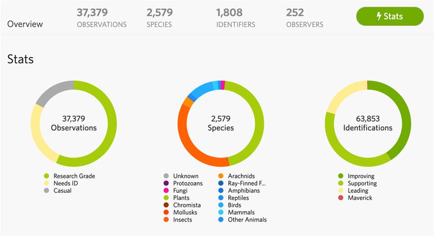
Land 2022, 11, 137                                                                                            5 of 17

                     with roughly one billion users monthly in 2021 [40]. Instagram also strikes an impactful
                     balance between visual and written storytelling in a way that facilitates strong messaging
                     opportunities more suited to the needs of awareness-raising than Twitter (which previous
                     to 2021, edited image display sizes automatically and limited the characters of a single post)
                     or Facebook (which has severely cut its users’ organic reach in recent years).
                           The Sonoran Insider social media ambassadors, or influencers that participate in the
                     program, were initially identified based on their location, follower counts, and the quality
                     of content in their Instagram feed. Local ambassadors self-selected, but no spatial boundary
                     was drawn for the project. The collaborative agreement with the ambassadors included
                     requirements for participation in in-person events, such that the participants themselves
                     could determine if they were close enough to attend regularly.
                           In terms of follower numbers, we determined that influencers with 800+ followers
                     would be ideal for our project needs and the resources available for the project. Our team’s
                     expert experience in the field indicated that this number would provide a robust minimum
                     follower count and would avoid excluding most passionate ambassadors with smaller
                     audiences. Furthermore, larger influencers often require payment for partnerships with
                     them and we did not have such funds. We also prioritized the quality of influencer con-
                     tent in regards to responsible recreation practices and stewardship. We initially recruited
                     local influencers who already demonstrated some interest in the outdoors or the envi-
                     ronment through the use of local outdoor recreation hashtags such as #hikearizona and
                     #explorearizona.
                           Ambassadors were then recruited through targeted digital outreach, either via direct
                     messages on Instagram or via email. Upon joining, they signed a non-formal agreement to
                     attend at least five events per year, create two to four posts on the events and another two
                     to four posts about related themes such as Leave No Trace, wildfire prevention, invasive
                     plant species management, etc. To assist the ambassadors with the sharing of key messages,
                     we developed briefs that succinctly summarized the theme, messages, and calls to action.
                     These include relevant hashtags, links, and sample text.
                           Some examples of responsible-use messages elevated by the program include: (1)
                     methods for preventing human-caused wildfire and (2) exploration of the damage that
                     off-trail recreation can have on microbiomes and non-charismatic species such as desert
                     biocrusts. With the large increase in usage of public lands throughout 2020 due to COVID-
                     19 impacts [41], ensuring these messages are reaching both new and long-term users is
                     a key to lessening the impact of recreation on habitats and infrastructure. This is being
                     accomplished at a scale that would not be within the budgets of many land managers [42].

                     2.2. Desert Defenders’ Programmatic Methodology
                           There are a variety of invasive plant species (including buffelgrass (Cenchrus ciliaris),
                     fountain grass (Cenchrus setaceus), and stinknet (Oncosiphon piluliferum)) that are known to
                     threaten both local community well-being and the habitats of the Sonoran Desert. Some
                     outcompete native species for habitat and resources and impact the ecosystem services of
                     Central Arizona, while many vastly increase wildfire fuel loads which has led to larger, more
                     commonly occurring fires [43–45]. As these species are present across land jurisdictions
                     and at a large and rapidly changing scale, effective management requires cooperation and
                     sufficient data on where these species are, how their ranges change over time, and the
                     success of treatment efforts.
                           Except in a few cases, land managers in this region lack the resources to accomplish
                     all of this. CAZCA, with McDowell Sonoran Conservancy, Maricopa County Parks and
                     Rec, White Tank Mountains Conservancy, Friends of the Tonto, the City of Phoenix Parks
                     and Rec, the City of Tempe Parks and Rec, and Arizona Sustainability Alliance, set out
                     to address this challenge via technology-supported community science in a project called
                     Desert Defenders (DD).
                           The collaborative team has been utilizing ESRI’s Collector and Field Maps smartphone
                     apps to gather data annually on the presence of eight focal invasive plant species. With the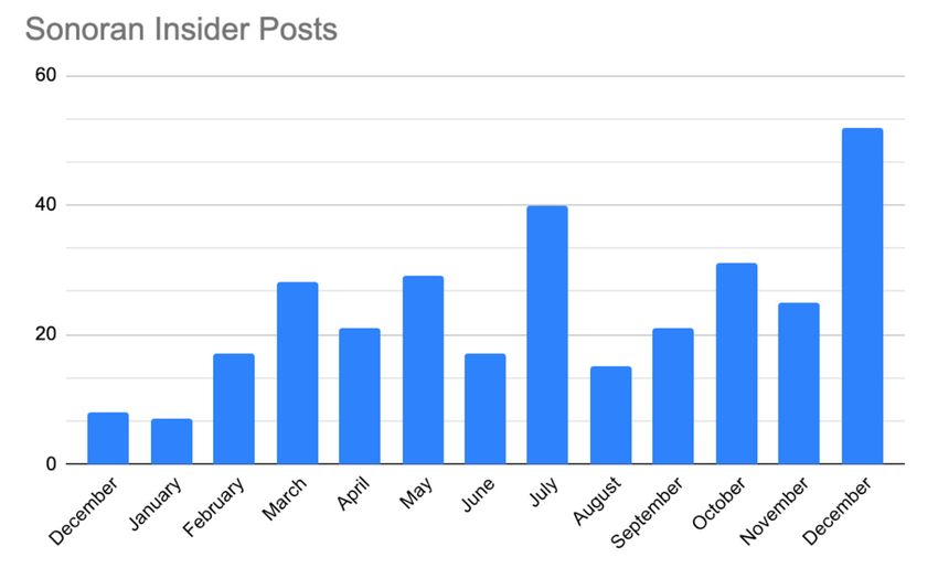
Land 2022, 11, 137 6 of 17
support of these apps, the professional team trains volunteer, community scientists how to
identify the focal species and how to add data points on the regional map demarcating the
location of the plants to best support local land managers each year. The process of adding
data to the map is simple; community scientists download the ESRI Collector or Field
Maps app onto their smartphone after they are trained to identify the focal invasive plant
species. They then travel into the field, and use their smartphones and FieldMaps/Collector
to mark GIS points in real time with data about the plant species found, what stage of
life those plants are at, how many there are, and whether that area has been treated to
manage invasive plants previously. Mapping activities can be initiated quickly and adapted
to changing conditions, e.g., wildfires, early or particularly strong monsoons prompting
invasive plant growth. The same apps are then utilized to track and monitor treatments by
drawing polygons around those areas and can help determine best re-treatment approaches.
2.3. EcoFlora Programmatic Methodology
The EcoFlora project leverages community science to collect data on urban biodiver-
sity, specifically plant life, and enhances community relationships with nature through
technology, engagement, and communication. The project focuses on understanding the
impacts of urbanization, accessible biodiversity data, and increasing the understanding
and appreciation of plant life. By connecting with the community, contributing to local
conservation efforts, and studying urban biodiversity, the project contributes to building
community resilience.
EcoFlora is a collaborative project initiated by the New York Botanical Garden in
2016. In 2019, a National Leadership Grant from the Institute of Museum and Library
Services was awarded to the New York Botanical Garden and partner gardens to expand
the EcoFlora model across the United States. The partner garden recipients include the
Chicago Botanic Garden, Denver Botanic Gardens, Desert Botanical Garden, and Marie
Selby Botanical Gardens. Within the Desert Botanical Garden, the CAZCA team operates
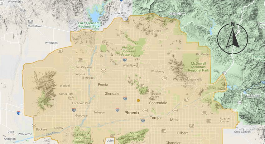
EcoFlora in the Phoenix metropolitan area (Figure 1).
The project collects data on urban biodiversity through iNaturalist (https://www.
inaturalist.org/ (accessed on 11 January 2022)), a free web-based platform and app that is a
joint initiative of the California Academy of Sciences and the National Geographic Society.
Project members create observations with the mobile phone app, or upload images taken
with a camera to the website. Photos can be coupled with suggested identifications, various
annotations, and observation fields such as life stage, phenology, and associated organisms.
iNaturalist neatly houses projects and observation data on their servers for free. This data
is downloadable and open source, making it more accessible and useful for conservation
efforts, land managers, and organizations. EcoFlora compares data from iNaturalist with
the legacy data from the Southwestern Environmental Information Network (SEINet)
( https://swbiodiversity.org/ (accessed on 11 January 2022)), a digital portal for floristic
information that provides open access to floras, herbarium data, and collections. Species
lists have been created with this comparison data and will provide preliminary information
about plant biodiversity changes in the Phoenix metropolitan area over time.
EcoQuests are monthly challenges in addition to the overall project that ask members to
observe specific species or ecological interactions. This is a venue for collecting specific data
and information, and for collaboration. Working with community scientists, EcoFlora can
provide supplemental data and support for other projects, organizations, and municipalities.
One example is the project collaborated with the Great Milkweed Grow Out (GMGO)
program at the Desert Botanical Garden to supplement data concerning western monarch
butterfly decline. The EcoFlora model can also be implemented and utilized by other
organizations; the Maricopa County Parks and Recreation Department modeled their
EcoBlitz program after EcoFlora.Land 2022,
Land 11, x137
2022, 11, FOR PEER REVIEW 7 7ofof 19
17
Figure 1. EcoFlora project boundary created with iNaturalist, using Google Maps data.
Figure 1. EcoFlora project boundary created with iNaturalist, using Google Maps data.
The projectis the
Engagement collects
gateway data on urban
to involvement and biodiversity throughWithout
success in the project. iNaturalist
an en-
(https://www.inaturalist.org/ (accessed on 11 January 2022)), a free
gaged group of community scientists, the project would not be able to gather sufficientweb-based platform
data
and app that
or increase is a joint initiative
community knowledge of the California Academy
of biodiversity and plantoflife.Sciences and the National
The iNaturalist website
Geographic Society.
includes a direct Project members
messaging feature, andcreate
thisobservations
was extremely with the mobile
helpful in the phone app, or
early stages of
upload images taken with a camera to the website. Photos can be coupled
the project to reach users already invested in using iNaturalist in the Phoenix metropolitan with suggested
identifications, various annotations,
area. Further engagement and observation
has been garnered fields
with video such as lifesoftware
conferencing stage, phenology,
and apps,
and
such as Zoom (San Jose, CA, USA) and Google Hangouts, developed by Googleon
associated organisms. iNaturalist neatly houses projects and observation data their
(Moun-
servers for free. This data is downloadable and open source, making
tain View, CA, USA), which allow the project to host virtual events and information and it more accessible
and useful
training for conservation
sessions. efforts, land
This was essential whenmanagers,
gatheringand
in organizations.
person was notEcoFlora compares
feasible due to the
data from iNaturalist with the legacy data from the Southwestern
COVID-19 pandemic. In-person engagement has included bird watching, moth lighting, Environmental Infor-
mation Network
and various (SEINet)( https://swbiodiversity.org/
botany-themed events. Through a monthly (accessed
e-newsletter on and
11 January 2022)),
social media and a
digital portal
associated for floristic
apps, information
the project has beenthatableprovides openengagement
to maintain access to floras,and herbarium data,
communication
and
withcollections. Speciesthem
members, inform lists of
have beendevelopments,
project created with this
andcomparison data and will
provide opportunities to provide
increase
preliminary information about plant biodiversity changes in the Phoenix
their environmental literacy and plant appreciation. Social media specifically has provided metropolitan
area over time. to communicate and engage with a wider audience.
the opportunity
EcoQuests are monthly challenges in addition to the overall project that ask members
3. observe
to Results specific species or ecological interactions. This is a venue for collecting specific
data and
The information,
quantitative and formedia
social collaboration. Working with community
and data-production results for eachscientists,
projectEcoFlora
will be
can provide supplemental
represented in this section,dataalong and support
with for other
qualitative projects,
outcomes fororganizations,
the congruityand munic-
of our case
ipalities. One example is the project collaborated with the Great Milkweed Grow Out
study explorations.
(GMGO) program at the Desert Botanical Garden to supplement data concerning western
3.1. Sonoran
monarch Insidersdecline. The EcoFlora model can also be implemented and utilized by
butterfly
otherOver the coursethe
organizations; of Y1, the number
Maricopa Countyof Insider posts
Parks and increasedDepartment
Recreation as the community
modeled of
ambassadors
their EcoBlitz grew andafter
program the program
EcoFlora.engaged more with the participants through events,The quantitative social media and data-production results for each project w
represented in this section, along with qualitative outcomes for the congruity of ou
study explorations.
Land 2022, 11, 137 3.1. Sonoran Insiders 8 of 17
Over the course of Y1, the number of Insider posts increased as the commun
ambassadors grew and the program engaged more with the participants through e
online
online discussions, discussions,
and andcollaborations
social media social media collaborations
(e.g., Instagram(e.g., Instagram
take-over and take-over
Insider- and In
led hiking webinar). This trend culminated in the largest number
led hiking webinar). This trend culminated in the largest number of posts in December of posts in Dece
2020 (n =
2020 (n = 52; Figure 2). 52; Figure 2).
Figure 2. Number of posts
Figure on Instagram
2. Number with
of posts onthe hashtag #sonoraninsiders
Instagram by month, from December
with the hashtag #sonoraninsiders by month, from D
2019–Decemberber
2020.
2019–December 2020.
The impacts ofTheambassador
impacts ofposts were measured
ambassador via their
posts were reachvia
measured on their
Instagram. TheInstagram
reach on
term “reach” here refers to the number of unique users that saw the Instagram post using
term “reach” here refers to the number of unique users that saw the Instagram post
the #sonoraninsiders hashtag on anyhashtag
the #sonoraninsiders given day.
on This number
any given was
day. calculated
This numberbywas
adding all
calculated by a
of the followers of each account that engaged with the post using the hashtag. The Sonoran
all of the followers of each account that engaged with the post using the hashtag
Insiders hashtag was used 311 times during year one, accumulating 57,059 likes. We had
an annual reach of 5,996,329 people and an average monthly reach of 935,641 people. For
reference, the estimated cost of reaching 6 million people with an online ad campaign
could range from $18,000 to $60,000, with an average cost per thousand impressions of
$3–$10 across the main advertisement platforms [46]. Due to the focused nature of our
ambassador audiences, it is possible that the value of this outreach is underestimated, as
the posts produced are organically targeting relevant audiences to land managers.
Support for conservation is produced in two ways through this program: (1) by
elevating responsible-use behaviors to help protect sensitive environmental and cultural
elements of the landscape and (2) raising awareness for volunteer opportunities and
charitable support of conservation programs and events. Themes communicated through
this social media outreach are shaped by the leading collaborators of the Sonoran Insiders
program, in conjunction with other land-managing partners involved in the monthly events
on which messaging is based. For example, in early 2020, the program partnered with
the McDowell Sonoran Conservancy (MSC) for a behind-the-scenes tour of ecological and
restoration research run in the McDowell Mountains Preserve. MSC then led the crafting of
the brief, as well as the narrative and calls-to-action presented at the event itself.
3.2. Desert Defenders
The Desert Defenders community science mapping activities have been active from
December 2018 to July 2021, with increasing participation from local land managers over
time. This has produced a regional map (Figure 3) of the focal invasive species from
lands managed by Maricopa County Parks and Recreation, and the City of Scottsdale,
City of Tempe, and City of Phoenix parks and recreation departments. This map includes3.2. Desert Defenders
The Desert Defenders community science mapping activities have been active from
December 2018 to July 2021, with increasing participation from local land managers over
time.
Land 2022, 11, 137 This has produced a regional map (Figure 3) of the focal invasive species from lands 9 of 17
managed by Maricopa County Parks and Recreation, and the City of Scottsdale, City of
Tempe, and City of Phoenix parks and recreation departments. This map includes 6824
observations from6824
moreobservations from more than
than 100 community 100 community
scientists. Table 2scientists. Table
illustrates the2number
illustratesofthe number
of data points for each of the focal invasive
data points for each of the focal invasive plant species. plant species.
Figure 3. Example map for Desert Defenders; colored points represent different species of focal in-
Figure 3. Example map for Desert Defenders; colored points represent different species of focal
vasive plants identified across the region as of Spring 2021.
invasive plants identified across the region as of Spring 2021.
Table 2. Focal invasive plant species and number of data points for each produced by community
scientists from 2018–2021.
Species Name (Common) Number of Data Points
Buffelgrass 659
Common sow thistle 66
Fountain grass 1788
Globe chamomile 1704
London rocket 600
Maltese star-thistle 159
Oleander 38
Sahara mustard 1130
Tamarisk 137
Unknown or other 251
There are several key impacts from this project. First, the data gathered by community
scientists through the apps has given land managers access to annual spatial data on
invasive plant species across the landscape (Table 2). In 2021, thanks to these efforts, a
regional map was created, with minimal monetary investment from land managers outside
of the modest staff time and the ESRI licenses necessary for volunteers to use the app. This
cost could be further limited through the use of free apps such as EDDMapS, launched and
maintained by the University of Georgia. In any case, this data allows for annual planning
for treatments that make the most efficient use of limited resources. It has also provided
information for the movement of invasive plant species across the region, facilitating
collaboration and management among land managers across jurisdictions.Land 2022, 11, 137 10 of 17
3.3. EcoFlora
Key impacts from the project include open-access biodiversity data, alleviating plant
invisibility and increasing support for conservation, and community resilience through
involvement in community science. As mentioned above, iNaturalist and SEINet are both
open-access platforms, making the data and collections gathered through EcoFlora available
to anyone interested in viewing or using them. The project began in February 2020 and
as of December 2021, 361 people have become project members and 37,319 observations
(21,175 plants) of 2577 species (1158 plant species) have been made by 252 observers, with
1802 identifiers (https://www.inaturalist.org/projects/metro-phoenix-ecoflora, accessed
on 14 December 2021) (Figure 4). iNaturalist observations have provided a wealth of open-
Land 2022, 11, x FOR PEER REVIEWsource data, which would otherwise be extremely difficult to achieve without an abundance
11 of 19
of community scientists.
Figure4.4.Screenshot
Figure Screenshot from
from EcoFlora
EcoFlora project
project page
page on iNaturalist
on iNaturalist website
website showing
showing current
current projectproject
stats.
stats.
People and communities can directly participate in EcoFlora in a way that is not
People or
intimidating and communities overwhelming.
technologically can directly participate in EcoFlora
Project members canin a way
make that is not in
observations in-
their own neighborhoods, in a place they have local knowledge of, and can connect theirin
timidating or technologically overwhelming. Project members can make observations
their experience
lived own neighborhoods,
with. Theyinunderstand
a place theytheir
haveneeds,
local knowledge
wants, and of, and can connect
challenges, and feeltheir
the
lived experience
ramifications with.and
of policy They understand
daily their than
changes better needs, wants,
those anddo.
outside challenges,
They are andmorefeel the
likely
toramifications
notice a newofplantpolicy and daily
species changes better
or understand where than
streetthose
trees outside do. They
that provide shadeare more
would
belikely
mosttovaluable.
notice a Through
new plantiNaturalist,
species or project
understand where
members street
can trees
use the that provide
species shade
information,
would be most
observation valuable.
images, and mapsThrough iNaturalist,
to support project members
conservation can use the
and intersectional species infor-
environmental
efforts
mation, in observation
their community.images,Forand
the maps
EcoQuest in October
to support 2020, project
conservation andmembers observed
intersectional envi-
624 ocotillo efforts
ronmental plants in
(Fouquieria splendens),
their community. bringing
For the total
the EcoQuest in number
October of observations
2020, in the
project members
Phoenix
observed metropolitan
624 ocotillo area to (Fouquieria
plants 1056. With splendens),
this observation
bringingdata,
thecommunity
total number members can
of observa-
see possible
tions in thecorridors
Phoenixfor pollinators and
metropolitan areawildlife
to 1056.that connect
With to open spacedata,
this observation (Figure 5). This
community
can be usedcan
members bysee
thepossible
community to advocate
corridors for connectivity
for pollinators corridors,
and wildlife in turn to
that connect contributing
open space
to(Figure
landscape management efforts and community well-being through
5). This can be used by the community to advocate for connectivity corridors, increased nearby in
nature in urban areas [47]. Project members can communicate and
turn contributing to landscape management efforts and community well-being throughbuild relationships with
one anothernearby
increased through interaction
nature in urban onareas
the iNaturalist platform
[47]. Project members andcanthecommunicate
project’s socialandmedia
build
accounts. These
relationships venues
with allow people
one another throughto actively takeon
interaction part
theiniNaturalist
community conversations
platform and the
about urban
project’s biodiversity.
social media accounts. These venues allow people to actively take part in com-
munity conversations about urban biodiversity.Land 2022, 11, 137 11 of 17
Land 2022, 11, x FOR PEER REVIEW 12 of 19
Figure5.5.iNaturalist
Figure iNaturalist map
map showing
showing observations
observations of ocotillo
of ocotillo (Fouquieria
(Fouquieria splendens)
splendens) and and possible
possible con-
connec-
nectivity corridors in the Phoenix metropolitan area, accessed on January 5, 2021.
tivity corridors in the Phoenix metropolitan area, accessed on 5 January 2021.
Eventshosted
Events hostedby byEcoFlora
EcoFloragive givepeople
peoplethe theopportunity
opportunitytotoconnect
connectwithwithscientists,
scientists,
local leaders, organizations, and professionals. EcoQuestions,
local leaders, organizations, and professionals. EcoQuestions, for example, are virtualfor example, are virtual
questionand
question andanswer
answersessions
sessionsthatthatprovide
providethe theopportunity
opportunityfor forproject
projectmembers
membersand andthe
the
communityatatlarge
community largetotolearn
learnmore
moreabout
abouturban
urbanbiodiversity
biodiversityand andplant
plantscience.
science.InIntotal,
total,
projectevents
project events and
and training
training sessions
sessions havehave
beenbeen attended
attended approximately
approximately 270 times,
270 times, with with
the
the project having 1081 followers collectively on Facebook, Instagram,
project having 1081 followers collectively on Facebook, Instagram, and Twitter. Increased and Twitter. In-
creased support for conservation ideally follows increased awareness
support for conservation ideally follows increased awareness and understanding of plant and understanding
of and
life plant life and biodiversity.
biodiversity. Collaborations,
Collaborations, events, andevents, and social
social media media
presence presence
equate to theequate
publicto
the public
learning more learning more about
about plants plants and biodiversity,
and biodiversity, alleviating
alleviating plant plant
invisibility invisibilityplant
(previously (pre-
viously plant
blindness), or theblindness),
tendency for or the tendency
people for people
to overlook plantsto overlook
and view themplants
withand view
lower them
regard
withother
than lower liferegard
formsthan[48].other life forms [48].
EcoFlora
EcoFlorahas hasa apositive
positiveimpact
impacton onthe
themental
mentalandandphysical
physicalhealth
healthofofthe
thecommunity
community
through
throughencouraging
encouragingphysical physicalactivity
activityandandproviding
providingmental
mentalstimulation.
stimulation.Project
Projectmem-
mem-
bers
bershave
haverepeatedly
repeatedlystated statedthatthatEcoFlora
EcoFlorahas hasprovided
providedthemthemwith
withananoutlet,
outlet,specifically
specifically
throughout
throughoutthe theCOVID-19
COVID-19pandemic.pandemic.Making
Makingobservations
observationscan canbebedone
donealonealoneororwhen
when
socially
sociallydistanced,
distanced,and andisisananactivity
activitythat
thatcan
cansafely
safelybebedone
doneoutdoors.
outdoors.EcoQuest
EcoQuestchallenges
challenges
also
alsogive
giveproject
project members
members something
something newnew to look forward
to look to every
forward month,
to every month,contributing to
contributing
well-being through anticipation of future positive
to well-being through anticipation of future positive events [49].events [49].
4.4.Discussion
Discussion
InInregards
regardstotoland
landgovernance,
governance,social
socialmedia
mediaand
andother
otheronline
onlineapplications
applicationsare
areoften
often
posed as challenges. For example, clout-chasing may cause users to engage in behaviors
posed as challenges. For example, clout-chasing may cause users to engage in behaviors
that risk their safety or the natural resources themselves [23,24]. These tools can cause
that risk their safety or the natural resources themselves [23,24]. These tools can cause
rapid increases in area use over a relatively short period of time, making management
rapid increases in area use over a relatively short period of time, making management and
and infrastructure development a game of catch-up [19]. With limited resources, both in
infrastructure development a game of catch-up [19]. With limited resources, both in terms
terms of monetary support and staff capacity, land governance may be faced with resulting
of monetary support and staff capacity, land governance may be faced with resulting
changes that damage resources, degrade trust, and create new use-norms that undermine
changes that damage resources, degrade trust, and create new use-norms that undermine
conservation efforts.
conservation efforts.Land 2022, 11, 137 12 of 17
These are all serious concerns. However, much of the evidence for such impacts is
rhetorical, with increasing calls for closer studies of these impacts, to understand when they
manifest and how [32]. At the same time, there are large potential benefits for both users
and land managers that include increased equity of access and much-needed social support
for land governance activities. As we will demonstrate below, our models specifically
demonstrate the positive benefits of social media and other online applications (such as
iNaturalist and ESRI Field Maps) in regards to support for (1) biodiversity conservation,
(2) land governance and policy changes, and (3) building community resilience.
4.1. Sonoran Insiders
The Sonoran Insiders program contributes to community resilience in a variety of
ways in the face of disasters such as those caused by climate change and biodiversity
loss. In particular, when considering the common elements of community resilience as
identified by Patel et.al. in their 2017 systematic review [37] of the concept, four common
elements are positively impacted by this application of social media to land governance.
(1) Social media through the Insiders program has increased local knowledge around
land management, related disasters, and modes for community involvement in protecting
natural resources and local infrastructure from disasters. (2) The Insiders program builds
community networks and relationships between land managers and the public. (3) It
increases communication between and among land managers, program ambassadors,
nonprofit partners, and the public. (4) Through all of this, messaging and connections
formed through the project have the potential to increase hope among community members
and, thus, improve mental outlooks.
There is considerable need for volunteer support for land management activities
ranging from infrastructure maintenance to ecological research. Volunteers can be difficult
to recruit, and the costs for finding a sufficient volunteer force can include marketing costs,
as well as the time and capacity of volunteer coordinators (where available) [50]. Thus,
alleviating those needs through effective social media messaging can represent another
economic and social support for land managers.
Social media ambassadors and related social media communications have also pro-
vided support for land managers in cases of contested policy changes. For example, in 2021,
the City of Phoenix city council voted to institute trail closures during extreme heat days.
This decision was made following an increase in the number of rescues on the popular and
difficult Echo Canyon and Piestewa Summit trails, with the associated health impacts on
rescue personnel. While the rationale for these trail closures was logical and promoted
safety among both trail users and city staff, there was considerable pushback from some
sectors of the public to these closures [51]. A lack of cooperation with safety measures and
other land management policies can undermine safety and create resource sinks. Thus,
effective communication with trail-use communities is essential, in this case, among both
local users and tourists. Social media platforms, particularly those run by local influencers,
have the potential to reach both groups. Furthermore, communication from other users, as
opposed to perceived authority figures, can enhance the acceptance of new rules and use
patterns [52].
While this program has seen a variety of high-impact successes, even while at a pilot
stage, there are challenges to be accounted for when considering the social media am-
bassadorship model. First, while monetary investments are low compared to equivalent
marketing expenses, staff time may be considerable. Consistent engagement among am-
bassadors and between ambassadors and program staff is also essential for trust building.
This also requires a significant time investment by staff. For CAZCA’s program, this was
mitigated through collaboration among several organizations, which allowed for sharing
of the planning, organizational, and community-building duties.Land 2022, 11, 137 13 of 17
4.2. Desert Defenders
In conjunction with the raw data provided, the DD program bolsters land managers in
a variety of social ways. The training modules designed by the collaborative group include
extensive knowledge on the role of invasive plants in ecosystem shifts and increases in
wildfire risk for the community scientists. Thus, through involvement in the program,
members of the public gain hands-on conservation experience and have become advocates
and supporters for management efforts. In some cases, these community scientists have led
the mapping projects themselves in support of small municipalities, reached out to their
home owners associations (HOAs) about invasive plants in local landscapes, and raised
money to purchase equipment for invasive plant management efforts [29].
The data produced by the project also supports community resilience, particularly in
regards to pressing wildfire threats in the southwest. In particular, this data is essential for
the effective management of these invasive plant species such that the community and the
surrounding habitats can be protected from heightened wildfire risk and biodiversity loss.
Furthermore, this data supports preparedness in the community and can be used to identify
areas with high wildfire fuel loads. The process used to develop this data, via its reliance
on more than 100 community scientists across the region, also increases local knowledge on
the focal invasive plant species and their impacts on wildfire risk. Community scientists are
also provided with increased community networks and relationships with land managers
and scientists.
There are challenges to applying these ESRI apps to land management, however,
particularly in cases of limited expert capacity and volunteer coordination. While ESRI’s
GIS tools have powerful analytical capabilities, they are complex and require professional
levels of expertise to take full advantage of their functionality. In the case of this collabo-
rative community science project, the lack of a dedicated GIS professional has hampered
comprehensive use of the data gathered. Land managers utilizing similar community
science models would likely see more returns if a GIS manager can assist with the program.
Similarly, skilled volunteer coordination is an essential element of a successful community
science program, even with the support of powerful, user-friendly apps. Collaborators
with the Desert Defenders project have seen the most success mapping in cases of: (1) a
dedicated and highly trained force of stewards, (2) community scientists led by rangers on
joint mapping and removal efforts, and (3) single “champion” volunteers or interns who
take the lead in smaller areas.
4.3. EcoFlora
Of the aforementioned nine core elements most often associated with community
resilience, community science innately contributes to community resilience most strongly
through local knowledge, community networks and relationships, communication, health,
governance and leadership, resources, and mental outlook [37]. Community science
projects can become community networks, providing the opportunity for people to develop
relationships with one another that they may not have had otherwise, promoting social
capital, enhancing social cohesion and community trust, and contributing to community
resilience [36]. The data, information, and workload contributed by community scientists
can be used to shape policy or empower community involvement in local government and
leadership, and is at a wider range and frequency than could be accomplished by scientists
or land managers alone [53].
Community science can contribute to conservation by directly affecting the conser-
vation science influencing decision-making [54]. As mentioned previously, the project
collects a wealth of open-source data and information that can be used by the community,
organizations, or land managers. Educational resources, training sessions, and workshops
through the project give the community access to and experience with technological and
physical tools that exist indefinitely. Empowered with and given access to science knowl-
edge, tools, and experience, communities can be more involved in decision-making and
political advocacy, and feel more confident in conservation participation and activitiesLand 2022, 11, 137 14 of 17
surrounding urban biodiversity. This contributes to collective and self-efficacy, as well as
mental outlook, by providing people with a way to be directly involved in science and be
better prepared to respond to disasters such as wildfires. By making contributions that
help scientists understand more about urban biodiversity, gaining science knowledge and
experience, and contributing to local conservation efforts, EcoFlora project members are
building community resilience.
The EcoFlora project has not been without challenges, namely data quality, study area
considerations, and sustaining and growing engagement. Data quality can be lacking on
the iNaturalist platform. Observations by community scientists can be of poor quality, for
example, uploading out-of-focus images or cut flowers in a bouquet. The identification
feature of the iNaturalist platform does not require any kind of credentials. This can lead
to users making identifications at an exponential rate, simply to increase the number of
observations they have identified or to appear more knowledgeable. Other users can
make incorrect identifications simply because they are trying to learn and become better
at identifying organisms. To alleviate the data-quality challenge, the EcoFlora project has
created collateral to guide project members in making quality observations and has asked
local experts to assist in monitoring identification accuracy.
When deciding on the study area for EcoFlora, there were multiple factors to consider.
The Phoenix metropolitan area is a large and rapidly increasing region that does not
have a defined boundary. It consists of numerous cities and towns and has a variety of
land uses. Distinguishing urban, suburban, and exurban areas for the boundary was not
feasible, while previously created Keyhole Markup Language (KML) files did not exist.
Highways and roads can provide clean lines for a boundary, but they can inequitably divide
communities and create border vacuums [55]. In creating a study area, EcoFlora sought
to include the multiple parks that surround the Valley, be considerate of tribal lands, and
not exclude under-resourced communities. A hand-drawn boundary in iNaturalist was
created, using the CAZCA study area as a base and keeping these elements and objectives
in mind.
Initiating and sustaining engagement is a struggle that many smaller conservation
organizations face. EcoFlora is fortunate to have the backing and support of CAZCA,
DBG, and the EcoFlora partner gardens. Without this existing support, it would have been
substantially more difficult to make the public aware of the project. Even with this support,
engaging the community and drawing participants to the project has been challenging,
specifically considering the COVID-19 pandemic. It was not possible to host in-person
workshops and events that could increase interest and participation in the project with
large groups of people. Engagement has been largely virtual, which has presented its own
learning curve. When feasible, in-person events with limited attendance (10 or less people)
while following pandemic guidelines have resulted in fluctuating attendance. Without
the digital distribution of EcoFlora information through iNaturalist, DBG, and CAZCA,
along with online technologies such as video conferencing software, social media, and
e-newsletter, the project would not have been able to initiate or sustain the engagement
that it has.
5. Conclusions
Social media has often been considered a source of increasing challenges to land
management of public lands and natural open spaces worldwide, but these tools also
have supportive potential which is of considerable importance as natural disasters increase
with climate change and resource shortfalls for land managers become more common.
Our three case study programs illustrate a variety of ways that land managers can use
social media and other online applications (iNaturalist and ESRI FieldMaps) to enhance
governance and local well-being. We have demonstrated that each model provides support
for (1) conservation activities, (2) land governance and policy changes, and (3) community
resilience. In conjunction with this, two of the projects also provided spatial data relevantLand 2022, 11, 137 15 of 17
for land management via community science efforts that utilized online applications as
user-friendly data-gathering interfaces.
While capacity and expertise are necessary to launch ambassadorships and community
science, programs that make the best use of social media and online technologies ensure
resources can be kept to a minimum. Innovation and the potential for such efforts to
alleviate landscape governance and land management resource challenges is considerable.
The case studies outlined lend practical support for the application of different kinds of
online technologies to the challenges faced by land managers, and also outline models
for applying these tools in effective ways. They are shown to provide marketing and
outreach that might otherwise be cost prohibitive, while also building relationships and
trust between land managers, partner organizations, and the public [16,42,46]. Data on
changing conditions is also essential to effective landscape-scale governance and biodi-
versity conservation efforts, but the temporal and spatial extent of that need can also be
prohibitive without community support. Online technologies, particularly phone apps,
can facilitate the creation of community science projects that can supply data, while also
developing public support and understanding for land managers [28,29].
In conjunction with the various ways in which programs linked with social media and
online technologies support land managers directly, these efforts can enhance community
resilience to unprecedented changes in the environment and disasters such as wildfires,
hurricanes, and pandemics, among others. In particular, of the elements commonly identi-
fied across fields as elements of community resilience [37], those that have been found to
be positively influenced by these efforts include local knowledge, community networks
and relationships, communication, resources, preparedness, and mental outlook. The
impacts of social media and app-supported efforts by land managers could be further
improved through design and planning that explicitly targets community resilience as a
primary objective.
Finally, the challenges outlined in these case studies, as well as the moderate resource
needs of these models, can be sourced via collaborative efforts among organizations with
common goals. While complex, collaborative efforts facilitate the leveraging of limited but
shared resources for the greater good and also enhance the effectiveness of land governance
among varied assemblages of stakeholders and constituents [56,57].
Author Contributions: Conceptualization, A.B.R., A.Q. and J.D.; Methodology, A.B.R., A.Q. and
J.D.; Software, A.B.R., A.Q. and J.D.; Validation, A.B.R., A.Q. and J.D.; Formal Analysis, A.B.R. and
J.D.; Investigation, A.B.R. and J.D.; Resources, A.B.R.; Data Curation, A.B.R., A.Q. and J.D.; Writing—
Original Draft Preparation, A.B.R. and J.D.; Writing—Review and Editing, A.B.R., A.Q. and J.D.;
Visualization, A.B.R., A.Q. and J.D.; Supervision, A.B.R.; Project Administration, A.B.R.; Funding
Acquisition, A.B.R. All authors have read and agreed to the published version of the manuscript.
Funding: This research was funded by the Nina Mason Pulliam Charitable Trust and Institute of
Museum and Library Services. The APC was funded by the Nina Mason Pulliam Charitable Trust.
Institutional Review Board Statement: Not applicable.
Informed Consent Statement: Not applicable.
Data Availability Statement: Not applicable.
Acknowledgments: We would like to acknowledge the work of the many partner organizations and
individuals that made all of these projects possible. For the Sonoran Insiders, we thank our leading
partners, the National Forest Foundation and the U.S. Forest Service. For Desert Defenders, we thank
the leadership of McDowell Mountain Conservancy, Maricopa County Parks and Recreation, City
of Phoenix, City of Tempe, White Tank Mountains Conservancy, and Friends of the Tonto. For the
EcoFlora, we thank New York Botanical Garden as the founding EcoFlora organization; Chicago
Botanic Garden, Denver Botanic Gardens, and Marie Selby Botanical Gardens as supporting partner
organizations; the many contributing project members and collaborators; Volunteers in the Garden
(VIGs); and the Marketing Communications team at Desert Botanical Garden.You can also read