Toward regional hazard risk assessment: a method to geospatially inventory critical coastal infrastructure applied to the Caribbean - Journal of ...
←
→
Page content transcription
If your browser does not render page correctly, please read the page content below
Becker et al. Journal of Infrastructure Preservation and Resilience              (2021) 2:13
https://doi.org/10.1186/s43065-021-00019-0
                                                                                                                    Journal of Infrastructure
                                                                                                                    Preservation and Resilience

 RESEARCH                                                                                                                                           Open Access

Toward regional hazard risk assessment: a
method to geospatially inventory critical
coastal infrastructure applied to the
Caribbean
Austin Becker1* , Noah Hallisey1 and Gerald Bove2

  Abstract
  Hurricanes and sea level rise pose significant threats to infrastructure and critical services (e.g., air and sea travel,
  water treatment), and can hinder sustainable development of major economic sectors (e.g., tourism, agriculture, and
  international commerce). Planning for a disaster-resilient future requires high-resolution, standardized data.
  However, few standardized approaches exist for identifying, inventorying, and quantifying infrastructure lands at risk
  from natural hazards. This research presents a cost effective, standardized and replicable method to geospatially
  inventory critical coastal infrastructure land use and components, for use in risk assessments or other regional
  analyses. While traditional approaches to geospatial inventorying rely on remote sensing or techniques, such as
  object-based image analysis (OBIA) to estimate land use, the current approach utilizes widely available satellite
  imagery and a “standard operating procedure” that guides individual mappers through the process, ensuring
  replicability and confidence. As a pilot study to develop an approach that can be replicated for other regions, this
  manuscript focuses on the Caribbean. Small islands rely heavily on a small number of critical coastal infrastructure
  (airports, seaports, power plants, water and wastewater treatment facilities) and climate related hazards threaten
  sustainable development and economic growth. The Caribbean is a large and diverse area, and gaps exist between
  countries in the resources required for planning but much of the region lacks a comprehensive inventory of the
  land, infrastructure, and assets at risk. Identifying and prioritizing infrastructure at risk is the first step towards
  preserving the region’s economy and planning for a disaster resilient future. This manuscript uses high resolution
  satellite imagery to identify and geo-spatially classify critical infrastructure land area and assets, such as structures,
  equipment, and impervious surfaces. We identified 386 critical coastal infrastructure facilities across 28 Caribbean
  nations/territories, with over 19,000 ha of coastal land dedicated to critical infrastructure. The approach establishes a
  new standard for the creation of geospatial data to assess land use change, risk, and other research questions
  suitable for the regional scale, but with sufficient resolution such that individual facilities can utilize the data for
  local-scale analysis.
  Keywords: Critical infrastructure, Geospatial data development, Risk assessment, Caribbean, Regional assessments,
  Heads-up digitizing, Land use and land cover

* Correspondence: abecker@uri.edu
1
 Department of Marine Affairs, University of Rhode Island, 1 Greenhouse Rd.,
Kingston, Rhode Island 02881, USA
Full list of author information is available at the end of the article

                                       © The Author(s). 2021 Open Access This article is licensed under a Creative Commons Attribution 4.0 International License,
                                       which permits use, sharing, adaptation, distribution and reproduction in any medium or format, as long as you give
                                       appropriate credit to the original author(s) and the source, provide a link to the Creative Commons licence, and indicate if
                                       changes were made. The images or other third party material in this article are included in the article's Creative Commons
                                       licence, unless indicated otherwise in a credit line to the material. If material is not included in the article's Creative Commons
                                       licence and your intended use is not permitted by statutory regulation or exceeds the permitted use, you will need to obtain
                                       permission directly from the copyright holder. To view a copy of this licence, visit http://creativecommons.org/licenses/by/4.0/.
Becker et al. Journal of Infrastructure Preservation and Resilience (2021) 2:13 Page 2 of 16
Highlights regions worldwide [6] and climate related hazards
threaten sustainable development and economic growth
Created a cost effective, standardized, and replicable [7, 8]. While climate related hazards pose a significant
method to geospatially inventory critical coastal threat to critical infrastructure, like many areas around
infrastructure land use the world, the region lacks a comprehensive inventory of
The approach improves on other geospatial data the land, infrastructure, and assets at risk. Identifying
collection approaches where land use data is and prioritizing infrastructure at risk is a first step to-
required for conducting regional assessments of wards preserving the region’s economy and planning for
storm risk, climate risk, or economic projections a disaster resilient future [9, 10].
Pilot study of Caribbean shows 19,000 ha of coastal Using the most up-to-date high-resolution satellite im-
land dedicated to critical infrastructure agery, this manuscript employs heads-up digitizing, a
Developed an inventory of Caribbean critical method of manually tracing geographic features using aer-
infrastructure assets (buildings, paved surfaces, ial imagery, to identify and geo-spatially classify critical in-
industrial structures, etc.) at a regional scale frastructure land area and assets, such as buildings,
The results of this study can be used to track land industrial structures, and impervious surfaces. This ap-
use change over time and provide guidance for proach establishes a standard for the creation of geospatial
urban planning in coastal regions with limited land data that can be used to assess land use change, hazard
area for development risk, and other research questions suitable for the regional
scale, but with sufficient resolution such that individual fa-
Introduction cilities can utilize the data for local-scale analysis.
Planning for a disaster-resilient future requires high- This paper begins with a discussion of various ap-
resolution, standardized data on a regional scale in order proaches to the creation and classification of geospatial
to properly assess risk. However, few standardized ap- data that could be used for analyzing environmental
proaches exist for identifying, inventorying, and quanti- risks and answering other questions about intra-regional
fying regional land and infrastructure at risk from challenges. It then provides our justification for focusing
natural hazards. Hurricanes and sea level rise pose a sig- on the Caribbean as a pilot study to develop a new
nificant threat to infrastructure and critical services that methodology for creating regional land use inventories.
were built in harm’s way, such as water telecommunica- Next, the methodology and “standard operating proced-
tions, energy, and international commerce. These threats ure” is laid out in detail. We tested our approach in a
hinder sustainable development of major economic sec- validation exercise to explore how well our methodology
tors, such as tourism, agriculture, and international com- worked when followed by different mappers. The results
merce. They also pose significant threats to fragile section summarizes the total coastal land area in the
coastal ecosystems, as infrastructure-related disasters Caribbean that is devoted to critical coastal infrastruc-
can result in the release of hazardous materials [1–3]. ture. Finally, the discussion section addresses the impli-
While individual islands, nations, or local governments cations, shortcomings, and next steps for this work.
may already possess such datasets for their specific loca-
tion, access to and consistency between such datasets re- Background – geospatial data and its implications
mains a significant challenge for researchers wishing to for storm assessments and land use planning
conduct regional studies [4, 5]. Due to the varying na- Hurricanes and sea level rise pose a significant threat to
ture of coastal infrastructure, this last piece presents infrastructure and critical services and can hinder sus-
unique challenges. This research develops a standardized tainable development of major economic sectors [11].
and replicable method to geospatially inventory critical Planning for a disaster-resilient future requires high-
coastal infrastructure land use and components. The resolution, standardized data on a regional scale [12].
resulting data can be used for natural hazard vulnerabil- For example, ocean scientists rely on high-resolution ba-
ity assessment, tracking land use change over time, as thymetry and elevation data sets to develop models of
well as other applications, on a regional scale. sea level rise, storm surge, waves, and riverine flooding
As a pilot to develop an approach that can be repli- [13]. The impacts of these hazards on society and the
cated for other regions, this manuscript focuses on the environment, however, depend on what lies in harm’s
28 island nations and territories in the Caribbean. Island way. While advances in regional storm modeling have
economies such as those in the Caribbean rely on their resulted in more reliable projections of climate hazards,
critical coastal infrastructure, such as airports, seaports, few standardized approaches exist for identifying, inven-
power plants, water and wastewater treatment facilities. torying, and quantifying regional land and infrastructure
Due to its geographic location and topography, the at risk from episodic coastal flooding and/or chronic sea
Caribbean is one of the most natural-disaster prone level rise. While there are numerous methods to assessBecker et al. Journal of Infrastructure Preservation and Resilience (2021) 2:13 Page 3 of 16
vulnerability and risk at the micro and meso-scale, crit- resolution imagery lacks the level of detail necessary to
ical infrastructure are not typically included [14] and extract detailed urban LULC [34]. Automated classifica-
when they are, risk is typically assessed only to one XY tion techniques like object-based image analysis (OBIA),
coordinate (a “point”) as opposed to the land occupied a method that groups pixels into objects with similar
by the entire facility (See e.g., [12, 15, 16]). Developing spectral characteristics, are promising approaches for
countries are expected to experience the greatest im- higher accuracy land use and land cover classification
pacts of climate change to their economies and liveli- [35, 36]. However, OBIA is not effective for classifying
hoods [17, 18] and limited access to resources constrains the urban landscape [37]. OBIA relies on the segmenta-
their ability to adapt in the face of more frequent storm tion of pixels into groups, limiting the ability to differen-
events and a changing climate [17]. While a vast amount tiate objects constructed of materials with similar
of geospatial data has been created over the last several spectral characteristics, such as impervious surfaces and
decades at almost every scale, there remains a dearth of buildings [35]. Pixel based urban land-use classification
high-resolution land use classification data at the re- has a similar problem. Even with high resolution satellite
gional scale that can be used for environmental risk and imagery, the heterogeneity of the landscape is too com-
vulnerability assessments of coastal infrastructure. The plex for accurate classification. Machine learning tech-
rest of this section describes some of the techniques to niques, such as Convolution Neural Networks (CNN)
create and classify data. and Random Forest (RF), have also been applied to im-
prove accuracy of automated land cover classification
Land use and land cover data [38, 39]. However, these methods present similar limita-
Vegetated, non-vegetated, and man-made features are ubi- tions of classifying urban land-cover, such as misidenti-
quitous throughout the Earth’s landscape. High spatial fying features with similar spectral characterizes and
and temporal resolution satellite imagery have improved requiring large amounts of training data for high accur-
researchers’ ability to classify land use and land cover acy classification, in addition to requiring a reasonably
(LULC). Most notably, the Landsat satellite program high skill set to properly implement [38–40].
(www.nasa.gov/mission_pages/landsat/) sparked a surge in
the development of remote sensing techniques to compre-
hensively characterize, quantify, and monitor the Earth’s Open street maps
surface [19, 20]. Land cover characterizes the physical ma- Open Street Maps (OSM) is a web-based platform for
terials covering the landscape, such as forest, grass, or crowd-sourcing of publicly available spatial data gener-
open water while land use represents the function land ated by users all over the world, commonly referred to
serves, such as commercial, residential, or agricultural as volunteered geographic information [41]. OSM col-
[21]. LULC information play an important role for ad- lected data has been integrated in a number of applica-
dressing environmental issues, such as monitoring LULC tions including LULC mapping [42] and urban planning
change [22–24] and modeling the impacts of urbanization [43]. Due to the high cost of collecting and maintaining
[25, 26]. Seto et al. [27] estimated that global urban land geo-spatial data, OSM provides a free alternative map-
cover will increase by 1.2 million km2 by 2030, a 185% in- ping service for the aggregation and distribution of
crease from the year 2000. Increased urbanization will spatial data. While OSM data is extensive, particularly in
likely threaten biodiversity, result in the loss of fertile crop densely constructed urban areas, the contribution of in-
land [28] and exacerbate the impacts of climate change dividuals lacking a formal training in geographic infor-
[29]. While only 1.8% of world land, excluding Antarctica, mation systems can lead to the generation of data that is
is located in the low elevation coastal zone (LECZ), a full of lower quality and accuracy compared to authoritative
10% of the world population lived in this zone in 2010. databases generated by local, state, and national agencies
Density is expected to increase from 288 inhabitants/km2 [44, 45]. For example, a comparison of OSM building
to 455 inhabitants/km2 by 2100 [30]. High concentrations footprint data to an authoritative reference dataset in
of people, industry, assets, and infrastructure in urban Munich, Germany identified that while OSM derived
areas, like major cities located in the LECZ, are at the geospatial data had a high area completeness, many of
greatest risk to the effects of climate change and natural the buildings included in the authoritative dataset were
disasters [31]. not mapped in OSM dataset [4]. In addition, buildings
in dense urban areas were grouped together and lacked
Automated and machine learning LULC classification rich building attribute information. Other studies com-
Identifying, extracting, and classifying detailed and nu- paring OSM derived data to authoritative databases have
anced features in urban areas requires high spatial reso- identified similar limitations, such as a lack of detailed
lution (HSR) satellite imagery [32, 33]. However, HSR is attributes and lower accuracy and completeness in rural
not available in all regions of the world and lower areas [45].Becker et al. Journal of Infrastructure Preservation and Resilience (2021) 2:13 Page 4 of 16
Heads-up digitizing digitizing, the SOP consists of decision-making criteria
Heads-up digitizing refers to a method of manually mappers can use to determine critical infrastructure fa-
transposing information from an image into points, cility land use boundaries and key features to digitize, as
lines, and polygons in a digital file typically called a sha- well as outlining the digitizing procedure and a number
pefile. The user looks at an image, such as an orthopho- of “what-if” scenarios that a mapper might encounter.
tograph, on a computer screen and traces the features of
interest into a new digital file. The technique is more Caribbean as a case study
labor intensive than automated classification used in re- In this paper, we use the Caribbean region as a case
mote sensing, but is still used for many applications, es- study (Fig. 1 and Table 1). This collection of island na-
pecially when data are not conducive to an algorithm for tions faces a unique set of economic, social, and environ-
making classification decisions. Many digital maps cur- mental challenges. Island economies such as those in the
rently in wide use were created using this process. Caribbean heavily rely on critical infrastructure and the
services they provide. With much of the region’s infra-
Limitation of risk/vulnerability assessment structure located in the coastal zone, the impacts of cli-
The frequency of coastal flooding due sea level rise is ex- mate change are expected to disrupt the regions tourism
pected to double in the coming decades [46]. High ac- economy and commerce [58]. The Inter-American De-
curacy spatial resolution Light Detecting and Ranging velopment Bank projects that the Caribbean could face
(LIDAR) and Digital Elevation Models (DEMS) have climate-related losses in excess of $22 billion annually
allowed for greater detailed flood risk mapping and vul- by 2050 [59]. Due to the relative isolation of the islands
nerability assessments [47, 48]. However, varying DEM and lack of natural resources, airports and seaportsare
sources and their associated elevation error can impact important links for socio-economic development and
the ability to predict coastal flooding and its risk [49]. connectivity between islands in the region and the global
For example, a study comparing LiDAR derived DEMs economy. In addition, seaports and airports are lifelines
to publicly available DEMs concluded that publicly avail- for goods such as energy resources, food, potable water
able DEMs did not meet the level of accuracy necessary (and nearly all of the other imported goods that are part
for flood risk assessment, particularly at a greater spatial of modern life). Energy facilities and water treatment
scale [50]. Risk and vulnerability assessments are used in provide electricity and potable water, necessities that
coastal regions throughout the world to aid in under- modern day cities cannot do without. Under current cli-
standing the impacts of major storm events and future mate change projections plus continued development in
sea level rise scenarios [51–53]. High-resolution model- the coastal zone which is often improperly regulated,
ing, such as the Advanced Circulation Model for critical infrastructure in the region may face more fre-
Shelves, Seas, and Estuaries (ADCIRC), has allowed for a quent flooding and operational disruptions as early as
comprehensive and informative assessment of flooding the 2030s [60]. While climate related hazards pose a sig-
risk [54, 55]. Increasing development in coastal regions nificant threat to critical infrastructure, like many areas
coupled with more frequent and intense extreme wea- around the world, the region lacks a comprehensive in-
ther events has increased exposure and vulnerability to ventory of the land, infrastructure, and assets at risks.
people, assets, and infrastructure [56]. In this pilot study, mapped infrastructure meets the fol-
lowing criteria: 1) it is an airport, seaport, water treatment,
Methods or energy facility, 2) it is located within 1 km of the coast-
The approach used in this manuscript establishes a line, and 3) it must be currently in use All facilities were
standard for the creation of geospatial data that can be also cross-referenced through Google searches.
used to assess land use change, risk, and other research
questions suitable for the regional scale, but, with suffi- Existing databases of infrastructure
cient resolution such that individual facilities can utilize In order to create the inventory, we first searched for
the data for local-scale analysis. This manuscript builds existing datasets of infrastructure. Limited critical infra-
on work that developed the first geospatial inventory of structure databases exist in this region and throughout
Rhode Island’s (USA) commercial ports and harbors the world. Those that do exist are almost exclusively
[57]. It introduces a “standard operation procedure” “point datasets,” meaning that each facility is identified
(SOP) to employ a heads-up digitizing approach to iden- as one XY coordinate, with information provided about
tify and geo-spatially classify critical infrastructure, their aspects of that facility, such as depth of water if a seaport
land area and assets, such as buildings, industrial struc- or airport code if an airport. The single XY point coord-
tures and impervious surfaces. Serving as a guide for a inate associated with each facility may or may not be
reliable and repeatable approach for the creation of geo- geographically located on the facility itself, though it
spatial data for critical infrastructure using heads-up usually is in close proximity. Our manuscript recognizesBecker et al. Journal of Infrastructure Preservation and Resilience (2021) 2:13 Page 5 of 16
Create new file geodatabase
Create new feature classes within the Set feature class coordinate system to
file geodatabase: be: WGS_1984_World_Mercator
Airports
Seaports
Energy Facilities In each new feature class, create an
Water Treatment Facilities attribute for:
Infrastructure name
Land use description
Area (for polygon features)
Add ESRI World Imagery Base Map
Identify infrastructure of interest
Start editing feature class of interest
(airports, seaports, energy facilities,
wastewater treatment facilities, marinas,
Turn Editor on or roads)
Using the Create Feature tool, create Create several polygons for each
polygons delineating the boundaries of infrastructure of interest by delineating
the infrastructure land use (e.g., one polygon for the
runway, one polygon for the terminal
buildings)
Continue until all features and all
infrastructure of interest have been
mapped
Record relevant information in the
attribute table
Calculate area of polygons in attribute
table used Calculate Geometry Save edits Turn Editor off
Fig. 1 Map of critical coastal infrastructure facilities in study area
the need for “polygon” datasets, which allow for a more facility types were identified through a google search
nuanced analysis of land use and risk. using terms such as “Caribbean Power Plants” of “Carib-
That said, we relied upon several worldwide databases bean Water Treatment Facilities”. Energy facilities were
(Table 2) and online sources to first identify and inven- categorized by their fuel source, and included power
tory critical infrastructure points. Seaports were identi- plants (natural gas, coal, etc.,), oil refineries, nuclear
fied from the World Port Index [61] prepared by the power plants, and solar and wind farms. Water and
National Geospatial–Intelligence Agency and Countries wastewater treatment facilities included water treatment
with ports in the Caribbean prepared by World Port facilities, desalination plants, and wastewater treatment
Source [62]. These databases include port name, latitude facilities. We aggregated critical infrastructure facilitates
and longitude, and port characteristics (e.g., facilities and identified from existing databases and google searches
services offered). Seaport types within our database in- into an individual inventory for each facility type in a
cluded cruise ports, container ports, oil terminals, and point shapefile containing facility name, facility type, lo-
general purpose ports. Airports were identified from cation, and coordinates.
OpenFlights Airport Database [63] and World Airport
Database [64]. These databases included airport name, Satellite imagery
longitude and latitude, and airport ID. We were unable In order to create polygons for land uses and facility as-
to locate regional databases for water and wastewater sets, we relied on satellite imagery to recognize key fea-
treatment facilities and energy facilities. Instead, both tures. Base imagery used to digitize critical infrastructureBecker et al. Journal of Infrastructure Preservation and Resilience (2021) 2:13 Page 6 of 16
Table 1 Study area characteristics
Country Total Land Area Population GDP # of # of # of Energy # of Water Treatment
(km2) a (2020) a,b (US$M) Airportsa Seaportsa Facilitiesa Facilitiesa
a,b
Anguillas,u,oe 91 18,090 175.4 1 1 1 1
Antigua and 442.6 98,179 1.5 2 1 3 1
Barbudas,u, oe
Arubas 180 119,428 2700 1 4 3 3
The Bahamass,u 10,010 337,721 12,060 9 8 3 0
s,u
Barbados 430 294,560 4990 1 1 3 3
Bermudas, 54 71,750 6127 1 4 2 2
Bonaire 228 25, 897 428 1 2 2 1
British Virgin 151 37,381 1028 2 1 1 0
Islandss,oe
Cayman Islandss 264 61,944 2250 3 2 2 5
Cubas,u 110,860 11,059,062 93,790 6 31 12 0
s
Curaçao 444 151,345 5600 1 4 4 1
Dominicas,u,oe 751 74,243 557 2 3 2 1
s,u
Dominican Republic 48,760 10,499,707 76,090 7 16 8 0
Grenadas,u,oe 344 113,094 1119 2 1 1 0
Guadeloupes,oe 1628 400,139 – 2 4 4 2
Haitis,u 27,750 11,067,777 8608 2 10 3 1
s,u
Jamaica 10,991 2,808,570 14,770 5 12 7 3
Martiniques,oe 1128 376,400 – 1 2 3 3
Montserrats,oe 102 5373 167.4 0 1 1 0
Puerto Ricos 8959 3,189,068 104,200 5 18 13 8
s,u
Saint Lucia 606 166,487 1686 1 3 0 0
Saint Martins 54.4 32,556 561.5 2 4 3 1
s
Sint Eustatius 21 3140 108 1 1 1 0
St. Kitts and Neviss,oe 261 53,821 964 2 2 3 1
St. Vincent & 389 101,390 785 5 6 1 0
Grenadiness,u,oe
Trinidad & Tobagos,u 5128 1,208,789 22,780 1 10 4 3
Turks and Caicos 948 55,926 632 3 3 2 1
Islands
U.S. Virgin Islandss 346 106,235 5182 2 15 6 6
a
Facilities within 1 km of the coastline and currently active; bThe WorldFactBook (https://www.cia.gov/library/publications/resources/the-world-factbook/); c Statista
(https://www.statista.com/); sSmall Island Developed State; uUnited Nations Member;;oe Organsation of Eastern Caribbean States (OECS) member
boundaries and assets needs to be up-to-date and high worldwide, including 15 m Terra Color Imagery at small
resolution. Availability of recent high-resolution satellite and mid-scales (~ 1:591 M down to ~ 1:72 k) and 2.5 m
imagery varies depending on geographic location. While SPOT Imagery (~ 1:288 k to 1:72 k) and typically cap-
sources for high-resolution imagery, such as Planet, Inc. tured within the last three to 5 years. To be considered
(https://www.planet.com/) and Satellite Imaging Corp suitable for this project, imagery used must have been
(https://www.satimagingcorp.com/), are available for the most up-to-date and captured after 2010. Imagery
some regions throughout the world, acquiring regional resolution ranged between 0.31–0.50 m with the date of
scale imagery can be costly. Publicly available imagery, imagery ranging from 03/09/2011 to 12/10/2019. We de-
such as ESRI World Imagery, is a cost-effective source fined an imagery scale range of 1:1000–1:8000, allowing
of high-resolution imagery for detailed feature extrac- for the digitization of larger features and parcel bound-
tion. Last updated in 2020, ESRI World Imagery pro- aries while ensuring that smaller features could be cap-
vides 1 meter or better satellite and aerial images tured accurately. In some instances, imagery was eitherBecker et al. Journal of Infrastructure Preservation and Resilience (2021) 2:13 Page 7 of 16
Table 2 Databases used to locate critical infrastructure facilities
Facility Type Main Specific URL Data Type Description
Source Source
Ports World Port WPI_ https://msi.nga.mil/ Shapefile Shapefile with points for each terminal. Multiple
Index Shapefile Publications/WPI terminals per port.
Ports World Port Countries http://www.worldportsource. Shapefile Breakdown of ports by country. Port icons are coded
Source with ports in com/ports/region.12.php by size.
the
Caribbean
Airports OpenFlights OpenFlights https://openflights.org/data. Spreadsheet As of January 2017, the OpenFlights Airports Database
Airports Airport html#airport File contains over 10,000 airports
Database Database
Airports World World Airport http://www.world-airport- Spreadsheet One of the largest airport databases in the world with
Airport Database database.com/database.html File information on 33,539 airports in 228 countries. A
Database satellite map of more than 31,000 airports is also
available.
Water and Google Google Maps https://www.google.com/ N/A Key Search Terms: Water treatment plant; Wastewater
Wastewater maps Treatment Plant; Sewage Treatment Plant; Desalination
Treatment plant; Water Authority
Facilities
Energy Google Google Maps https://www.google.com/ N/A Key Search Terms: Power Plant; Power Station; Nuclear
Facilities maps Power Plant; Wind Farm; Solar Farm
All ArcGIS Basemap – https://www.arcgis.com/ Orthoimagery World Imagery, last updated August 2020, provides
World home/item.html?id=10df22 one meter or better satellite and aerial imagery in
Imagery 79f9684e4a9f6a7f08febac2a9 many parts of the world and lower resolution satellite
imagery worldwide. The map includes 15 m TerraColor
Imagery at small and mid-scales ((~ 1:591 M down to
~ 1:72 k) and 2.5 m SPOT Imagery (~ 1:288 k to ~ 1:72
k) for the world.
All Google Google Earth https://support.google.com/ Orthoimagery Google Earth contains a large collection of imagery,
Earth earth/answer/148094?hl=en including satellite, aerial, 3D, Street View, as well as
historical images. Images are collected over time from
providers and platforms.
of low resolution or had significant cloud cover over a many of the critical coastal infrastructure located in
facility. In these situations, we were unable to extract highly developed areas, determining the facility
features from the imagery. boundary could be challenging, particularly in regions
with lower resolution imagery. To guide boundary
Creation of a standard operating procedure (SOP) delineation, we used linear structures, such as roads
To standardize an approach for geospatially inventorying and fences surrounding a facility to determine the land
critical coastal infrastructure, we developed a Standard- area covered by the facility.
ized Operating Procedure (SOP) for digitizing critical Step 2: Next, polygons of key assets for each facility
coastal infrastructure in ArcMap (Fig. 3). The SOP lays type, such as buildings, liquid bulk storage tanks, and
out clear guidelines and directions for different mappers runways were delineated from the imagery. Mappers
to develop similar geospatial data. While the method- used the snapping toolbar in ArcMap to prevent
ology developed is specific to ArcMap, it can be easily adjacent features, such as buildings in close proximity,
be adapted for use on any platform or open source ap- from overlapping.
plication (e.g., QGIS). For each facility type, mappers Step 3: For each feature digitized, detailed information,
create a polygon feature class projected using WGS 1984 such as the feature type, facility name, facility type,
Web Mercator (Auxiliary Sphere) within a file geodata- location, the date and resolution of the imagery used
base in ArcMap. The digitization process followed these were recorded in the attribute table. This process was
three basic steps (further details may be found in the completed for each facility type, and each database was
Additional file 1): checked for quality assurance and consistency.
Step 1: The first step in our digitization process was to Because decisions about boundaries and classifications
define the parcel boundary for a facility, which we are subjective to the mapper’s perceptions, the SOP de-
defined as the entire land area owned by the facility scribes in detail how decisions should be made regarding
that encompassed all assets owned by the facility. With drawing lines, classification, and scale. Within the SOP,Becker et al. Journal of Infrastructure Preservation and Resilience (2021) 2:13 Page 8 of 16 we developed a set of systematic and repeatable proce- Results dures, such as defining an imagery scale range for heads- Results of this pilot study allow for a macro-level ana- up digitizing, to guide a mapper in the creation and clas- lysis of infrastructure land use in the Caribbean Islands sification of uniform polygon features for critical coastal region. In total, we identified 566 critical infrastructure infrastructure (Fig. 2). For each facility type, we outlined facilities in the Caribbean across the 28 island nation a standardized inventory of features to be mapped, such territories. Of that, approximately 65% (n = 386) of the as runways for airports, for the mappers to reference as facilities were within 1 km of the coast and satisfied the a guide in making decisions about extracting features requirements as critical coastal infrastructure, thus we from satellite imagery (Fig. 3). included in our analysis. These facilities encompass a Given the lack of publicly available imagery in certain total land area of 19,118 ha of land area in the Caribbean regions and the geospatial circumstances for some critical (Table 3). This section first describes results for each infrastructure facilities, such as facilities located in densely critical infrastructure category, as well as the results of a constructed urban vs. less developed rural areas, mappers validation exercise. It then provides some key findings may be confronted with circumstances that complicate about the methodological approach itself. the process of heads-up digitizing critical coastal infra- structure. To meet this challenge, we created “what-if” Airports scenarios (see SOP Section 4.1) to augment the set of rules Island economies such as those in the Caribbean depend and provide mappers with guidance on how to proceed on airports for trade, food, and energy needs. Additionally, under different circumstances. For example, the “what ifs” a majority of Caribbean Island GDP is directly dependent can help the mapper determining a parcel boundary that on tourism, for which airports are a critical component. is not immediately obvious or select the appropriate im- Airports in the Caribbean are frequently sited along the agery to use when the imagery and image date changes at coast, as coastal land offers large expanses of flat space and different scales. an approach by sea that makes takeoff and landing easier Fig. 2 Decision making process for mapping critical coastal infrastructure (See SOP in Additional file 1 for full details)
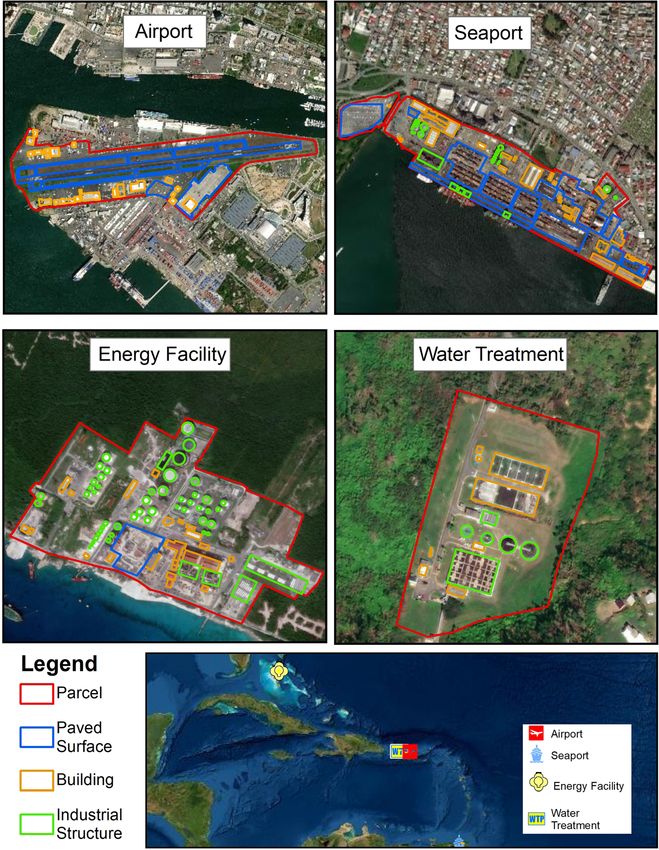
Becker et al. Journal of Infrastructure Preservation and Resilience     (2021) 2:13                                                        Page 9 of 16

 Fig. 3 Example mapped critical infrastructure facilities and key features. a Fernando Luis Ribas Dominicci Airport, Puerto Rico; b Port of Spain,
 Trinidad and Tobago; c Bahama Light and Power Clifton Pier, The Bahamas; d Planta De Tratamiento De Aguas Negras, Puerto Rico

for pilots. Rising air temperatures and decreasing air dens-                     Among the critical infrastructure facility types we digi-
ity over the coming century will impact airplane takeoff,                     tized, airports by far had the largest footprint in the
resulting in the need for longer runways. Increasing heat                     Caribbean in coastal regions. Depending on the size of
can buckle pavement, reduce payload limits, and lead to                       the airport and the requirements of the planes landing
other health and safety risks. Sea level rise and storm surge                 there, runways alone can require a large amount land.
further threaten airstrips that often extend directly over                    For example, the United States Department of Transpor-
the sea on filled land [65]. We identified 71 airports in the                 tation recommends a runways length of 9000 ft for a
Caribbean that meet the criteria of coastal critical infra-                   Boeing 737 [66]. Larger airports may have more than
structure, covering 10,588 ha of land (Table 4). At each air-                 one runway, in addition to taxiways, aprons, and land
port, we mapped paved surfaces including runways,                             area dedicated to terminal buildings and parking areas
aprons, taxiways, and parking areas, as well as building, in-                 for travelers. Given current climate conditions and the
cluding terminal buildings, hangars, and control towers.                      associated need for longer runways, our inventory could
An example of a mapped airport is included in Fig. 3a.                        be a useful tool to aid planners in designing and
Becker et al. Journal of Infrastructure Preservation and Resilience       (2021) 2:13                                                 Page 10 of 16

Table 3 Number of coastal critical infrastructure facilities and total land footprint in the Caribbean
Infrastructure Type                                # of            # of             Total footprint (ha.)                 # of features mapped
                                                   Facilities      Facilities
                                                                                    Parcels          Paved Surfaces       Buildings        Tanks
                                                   Identified      within 1
                                                                   km of
                                                                   Coast
Airports                                           147             71               10,589           1876                 671              N/A
Seaports                                           210             170              3704             792                  1494             735
Energy Facilities                                  136             98               4619             90.5                 1718             2280
Water & Wastewater Treatment Facilities            73              47               206              0.3                  174              81
Total                                              566             386              19,118           2759.52              4057             3096

Table 4 Airports results summary
Total footprint (ha.)                                                                   # of features mapped
Parcel                Runways               Aprons                Taxiway               Buildings              Terminal Buildings          Hangars
10,588.5              924                   493                   411                   539                    36                          87

Table 5 Seaports results summary
Seaport Type            # of              Total footprint (ha.)                                                          # of features mapped
                        facilities
                                          Parcel          Apron          Container Yard             Laydown Area         Buildings         Tanks
General Cargo           101               1668.9          39.6           151.4                      85.1                 886               322
Container Port          25                1154.1          27.8           353.7                      60.5                 407               100
Oil Terminal            19                826.8           0.65           –                          5.5                  115               313
Cruise Port             25                54.5            3.4            –                          2.2                  86                –
Total                   170               3704.3          71.5           505.1                      153.1                1494              735
Becker et al. Journal of Infrastructure Preservation and Resilience (2021) 2:13 Page 11 of 16
adapting airports in the coastal regions, where undevel- that can be distributed between islands and the global
oped land area is already scarce, and will become in- economy.
creasingly scarce with a changing climate. In total, we located and mapped 98 energy facilities
throughout the Caribbean region, including: fossil fuel
power plants, nuclear power plants, oil refineries,
Seaports
solar farms, and wind farms (Table 6). We mapped
Seaports serve as the economic lifeblood of island na-
the facility land area, buildings, structures dedicated
tions, many of which are served by only one seaport
to generating power, and tank farms used to store
which imports all materials and supplies that would be
fuel. An example of a mapped energy facility is in-
too expensive to transport via air. Island economies de-
cluded in Fig. 3c. In total, energy facilities covered
pend on cruise ports for tourism, container ports for im-
4619 ha of the coastal land in the Caribbean region.
ports/exports and transshipment, and bulk ports for the
Not surprisingly, as the size of the country and its
import/export of raw materials. Additionally, energy
population increased, so did the number of facilities
ports import valuable petroleum products needed for
and land area dedicated to generation of power and
road and air transport, as well as general power for the
the storage of fuels such as oil, petroleum, or natural
electric grid that powers other critical infrastructure fa-
gas. Of the 98 facilities mapped, only 8 used a renew-
cilities including desalination plants, water treatment
able fuel source such as solar or wind, with the rest
plants, and telecommunication systems. Across the 28
relying on fossil fuel as a primary fuel source to pro-
island nations in this study, we identified 170 individual
duce power. The reliance on fossil fuel power plants
seaports, which includes: container ports, cruise ports,
as a primary fuel source may be indictive of a level
oil terminals, and general cargo ports (Table 5). We
of reliability and consistent power supply associated
mapped the full outline of the parcel, the individual
with these fuels sources, in addition to supplying
buildings, key paved surfaces, and tank used to store pet-
large quantities of power with a relatively small foot-
roleum or other liquid products. An example of a
print on islands with limited land area to produce
mapped seaport is include in Fig. 3b. Results show that
enough power to supply a growing population and
3704 ha of Caribbean land was devoted to seaport
economy.
infrastructure.
Water & Wastewater Treatment Facilities
Energy facilities Society depends on safe, clean, treated water to prevent
Energy facilities play an important role in supplying disease and maintain health. Properly treated wastewater
power to the industries that drive economic growth and protects the environment and similarly prevents disease
development, in addition to powering homes and busi- in humans. Many water and wastewater treatment facil-
ness. With increased urban development in coastal re- ities are located in the coastal zone, as they either rely
gions, the placement of energy facilities is critical for on seawater as a source (e.g., for a desalination plant) or
supplying power to a growing population. In addition, a destination for treated water [15]. Though such facil-
energy facilities need access to a water source for cool- ities are not limited to coastal locations, such locations
ing, with sea water being a common source utilized due are often more cost effective, as the low elevation re-
to its high availability. For Island nations, reliance on re- duces the need for expensive pumping systems. In this
liable energy infrastructure that supplies consistent study, we identified 47 water treatment, wastewater
power is a vital function for maintaining health and well- treatment, and desalination facilities, encompassing 206
being among the residents of island nations, as well as ha of coastal land (Table 7). The limited number of
ensuring these countries can produce goods and services water and wastewater treatment facilities inventoried
Table 6 Energy facilities results summary
Energy Facility Types # of Total footprint (ha.) # of features mapped
facilities
Parcel Paved Surfaces Buildings Power Structures Tanks
Fossil Fuel Power Plant 66 1308.1 44.0 876 116 594
Nuclear Power Plant 1 15.0 1.1 15 7 38
Oil Refinery 23 3155.4 45.4 824 62 1658
Solar Farm 4 103.6 – 3 – –
Wind Farm 4 36.9 – – – –
Total 98 4619 90.5 1718 185 2280Becker et al. Journal of Infrastructure Preservation and Resilience (2021) 2:13 Page 12 of 16
Table 7 Water and wastewater treatment facilities results summary
Water Treatment Facility # of Total footprint (ha.) # of features mapped
Types facilities
Parcel Paved Surfaces Buildings Clarifiers Tanks
Water Treatment Plant 16 55.2 – 69 21 30
Wastewater Treatment Plant 27 119.5 0.32 77 64 29
Desalination Plant 4 31.4 – 24 – 22
Total 47 206.1 0.32 170 85 81
may be a result of the lack of a regional database and the sample polygon features for each mapper with
the challenges of locating these facilities. However, the those in the researcher dataset. We then divided the
Caribbean region does suffer for a lack of adequate re- area that intersected by the total area (i.e., intersect-
sources to treat water, with only 17% of the homes in ing + non-intersecting) of the joined polygons. In
the region directly connected to a form of water treat- comparison of the polygon overlap for parcels, we
ment (Fluence News [67]). found that an average of 83.6% of the polygon area
from the volunteer mapper derived dataset over-
Validation exercise/accuracy assessment lapped with our polygon parcels (Table 8). After the
One of the potential applications for this approach is exercise, we survey the mappers to identify the com-
tracking land use over time. For example, researchers ponents that the participants struggled the most with
could conduct an inventory every five years in order when completing the exercise. The most common
to monitor how infrastructure land use is growing or challenges of the exercise identified from the feed-
shrinking for a particular region. To this end, the ap- back was determining the boundary that surrounded
proach must be replicable such that different individ- a facility, particularly for facilities that were in
ual mappers would make the similar choices with densely developed areas. Three of the facilities that
respect to boundaries and classifying assets. To assess were mapped were problematic for participants, with
the accuracy and replicability of the methodology, we variability in the percentage overlap among mappers
hosted a validation exercise to compare results ob- (Fig. 4). In comparison to OSM, we found an average
tained by independent mappers for a subset of facil- of 82.8% overlap of polygon area between our dataset
ities within our database. We recruited 11 volunteer and the facilities mapped in OSM. Analysis shows
mappers with basic GIS skills. Using a random name that the variation may be indicative of the geographic
generator, two facilities for each facility type (eight fa- location of the facility, such as facilities in highly de-
cilities in total) were selected for testing. Facilities veloped regions or areas with lower resolution im-
represented areas from a variety of built-environment agery available, as well as the experience level
densities and had varying resolution satellite imagery. mappers have with GIS and the efficacy of the meth-
Prior to digitizing the facilities, mappers reviewed our odology we have developed. Overall, the results of
SOP and partook in a two-hour training exercise. this exercise suggest that our approach and SOP pro-
Once they reviewed the materials, each mapper was vide enough instruction such that different mappers
assigned four facilities and tasked with determining could obtain similar results, though additional train-
and digitizing the parcel boundary, buildings, and ing would be helpful to boost replicability. This
other features for each facility. We then compared validation exercise lends confidence to the replicabil-
the percent overlap between polygon boundaries to ity of this method for conducting such geospatial
determine the effectiveness of our methodology in analysis.
guiding mappers to create a dataset that matched the
one created by our research team. In addition, we
made comparisons to data derived from OpenStreet- Table 8 Results of the validation exercise and comparison with
Maps (OSM) for the same subset of facilities. How- Open Street Maps
ever, of the eight facilities selected for the validation % Polygon Overlap
exercise, only four were mapped in OSM for Dataset Mean Range SD
comparison.
Validation Exercise 83.6 45.4 14.1
To determine the percentage of parcel polygon (# of mappers = 11, # of facilities = 8)
overlap between our dataset and the participants OSM (# of facilities = 4) 82.8 38.1 18.1
dataset, we applied the Union tool in ArcMap to joinBecker et al. Journal of Infrastructure Preservation and Resilience (2021) 2:13 Page 13 of 16 Fig 4 Validation exercise comparison of polygon overlap among eight mappers for each facility type Discussion and implications While the Caribbean was used as a case study for this The primary purpose of this manuscript was to develop pilot, there are many other regions throughout the world a standardized, replicable approach to mapping critical with finite land area and infrastructure located in low- coastal infrastructure using the most-up-to date satellite lying coastal areas. Many will likely experience similar imagery. The resulting data can be used for a variety of climate related challenges. For example, island nations applications. For example, by running a regional sea located in the South Pacific are particularly susceptible level analysis, researchers can quantify the amount of to climate related hazards. A recent study on the expos- critical infrastructure at risk from inundation or storm ure of infrastructure to climate risks in the South Pacific surge on a more granular level than by simply using estimate that 57% of the infrastructure is located with point datasets. It could also be used for analysis of other 500 m of the coastline [12]. While this study was one of regional trends, such as tracking coastal land utilization the first to develop a comprehensive assessment of the over time, regional economic studies, or planning. The infrastructure assets vulnerable to climate risk, a point approach developed here provides empirical data that database was used to identify infrastructure, thus limit- has a higher level of precision than estimates based on ing the ability to determine the assets at greatest risk. more generic land use. For example, Dronkers et al. [68] The methodology we outline in this paper provides an developed an approach to estimate land use for ports opportunity to develop more detailed geodatabases that based on cargo throughput. This approach was subse- could be used for a comprehensive analysis of the assets quently improved by Hansen and Nicholls [69] for a and infrastructure at greatest risk in regions like the study that projected 2050 port land use demands based South Pacific. While other mapping techniques are avail- on a variety of economic and climate scenarios. The data able, the SOP standardizes the process of creating spatial resulting from the approach described in this study data for critical infrastructure features in a way that is could allow for validation, as well as for including a cost effective, fast, and useful for projects relying on par- wider variety of coastal infrastructure. Additionally, this ticipatory mapping to generate spatial data. The SOP data could be used to identify facilities and infrastructure can also be used as a complimentary guide pre-existing storing hazardous materials, such as oil refineries and mapping techniques as well as for the creation of geo- power stations, that could potentially release pollutants spatial data using OSM or other open source mapping into the surrounding ecosystem similar to what occurred applications. Additionally, the SOP can be utilized to in Galveston Bay during Hurricane Harvey [2]. allow for revisions as satellite imagery is updated.
Becker et al. Journal of Infrastructure Preservation and Resilience   (2021) 2:13                                                         Page 14 of 16

  Next steps for this work include an expansion of the                    available satellite imagery provided by ESRI. While the
approach to include other types of coastal land use (e.g.,                cost associated with accessing publicly available data was
marinas and emergency facilities), expanding the SOP to                   negligible, a reliance on this imagery presents several
include standardized approaches for mapping other crit-                   limitations as compared to formal imagery sources. For
ical infrastructure features, such as roads, bridges, and                 one thing, cloud cover sometimes presented challenges
railways within close proximity to coastal infrastructure                 in identifying infrastructure. In addition, the date of the
facilities, as well as conducting the study in other regions              imagery may vary with scale, meaning that as a mapper
around the world (e.g., the South Pacific). In addition,                  zooms in on a piece of infrastructure the image date at a
the data could be used to conduct a regional analysis of                  higher resolution could be several years earlier or later
Caribbean coastal infrastructure at risk from storm                       than that of the image at a smaller scale.
surge, similar to methods described in a pilot study we
conducted for the U.S. Virgin Islands [70].                               Conclusion
                                                                          This paper describes a cost effective, precise and stan-
Limitation of this approach                                               dardized approach to inventory critical infrastructure on
There are a few challenges and limitations to this ap-                    a regional scale. Using a heads-up digitizing approach,
proach that warrant discussion. This section describes                    the methods outlined in this paper can be used to create
some of the larger issues.                                                a high-resolution dataset for the land and key features
                                                                          dedicated to critical infrastructure. The dearth of such
Identifying facilities                                                    datasets has been identified as a barrier to conducting
This manuscript relies on existing point datasets and                     research to understand a variety of issues, especially in
Google searches to identify where facilities are located                  developing nations such as many of the islands in the
along the coast. It then develops those point datasets                    Caribbean. Along with high-resolution bathymetry and
into polygon datasets to allow for a more nuanced un-                     elevation data, land use data such as developed in this
derstanding of land use. For ports and airports, we were                  manuscript is the third major category of data necessary
able to find comprehensive datasets. However, for water                   to assess storm surge and sea level rise impacts to the
treatment and energy facilities, we relied more on Goo-                   coast at the local and regional scale. Using the 28 islands
gle searches to identify where on each island these facil-                in the Caribbean region to pilot the approach, we identi-
ities could be found. As such, it is possible that some                   fied 386 critical coastal infrastructure facilities, with over
facilities were missed. In next steps, we plan to expand                  19,000 ha of coastal land dedicated to critical infrastruc-
our approach to include other types of uses, such as ma-                  ture. This data can be available to other researchers who
rinas, hospitals, emergency facilities, and bridges. Some                 wish to conduct regional-scale work on climate vulner-
of these, such as marinas, have likely been assembled                     ability or other applications. Such geospatial datasets are
into databases that can be used to identify locations.                    necessary for a variety of analyses, including risk assess-
Others, however, will rely on a more hands-on approach                    ment and tracking land use change over time for a re-
through Google or other search engines.                                   gion. While other approaches to inventorying rely on
                                                                          complex or automated remote sensing or techniques to
Determining parcel boundaries                                             estimate land use, this approach utilizes satellite imagery
“Parcel” generally describes the boundaries of a piece of                 and a “standard operating procedure” that guides indi-
land held by a particular owner. Delineating such owner-                  vidual mappers through the process, ensuring replicabil-
ship boundaries through an inspection of satellite im-                    ity and confidence. The approach will be expanded and
agery would be an impossible task. For this project, we                   the SOP further developed to include other regions, such
consider the parcel to be the land area devoted to a par-                 as the South Pacific, and additional types of
ticular infrastructure use. In some cases, identifying this               infrastructure.
boundary was relatively straightforward, such as for a
river or a road. However, in other cases, the mapper
                                                                          Supplementary Information
needed to use their best judgement to determine where                     The online version contains supplementary material available at https://doi.
a parcel boundary should be drawn. Though we included                     org/10.1186/s43065-021-00019-0.
several “what if” instructions in the SOP, this type of de-
cision making could lead to errors in the dataset.                          Additional file 1.

Limitations in publicly available imagery                                 Acknowledgements
Acquiring high resolution satellite imagery at the re-                    The authors of this paper wish to thank the numerous undergraduate and
                                                                          graduate students who contributed to this effort, including Ellis Kalaidjian,
gional scale from a private company could be costly,                      Ben Sweeney, Nelle D’Aversa, Alex Sousa, Luis Cruz, Ryan DiPanni, and the
thus for purposes of this study, we relied on publicly                    volunteer mappers who helped validate the approach.
Becker et al. Journal of Infrastructure Preservation and Resilience (2021) 2:13 Page 15 of 16
Authors’ contributions 11. IPCC (Intergovernmental Panel on Climate Change). (2012). Managing the
AB and NH contributed to all aspects of the project, including research risks of extreme events and disasters to advance climate change adaptation:
design, method development, data collection, analysis, and writing. GB special report of the intergovernmental panel on climate change (SREX)
contributed to research design and method development. The authors read (9781139177245). Retrieved from Cambridge: http://ebooks.cambridge.org/
and approved the final manuscript. ref/id/CBO9781139177245
12. Kumar L, Taylor S (2015) Exposure of coastal built assets in the South Pacific
Funding to climate risks. Nat Clim Chang 5(11):992–996. https://doi.org/10.1038/
This work was supported by the USDA National Institute of Food and nclimate2702
Agriculture, Hatch Regional project 1014166, the Cruise Industry Charitable 13. Vousdoukas MI, Mentaschi L, Voukouvalas E, Verlaan M, Feyen L (2017)
Foundation, and the University of Rhode Island Research Office. Extreme sea levels on the rise along Europe’s coasts. Earth’s Future 5(3):304–
323. https://doi.org/10.1002/2016EF000505
14. de Moel H, Jongman B, Kreibich H, Merz B, Penning-Rowsell E, Ward PJ
Availability of data and materials (2015) Flood risk assessments at different spatial scales. Mitig Adapt Strateg
The datasets used and/or analyzed during the current study are available Glob Chang 20(6):865–890. https://doi.org/10.1007/s11027-015-9654-z
from the corresponding author on reasonable request. The data has been 15. Hummel MA, Berry MS, Stacey MT (2018) Sea level rise impacts on
made available to view through the University of Rhode Island ArcGIS Online wastewater treatment systems along the U.S. coasts. Earth’s Future 6(4):622–
page at https://tinyurl.com/amd746ey. 633. https://doi.org/10.1002/2017ef000805
16. Pek, S., & Caldecott, B. (2020). Physical climate-related risks facing airports: an
Declarations assessment of the world’s largest 100 airports briefing paper September
2020. Retrieved from Oxford, UK: https://www.smithschool.ox.ac.uk/research/
Competing interests sustainable-finance/publications/Physical-climate-risks-facing-airports-
The authors declare that they have no competing interests. briefing-paper-September-2020.pdf
17. Mirza MMQ (2003) Climate change and extreme weather events: can
Author details developing countries adapt? Clim Pol 3(3):233–248. https://doi.org/10.3763/
1
Department of Marine Affairs, University of Rhode Island, 1 Greenhouse Rd., cpol.2003.0330
Kingston, Rhode Island 02881, USA. 2University of the Virgin Islands, 2 John 18. Tol RS (2018) The economic impacts of climate change. Rev Environ Econ
Brewers Bay, St Thomas, V. I. 00802-6004, USA. Policy 12(1):4–25. https://doi.org/10.1093/reep/rex027
19. Phiri D, Morgenroth J (2017) Developments in Landsat land cover
Received: 4 February 2021 Accepted: 9 March 2021 classification methods: a review. Remote Sens 9(9):967. https://doi.org/10.33
90/rs9090967
20. Viana CM, Girão I, Rocha J (2019) Long-term satellite image time-series
References for land use/land cover change detection using refined open source
1. Bernie, C., & Padgett, J. (2020). Probabilistic assessment of storage tanks data in a rural region. Remote Sens 11(9):1104. https://doi.org/10.3390/
subjected to waterborne debris impacts during storm events. doi:https:// rs11091104
doi.org/10.1061/(ASCE) 21. Meyer WB, Meyer WB, BL Turner I (1994) Changes in land use and land
2. Du J, Park K, Yu X, Zhang YJ, Ye F (2020) Massive pollutants released to cover: a global perspective, vol 4. Cambridge University Press, Cambridge
Galveston Bay during hurricane Harvey: understanding their retention and 22. Abd El-Kawy O, Rød J, Ismail H, Suliman A (2011) Land use and land cover
pathway using Lagrangian numerical simulations. Sci Total Environ 704: change detection in the western Nile delta of Egypt using remote sensing
135364. https://doi.org/10.1016/j.scitotenv.2019.135364 data. Appl Geogr 31(2):483–494. https://doi.org/10.1016/j.apgeog.2010.10.012
3. Fisher IJ, Phillips PJ, Colella KM, Fisher SC, Tagliaferri T, Foreman WT, Furlong 23. Alphan H (2003) Land-use change and urbanization of Adana, Turkey. Land
ET (2016) The impact of onsite wastewater disposal systems on Degrad Dev 14(6):575–586. https://doi.org/10.1002/ldr.581
groundwater in areas inundated by Hurricane Sandy in New York and New 24. Spruce J, Bolten J, Mohammed IN, Srinivasan R, Lakshmi V (2020) Mapping
Jersey. Mar Pollut Bull 107(2):509–517. https://doi.org/10.1016/j.marpolbul.2 land use land cover change in the lower Mekong Basin from 1997 to 2010.
016.04.038 Front Environ Sci 8:21. https://doi.org/10.3389/fenvs.2020.00021
4. Fan H, Zipf A, Fu Q, Neis P (2014) Quality assessment for building footprints 25. Fu P, Weng Q (2016) A time series analysis of urbanization induced land use
data on OpenStreetMap. Int J Geogr Inf Sci 28(4):700–719. https://doi.org/1 and land cover change and its impact on land surface temperature with
0.1080/13658816.2013.867495 Landsat imagery. Remote Sens Environ 175:205–214. https://doi.org/10.101
5. Huth J, Kuenzer C, Wehrmann T, Gebhardt S, Tuan VQ, Dech S (2012) Land 6/j.rse.2015.12.040
cover and land use classification with TWOPAC: towards automated 26. Pauleit S, Ennos R, Golding Y (2005) Modeling the environmental impacts
processing for pixel- and object-based image classification. Remote Sens of urban land use and land cover change—a study in Merseyside, UK.
4(9):2530–2553. https://doi.org/10.3390/rs4092530 Landsc Urban Plan 71(2–4):295–310. https://doi.org/10.1016/S0169-2046(04
6. IPCC (Intergovernmental Panel on Climate Change) (2014) Change 2014: )00083-0
impacts, adaptation, and vulnerability. Part B: regional aspects. Contribution of 27. Seto KC, Güneralp B, Hutyra LR (2012) Global forecasts of urban expansion
Working Group II to the Fifth Assessment Report of the Intergovernmental to 2030 and direct impacts on biodiversity and carbon pools. Proc Natl
Panel on Climate Change. Cambridge University Press, Cambridge, p. 688 Acad Sci 109(40):16083–16088. https://doi.org/10.1073/pnas.1211658109
7. Cashman, A., & Nagdee, M. R. (2017). Impacts of climate change on 28. d’Amour CB, Reitsma F, Baiocchi G, Barthel S, Güneralp B, Erb K-H et al (2017)
settlements and infrastructure in the coastal and Marine environments of Future urban land expansion and implications for global croplands. Proc Natl
Caribbean Small Island developing states (SIDS). Caribbean marine climate Acad Sci 114(34):8939–8944. https://doi.org/10.1073/pnas.1606036114
change report card: science review, 157–173 29. Seto KC, Shepherd JM (2009) Global urban land-use trends and climate
8. Strobl E (2012) The economic growth impact of natural disasters in impacts. Curr Opin Environ Sustain 1(1):89–95. https://doi.org/10.1016/j.
developing countries: evidence from hurricane strikes in the central cosust.2009.07.012
American and Caribbean regions. J Dev Econ 97(1):130–141. https://doi. 30. Silva R, Martínez ML, Hesp PA, Catalan P, Osorio AF, Martell R, Fossati M,
org/10.1016/j.jdeveco.2010.12.002 Miot da Silva G, Mariño-Tapia I, Pereira P, Cienguegos R, Klein A, Govaere G
9. Biondi EL, Guannel G (2018) Practical tools for quantitative analysis of (2014) Present and future challenges of coastal Erosion in Latin America. J
coastal vulnerability and sea level rise impacts—application in a Caribbean Coast Res 71:1–16. https://doi.org/10.2112/si71-001.1
island and assessment of the 1.5 °C threshold. Reg Environ Change. https:// 31. Huq S, Kovats S, Reid H, Satterthwaite D (2007) Reducing risks to cities from
doi.org/10.1007/s10113-018-1397-4 disasters and climate change. SAGE Publications Sage UK, London
10. Giardino A, Nederhoff K, Vousdoukas M (2018) Coastal hazard risk 32. Benediktsson JA, Pesaresi M, Amason K (2003) Classification and feature
assessment for small islands: assessing the impact of climate change and extraction for remote sensing images from urban areas based on
disaster reduction measures on Ebeye (Marshall Islands). Reg Environ Chang morphological transformations. IEEE Trans Geosci Remote Sens 41(9):1940–
18(8):2237–2248. https://doi.org/10.1007/s10113-018-1353-3 1949. https://doi.org/10.1109/TGRS.2003.814625You can also read