THE ECONOMICS OF ECOSYSTEM SERVICES OF XIJIANG RIVER BASIN IN GUANGXI - BFN
←
→
Page content transcription
If your browser does not render page correctly, please read the page content below
The economics of ecosystem services
 of Xijiang River Basin in Guangxi
OUTLINES Backgrounds The status of Xijiang River Basin, Guangxi Methodology Results Discussions
Why biodiversity is important
20 Aichi Biodiversity Targets
Strategic goal A. Address the underlying causes of biodiversity          Strategic goal C: To improve the status of biodiversity by safeguarding
      loss                                                                     ecosystems, species and genetic diversity
Target 1: By 2020, People are aware of the values of biodiversity        Target 11: By 2020, at least 17 per cent of terrestrial and inland water, and 10 per
      and the steps they can take to conserve and use it                       cent of coastal and marine areas are conserved through systems of protected
      sustainably.                                                             areas…...
Target 2: By 2020, biodiversity values are integrated into               Target 12: By 2020 the extinction of known threatened species has been
      national and local development and poverty reduction                     prevented and their conservation status, particularly of those most in decline,
      strategies and planning processes and national accounts …                has been improved and sustained.
Target 3: By 2020, incentives, including subsidies, harmful to           Target 13: By 2020, the genetic diversity of cultivated plants and farmed and
      biodiversity are eliminated, phased out or reformed …….                  domesticated animals and of wild relatives is maintained,
Target 4: By 2020, Governments, business and stakeholders have           Strategic goal D: Enhance the benefits to all from biodiversity and ecosystem
      plans for sustainable production and consumption and keep the            services
      impacts resource use within safe ecological limits.                Target 14: By 2020, ecosystems that provide essential services, including
Strategic goal B. Reduce the direct pressures on biodiversity and              services are restored and safeguarded,
      promote sustainable use                                            Target 15: By 2020, ecosystem resilience and the contribution of biodiversity
Target 5: By 2020, the rate of loss of all natural habitats, including         to carbon stocks has been enhanced, through conservation and
      forests, is at least halved and where feasible brought close to          restoration, including restoration of at least 15 per cent of degraded
      zero, and degradation and fragmentation is significantly                 ecosystems,
      reduced.                                                           Target 16: By 2015, the Nagoya Protocol on Access and Benefits Sharing is in
Target 6: By 2020 all stocks managed and harvested sustainably, so             force and operational
      that overfishing is avoided …….                                    Strategic goal E. Enhance implementation through participatory planning,
Target 7: By 2020 areas under agriculture, aquaculture and                     knowledge management and capacity building
      forestry are managed sustainably, ensuring conservation of         Target 17: By 2015 each Party has developed, adopted as a policy instrument, and
      biodiversity.                                                            has commenced implementing an effective, participatory and updated
Target 8: By 2020, pollution, including from excess nutrients,                 NBSAP.
      has been brought to levels that are not detrimental to             Target 18: By 2020, the traditional knowledge, innovations and practices of
      ecosystem function and biodiversity.                                     indigenous and local communities and their customary use, are respected.
Target 9: By 2020, invasive alien species and pathways are identified    Target 19: By 2020, knowledge, the science base and technologies relating to
      and prioritized, priority species are controlled or eradicated,          biodiversity, its values, functioning, status and trends, and the
      and measures are in place to manage pathways to prevent their            consequences of its loss, are improved, widely shared and transferred,
      introduction and establishment.                                          and applied.
Target 10: By 2015, the multiple anthropogenic pressures on              Target 20: By 2020, the mobilization of financial resources for effectively
      coral reefs, and other vulnerable ecosystems impacted by                 implementing the Strategic Plan for Biodiversity 2011-2020 from all
      climate change or ocean acidification are minimized, so as               sources,, should increase substantially .
      to maintain their integrity and functioning.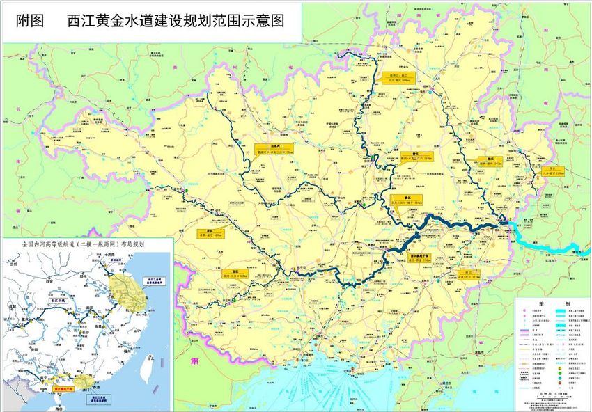
What is TEEB?
Initiated by
Objectives
• To highlight the growing cost of biodiversity
loss and ecosystem degradation
• To help decision-makers recognize,
demonstrate and capture the values of
ecosystems & biodiversity
• To raise the awareness to the value of nature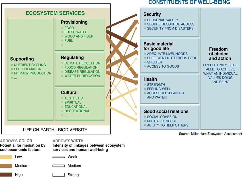
TEEB in the world
A case study at sub-national level:
   Xijiang River Basin, Guangxi
次国家级案例研究:广西西江流域
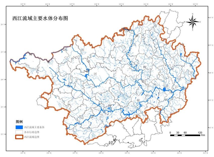
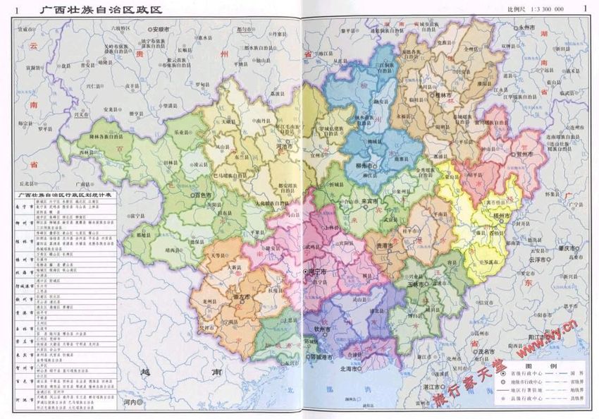
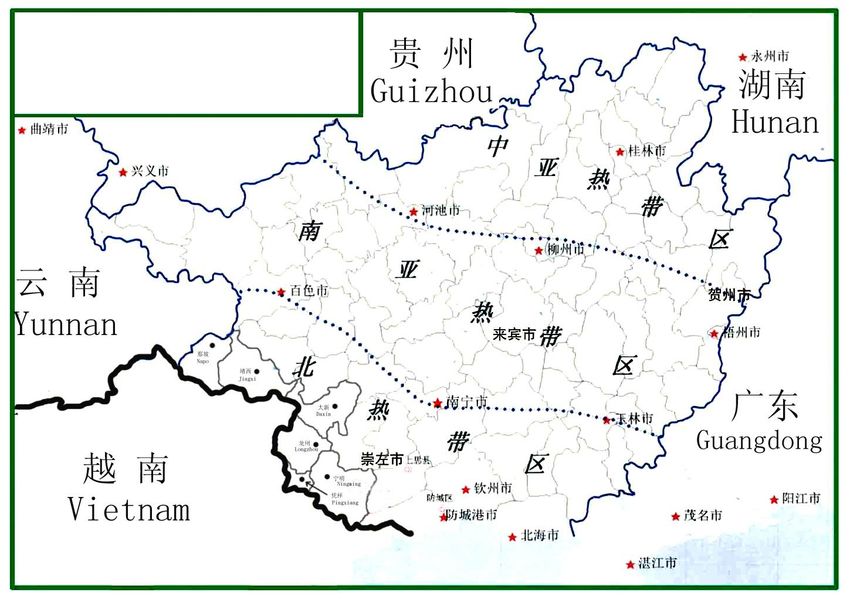
Xijiang River Basin in Guangxi Guangxi is one of five Autonomous regions in China Pearl River runs through Guangxi, the basin of 453,690 km2, Xijiang River Basin in Guangxi is a part of the Pearl River Basin Land coverage of Xijiang River Basin in Guangxi is 202,500 km2 Population in 2013:46.03 million GDP in 2013:17,880 million USD
Northern Guangxi

         丰富的生物多样性资源
Hotspots in Guangxi

                      Central Guangxi

 South-west Guangxi
Ecosystems services provided
Regulating services:
water purification: Water should achieve III
water quality standard before it goes to
Guangdong
Flood regulation
Conservation of water and soil
Provision services:
Fresh water: 70% of the fresh water (totally
20 billion tones) demanded by Pearl River
Delta Region is provided by Guangxi
High air quality
Timber
Supporting services
Primary productivity
Soil formation
China
Environmental
Bulletin, 2013
The water quality of the Pearl River, 2013 (MEP)Threats to ecosystem services Soil erosion:24,862 km2 , taking 12.27% of total land coverage, especially within the area of slope farmlands; Stony desertification: stony desertification land 23,790 km2 , potential desertification land18,670 km2 ,taking 20.96% of total land coverage; Water pollution: arable land 42,400 km2 , taking 21.47% of total land coverage, becoming an important non- point pollution source to water Landuse change: the expansion of built up areas, road networks, industrial lands, minings, etc.
Ambitious development plan
Xijiang Golden canal construction
plan(2010-2020)
By 2012, 70 million tons port handling
capacity is increased, total handling
capacity reach 100 million tons.
By 2020, a canal network with a length
of 1,480km, connecting the major cities
in the Basin is accomplished.The purpose of the study
In 2010, Environmental Protection Bureau of Guangxi Autonomous
Region invited CRAES to initiate a study in the Basin, with the aim of:
To elaborate the implementation plans for Ecology and Environment Protection in
Xijiang River Basin for the guidance of environmental practices in the
implementation of the Xijiang Gloden canal construction plan(2010-2020);
To provide an positive and supportive evidence to the government of Guangxi
Autonomous Region for supporting their consultation with Guangdong Province in
eco-compensation dialogue.The diverse of methodologies for evaluation
InVEST model(The Integrate Valuation of
Ecosystem Services and Tradeoffs Tool),
Developed jointly by Stanford University, WWF and TNC;
Comprised by:
Water model: including water production, water conservation, water
quality, flood reduction, soil conservation, sedimentation reduction,
irrigation, hydropower, etc., and;
Non-water model: biodiversity conservation, timber harvesting,
agriculture, pollination, carbon sink, non-timber production, etcInVest model
Three tier is given for each model: simple, moderate and
complex
Tier 1 Tier 2 Tier 3
Modeling reality
Simple Complex
Data reality
Less Data More Data Most DataTechnology roadmap
InVEST model introduction Field survey and data collection
Data demands study Data processing
Literature review GIS
InVEST model
Model adjustment and
Parameter calibration
Result verify
Application in study area
Non-point Carbon
Sediments Timber
pollution storage and
reduction oxygen provision
reduction
Value for ecosystem services
Ecological function zoning and planingInVest model-Data collection 以2008年为基准年的统计公报数据 相关科研成果 收集各类资料,共计100余件 各类规划报告 遥感、GIS信息源 野外调研校对数据
Karst landscape
          Field survey

                                                                 Natural resources

        Field survey focus on
                  Field survey
             The status and threats of important ecosystems
             Anthropogenic impacts such as deforestation, dam   Dam construction
             building, road construction, agriculture on

Stony desertification       deforestation             Mining      Road construction
Interviews
Interviews focused on:
Social-economics and livelihoods
Administration and management for
Interviews
environment and nature conservationThe aspects of modeling Non-point source phosphorus loads filtering sedimentation reducing carbon storage and oxygen releasing Timber provision
Results
研究结果
Ecosystem service value for phosphorus loads filtering
Hydrology Tools based on ArcGIS9.2
Water, pollutant solutes and sediments conjugate transport
theory
The identification of Critical Source Areas(CSA) by using
Hydrological Sensitive Coefficient(HSC)
Modeling the filter of phosphorus by vegetation, taking into
account the landuse
The standard for drainage fees collection and its calculation,
14¥·kg-1 for phosphorusEcosystem service value for sedimentation reducing
The establishment of the model for sedimentation reduction
based on Universal soil and water loss equation(USLE) and
sediment delivery ratio (SDR) and relevant hydrological theories
Simulating potential and actual soil erosion and soil retention by
using USLE
Identification SDR by considering of the source of sediments,
landuse, slope, gully density, catchment area, etcEcosystem service value for carbon storage and
oxygen releasing
Solar energy can be transformed into plant organic carbon content though
Photosynthesis, 1.62gCO2 /1g plant dry matter
Modelling Net Primary Productivity (NPP) by using light use efficiency
model for identification of plant dry matter
Other indicators, such as vegetation type, climate data and ecological
parameters gathered in the field are taking into account
In China, the average cost of forestation is about Y260.9/t carbon, the value
of O2 releasing is also modeled by the cost of industrial oxygen
methodology(Y0.4/t).Ecosystem service value for Timber provision
Timber provision were modeled by 5 indicators: annual product stocks,
habitat quality adjustment coefficient, harvesting pressure coefficient, and
management coefficient and availability in neighborhood.
annual product stocks : Statics data and the main forest types in the 1266
sample plots data;
Habitat quality adjustment coefficient: NPP and vegetation coverage;
harvesting pressure coefficient: The distance between residential area and
road networks;
Legal access coefficient: natural reserves networks
Availability in neighborhood: vegetation, residential and road, etc.Ecological regulating Goods and services Settlement security
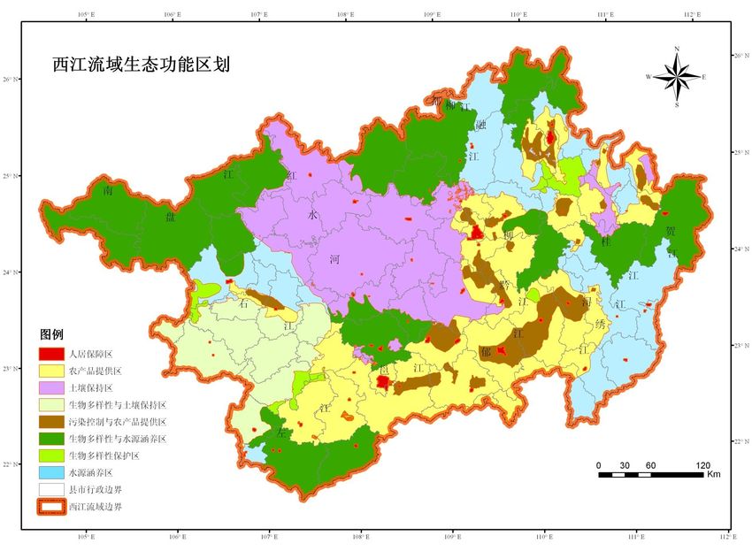
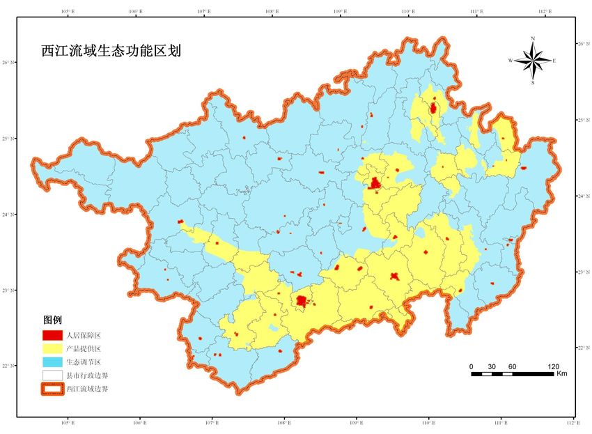
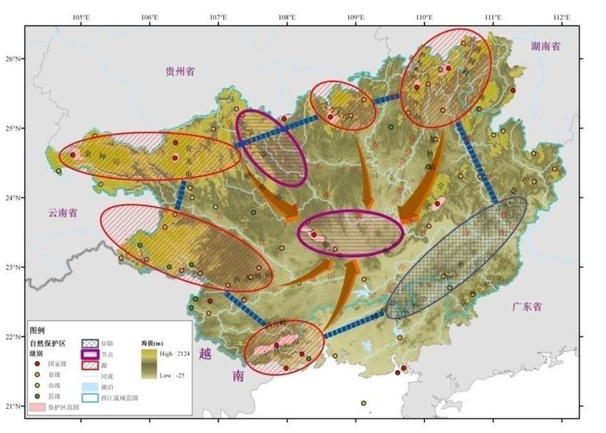
Designation of Ecological function zoning
9 secondary
zone and 71 third class zones were
provision zonealso identified based on the
zone
designation of primary zones. Major ecosystem problems and conservation
An ecological function zoning plan was initialized based on the analysis of space
measures were also pointed out respectively.
distribution of ecosystem services values, taking into account with social-economic and
other ecological factorsNon-point source emission
control
Non-point source emission control plans
Non-point source emission control
areas identification
National ecological towns
construction initiative, including:
establishing fenced area for
natural vegetation restoration;
soil testing and formulated
fertilization;
sewage treatment plants
construction;
Above-scaled livestock farming,
etc.Soil erosion and stony
desertification control plans
Identify the priority areas for ecosystem
restoration
Ecosystem restoration plans
Water and soil restoration in Slope
cultivated lands
Small watershed restoration
Stony desertification control, taking into
account project for poverty reductionMaintaining goods and
services
Natural reserve networks
Improving the spatial pattern of
natural reserve networks,
including: the establishment of
new natural reserves along
Fenghuang mountains, Duyang
mountains, Liuwandashan
mountains and Dagui mountains;
Establishing 8 biodiversity
corridors.Discussions 讨论
About the project
An practice for applying an scientific TEEB model into policy making
plans;
Enhancing the scientific base for policy making;
Improving the awareness to the importance of ecosystem services
among decision makers;
Difficulties in data collecting stages;
Gaps between the outputs of modeling and the realities of Basin;
Gaps between the outcomes and decision making.About the implementation
An study report and an implementation plan was adopted by an expert meeting submitted
to the Environmental Protection Bureau of Guangxi Autonomous Region in 2011. The EPB
of Guangxi is taking a lot of efforts to implement the implementation plans for Ecology and
Environment Protection in Xijiang River Basin. However, more efforts need to be done by
other relevant provincial authorities. More politician willingness is needed.
A new message for trans-provincial eco-compensation dialogue .In 2013, Mr. Hu Chunhua,
the Secretary of CPC Committee of Guangdong Province, has expressed his willingness to
initiate a pilot project in Hedi reservoir, a small basin at local level, for eco-compensation,
in collaborate with Guangxi AR.About InVEST model
It is useful for the rapid valuation of ecosystem services at
river basin level;
However, The lack of data at sub-national level is the major
obstacle for the application of InVest model in China;
it is not appropriate to apply the model for the case studies
in China without any modification and parameter correction.Look into the future
As Mr. Xi Jinping, the President of
China, has highlighted, “We want
both golden, silver hills and clean
water, green mountains. Let’s bear in
mind that clean water and green
mountains is also golden, silver hill.”
The concept of the TEEB and the
application of its relevant tools such
as InVest model are going to have a
very good prospects in National’s
ecological civilization strategy.Thank you!
Danke!
谢谢! Email: xujing263@163.com
XU JingYou can also read