The Federal Emergency Management Agency (FEMA) Map Modernization Program
←
→
Page content transcription
If your browser does not render page correctly, please read the page content below
Watershed Update                                                 Vol. 3, No. 3
May - June 2005

       The Federal Emergency Management Agency (FEMA)
                   Map Modernization Program

                                Compiled by:
                               Moris Cabezas
                                   PBS&J
                               Tampa, Florida
                      Email:

                           (Source - http://www.fema.gov/)

                                1
________________________________________________________________
AWRA Hydrology & Watershed Management Technical Committee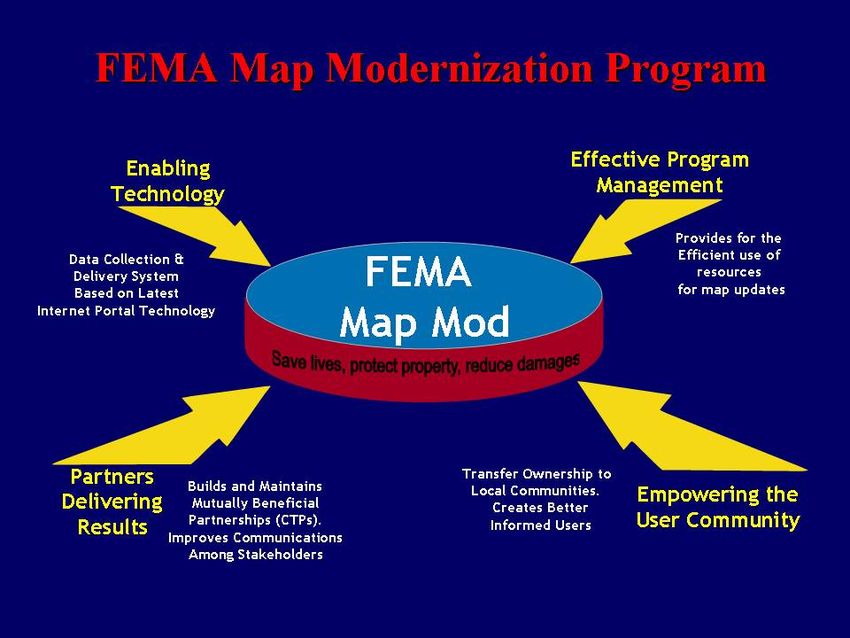
Watershed Update                                                          Vol. 3, No. 3
May - June 2005

            The Federal Emergency Management Agency (FEMA)
                        Map Modernization Program

        FEMA has embarked in the Flood Insurance Rate Maps (FIRMs) Map
Modernization. The objective is to make the flood maps more reliable, easier to use and
update, and readily available to the communities. In this manner, flood maps become
better tools to prevent and reduce flood losses. FEMA envisioned the Map Modernization
program to be a process that is developed through strong partnerships with State,
regional, and local agencies that would contribute resources, expertise, and most
importantly, local knowledge.

       The Map Modernization Program has now been underway for more than five
years. As a follow-up of previous issue in 2004 (“Latest on Flood Insurance Program
and Digital Mapping Tools”, Volume 2, No. 5), we thought it would be important to
share with the readers the impressions and experiences of various participants regarding
program implementation. Following are papers that address perspectives from FEMA
Region IV, the State of Georgia Department of Natural Resources, and the Florida Water
Management Districts.

     #1: FEMA’s Multi-Hazard Flood Map Modernization Program
            (Map Modernization) – FEMA’s Perspective
       FEMA's overall vision is to create “A Nation Prepared.” To support this vision,
FEMA has embarked on an aggressive 5-year initiative to update the Nation's flood
hazard maps. This initiative has been funded by the President and Congress. Map
Modernization will transform the Flood Insurance Rate Maps (FIRMs) into a more
accurate, easier-to-use, and readily available product. Updated, digital FIRMs will
become the platform for identifying multiple hazards—not just floods. Specifically, Map
Modernization will achieve the following goals:
       • Create a premier hazard map collection and technically advanced delivery
         system to support risk management.
       • Achieve effective program management by sharing responsibilities and aligning
         partner missions.
       • Build and maintain mutually beneficial partnerships by communicating hazard
         risk information.
       • Establish better understanding of where to obtain flood hazard data and how to
         use the information for sound mitigation decisions.

                                2
________________________________________________________________
AWRA Hydrology & Watershed Management Technical Committee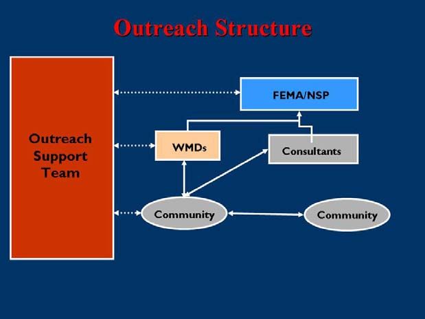
Watershed Update Vol. 3, No. 3
May - June 2005
Accurate information about risks is the first step in preventing and reducing
losses. In emergency management, risk information is the key to mitigation. Flood maps
are a powerful tool for mitigation and are referenced an estimated 20 million times
annually. Today, many of the Nation’s flood maps are outdated, severely limiting their
usefulness. An estimated 30 million Americans are at high risk from flooding, and almost
every American is at some degree of flood risk. Communities, Developers, Insurance
agents, Lenders, Home owners and Business owners all use the FIRMs to determine their
flood risks and make better informed development decisions. It is imperative to make
sure that accurate, up to date information is available for all these users of the Flood
Insurance Rate Maps.
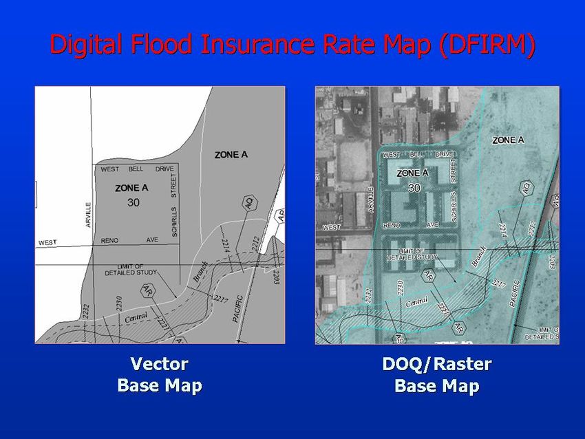
With rapidly changing technology, an important deliverable of the Map
Modernization program is the development of a digital Flood Insurance Rate Map
(DFIRM).
Having the
FIRMs in a
digital format
will allow for
the immediate
access to local
officials,
developers
and the
general public.
It will also
create a
simplified
utilization of
these Maps for
all users by
allowing them
to overlay
their flood
hazard with
localized information and other hazard information.
Map Modernization is a collaborative process and a new way of doing business
for FEMA, cutting across all layers of government. Officials and other stakeholders will
be active in the mapping process (e.g., collecting, updating, and adopting data). Local
engineering companies are contracted to do the mapping and determine where the high,
medium, and low flood risk zones are located. The maps are reviewed and adopted by the
local government and FEMA. Leveraging partnerships will allow States and communities
to choose their level of involvement. These Partnerships will be maintained through the
Cooperating Technical Partners (CTP) Program to manage the flood hazard data
3
________________________________________________________________
AWRA Hydrology & Watershed Management Technical CommitteeWatershed Update Vol. 3, No. 3
May - June 2005
development, in coordination with FEMA, which will update the Digital Flood Insurance
Rate Maps.
FEMA has set targets or Key Performance Indicators (KPI) through FY09. These
are designed to measure population for whom maps are available online and population
for communities whom have adopted effective maps. FEMA also uses other KPIs related
to leveraging partnerships and creating partnerships as well. There are many challenges
to the success of Map Modernization. Some of these include: managing the magnitude of
work that will be completed, working with and maintaining partnerships with CTPs, and
meeting the KPIs overall with resources available. FEMA has already begun to work on
these challenges to ensure success. To create better ways to manage and oversee
projects, FEMA is creating the Mapping Information Platform (MIP) which you can view
at www.hazards.fema.gov. We are also working very closely throughout the Nation to
assist and support our Partners in the CTP program in order to ensure KPIs are met and
Map Modernization is successful.
Please feel free to go to FEMA’s new website, the MIP, for up to date Map
Modernization Information at www.hazards.fema.gov.
Article contributed by: Laura Algeo, P.E.
FEMA Region IV
Atlanta, GA
#2: Georgia Takes FEMA Flood Mapping Project by Storm
When FEMA envisioned the Map Modernization Program, they knew it would
require strong support from the state and local agencies to effectively upgrade the entire
100,000-plus flood panel map inventory. Because of the critical significance of these
maps, FEMA hoped states would contribute resources and expertise to aid in this process.
The State of Georgia took on an ambitious role to do just that. As a Cooperating
Technical Partner with FEMA, Georgia, through the Georgia Department of Natural
Resources (DNR), is managing a six-year, $18.2 million Flood Map Modernization
Program designed to create and update flood insurance rate maps (FIRMs) for all 159
counties and 531 communities in Georgia by 2009. Nearly 7,000 DFIRM maps are
expected to result from this process.
According to Nolton Johnson, P.E., Chief of Georgia’s Water Resources Branch
of the Environmental Protection Division, “We see this as a tremendous opportunity for
4
________________________________________________________________
AWRA Hydrology & Watershed Management Technical CommitteeWatershed Update Vol. 3, No. 3
May - June 2005
Georgia to create a climate of understanding and ownership for the mapping process.
Georgia's map modernization program is unique in that it provides in-kind personnel
services that fill voids in federal funding for mapping needs and in the large number of
local governments involved". In fact, Georgia’s maps utilize a wealth of local data to
create significantly improved flood zone delineations. Despite very tight budgets,
Georgia has been able to incorporate some new flood studies in almost every county.
Now well into the third year of production, this unique project is a magnet for
unprecedented collaborative data gathering between state, regional, and community
groups.
Testing the Waters
The Flood Map Project began in 2003 when the Georgia DNR map modernization
team began the project with the conversion of about 200 FIRMs along with the related
data updates to digital format for three counties: Henry, Gwinnett and Union. While
selected at random, these counties are representative of Georgia in terms of population
growth, flooding issues and other related planning scenarios.
At the beginning of the map modernization effort, the map modernization project
team established a scoping process with the local county officials to refine planning level
cost estimates based on detailed assessment of flood map update needs. These meetings
have included floodplain administrators, public works directors, zoning and planning
staff, and building permit staff from the community. Other state agencies, such as the
Georgia Department of Transportation, are also often represented, as their interests and
projects often impact the floodplain. Also, federal agencies with flood control or flood
modeling roles such as the United States Geological Survey (USGS), U.S. Army Corps of
Engineers (USACE), Natural Resources Conservation Service (NRCS), and Tennessee
Valley Authority (TVA), provide representation as well. Any agency with a vested
interest in improving the quality of flood maps within a county is invited.
Collis O. Brown, CFM, NFIP Coordinator for the State of Georgia, explains,
“These communities are in the best position to supply this type of information primarily
because they are at the ‘ground level’ - they understand their flood control infrastructure
better than anyone else and can ‘ground truth’ what the DNR is putting together”.
Detailed Maps
The converted digital maps go well beyond the traditional paper maps that simply
depict the state’s floodplains. Built in a geographic information system (GIS) framework
per FEMA standards, Georgia’s digital FIRMs reflect a distinctly state and local
5
________________________________________________________________
AWRA Hydrology & Watershed Management Technical CommitteeWatershed Update Vol. 3, No. 3
May - June 2005
emphasis, drawing information from local detailed flood analysis models, topographic
maps, and aerial photography, as well as state information of the same types. The DNR
technology framework includes ArcGIS 9.0 mapping and spatial analysis software from
ESRI, customized Visual Basic (VB) programming, as well as a number of industry-
standard flood hazard data study tools, like HEC-RAS and HEC-HMS.
Data acquisition and hydrology and hydraulics (where applicable) are a part of the
process and encompass the acquisition or manipulation of data into a format useful for
the Flood Insurance Study. In addition, the project mapping specialists register the data to
the Georgia state plane coordinates, rectify aerial photos, and where possible, incorporate
hydrologic and hydraulic studies completed by others.
Georgia has recently pioneered two new technical standards for the map
modernization project: one for “Limited Detail” study and one for future conditions
mapping. “Limited Detail” study is a hybrid of traditional FEMA approximate study and
detailed study, and combines the usefulness of locally-available digital topography with
supplemental field measurement of hydraulic structures. Georgia has developed and
implemented a statewide standard for the creation of this data, and the display of the
information on the DFIRMs. Likewise, the State has developed a standard for the display
of future conditions floodplains on the DFIRMs. Within the Atlanta Regional
Commission planning area, computation of future conditions floodplains is mandated by
local ordinance, and this data can be displayed on DFIRMs by FEMA specifications.
Georgia developed and coordinated a simple method to display this data, resulting in a
low-cost, but highly-useful addition to the DFIRM.
Following this, the State produces the actual GIS DFIRMs using the data gathered
or transferred from effective maps. This is a detail-oriented process that involves
matching the floodplains to available orthophotography and base mapping and also
prepares the cartographic labeling and layouts for the final maps.
Community Review
Once the preliminary map is complete, it is issued to the community for review
and formal comment. A meeting is held with the community approximately 30 days after
map issuance to discuss the new product. A 90-day appeals period is held if new flood
elevations have been posted on the map, and then a 6-month compliance period begins
where the community must adopt new floodplain ordinances to match the revised map.
Once the community has adopted the new ordinances, the new map becomes effective
and is ready for insurance and floodplain management purposes.
6
________________________________________________________________
AWRA Hydrology & Watershed Management Technical CommitteeWatershed Update Vol. 3, No. 3
May - June 2005
Brown adds, “This is such a shift in traditional mapping roles. We’re working
side-by-side with the local community. We host public meetings and even conferences
that cover everything from the details necessary to customize a map for that particular
area to the demonstration of future conditions floodplains which lines with regulatory
requirements”.
From a Trickle to a Flood
Full-scale
DFIRM production is
currently underway
for Cherokee, Cobb,
Coweta, Floyd,
Gwinnett, Hall,
Henry, Paulding, and
Union counties in
Georgia. The DNR
team has already
issued preliminary
maps in Henry and
Coweta Counties for
review. In Union
County, preliminary
maps have been
issued, and the team is incorporating additional technical data into a revised version of
those maps. All six remaining counties will have preliminary DFIRMs issued to the
communities by September 2005.
The Georgia DNR Map Modernization team maintains a publicly-available
website (www.georgiadfirm.com) that tracks map modernization progress by county,
provides a wealth of downloadable documents, program contact information and
additional links, and allows the electronic submittal of mapping data quickly and easily.
The State is utilizing the web site to distribute PDF versions of preliminary maps for
public review and comment. Additionally, the site contains groundbreaking outreach
material designed for a range of audiences. Finally, the State is utilizing a team
collaboration site to facilitate communication among the State, its contractor, and FEMA.
As part of the FY2005 effort, the Georgia DNR is managing map updates for
nineteen more counties, including Bartow, Bibb, Carroll, Chatham, Clarke, Clayton,
Columbia, Dekalb, Douglas, Fayette, Forsyth, Glynn, Houston, Lowndes, Muscogee,
Newton, Richmond, Walker, and Whitfield Counties.
7
________________________________________________________________
AWRA Hydrology & Watershed Management Technical CommitteeWatershed Update Vol. 3, No. 3
May - June 2005
Award-winning Collaboration
Georgia recently won a special “Best Practices” grant from FEMA to implement a
regionally-based flood map scoping system based on the boundaries of the Regional
Development Centers (RDCs) within the State. FEMA clearly recognized the State’s
special success in the area of outreach, and, by providing this special grant, is nationally
spotlighting Georgia’s groundbreaking efforts, and the State’s unique position as the one
with the most counties in the United States. Georgia’s successful grant application
highlighted a plan to consolidate the scoping process at the regional level, reducing travel
costs and staff requirements, while at the same time drawing on the well-established
benefits of the RDCs for outreach, community coordination, and GIS support. Look for
several “lessons learned” publications as Georgia implements this one-of-a-kind process,
and pioneers the methodology for other states.
Georgia’s five-year Flood Map Modernization Program is expected to be
complete in FY 2009 depending on funding. Currently FEMA is providing the majority
of the funding with the State of Georgia and local counties providing substantial amounts
of in-kind services, primarily in the form of digital topographic data and community
flood studies. While budgets are extremely tight, the resulting maps issued to the public
continue to reflect the highest quality. Georgia is presently projecting a nearly one-to-one
in-kind services and data cost share match with FEMA funding over the life of the
program. Primarily, this is because of the availability of statewide orthophotography, and
a relatively high number of counties with recent topographic data.
Georgia’s program epitomizes collaboration and thrift, focusing on bringing
together a wide range of partners, communicating effectively among partners, and getting
useful data onto the DFIRMs cost-effectively. With a very limited budget, the state is
aggressively promoting the program and the collaborative efforts, while producing
quality GIS DFIRMs in some of the fastest growing counties in the United States.
Article contributed by: Michael DePue, P.E.,
PBS&J
Beltsville, MD
8
________________________________________________________________
AWRA Hydrology & Watershed Management Technical CommitteeWatershed Update Vol. 3, No. 3
May - June 2005
#3: Florida Water Management Districts Continue Collaboration
on FEMA Map Modernization Issues
At the April 2005 Federal Emergency Management Agency (FEMA) Region IV
Cooperating Technical Partners annual meeting held in Atlanta, a group of attendees
from Florida broke away from the general sessions to participate in a discussion on the
unique issues facing Florida in implementing the Map Modernization program. Present
at the meeting were representatives from each of the five water management districts
(WMDs), the Department of Community Affairs (DCA), FEMA Region IV, National
Service Provider (NSP), and interested consultants. A similar meeting between the
WMDs and DCA was held in March 2005 in Orlando, Florida.
The group was
initiated because as
Cooperating Technical
Partners (CTP), the
WMDs see the necessity
of a coordinated approach
to implementing Map
Modernization and the
advantages of dealing
with issues as a united
front. Also, discussions
provide opportunities to
learn from others on
program strategies and
experiences. The agenda
covered a variety of
items:
• Shared Counties-WMD boundaries are based on watersheds, but Map
Modernization projects are designated by county. Several counties in Florida are
under the jurisdiction of more than one WMD. Issues to address include:
1) How will FEMA funds be allocated?
2) How will workload be distributed?
3) How will outreach message be consistent?
4) How to handle critical data such as GIS from differing systems?
5) What will be the technical approach?
6) How to develop DFIRM mapping panels?
7) What is the best mechanism for formalizing each WMD's responsibilities
(e.g. via an inter-local agreement)?
9
________________________________________________________________
AWRA Hydrology & Watershed Management Technical CommitteeWatershed Update Vol. 3, No. 3
May - June 2005
• Statewide LiDAR- Accurate topographic information is critical for good flood
maps. FEMA is hesitant to fund this task. A statewide LiDAR contract would
yield other benefits outside flood protection with additional partners and funding
sources being pursued. State-wide LiDAR specifications are necessary to
develop useful data and maintain consistency across WMDs.
• Modeling Approaches/Constraints - Hydrology and hydraulics in Florida are
more complicated and detailed then most of the United States. In addition, the
data collected and information produced by the WMDs support more than just
insurance rate map production. Issues discussed were:
1) Standardize modeling approaches and database design standards;
2) Constraints, initial stages and boundary conditions;
3) Actual costs greater than FEMA's “blue book” amounts, need to track
expenditures to document;
4) Floodway issues;
5) WMDs' regulatory requirements and ERP thresholds;
6) Appropriate models specific to site conditions; and
7) Vertical datum conversion from the National Geodetic Vertical Datum
(NGVD) 1929 to North American Vertical Datum (NAVD) 1988.
• GIS/Database Specifications - Consistency between WMDs. Coordinate on
nomenclature, Arc Hydro, and guidelines for Map Modernization.
• Rainfall Distribution & Design Storms - Differences seen in ERP design
storm versus floodplain analysis requirements and design storm rainfall depths
developed by the WMDs. Explore opportunities for isopluvial curves for the
entire state.
• Coastal Flood Mapping - FEMA methodology changes include extending V
zones to toe of primary frontal dune and wave set-up. Changes amplify
outreach, agency coordination, and funding issues. Regional studies, one for
the Gulf coast and one for the Atlantic coast of Florida, proposed.
• State Coordination - Collaborative effort is required between WMDs, DCA
and FEMA Map Mod team. Communication and speaking with a unified
voice will benefit Florida in implementation of the Map Modernization
Program.
The group feels progress has been made already on many of these issues and
another meeting is scheduled for this summer.
Article contributed by: Lisann Morris, P.E. and Stephanie Dunham, P.E.
Southwest Florida Water Management District
Brooksville, FL
10
________________________________________________________________
AWRA Hydrology & Watershed Management Technical CommitteeYou can also read