The Future Challenge Assured Position, Navigation and Timing: Northrop Grumman ...
←
→
Page content transcription
If your browser does not render page correctly, please read the page content below

Assured Position, Navigation and Timing:

The Future Challenge

                                                                                                     Northrop Grumman has a long and
                                                                                                     distinguished history of supplying trusted
                                                                                                     navigation and positioning systems for a
                                                                                                     wide range of US ships and aircraft
                                                                                                     (US Navy/Lt j.g. James Griffin)

the use of global navigation Satellite            markets, utilities and transport all rely on its   has never been usable underwater or in
Systems (gnSS), largely through the uS            capabilities.                                      deep space.
global Positioning System (gPS), pervades
almost every area of modern life, and             However, there is now increasing concern           There is therefore a need for devices to
this is particularly true of the military.        about overreliance on GPS given the                replicate the integrity and reliability of GPS
there are few, if any, aspects of military        fragility of the signal. GPS is vulnerable to      to provide an alternative Assured PNT
operations that are not dependent on              jamming, interference and “spoofing” –             (APNT) capability which will provide positional
Pnt: Position (knowing where you are),            the attempted deception of the receiver            data with the same accuracy as GPS, and
navigation (how you are going to get to           by the broadcasting of incorrect signals.          timing with the equivalent traceability to that
where you want to be) and timing.                 During the Russian exercise “Zapad                 derived from the atomic clock. This must not
                                                  2017” GPS signals were reportedly lost by          only address the requirements of GPS users
It is unlikely that any modern military mission   commercial aircraft and other platforms            who are temporarily denied its use because
could be successfully executed without            over the eastern Finnmark region of                of physical circumstances or human
accurate PNT. This is currently supported         Norway as far as 250 km from the Russian           interference but also extend the benefits of
largely by GPS, which provides supremely          border, with similar large-scale interference      APNT to those who have never had access
accurate position and timing, with the latter     experienced over land and sea across               to the GPS signal.
linked to atomic clocks monitored by the          northern Finland and Sweden. And earlier
GPS ground control segment and traceable          in the same year it was reported that              Northrop Grumman Mission Systems has a
to Universal Coordinated Time (UTC) at            GPS anomalies affected the navigation of           strong history of over 50 years of delivering
the US Naval Observatory. PNT provided            some 20 vessels in the Black Sea, which            trusted navigation and positioning systems,
by GPS is fundamental to precision-guided         was suspected to have been caused by a             rooted in its Litton Industries heritage of
weapons; the provision of synchronised            spoofing attack.                                   the development of lightweight inertial
situational awareness; unmanned platforms;                                                           navigation systems (INS) for aircraft in the
in fact almost every area of military             GPS is also not always universally available       late 1950s. By 1983 Litton had produced
activity. GPS has been so successful that         simply because of physical factors. Being          20,000 aircraft INS. Litton was acquired
it now pervades much of civil society, and        inside buildings, under dense foliage or           by Northrop Grumman (NG) in 2001 and
commercial activities such as banking, stock      underground can defeat the signal, and it          continues to be a major force in the aviation

                                                                                                                                                 1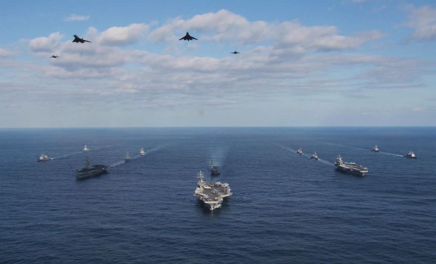
navigation market as well as in stellar-inertial   The NG Philosophy: The Hub                      or timing or both which cannot all include
and maritime navigation: NG products are                                                           anti-jam protection. As a result there can be
in use in ICBMs and on more than 60 naval          The NG approach moves the burden of             a multiplicity of self-contained GPS receivers
surface and subsurface platforms from a            trusted APNT away from sole reliance            on a single platform, leading to what Ebert
number of countries, including the USN’s           on GPS to the complementary use of              describes as “an integration and resilience
Los-Angeles-, Sea Wolf- and Virginia-class         inertial devices augmented with additional      nightmare that needs to be managed”.
submarines.                                        alternative methods of navigation. INS
                                                   calculate direction moved over time, with a     The NG solution is to harness as much of
With this background NG is well aware of           varying degree of drift, and with the use of    this sensor data as possible to contribute to
the challenge set by the need to provide           high precision oscillators provide continuity   an accurate and robust APNT solution which
APNT under all circumstances, a challenge          of time. Their great advantage is that they     will be trusted. The core of this philosophy is
accentuated by the needs of a broad user           cannot be spoofed or jammed.                    a software-defined open architecture that
base which ranges from the submarine to                                                            can affordably integrate data from diverse
the dismounted soldier, with a wide range of       On an individual platform there may be          sensors, both GPS and non-GPS, in a single
missions, requirements and constraints.            a number of sensors, each of which is           hub for distribution throughout the platform.
                                                   a potential source of complementary
Dean Ebert, vice president, navigation and         information to support navigation. For          The sensor fusion framework functions at
positioning systems, Northrop Grumman,             example, in addition to INS and celestial       both the sensor measurement and signal
                                                                                                   processing levels, providing access to the
                                                                                                   different signals and enabling multiple
                                                                                                   levels of checks on their validity. The raw
                                                                                                   information from all the relevant sensors
                                                                                                   on board the platform is available to the
                                                                                                   hub, with each additional source of data
                                                                                                   increasing resilience, adding accuracy and
                                                                                                   improving the integrity of the solution.

                                                                                                   The centralised framework for GNSS and
                                                                                                   other RF PNT signal processing which
                                                                                                   the hub provides also gives it the capacity
                                                                                                   to extract the particular signals it needs
                                                                                                   to provide APNT for a specific mission or
                                                                                                   threat environment, thus offering flexibility
                                                                                                   in creating the sensor measurements
                                                                                                   for fusion as well as flexibility in the fusion
                                                                                                   process itself.

                                                                                                   A hub solution reduces vulnerability through
                                                                                                   its use of a variety of information sources and
                                                                                                   reduces cost as it utilises existing sensors.
                                                                                                   The modular open systems architecture
                                                                                                   allows rapid reconfiguration to allow
                                                                                                   acceptance of different signals, with standard
                                                                                                   interfaces developed for individual sensors
                                                                                                   which can access a signal as early as possible
                                                                                                   to reduce the amount of processing.

                                                                                                   This common philosophy espoused by NG
                                                                                                   has a wide range of applications which are
Top Two ships in company maintain Assured PNT with a satellite and each other as                   appropriate to diverse users, but to achieve
they approach a GPS denied area                                                                    this it must be scalable and flexible and
Bottom Once in the GPS-denied zone they mutually maintain Assured PNT using                        realised in widely differing hardware.
alternative methods and provide this for a helicopter (Northrop Grumman)
                                                                                                   Integrated Systems
emphasizes that the initial response to a          systems, vision-aided navigation using EO/
GPS-challenged environment should be “to           IR and LADAR imagery sensors is capable         A good example of this approach is the
hang on to GPS for as long as possible”.           of maintaining a position of near GPS quality   USAF’s Embedded GPS/INS-Modernization
This may mean increasing the sensitivity           both on the ground and in the air through       (EGI-M) programme, for which NG was
of the GPS receiver and its antenna,               a variety of techniques, including visual       awarded a contract by the USAF to
improving its anti-jam capability or using         odometry, simultaneous localisation and         develop the technology in May 2017. The
other onboard sensors to check its integrity       mapping (SLAM) and absolute positioning         EGI-M will have a modular, open systems
as an anti-spoofing precaution. However,           (map matching).                                 architecture to support the rapid insertion
this approach can run into issues of size                                                          of new capabilities and adaptability based
and affordability so there needs to be an          There can also be several systems each          on specific platform requirements and it
alternative.                                       with its own GPS to provide either position     will incorporate the more robust military-

2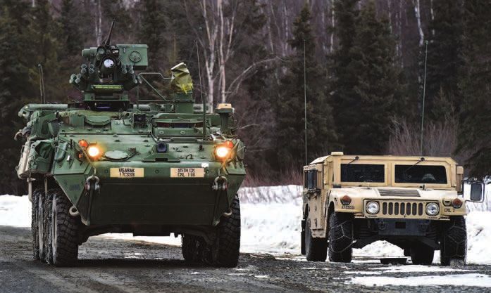
LEFT A range of sensors can contribute
to the provision of Assured PNT,
with their data fused using an open
architecture, open interfaces and
SSensors
modular software (Northrop Grumman)
Integrating the data from existing sensors
in this fashion improves accuracy and
FFuture
assurance at little extra cost.
t
As a possible future example, an F-16
equipped with a Litening targeting pod,
the software framework architecture and
an APNT distribution sensor fusion hub
might utilise all the EO/IR capabilities of
the pod to reinforce the PNT solution from
Inertial the platform’s existing GPS/INS system,
& particularly under GPS-challenged conditions.
Freq. Ref SuPPortIng SolutIonS
The modernisation of GPS satellites
to broadcast M-code requires the
modernisation of GPS receivers which
are currently hard-wired for the legacy
signal. To meet this need NG has developed
the SERGEANT software defined GNSS
transceiver. This utilises COTS processors,
allowing rapid upgrades to take advantage
of technology developments and outpace
threats, and it has advanced anti-jam
capabilities. SERGEANT’s software design
now allows it not only to access M-code
but also any satellite navigation signal,
providing significantly increased resilience
and flexibility. It has a modular architecture
and can be integrated with other systems:
code (M-code) GPS signal, which has been inertial device, a chip-scale atomic clock it has already been successfully hosted in
developed in response to the increased GPS- (CSAC) and a GPS receiver, and it will also the proven NG LN-260 INS/GPS which is in
hostile environment. EGI-M is also designed have access to existing data, such as from service with the USAF.
for compatibility with current systems on a vehicle odometer. Other sensors which
legacy aircraft. are already installed on the platform, such The flexibility of the hub approach and its
as EO/IR devices, could also be integrated scalability for use on a range of platforms is
The same approach is being taken with the into the hub to reinforce the APNT solution. reinforced by improvements NG is making
US Army’s Mounted Assured PNT System
(MAPS) programme. This will provide APNT Northrop Grumman will leverage its
data to land vehicle platforms, distributing hub philosophy for the US Army MAPS
it from a fusion hub over the standard programme, which will provide a low-cost
VICTORY electronic vehicle architecture to solution for APNT utilising all the available
any warfighting function application that data on a vehicle platform such as this
requires it. It will use anti-jam antennas Stryker IFV (US Air Force/Justin Connaher)
to improve the anti-jam margin of existing
military GPS receivers and will detect and
report GNSS interference sources. By
integrating timing capabilities and a PNT
distribution hub it will replace the need for
multiple GPS receivers on a single platform.
MAPS will be deployed in large numbers so
the solution needs to be affordable. It must
therefore rely on a different balance of
inertial and other sensors to complement
the GPS data and maintain accuracy when
it is absent. While the MAPS sensor suite
is not finally decided it is likely to include an
3
An F-16 with a Litening pod. In future the pod’s capabilities
                                                                                could be used to reinforce the PNT solution via a sensor
                                                                                fusion hub (US Air Force/Senior Airman Jorden Castalan)

to inertial systems. It is taking advantage       This development is of particular value           The NG LN-220 is a Stellar-Inertial system
of new technology to shrink size and cost         to weapon systems, where the provision            that is the latest in an evolutionary process
with the Precise Robust Inertial Guidance         of APNT in a low size, weight and power           that has seen systems shrink by 80% in
for Munitions Navigation-Grade Inertial           (SWaP) form factor will make a significant        size and weight and over 90% in power
Measurement Unit (PRIGM: NGIMU)                   contribution to weapons guidance in a GPS-        consumption. It integrates proven NG
programme funded by the US Defense                hostile environment.                              advanced inertial sensors with a star tracker
Advanced Research Projects Agency                                                                   and video processor. The result is a device
(DARPA), for which it was selected in March       There is also a new focus on stellar and          which in a GPS-denied environment suffers
2016.                                             celestial navigation as this can provide          from a drift of less than 30m in an hour,
                                                  another non-interferable alternative to           which can be corrected by the embedded
The resultant highly accurate                     GPS. Celestial navigation, which uses the         GPS if the service becomes available.
microelectromechanical systems (MEMS)-            known orbits of resident space objects
based IMU, designated the LR500, is               (RSOs), provides an absolute position fix.        “In developing these APNT solutions
only 5in3 in volume and weighs 0.35lbs,           Stellar navigation, which uses the stars          Northrop Grumman brings its world-
a 4000% improvement on some of its                and is therefore not always available, gives      class experience and innovative approach
predecessors, and it combines the best            roll, pitch and drift. These can be combined      to inertial instrument technologies and
features of current MEMS gyro technology.         with an inertial system to lower the drift        navigation systems. In particular, making
Coupled with NG’s proprietary dynamic             rate: while an inertial system by itself drifts   inertial navigation units smaller and
self-calibration (DSC) this gives a positional    as much as 9 nautical miles in 12 hours, a        lighter than ever before and introducing
drift rate near that of high end airborne         combined solution drifts by far less. Such a      software-defined open architecture-based
inertial navigation systems. A prototype at       combination of these technologies, which          systems will make a huge difference in GPS-
technical readiness level six will be available   can be used when mission-relevant, provides       denied and highly contested environments,”
in early 2019.                                    more resilient APNT.                              said Ebert.

    Northrop Grumman
    Navigation and Maritime Systems
    21240 Burbank Boulevard
    Woodland Hills, CA 91367 USA
    1-866-NGNAVSYS (646-2879)
    www.northropgrumman.com
    www.northropgrumman.com/a-pnt

4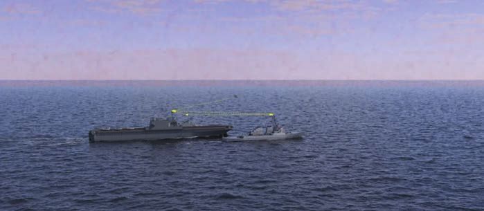
You can also read