The International Project VirtualArch: Visualization and Presentation of Hidden Archaeological Heritage Across Central Europe
←
→
Page content transcription
If your browser does not render page correctly, please read the page content below
The International Project VirtualArch: Visualization and
Presentation of Hidden Archaeological Heritage Across Central
Europe
CHRISTOPH LOBINGER and CHRISTIANE HEMKER, Archaeological Heritage Office of
Saxony, Germany

Different approaches and challenges, sharing experiences but reaching the same goal – a better understanding and
raised awareness of hidden archaeological heritage and its protection by presenting it via new information and
communication technologies like VR/AR. That is the main background of the EU-project “VirtualArch – Visualize
to Valorize”, running from July 2017 to June 2020. Ten partners from eight central European countries try to
elaborate a transnational strategy to valorize hidden archaeological monuments by visualizing them. Therefore, eight
selected pilot sites were digitized/visualized and presented to stakeholders via guided field tours and information
points on spot. The pilot sites are presenting different archaeological types, forms and periods like prehistoric and
medieval mines, roman and medieval harbors as well as cultural landscapes with prehistoric pile dwellings or urban
archaeology with huge and complex stratigraphy. This includes also different areas and environments, impacts and
audiences. Although the project is still in its first half, the session seems to be a perfect area to present project and its
actors as well as share first experiences with all present professionals and experts.

Key words:
Heritage communication and protection, VR/AR, transnational cooperation approach.
CHNT Reference:
Christoph Lobinger and Christiane Hemker. 2018. The International Project VirtualArch: Visualization and
   Presentation of Hidden Archaeological Heritage Across Central Europe.

INTRODUCTION
The rich and diverse archaeological heritage of central Europe is in parts excellently developed and utilized. But in
contrast to finds in museums, a broad share of this heritage sites, even of international importance, is very often
hardly visible and tangible for the public. Moreover, archaeological heritage is affected by different human activities
and spatial usage conflicts.
VirtualArch focuses on the practical application of innovative and trendsetting visualization tools in the field of
virtual and augmented reality [Reffat and Notfal 2013]. One of the aims is to unveil regional archaeological heritage
– located underground or submerged, partly with global importance (UNESCO) – to local and regional stakeholders
that are responsible for economic development. By tailoring and implementing of target group oriented and specially
designed visualizations and presentations using “Virtual or Augmented Reality” (VR/AR), their level of awareness
and acknowledgement will be increased [Frontoni et. al. 2015]. Furthermore, virtual reconstructions could be used
as innovative visualization tool during spatial usage conflict management and hence contributes to a better heritage
protection.
VR/AR provides not only a better accessibility to hidden or inaccessible archaeological heritage, but offers also new
possibilities for tourism, regional development, cultural participation and the usage of archaeological data in the
field of creative industries and media sector. Even virtual open-air-museums could be built [Unger et. al. 2016].

Authors addresses: Christiane Hemker, Christoph Lobinger, Archaeological Heritage Office of Saxony, Zur Wetterwarte 7, 01109 Dresden,
Germany; email: (christiane.hemker, christoph.lobinger)@lfa.sachsen.de

                                                                                                                  CHNT 23, 2018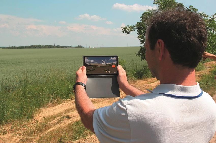
1:2      Ch. Lobinger and Ch. Hemker

PARTNERS AND PILOT SITES
Different to many other VR/AR visualization projects in archaeology, VirtualArch approaches through transnational
cooperation with different heritage. Facing similar challenges and sharing same objectives, ten partners from eight
countries get together in a EU-funded project (Interreg Central Europe), running from 2017 to 2020. The partner
consortium is composed of regional and national archaeological institutes and heritage offices, two
universities/research institutions and also two local communities as heritage owner. On eight selected pilot sites all
over Central Europe, their experiences were shared, distinct innovative visualization and communication approaches
were discussed and introduced, special applications due to the demands of each heritage and their audience
developed [Lobinger and Hemker 2018].

      Fig. 1. Pilot sites and partners of Interreg Central Europe project “VirtualArch – Visualize to Valorize”
                                    (© Archaeological Heritage Office of Saxony)

This heterogeneous approach is also reflected in the diversity of the pilot heritages, like in Fig. 1. The sites are
characterized by various archaeological cultures, areas, environments, impacts and challenges. All of these sites
contains unique finds, often from organic material like Fig. 2 which allows a huge insight of past life and procedures
and thus of international importance for research and general public. But none of them are accessible or even visible,
and because of their complex structures they are also hardly tangible especially for non-professionals.
According to their nature the pilot heritages can be separated in three groups: urban area, mines and underwater
sites. Each of these groups has its specifics, as in a way of the gathering primary data, but also in a way in which

                                                                                                     CHNT 23, 2018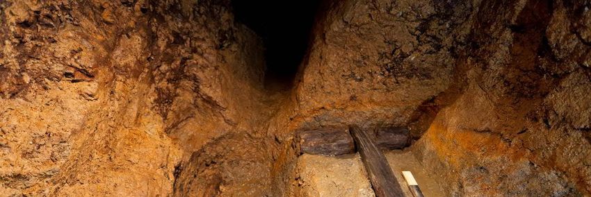
The International Project VirtualArch 1:3
they are further presented to a public. Also, each pilot site has its specifications concerning the main aim of what is
there to be achieved as a goal.
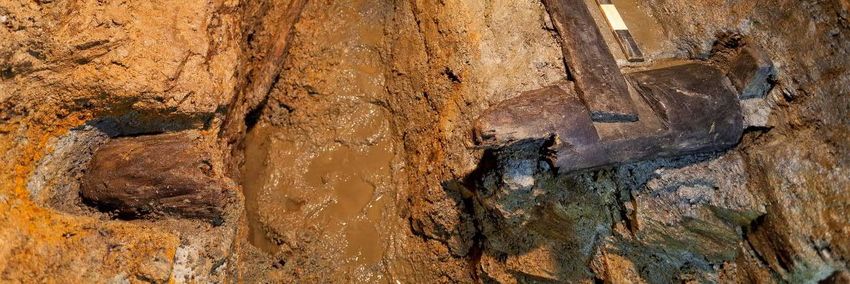
Fig. 2. Wooden parts of a winch in a medieval mine under the current town of Dippoldiswalde
(© Archaeological Heritage Office of Saxony; photo by Martin Jehnichen)
Within the group of mining heritages there are at first the prehistoric salt mines of Hallstatt (Austria), since l997 part
of the UNESCO cultural landscape “Hallstatt-Dachstein/Salzkammergut”1. Known in the scientific community for
the famous cemetery excavated in the 19th century, Hallstatt is one of the most important sites in European
archaeology, thanks to outstanding results of excavations and experimental researches undertaken by the Natural
History Museum Vienna since the 1960s in the still active salt mines [Reschreiter et al. 2018]. Nowadays, the Salt
Valley is already a popular tourist destination with a good infrastructure, so the aim in this project is to develop more
precise and attractive ways of presenting the finds or to show them in a new light for the public. On the other hand,
the heritage is threatened seriously by natural movements of the rock itself [Reschreiter et al. 2017].
1
https://dachstein.salzkammergut.at/en/world-heritage-hallstatt-dachstein-salzkammergut.html
CHNT 23, 2018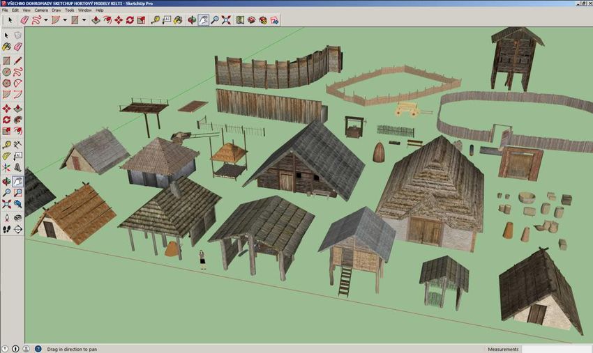
1:4      Ch. Lobinger and Ch. Hemker

            Fig. 3. Survey and digitization of prehistoric mines in Hallstatt (© Natural History Museum, Vienna)

The second important mining heritage is located in Saxony (Germany), where unique and almost complete mines of
the Middle Ages were found under the Town of Dippoldiswalde. As part of the “Erzgebirge/Krušnohoří mining
region” (Ore Mountains), the Dippoldiswalde medieval silver mines recently achieved UNESCO World Heritage
status2. Since 2008, the Archaeological Heritage Office of Saxony records and recovers this outstanding heritage
[Hemker 2011; Hemker and Schubert 2018], which is – due to security reasons – not accessible and visible for non-
professionals or tourists.
Another big mining landscape was in the mountainous area around Civezzano (Italy) near Trento. Especially from
the 12th to the 15th century silver ore was exploited there intensively so archaeologists discovered a mining area
with sinkholes and gallery entrances over 12 km2 [Casagrande 2013]. Due to security reasons they are not accessible
and threatened itself by agriculture and forestry.
A big and important mining and metallurgic settlement from the 13/14th century next to visible mining relicts was
discovered near Utín in the Bohemian-Moravian highlands [Derner et al. 2016]. The settlement, mostly known
thanks to geophysical surveys, includes interesting features like miners' houses, ore mill, a stamping mill or furnaces
as well as a hospice and a filial chapel. The area is nowadays rarely inhabited but agriculture and especially forest
activities could endanger this interesting site. Identifying in its full extend, virtual reconstructions and target group
oriented lectures and tools enables a better understanding and consequently protection, for example by creating
special exclusion zones.
Urban archaeology is represented by the pilot site Nitra (Slovakia) which was a princely residence since the 9th
century) and is of national importance as oldest center of early Christianity [Fusek and Bednár 2008]. The urban
area of Nitra was settled since the Neolithic period. The settlement layers and layers of rebuilding made the
archaeological localities invisible to the visitors´ eyes. Here, mainly the excavations done since 30 years by the
Slovac Acedemy of Sciences as well as small finds will be visualized to present the importance of the site from the
smallest detail like a tiny cup to the big picture [Ruttkay 2011].

2
    https://www.montanregion-erzgebirge.de/en.html

                                                                                                        CHNT 23, 2018
The International Project VirtualArch                   1:5

In contrast to the latter example, the Slovenian pilot region3 is a large wetland area near Ljubljana containing several
prehistoric pile dwellings, since 2011 UNESCO World Heritage.
.The pile dwellings are a tremendous source of information not only for archaeology, but also for dendrochronology,
botanic, climatology, geology and other fields of interest. The preservation of this archaeological heritage of a global
importance is however heavily endangered. Ljubljansko barje constitutes a very attractive area from agricultural
land‐use point of view and is therefore highly endangered by the interventions of the local farmers e.g. building new,
deep drainage channels and deep ploughing. Interactive landscape history visualizations and AR applications
showing the nowadays invisible settlement structures should sensitise the stakeholders for a better protection.
Finally, the special field of underwater archaeology is represented by two important harbors: First, we have the
ancient roman harbor Barbir in Sukosan, located at the Adriatic Sea coast of Croatia. There are several submerged
stone structures as remnants of piers or breakwaters as well as pottery and small finds from the 3rd to 4th century.
Although the International Centre for Underwater Archaeology is seated in near Zadar, only few research and
surveys were conducted and the site is almost unknown to the public. Second, a large site from the 10th to 14th
centuries in the Baltic Sea is known offshore of the Polish town of Puck [Pomina et al. 2016]. Over an area of 12
acres several remains of the harbor construction, 4 shipwrecks, potsherds and bones from the 10th to the 14th
century were found. Puck was probably the largest early medieval port in the southern Baltic Coast, bigger than
well-known places like Haithabu, Schleswig or Lübeck.

FROM 3D SURVEYING TO VIRTUAL MODELS
Although the differences between the heritage sites, the activities in the pilot regions are based on a same multi-
stepped strategy:
First, all partners were gathering and digitize data of the archaeological pilot heritages like in Fig. 3, including field
surveys and aerial reconnaissance. Finds and archaeological features were 3D recorded via different techniques
ranging from structure-light scanners to photogrammetry and 3D scanning of finds4 as well as hydroacoustic survey
methods for the underwater sites.
The obtained and processed data provides the base for modelling of the virtual reconstructions as the second step.
Depending on the visualization options and the “storytelling” behind it, the high resolution meshes have to been
reduced, missing items added or situations and textures exchanged, like Fig. 4.
In the third step the result – the almost realistic virtual model of a heritage – will be visualized via various VR/AR
options. During the year 2018, project partners met together as well as with other interested parties (external experts,
stakeholders etc.) to create a coherent vision for digitalization and visualization of the pilot sites. This contains
interactive panorama views of e. g. prehistoric or medieval settlements which are now invisible under the current
construction of modern town or under the surface of farmland like in Fig. 5. Interactive 3D models of small finds or
even whole landscapes allow a better understanding of the subject. With AR methods, users could walk virtually
through past settlements and mines directly on resp. over the heritage site. Finally, new VR data glasses enables
immersive experience of inaccessible sites using “ancient items” which are normally hidden in archives or exhibited
in showcases of archaeological museums.

3
    https://www.palafittes.org
4
    For the mining archaeology see for example [Göttlich and Reuter 2013]

                                                                                                         CHNT 23, 2018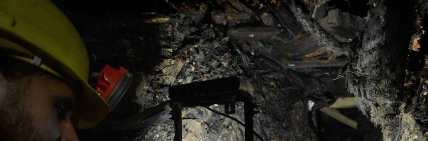
1:6      Ch. Lobinger and Ch. Hemker

   Fig. 4. Virtual reconstruction of a medieval mine based on archaeological surveys and digital documentation
                     methods (©Archaeological Heritage Office of Saxony; image by Jiři Unger)

VIRTUALARCH MOBILE APPLICATION FRAMEWORK
To understand the heritage, its background and to discover several “points of interests” in hardly visible heritage
landscape, these special applications were provided through a developed transnational mobile app with information
texts, pictures, videos and interactive maps about the heritage.
Programming an app is expensive; keeping the content up-to-date furthermore requires regular updates which add up
to the running costs. Furthermore, the diversity of the pilot monuments and local realization concepts make “one
App” almost impossible. In our work for the EU Project VirtualArch, we have thus sought a way in which each
partners can cross certain technical barriers and produce a location-based App without need for programming or
external consultancy.
Therefore, we have produced a portal which allows for each pilot site the upload of a zip file containing a range of
media (images, text, 3D files, panoramas, movies) in one or more folders; each one is transformed into a point of
interest on a map for which the associated media can be shown as a slideshow. The key strength of the approach lies
in the fact that the portal can produce both web presentations as well as apps using the same content. Technically
this is achieved via the use of rules for transforming the content into html/css + javascript, and Apache
Cordova/Adobe PhoneGap for turning the resulting web page into an app. Concerning individual wishes links to
supplementing applications with VR/AR content are possible. With this portal and immersive visualizations tools
partners now have the possibility to disseminate their often complex research, archaeological relevance of their
heritage and detailed protection objectives frequently to a wider public using only smartphones.

                                                                                                   CHNT 23, 2018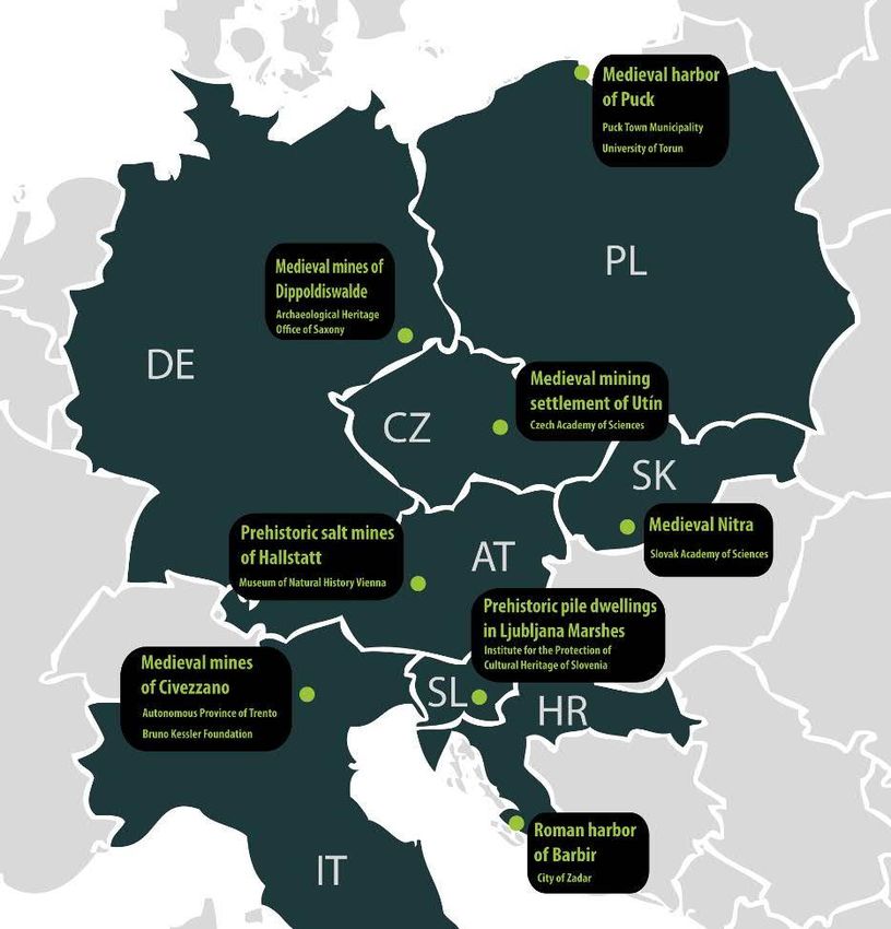
The International Project VirtualArch        1:7

  Fig. 5. Making visible the invisible via VR/AR mobile applications (© Archaeological Heritage Office of Saxony)

IMPLEMENTATION, COMMUNICATION AND ENHANCING CAPACITIES
Archaeological stakeholders of the partner territories will be involved in the planning and implementation of the
pilots and the evaluation of their success. Workshops and guided field trips are offered to them to learn more about
the existing heritage and raising their awareness, especially in case of heritage threats and protection conflicts.
Beside, workshops and conferences about related topics – archaeology & tourism, public archaeology, archaeology
& agriculture or usage of archaeological data in media sector – bolster the knowledge of all partners and capitalize
good practises (for upcoming events, see https://www.interreg-central.eu/VirtualArch).
For a better physical appearance and access, especially other audiences like tourists or local communities, the
partners realize further smaller investments such as information boards with basic heritage information or WiFi
hotspots providing internet access for free app downloading on their own devices. QR codes links to digital data,
markers open 3D model in the various AR applications. Beside conventional communication methods, users could
experience archaeology on a complete new way. Due to this valorization of heritage, both regional identity and
cultural participation could be enhanced boosting also local tourism and regional development.
But not only non-professional locals and tourists should learn about their “heritage”, also future generations like
students, young researchers and specialists from the fields of archaeology and related subjects have the opportunity
to be involved and increase their knowledge in virtual archaeology and their methods in an upcoming (and free of
charge) summer school in June 2019, organized by Partners in Torun (Poland).
Based on the experiences in these pilot regions a transnational strategy for future projects as well as guidelines for
similar heritage sites will be worked out. In addition, the development of a free accessible visualization home kit is
planned providing existing 3D models including detailed information about find spot, age determination,
chronological and regional occurrence as well as the important question about accuracy of virtual reconstruction.
Users, especially small actors like local museums, could utilize these models as base for their own small-budget
visualisation projects (building-block principle) following the strategies of VirtualArch.
Archaeological heritage and the sharing of knowledge about them is a public matter carried out by different regional
and national archaeological institutions. VirtualArch enhance this duty by introducing and promoting VR/AR
approaches as possible new path in communication and protection of our cultural heritage.

                                                                                                     CHNT 23, 2018
1:8 Ch. Lobinger and Ch. Hemker
Fig. 6. Different components for a virtual reconstruction of an early medieval settlement, based on modular
principles (© Institute of Archaeology of the CAS, Prague)
CONCLUSION
One of the important contributions of the VirtualArch project is the implementation of cultural mediation, as one of
the central tasks of archaeological heritage. By using modern IT technologies hidden or inaccessible archaeological
sites and areas such as mines, harbors and settlements become virtually accessible to various interest groups. Even
complex facts and reconstructions were presented understandably by the applied VR and AR technologies directly
on site. Beside this, coming from eight European countries and different institutions dealing with archaeological
heritage matters, all project partners create a broad base of experience and promote the international exchange of
scientific, strategic, legal and methodical information. As a result of the cultural mediation, the public awareness for
these "nonvisible" archaeological places will increase; the heritage offices will be able to reconstruct sites i.e. for
stakeholder meetings (conflict management). At the end of the project the applied VR and AR technologies
explained by the guidelines will be open not only for heritage or archaeological institutions but as well for tourism
offices or local museums to promote and protect their archaeological heritage in their region.
REFERENCES
Lara Casagrande. 2013. Mining landscapes in the Province of Trento (north-east Italy): new technologies for
research and preservation. In Regina Smolnik, eds. ArchaeoMomtan 2012. Erkunden – Erfassen – Erforschen.
Dresden: Arbeits- und Forschungsberichte zur sächsischen Bodendenkmalpflege, Beiheft 26, 39-43.
Kryštof Derner, Petr Hrubý, and Matthias Schubert. 2016. Mittelalterliche Silberproduktion im wettinischen und
přemyslidischen Regierungsraum: Neue archäologische Untersuchungen. Der Anschnitt 69, 216-241.
Emanuele Frontoni, Eva Savina Malinverni, Roberto Pierdicca, and Primo Zingaretti. 2015. Making Visible the
Invisible. Augmented Reality Visualization for 3D Reconstructions of Archaeological Sites. In Yevgeniya
Daineko, Madina Ipalakova, Viktor Dmitriyev, Andrey Giyenko & Nazgul Rakhimzhanova, eds. 3D Physics
Virtual Laboratory as a Teaching Platform. AVR 2015. Lecture Notes in Computer Science, vol 9254, 25-37.
CHNT 23, 2018The International Project VirtualArch 1:9
Gabriel Fusek and Peter Bednár. 2008. Die (vermutete) Kirche am Burgberg von Nitra (Slowakei). In Martina
Pippal and Falko Daim, eds. Die frühmittelalterlichen Wandmalereien Mährens und der Slowakei. Innsbruck:
Monographien zur Frühgeschichte und Mittelalterarchäologie 12, 31-46.
Fanet Göttlich and Thomas Reuter. 2013. Methoden der grabungsbegleitenden 3D-Dokumentation. In Regina
Smolnik, eds. ArchaeoMomtan 2012. Erkunden – Erfassen – Erforschen. Dresden: Arbeits- und
Forschungsberichte zur sächsischen Bodendenkmalpflege, Beiheft 26, 209-223.
Christiane Hemker. 2011. Archäologie in Dippoldiswalde. In Regina Smolnik, eds. Aufbruch unter Tage. Stand und
Aufgaben der montanarchäologischen Forschung in Sachsen. Dresden: Arbeits- und Forschungsberichte zur
sächsischen Bodendenkmalpflege, Beiheft 22, 117-126.
Christiane Hemker and Matthias Schubert. 2018. Silber aus dem Erzgebirge. Archäologie in Deutschland, Heft
5/2019, 8-13.
Christoph Lobinger and Christiane Hemker. 2018. Wie präsentiere ich mittelalterlichen Bergbau? Das EU-Projekt
VirtualArch und der Einsatz von virtueller Realität. Archaeo 15, 2018, 32-35.
Iwona Pomina, Błażej Śliwiński, Szymin Uścinowicz, and Tomasz Wa żn y. 2016. The remains of the medieval
harbour in Puck (Northern Poland): a few words about the results of previous research. Archaeologia Abltica 23,
235-243.
Rabee M. Reffat and Eslam Nofal. 2013. Effective communication with cutlural heritage using virtual technologies.
In International archives of the photogrammetry, Remote sensing and Spatial Information Sciences 40-5/W2,
2013, 519-524.
Hans Reschreiter, Kerstin Kowarik, David Ottowitz, Alexander Römer, Rohn Joachim, Franz Ottner, and Michael
Grabner. 2017. Alles in Bewegung - Massenbewegungen und der prähistorische Salzbergbau in Hallstatt. In:
Exkursionsführer zur Arbeitstagung "Angewandte Geowissenschaften an der GBA", Bad Ischl, Hallstatt,
Gmunden, 153-160.
Hans Reschreiter, Fiona Poppenwimmer, Daniel Brandner, and Gabriel Wurzer. 2018. Weltkulturerbe konserviert im
Salz. Archäologie in Deutschland, Heft 3/2018, 62-63.
Matej Ruttkay. 2011. Moznosti prezentácie zaniknutych kostolov v Nitre na Martinskom vrchu. In Ranostredoveká
sakrálna architektúra Nitrianskeho kraja. Nitra. 59-68
Jiří Unger, Luboš Jiráň, and Petr Vavrečka. 2016. Neue Möglichkeiten zur Rekonstruktion archäologischer Objekte.
Fines Transire 25, 1-9.
Imprint:
Proceedings of the 23rd International Conference on Cultural Heritage and New Technologies 2018.
CHNT 23, 2018 (Vienna 2019). http://www.chnt.at/proceedings-chnt-23/
ISBN 978-3-200-06576-5
Editor/Publisher: Museen der Stadt Wien – Stadtarchäologie
Editorial Team: Wolfgang Börner, Susanne Uhlirz
The editor’s office is not responsible for the linguistic correctness of the manuscripts.
Authors are responsible for the contents and copyrights of the illustrations/photographs.
CHNT 23, 2018You can also read