TIM - Telematic International Mission - A Regional Leaders Summit (RLS) supported space project - Zentrum für Telematik eV
←
→
Page content transcription
If your browser does not render page correctly, please read the page content below
TIM - Telematic International Mission
  A Regional Leaders´ Summit (RLS) supported space project

                               Newsletter 2020
The Telematics International Mission (TIM) is a multinational effort to combine multiple nanosatellite
mission in a larger formation, aiming at different remote sensing applications. In TIM, institutes from
around the world join by contributing with their own satellite formations and ground infrastructure.
In TIM project, partners from the Regional Leader Summit (RLS) of partner states from 5 continents,
cooperate under the technical leadership of Zentrum für Telematik e.V.

Editorial
The 2016 Regional Leaders Summit selected as one of
their joint scientific projects TIM – the Telematics
International Mission, a small satellite formation for
Earth observation. TIM takes advantage that all RLS-
partners have outstanding capabilities and expertise in
space technologies. By combining them, challenging,
innovative Earth observations with CubeSats are
addressed. The TIM formation of cooperating small
satellites extends joint RLS projects even to space, and
enables acquisition of Earth observation data for
improved monitoring of agriculture, emergencies and
pollution. The partners started at different speeds, but
the impressive 10th RLS-meeting at the Brazilian Space
Agency INPE 2019 displayed in workshops and
meetings the achieved progress and motivated the
                                                           Figure 1 Artist's view of the TOM Formation combining
next steps. The partner contributions to space and         joint observations from different perspectives to 3D
ground segment of TIM were consolidated, leading to        images.
an envisaged launch of the satellites in 2021. We are      now all very excited to see our initial ideas
materializing in real space hardware.

This newsletter intends to provide a survey of the current state of TIM at all partner sites, as well as to
summarize the already achieved technology progress and to point out future application perspectives
for this joint international RLS-effort.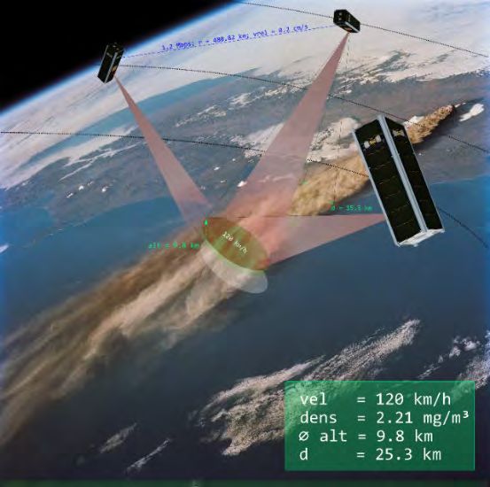
Motivation                                          The TIM Ground Station
TIM will primarily focus on Earth observation       Network
using a nanosatellite formation. This enables
observation of target areas on the Earth’s          International collaboration and technology
surface from different perspectives. Three-         exchange is a significant focal point for TIM as
dimensional surface maps can this way be            outlined above. With an aim to foster
generated by photogrammetric methods. The           collaboration and resource sharing, TIM
TIM formation, thereby, presents solutions to       partners also envisaged a Ground Station
cutting edge problems such as the identi-           Network (GSN) across RLS member states such
fication of sea vessels, monitoring thermal         that all satellites will have increased obser-
anomalies or 3D earth observation. The latter       vability and ground resources will have lower
is particularly interesting for measuring the       downtime. Payload and telemetry data will also
height of (ash) clouds, to determine their          significantly increase benefitting all parti-
motion. The suggested concept will perform          cipating institutes. The first steps in the di-
Cloud Top Height (CTH) as well as cloud ascent      rection of establishing the GSN have been ini-
velocity using photogrammetry. The approach         tiated in Würzburg. An Internet of Things (IoT)
is shown to provide results with a resolution       and web technology based concept has been
comparable to LIDAR.                                proposed. The network will demostrate
                                                    integration of heterogenous software and
                                                    hardware as well as sophisticated scheduling
Current Status and Latest                           algorithms. It will also support exchange of
Developments                                        technical knowhow as well as possibilites of
                                                    data fusion for Earth Observation. Partners in
During the last RLS Meeting, it was agreed to       Shangdong, Brazil, South Africa, and Canada
launch the first satellite formation in Q1 2021.    have already joined collaboration with
At the time of writing the Chinese partners         information about their ground stations. Based
from Shandong as well as the Bavarian partners      on the latest information from partners, the
from Würzburg will contribute a formation of        various ground stations have been mapped in
three 3U Satellites each. The 6 Satellite for-      Figure 3, showing a good distribution in
mation will perform stereoscopic earth ob-          latitude and longitude. Soon, testing of the first
servation. The development of the Satellites is     iteration of the network will be initiated. The
currently in progress. The additional RLS-          University of Würzburg with support from ZfT
partners will support the mission by com-           is coordinating the development and testing
ponents and development. Additionally further       activities.
mission ideas exist. In order to support the sa-
tellite mission and use the benefit of the global
coverage of partner institutes, a ground station
network was established.

The following sections will first outline the
ground station network before the individual
RLS-Partner mission and the current state of
                                                    Figure 2 Communication channels in TIM
development are covered.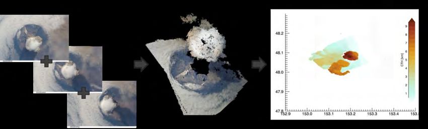
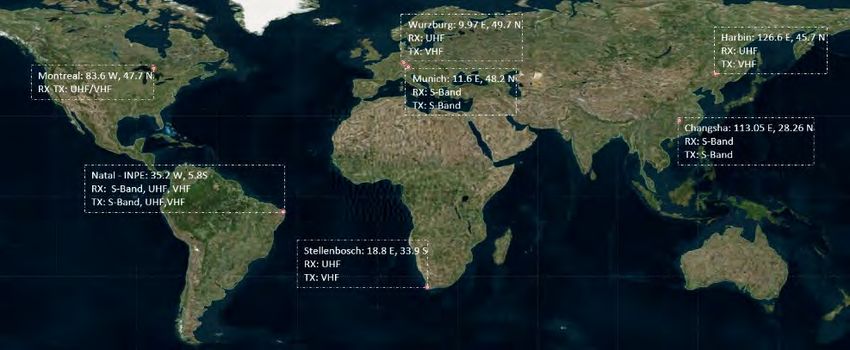
Figure 3 Ground Stations of the TIM Network

Relevant to the GSN is also the planned              will play an important role in the future
communication channels in TIM as depicted in         commercial application of the technology.
Figure 2. The UHF Band is used for TT&C and
                                                     Design of the Chinese TIM-Satellites
low speed data transfer. The Inter-satellite link
                                                     The Chinese participation in the TIM project
(ISL) will also operate in UHF. S-Band is used for
                                                     includes three satellites, the satellites are
high speed downlink of the payload data.
                                                     named TIMS-A/B/C. They are composed of
Additionally, OSIRIS is an experimental optical
                                                     identical hardware, adopting the standard 3U
downlink that is a used on the German TOM
                                                     CubeSat structure (the envelope size of the
satellites for payload data downlink.
                                                     satellite is 370mm x 130mm x 120mm). Each
The Chinese Formation from Shandong                  satellite weighs approximately 5 kg, and the
The TIM project is strongly supported by the         satellite system design life is 1 year. The TIM
Shandong Provincial Government of China, and         satellite system is composed of a satellite
has been established as a major scientific and       platform and payload system. The satellite
technological innovation project in the              platform includes the structure and thermal
Shandong Province, China. The Shandong               control subsystem, integrated electronic sub-
Institute of Space Electronic Technology (SISET)     system, power subsystem, measurement and
in Yantai received funding from Shandong             transmission subsystem, attitude control sub-
government to contribute 3 small satellites to       system and propulsion subsystem. The payload
the TIM project. The three cube satellites are       is a visible light camera to achieve ground
named TIMS-A / B / C.                                imaging. The basic block diagram of the sa-
                                                     tellite system is shown in Figure 4.
The Chinese satellites of the TIM will obtain
general information about the ground area as                                                                                                                                    Satellite System
well as altitude information, e.g. in case of
severe disasters such as volcanoes and                                                                Platform System                                                                                                 Payload System
tsunamis. This will be achieved by observing
the same target on the ground from different
angles. This method can replace the traditional
                                                                                                                                                                                    Structure and Thermal Subsystem
                                                                                        Measurement and Transmission Subsystem
                                                      Integrated Electronic Subsystem

                                                                                                                                 Attitude Control Subsystem

large-satellite ground measurements, with a
                                                                                                                                                              Power Subsystem

                                                                                                                                                                                                                           Camera

comparable resolution. Through on-orbit
operation of the TIM satellite, the feasibility of
Structure From Motion (SFM) photogrammetry
technology on small satellites will be shown
and the achievable accuracies verified, which        Figure 4 System overview of the Chinese TIM satellite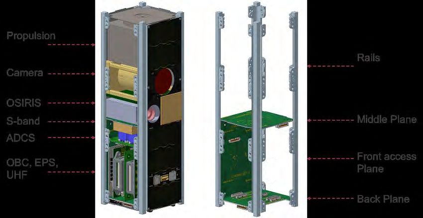
The integrated electronic subsystem includes
the central computer and navigation system. It
is the key part for the satellite’s reliability and
lifetime. The satellite measurement and
transmission subsystem is composed of UV-
satellite-ground measurement and control
device, UHF inter-satellite measurement and
control device, and X-band data transmission
device. The attitude control subsystem consists
of attitude measurement devices, attitude             Figure 6 Three main areas of satellite

control devices and attitude control algorithm.
                                                      Contact Person:
The propulsion subsystem uses micro-cathode
arc thruster, which has the advantages of small
                                                                                      Zhang Zhongzheng
size, high specific impulse and large thrust,
                                                                               zhangzhongzheng@live.cn
which can meet the requirements of the TIM
formation. The Chinese TIM satellites adopt
the standard 3U CubeSat structure & design,
and use the 3U cube standard ejection                 The Bavarian TOM-Formation from
mechanism to separate from the launch                 Germany
vehicle. The basic configuration of the satellite     The state of Bavaria sponsors the 3 formation
is shown in Figure 5.                                 flying small satellites of the Telematics earth
                                                      Observation Mission (TOM), which is
                                        Y
                                                      developed at the
                                                      ZfT in cooperation
                                                      with the University
              X                                       of Würzburg. TOM
                                                      follows on the
                                                      steps of NetSat and
                                            Z         the UWE satellite
                                                      family developed
Figure 5 Configuration of Satellite
                                                      previously at Zft
                                                      and the University
The satellite structure is divided into three         of Würzburg, re- Figure 7 Mission Badge of the
                                                                             Telematics earth Observation
main areas according to function, as displayed        spectively. In TOM Mission (TOM)
in Figure 6. The first is the payload compart-        three nano-satelli-
ment, including the camera and electric pro-          tes carrying cameras in the visible range track
pulsion unit. The second area is the electronics      and perform simultaneous measurements
stack, including the satellite’s integrated elec-     from different perspectives of the same target
tronic subsystem, the measurement and trans-          on the surface of the Earth. These observations
mission subsystem, and the power subsystem.           form the basis to apply photogrammetric ap-
The third area is the attitude control compo-         proaches for sensor data fusion to generate
nent and includes gyro, reaction wheels, sun          three-dimensional images of the target area
sensors and magnetorquer.                             (the concept is outlined in Figure 8). The
                                                      satellite platform will be based on a 3U-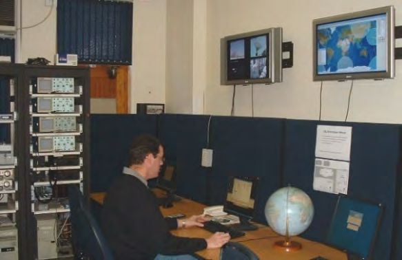
Figure 8 Multiple Pictures taken from different angles are processed to a 3d image, which can be used for CTH analysis

Cubesat design that extends the modular                            module for UHF is GomSpace’s NanoCom
design that was already successfully demon-                        AX100 2, which offers Ax25 support. The trans-
strated on UWE-3, allowing for quick and fle-                      mitter for S-Band will be provided by Iq-
xible integration. This concept has been                           Spacecom’s Hispico transceiver3. This provides
elaborated into an electrical interface standard                   a payload data rate of up to 1.6Mbps. It re-
and is promoted by UNISEC Europe 1, and will                       quires a specific receiver for ground stations.
be supported in TIM-satellites in order to pro-
vide compatibility of components and sub-
systems between the partners. The standard is
optimized for rapid integration and testing,
thus reducing development time frame.

TOM-Satellite Design
The preliminary pico-satellite system design of
the TOM Satellite is shown in Figure 11. The Sa-
tellites will be built in 3U configuration. The
main payload will be an optical sensor. Most
likely the SCS Gecko Imager. The com-
munication is split in UHF, which will be used
for TT&C as well as ISL and the payload data
downlink in S-Band (MHz). The communication

                                                                         Figure 9 Orbit design of the TOM Formation

                                                                   Additionally, one of the TOM satellites houses
                                                                   an optical link to the ground, demonstrating
                                                                   the capability of a high-bandwidth. One of the
                                                                   main challenges of TOM is the formation flying
                                                                   technologies for the coordination of the three
                                                                   TOM satellites to perform joint observations.
                                                                   The technology base focusses on networked
Figure 10 Flat-Sat Setup for easy Test & Development of
Satellite Subsystems

1
 http://unisec-europe.eu/standards/bus/                            3
                                                                       https://www.iq-spacecom.com/products/hispico
2
 https://gomspace.com/shop/subsystems/communi
cation-systems/nanocom-ax100.aspx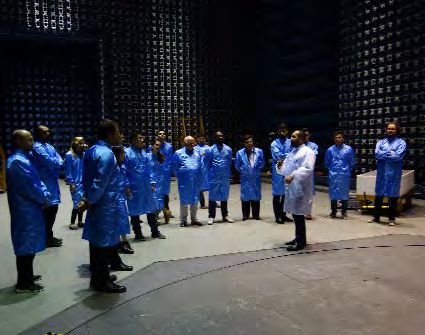
Figure 11 preliminary TOM Satellite Design

control algorithms, using inter-satellite links      Visual servoing
and relative navigation approaches. In this          An additional goal of TOM is the demonstration
context particularly challenging is the attitude     of a novel method for improving satellite at-
and orbit control system at the size of a 3U-        titude control by visual servoing, which calcula-
CubeSat to realize appropriate pointing ac-          tes features of camera images on-board. This
curacy. For this purpose, miniature reaction         also serves as input precision for fine pointing
wheels have been developed with specific high        of the control systems. The formation will con-
rotation speed as essential element of the           sist of at least 3 German TOM satellites. One of
attitude control system. The propulsion system       the satellites will be
used in TOM is the IFM NANO thruster by En-          configured as the master.
pulsion 4. They are currently tested in one of       Its task is to detect, de-
ZfT’s other missions. A Flat-Sat setup is shown      scribe and continuously
in Figure 10.                                        track features. It will also
                                                     transmit this information
Orbit & Formation design for TOM
                                                     in form of descriptors to
In order to meet the project goals of achieving                                   Figure 12 Satellite
a comparable performance to Lidar by photo-          the slave satellites. After Formation for Visual
grammetric measurements, it is necessary to          receiving the descriptors, Servoing
achieve a vertical precision of ca 200m.             they will detect and describe the features as
However, TOM aims to provide results with            well. Then a matching between Slave and
20m precision, which make possible to mea-           Master Descriptors is performed. And the ma-
sure also the vertical speed of the clouds. In ac-   tched features are tracked by the slave
cordance with the above requirements, the fol-       satellites as well. The Procedure is outlined in
lowing orbit design was done: The three TOM          Figure 13.
satellites form a triple pendulum formation
with a baseline of ca 100km. The out of plane        Contact Persons:
separation is about 50km in order to improve                                  Prof. Dr. Klaus Schilling
the coherence of the imagery data. The quality                klaus.schilling@telematik-zentrum.de
of results depends mainly on the ratio between                               Alexander Kleinschrodt
baseline and satellite altitude. Such triangle                   alexander.kleinschrodt@telematik-
formation provides more stable results than a                                             zentrum.de
string of pearls in across track direction.

4
    https://www.enpulsion.com/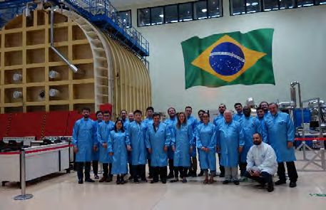
Figure 13 Visual Servoing tasks of Master and Slave Satellites

The Assembly Integration and Test                                including the need for a constellation of at least
(AIT) in São Paulo, Brazil                                       four nanosatellites, using active attitude
The test centre LIT (Laboratory of Integration                   control to change the imaging targets. The
and Testing), in São José dos Campos, is part of                 second proposed mission applied to the mete-
the Brazilian Institute for Space Research                       orological area consists of cloud-forming ob-
(INPE) and hosts impressive facilities for func-                 servation mainly present in the tropics. A sa-
tional and environmental satellite tests. In                     tellite formation was proposed for collecting
2019 INPE hosted the 10th RLS Meeting, during                    data to estimate the vertical velocity of clouds.
which the TIM project meeting took place. LIT                    These experimental data are necessary to im-
can be used for Assembly, Integration, and                       prove existing numerical models from CPTEC,
Testing (AIT) of nanosatellites and it offers                    and weather forecast. These conceptual mis-
support and engineering consulting for the                       sions could be a contribution to future Small
elaboration of the AIT plan. Mass and physical                   Satellites-RLS projects.
measurements can be performed, which e.g. is                     Contact Person:
important for precise attitude control. Clean-                                         Prof. Dr. Geilson Loureiro
rooms (ISO 7 and ISO 8) are also available for                                                geilson@lit.inpe.br
assembly and integration. Further test facilities
include: thermal and thermal-vacuum tests;
dynamic tests; electromagnetic compatibility
tests. LIT also offers support in logistic and
operation for these different activities. As a
contribution from the São Paulo region mission
to TIM and the Small Satellites-RLS, the group
at the Laboratory of Concurrent System Engi-
neering (LSIS) from LIT began in 2019 two con-
ceptual missions studies, based on the needs of
the Meteorology (CPTEC) and Earth Obser-
vation (OBT) areas from INPE. The first
proposed mission is a Brazilian Constellation
for Eart-Observation, able to work jointly with
CBERS 4, CBERS 4A, and Amazônia -1 (Brazilian
satellites) data. It aims to support the identi-
fication of rain forest fires with more accuracy
and to avoid false alerts. The constellation
would provide several advantages, mainly the
availability of images with high temporal and
spatial resolution, in the Brazilian Amazon re-
gion. A preliminary analysis was carried out to
establish the main mission requirements,
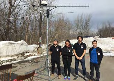
Image data processing -Quebec, Canada                  acceptance rate for the program is expected to
The team in Quebec will provide support in two         be very low. In Québec the project has been
areas: (1) Offline data processing: once the           discussed in several occasions, and Québec has
data are received through the network of               hosted the 2018 TIM project meeting. Quebec
ground stations, they need to be analysed for          has funding for one satellite without payload
3D reconstruction and to extract relevant infor-       and launch. Furthermore the Quebec will sup-
                                                       port TIM with their Ground station as soon as it
                                                       is installed and functional.

                                                       Contact Person:
                                                                                 Dr. Giovanni Beltrame
                                                                         giovanni.beltrame@polymtl.ca

                                                       Ground Station Support from Western
                                                       Cape, South Africa
                                                       South Africa did not receive any government
Figure 14 The student team at Polytechnique with the   support, despite the innovative satellite miss-
Ground Station Antenna                                 ion they wanted to realise in the frame of TIM.
                                                       However Stellenbosch University will still
mation. The team at CRIM and at Polytech-              contribute with support via Ground Station.
nique have long experience in the processing of
large-scale geometric data and will use recent         Contacts Persons:
algorithms and the resources of CalculQuebec                                       Prof.Dr.Herman Steyn
to perform the data analysis. The results will be                                    whsteyn@sun.ac.za
                                                                                   Prof.Dr.Robert van Zyl
shared with the rest of the team. (2) The team
                                                                                     vanzylr@cput.ac.za
at Polytechnique has developed visual-based
coordination strategies for multi-robot
cartography. These strategies can be applied to
provide masterless visual servoing, with peer-
to-peer communication and collective decision
making for a group of satellites. The team will
therefore assist in the software development
and testing for the visual servoing part of the
project. The team is also in talks with a
company to start a local research project for
the use of decentralized control for multi-
satellite systems. The company would provide
a visually accurate 3D simulator that can be
used to validate visual servoing, co-
mmunication, and coordination strategies. The
collaboration with a local company would open
the doors for the team to acquire much needed
additional funding, as it is a requirement from
both federal and provincial agencies to have a
minimum of 20% cash contribution from
industry for most funding opportunities.
                                                        Figure 15 Ground Station at the Western Cape,
Another substantial funding opportunity is
                                                        South Africa
available from the federal government (the
Alliance program). The team will apply, but the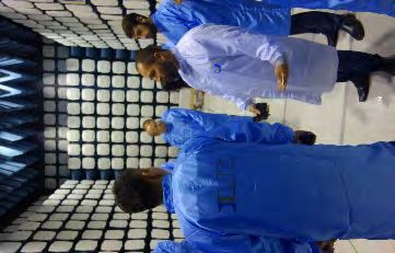
Project Timeline
The official Launch Date for the TIM Formation
was agreed to be in Q1 2021. This will probably
mean that not every partner can participate
with an own implementation of a satellite
system. Local government requires us to finish
the already started project in timely matter.
Still cooperation and involvement of all RLS-
partners is done, e.g. by the actions outlined in
the following: 1) by sharing developments: e.g.,
sharing of components has been a huge part of
the project from the beginning, the joint
UNISEC bus enables the easy swapping of
components. 2) Providing access to testing and
building facilities for testing, integration as well
as qualification. 3) Most important is the
support of the Mission by joining the individual
partner’s ground station to the TIM network.

Future Perspectives                                     Figure 16 Impressions from the RLS-Meeting'19 in
                                                        INPE, Sao Paulo, Brasil
The next technology step following TIM will be
application of more elaborated data fusion and         The next RLS meeting in 2020 was scheduled to
formation flying techniques to Earth ob-               take place in Linz, Austria. Due to the recent
servation. Thus, on basis of TIM technologies          pandemic this will be shifted to 2021. However
the highly reputed ERC Synergy Grant                   as a replacement this year’s meeting will be
“CloudCT” was awarded to the Israeli-German            held virtually. For more up-to-date informa-
team of the professors Schechner, Koren and            tion, please consult the RLS-Sciences website:
Schilling in 2018, to characterize the interior of     https://www.rls-sciences.org/
clouds by generating 3D-images.

                                                       Further Information
Meetings                                               Further information about the Small Satellites
Meetings take place regularly during Regional          project within RLS-Sciences can be found on
Leaders Summits in partner countries.                  the TIM website:
                                                       https://www.rls-sciences.org/small-
•    In 2016, TIM has been presented at the
                                                       satellites.html
     8th RLS conference in Munich, Bavaria.
•    In 2017, a dedicated TIM meeting was              The Project website can be found on:
     organized in Würzburg, Bavaria.                   https://rls-smallsatellites.org/
•    In 2018 during the 9th RLS in Quebec-City         The Zentrum für Telematik e.V. maintains an
•    In 2019 during the 10th RLS in São Paulo,         additional page at:
     Brazil                                            https://www.telematik-zentrum.de/tom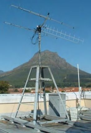
You can also read