ARCL0148 DIGITAL HERITAGE: APPLICATIONS IN HERITAGE MANAGEMENT
←
→
Page content transcription
If your browser does not render page correctly, please read the page content below
Institute of Archaeology

       ARCL0148 DIGITAL HERITAGE:
 APPLICATIONS IN HERITAGE MANAGEMENT
                                         2020-21, Term 2
                                           MA module
                                            15 credits

                                     Co-ordinator: Gai Jorayev
                                    Email: g.jorayev@ucl.ac.uk
                                            Room: 602

                             Office hours: 12.00-14.00 on Wednesdays

    Please refer to the online IoA Student Handbook (https://www.ucl.ac.uk/archaeology/current-
    students/ioa-student-handbook) for instructions on coursework submission, IoA referencing
    guidelines and marking criteria, as well as UCL policies on penalties for late submission.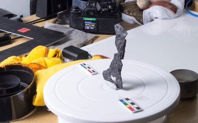
ARCL0148

   1. MODULE OVERVIEW
Module description
Digital Heritage: Applications in Heritage Management module introduces students to the latest
developments in the use of digital technologies for management of heritage across the world.
The sessions look at different tools, software packages, approaches and outcomes by
continuously linking them to realities and restrictions that are present in archaeological sites,
historic buildings, museums and wider heritage management institutions. The module is about
providing students with an opportunity to put heritage management theory into practice by using
digital tools. It will showcase the achievements and demonstrate the role of UCL Institute of
Archaeology in this developing area, reflecting its expertise and capabilities as part of its Digital
Heritage Laboratory. The course is designed to look at the latest developments and to remain
very contemporary.

It has become increasingly clear over the last several years that learning about the practical use
of digital technologies in the areas of site and object documentation, condition assessment and
developing interpretation strategies is the main attraction for the students. Therefore, the
module is not specifically designed to teach ‘digital’ - although the students will gain new digital
competencies as part of the course - but the programme has been developed with the view of
demonstrating the benefits of digital tools for the modern day, holistic management of heritage.
Increased emphasis on digital documentation, presentation and display will enable an expanded
focus for the module that goes beyond the use of digital technologies to document and monitor
the heritage, and the course will also explore how the datasets are curated and communicated.

One of the module’s main aims is giving students an opportunity to carry out practical tasks in a
real-life heritage management environment. The course coordinators typically use London-
based heritage sites for practical exercises. That is problematic in the current environment of
the extensive lockdowns and it may not be possible to implement this as part of the Term 2 of
2020-21 academic year. Therefore, the course will take a traditional form of lectures and
seminars for this particular term, with practical activities shifted to Term 3 (summer 2021).
Those activities will not be assessed, but every effort will be made to provide new practical skills
to the students nevertheless. The advanced methods that are taught as part of the practical
exercises are valued highly by researchers as well as by our partners who are the owners or
managers of the heritage sites.

Intended learning outcomes
Students will learn how to deploy advanced methods for documentation and condition
assessment, and how to use fully digital solutions for the benefit of heritage management. The
course teaches 3-dimensional recording techniques with focus on cheap and rapid tools for
comprehensive modelling, analysis and monitoring of heritage sites. Subsequent integration of
the data into geographical information systems and virtual environments (VR) is taught with
strong considerations of wider heritage management needs.

It gives students an opportunity to learn professional heritage management skills, written and
practical, in a supportive and team-based environment. Students are expected to work in small
teams on project work, which culminates in a presentation at the end.

On successful completion of the module students should be able to demonstrate:

                                                  1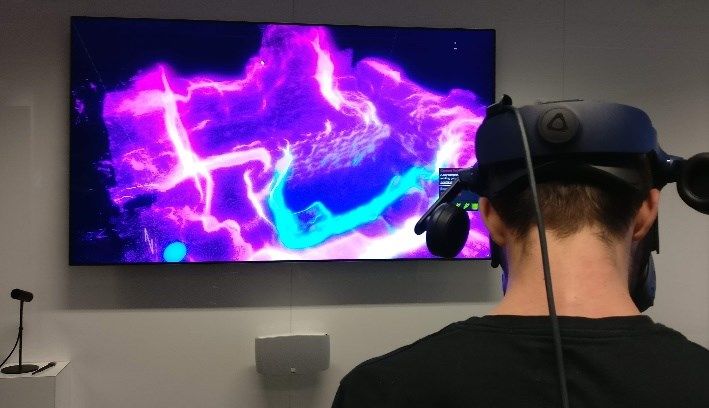
ARCL0148

       •          Observation and critical reflection
       •          Application of acquired knowledge
       •          Written and oral presentation skills

Module Aims
       •          To provide an understanding of the processes and approaches used in digital
                  form in order to implement value-based management, conservation and
                  interpretation of a heritage site or object
       •          To encourage innovative digital approaches
       •          To develop team-working skills applicable to the working world

Objectives
On successful completion of this module a student should:

   •       Understand the tools and techniques for documenting condition, monitoring the
           change and interpretation
   •       Critically assess ways in which heritage management theory and practice interact
   •       Understand how their learning can be applied in the working world
   •       Be able to discuss their practical work with future employers

Communications
  •    Moodle is the main hub for this course.

  •    Important information will be posted by staff in the Moodle and registered students will
       automatically receive an email notification for those.

  •    Microsoft Teams will be primary channel for communication and online teaching. The
       registered students will receive an invitation to join the Teams Group for this module.

  •    Please post any general queries relating to module content, assessments and
       administration in the MS Teams module forum (or alternatively via email if you
       prefer).

  •    For personal queries, please contact the co-ordinator by email.

Weekly Module Plan
The module is taught through lectures, case studies and discussions. Each week will have a
message via Moodle with recommended additional materials (mostly videos, interactives, and
short case studies). Students will be required to undertake set readings and complete pre-class
activities before the 2-hour sessions on Monday in order to be able to actively participate in the
discussion.
The teaching sessions are on Mondays, 12.00 – 14.00.

                                                     2
ARCL0148
Each week’s learning will be supported by essential reading, recommended and optional
reading. There will be continuously updated online reading list
(https://rl.talis.com/3/ucl/lists/CC468721-903E-36C0-3044-A6F26A45B3FA.html) containing
materials available online on open-access and via UCL Library access.
Additional readings and learning materials in the form of news articles, reports and datasets will
be made available on Moodle under each weekly session. They will be used to facilitate seminar
discussions.
Some weeks will feature a Case Study that is centred around weekly themes. These will often
include conversations/interactions with external specialists.
Additional practical skills, especially in the area of software use, will be provided by the course
coordinator and the students will be supported individually where necessary.
Workload
This is a 15-credit module which equates to 150 hours of learning time
including session preparation, background reading, and researching and writing your
assignments. With that in mind you are expected to organise your time roughly in this manner:
20 hours Staff-led teaching sessions (lectures, seminars, tutorials, discussion-board sessions)
60 hours Self-guided session preparation (reading, listening, note-taking and online activities),
about 6 hours a week
70 hours Reading and preparing for, and writing, the assignments
3ARCL0148
2. ASSESSMENT
Ongoing restrictions imposed due to the pandemic resulted in a change of assessment for this
course for 2020-21 academic year. Instead of planned Group project report (75 of overall mark)
and Critical Reflection (25% of overall mark), there will be a one 4,000-word assignment this
year.
The assignment will be a combination of a classical essay and project work. The course
coordinator will work with each student closely to agree a specific research project/exercise and
to provide full support. Further details will be announced in the first session.
Assignment 1: approximately 4,000 words.
Deadline: 12th April 2021.
Despite the restrictions, the plans are in place to use the assignment as a way of providing the
students with new skills and providing an opportunity to research new areas of developments in
digital heritage. Possible approaches to it will be discussed in class, and individually with every
student, in advance of the submission deadline. If students need further guidance or are unclear
about the nature of an assignment, they should discuss this with the Module Co-ordinator in
advance (via office hours, class Teams channel or email). The students will receive feedback on
their written coursework via Moodle, and will have the opportunity to discuss their marks and
feedback with the co-ordinator.
The marking criteria and IoA writing guidelines (https://www.ucl.ac.uk/archaeology/current-
students) are useful guides when writing your essay. There are penalties for late submission.
Penalties for exceeding the word limit: For work that exceeds a specified word limit by less
than 10% the mark will be reduced by five percentage marks, but the penalised mark will not be
reduced below the pass mark: marks already at or below the pass mark will not be reduced.
For work that exceeds a specified word limit by 10% or more the mark will be reduced by ten
percentage marks, but the penalised mark will not be reduced below the pass mark: marks
already at or below the pass mark will not be reduced.
The following should not be included in the word count of coursework and dissertations:
coversheet, title page, contents pages, lists of figure and tables, abstract, preface,
acknowledgements, bibliography, captions and contents of tables and figures, appendices.
3. READING AND RESOURCES
Preparation for class
You are expected to read the two essential readings as well as familiarising yourself with
suggested materials on Moodle each week. Completing the readings is essential for your
effective participation in the activities and discussions. Further readings are also provided as
part of the online reading list for you to get a sense of the range of current work on a given
topic and for you to draw upon for your assessments. It is essential that you check the online
reading list regularly.
Online reading list: https://rl.talis.com/3/ucl/lists/CC468721-903E-36C0-3044-A6F26A45B3FA.html
4ARCL0148
4. WEEK-BY-WEEK SUMMARY / SYLLABUS
In broad terms, the weeks of the term are divided into major areas of interest and investigation.
Through those specific areas, we will also look at wide variety of contemporary issues of digital
aspects of heritage management, and support those with extensive range of case studies and
discussions of the best practice.
The main title of each week is presented here. Please, see detailed syllabus below for more
information.
Term 2
Week Date Topic / Theme
1 11 Jan Introduction to digital documentation in heritage. What this course is about?
2 18 Jan Photogrammetric recording as a rapid-documentation tool.
3 25 Jan Satellite imagery and airborne remote sensing: historical overview and current
trends.
4 1 Feb Unmanned Aerial Vehicles: a true game changer for archaeological documentation?
5 8 Feb VR and AR: something usable or just a PR?
6 READING WEEK
7 22 Feb Landscape-level data visualisation and GIS.
1 Mar Digitisation of conventional records, archives and historical collections, and ethical
8
considerations.
9 8 Mar Curating the data: Long-term sustainability and Open data.
15 Mar Digital recording of objects, Crowdsourcing and benefitting from recent advances of
10
information technologies.
22 Mar Conclusions (Including discussions over digital footprint and our ‘heritage’ in born-
11
digital version).
The sessions will be run by Gai Jorayev. Some of the weekly discussions/themes will involve
contributions from guest speakers.
Week 1: Introduction to digital documentation in heritage. What this course
is about?
The session will start with discussions of the Digital Heritage in its wider meanings and then
explain what this course is trying to achieve and why it was created as a specific module. What
are the major advantages of using digital tools and techniques in archaeology and heritage
management? How the evolution from conventional, mostly paper-based methods to full-digital
took place and can we envisage certain future trends by looking back at that evolution? How
much the ongoing restrictions of access and travel is influencing the acceleration of the move
into ‘digital’ within the heritage institutions? How important are the digital competences for a
modern-day heritage specialist and where are the major sources of knowledge in this area?
5ARCL0148
The session will also discuss the digital documentation in differing scales: from objects to sites
and to large landscapes. Subsequently, it will broadly address the different tools and techniques
that are going to be discussed in detail as part of the module.
As a group discussion, we will also test our knowledge of digital data and its formats. Do we
know the difference between raster and vector, lossy and lossless, proprietary and non-
proprietary, etc? What are the basic concepts that one needs to be aware of in order to support
their digital skills and knowledge?
Week 2: Photogrammetric recording as a rapid-documentation tool.
Among many approaches currently used by the heritage specialists for high-resolution recording
of different assets, one particular approach stands out for its ease of implementation and for its
advantages in terms of rapid documentation. The session will provide general overview of the
photogrammetric recording (or Structure from Motion (SfM) photogrammetry, as it is otherwise
known) and discuss advantages and disadvantages of the approach. Could this revolutionise
aspects of documentation process? How does it compare to more prominent documentation
techniques such as 3D laser scanning? Can photogrammetric recording deliver full survey
datasets that traditionally relied on combination of several tools and techniques such as
differential GPS units and tacheometer?
If used widely and supported properly photogrammetric recording offers relatively easy learning
curve as well as scalability from small objects to large landscapes, and therefore is seen as one
of the easiest skills that can be gained as part of the short trainings. The course coordinator has
an extensive experience in experimenting with this particular approach and training the
specialists in different parts of the world, and some of the case study discussions will be based
on those experiences. We will also focus on the ‘rapid’ part of the topic and discuss it as an
approach for documenting heritage under threat.
Week 3: Satellite imagery and airborne remote sensing: historical overview
and current trends.
The Space Race in the second part of the 20th century, and later proliferation of the Earth’s
lower orbit with multitude of different satellites, sensors and satellite systems created a range of
tools that continuously found new implementations for different scientific research endeavours.
Uniform satellite imagery coverage of the Earth’s surface started to become available to wider
public in early 21st century, initially via the web interfaces and later through dedicated software
packages such as Google Earth. Subsequent developments ensured that the coverage in
different chronological periods is also available for public. This types of datasets are also
supplemented by traditional aerial photography, taken from different aerial vehicles, which has
even longer history and closeness to archaeological research. The session will discuss the
benefits as well as the challenges of using remote sensing data in heritage management.
Both satellite and airborne data collection go well beyond simple Grayscale or RGB
photography and different sensors are used to measure, capture and analyse waves that are
beyond the spectrum of the visible light. Multi-spectral sensors as well as LiDAR became one of
the most beneficial tools for heritage specialists globally and the session will provide an
overview of developments in this area.
6ARCL0148
Additionally, the remote sensing currently benefits from various forms of historic imagery. There
are several exciting developments in digitisation or publication of historical imagery that is giving
even wider chronological span to the data in specific areas and enabling longer-term change-
over-time analysis.
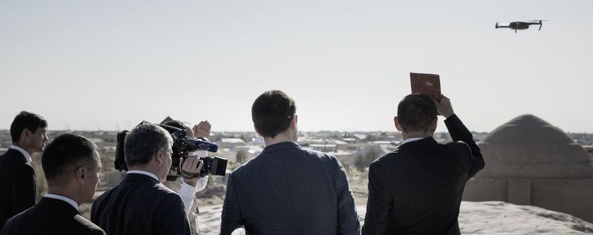
Week 4: Unmanned Aerial Vehicles: a true game changer for
archaeological documentation?
Recent technological advances resulted in rapid proliferation of ‘drones’ or Unmanned Aerial
Vehicles (UAV) into our lives. They are becoming omnipresent and loved and feared almost in
equal measure, if to judge the reaction by their media coverage. For archaeology and heritage
management, they create more flexible level of remote sensing that can operate even closer to
the sites and monuments than the conventional aerial data collection discussed in previous
session. Alongside its many advantages and opportunities, the use of UAV comes with range of
disadvantages from safe operation to data management. The session will look at those in detail
and discuss vast array of research activities undertaken recently with the use of UAV systems.
This is one of the areas of huge in-house expertise and the session will provide a good
opportunity to discuss pros and cons of the approach with detailed case studies. Can UAV’s
with their flexibility and rapid deployment capacity be the ultimate solution for our need of spatial
data? What type of sensors can we use with UAV’s? What are the latest trends in heritage-
specific UAV developments?
Week 5: VR and AR: something usable or just a PR?
Virtual Reality (VR), Augment Reality (AR) or Mixed Reality are often seen as pinnacles of data
visualisation and they are especially relevant to heritage because of their ability of making
interpretation process more interactive. From museums (controlled environment) to different
archaeological sites (less controlled and fluid environment), there are many heritage
organisations that use different approaches in this area. As first part of the session, we will look
data collection and preparation: Is any 3-dimentional data VR/AR ready? How to ensure the
compatibility? Following that, we will look at usability: Can we use VR/AR easily in heritage
setting? What are the major challenges for heritage institutions?
The session will also critique and reflect on outcomes: How usable these approaches and do
they result in improved interpretation? How beneficial are they for wider engagement with
communities or for supporting local education initiatives? Finally, we will also look at the issue
of sustainability: Do these approaches require extensive resources and how to ensure that they
are usable and accessible for wider range of heritage institutions?
Week 6: Reading Week – no classes.
Week 7: Landscape-level data visualisation and GIS.
Collecting digital data is a good start but making that data understandable to and usable by
multiple stakeholders requires some sort of visualisation and curation of those dataset. In terms
of the landscape or site level datasets, a variety of software packages commonly known under
the term Geographical Information Systems (GIS) is used to achieve that goal of visualisation
and manipulation. Although learning one of the mainstream GIS packages is becoming
increasingly important for heritage specialists in order to benefit from full range of functionalities,
7ARCL0148
simpler tools also exists that allow visualisation and simple analytical work even without the
mastery of complex jargon and knowledge of statistical/database tools. GIS packages differ
substantially in their ease of use and capabilities and the session will provide an overview of
currently available solutions and modern approaches.
More broadly, the session will also look at the issues of resolution, accuracy, and
representation. Do we always need the highest resolution of data or should we look at ratio of
resources needed for certain outputs? Should we always create our spatial datasets, or can we
benefit from freely available materials? How does different coordinate systems and projections
interact with each other in GIS environment and what are the implications for heritage
specialists?
We will also take a more in-depth look into the GIS jargon: What is the digital cartography and
where are the internet map-servers? What are the most used algorithms for purposes of
heritage documentation? How does one see the ‘patterns’ in spatial data? Etc.
Week 8: Digitisation of conventional records, archives and historical
collections, and ethical considerations.
Archaeology and heritage management are disciplines that are based on long tradition of
creating records. Archaeological archives and monument records are extensive sources to rely
on for research and management heritage in any part of the world. But most of them exists in
conventional or ‘analogue’ forms – based on paper, film or glass negatives, tape, or similar –
and represent varying degrees of fragility. Issues of access, lack of searchability and metadata
hamper their usability. Therefore, turning them into digital formats is a priority for many
organisations and several large-scale projects exist at our Institution to that end too.
However, digitisation is not a simple process of scanning and storing the data, but a complex
set of steps and measures that turns information on physical carriers into a digital information
that is usable by many stakeholders and different software packages for many different goals.
We will discuss approaches and key concepts in this area.
The session will also address a broader question: What happens to the collections after
digitisation and how the issues of ethics are addressed in this area? Does the digitisation and
documentation mean the end of a lifecycle of the records? These questions will set the
beginnings of discussions of ethics in digital heritage in general.
Week 9: Curating the data: Long-term sustainability and Open data.
Creating the digital data in its different forms from different sources, and even making it usable
via different platforms does not necessarily guarantee long-term preservation of data. The loss
and corruption of digital data is a major issue, and curating the data is critical in order to benefit
from it for managing heritage in the longer term. What are the approaches to making digital data
sustainable? Is it about making data carriers sustainable and formats interoperable, or is it
something more complex? How institutional policies should address the risk management in this
area? These are increasingly pertinent questions in the age of ‘big-data’ and heritage related
datasets have some unique sensitivities that increases the need for considerate and planned
approaches.
8ARCL0148
From simple data that is ‘thrown’ into the internet to materials under Creative Commons
licenses, we will also have an overview of modern approaches to open data. This will provide us
with an opportunity to return to the issue of data formats and long-term operability of the data.
Week 10: Digital recording of objects, Crowdsourcing and benefitting from
recent advances of information technologies.
Recording objects in archaeological and museum context represent certain unique challenges
and the session will start by looking at those based on examples. Using detailed recording and
collection of additional data for informing conservation decisions is becoming a norm for many
institutions and this is an exciting new area where developments are combining several aspects
of the digital documentation and presentation to a great effect.
The second part of the session will look at strategies of using existing information technologies
and networks for supporting digital data collection, curation and dissemination. Among other
aspects, we will be looking at crowdsourcing.
Additionally, the session will look at broader issues of ethics in the use of digital data and its
implications for reconstruction based on a digital record, copyright, authenticity, etc.
Week 11: Conclusions & review (Including discussions over digital footprint
and our ‘heritage’ in born-digital version).
This will be an overall summary of the course and a detailed discussion of its main messages.
We will return to the themes of lectures and seminars and readdress the areas that may need
additional discussions. We will use the session to present additional materials and updates, and
discuss the future learning sources.
This is also a session to address some of the major issues over authorship and ethics in the
digital world. Additionally, we will look at ‘Digital heritage’ from another angle: What happens to
a digital footprint that we create? What about the works and outputs that only exist in digital
format? Is it a ‘heritage’ and if so, how to cater for it?
9You can also read