Deliverable D2.3 Customized platform for the Netherlands Demo Case (First Version) - Ground Truth 2.0
←
→
Page content transcription
If your browser does not render page correctly, please read the page content below
Ref. Ares(2018)593603 - 31/01/2018

Deliverable D2.3
Customized platform
for the Netherlands Demo Case (First
Version)

The Ground Truth 2.0 project has received funding from the European Union's Horizon 2020
Research and Innovation Program under grant agreement No. 689744. www.gt20.eu
Deliverable Title                   Customized platform for Netherlands Demo Case (First Version)
Status                              Final
Related Work Package                WP2 Enabling technologies
Deliverable lead                    HR
Author (s)                          Rianne Giesen
Internal reviewer (s)               Cristina Montachini, Alberto Masa, Nicolas Luque (Altran)
Contact for queries                 Rianne Giesen (HR), rianne.giesen@hydrologic.com
Dissemination level                 Public
Due submission date                 31.08.2018 (M12)
Current submission                  31.01.2018 (M17)
Project acronym                     Ground Truth 2.0
Grant agreement number              689744
Funding scheme                      H2020-SC5-2015-two-stage / Topic SC5-17-2015 / Innovation Actions
Abstract of Deliverable             Ground Truth 2.0 (GT2.0) aims to demonstrate that sustainable Citizen
                                    Observatories (COs) are possible. This is done using the innovative
                                    approach of combining the social dimensions of citizen observatories with
                                    enabling technologies, so that the implementation of the respective
                                    citizen observatories in six Demo Cases is tailored to their envisaged
                                    societal and economic benefits.
                                    This report presents the first version of the platform for the Dutch DC
                                    Citizen Observatory that was developed jointly with end users during co-
                                    design sessions.

Versions and Contribution History

Version      Date               Modified by                            Modification details

V0.1         22.01.18           Rianne Giesen                          Initial draft

V0.2         24.01.18           Cristina Montachini, Alberto Masa, Review and comments
                                Nicolas Luque

V0.3         25.01.18           Rianne Giesen                          Fully revised draft

                    The Ground Truth 2.0 project has received funding from the European Union's Horizon 2020
                    Research and Innovation Program under grant agreement No. 689744. www.gt20.eu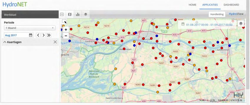
Table of Contents
Versions and Contribution History ............................................................................................................... 1
List of figures ................................................................................................................................................ 2
List of tables ................................................................................................................................................. 2
List of abbreviations ..................................................................................................................................... 2
Executive Summary ...................................................................................................................................... 4
1. Introduction.......................................................................................................................................... 5
   1.1      Background................................................................................................................................... 5
   1.2      Purpose of the document............................................................................................................. 5
   1.3      Structure of the document ........................................................................................................... 5
2. Summary of Functional Design for the platform of the Dutch Demo Case ......................................... 6
   2.1      Mission, Vision and Objectives of the Citizen Observatory ......................................................... 6
   2.2      Functional Design ......................................................................................................................... 7
   2.2.1       Tools for the development of the platform ............................................................................. 8
   2.2.2       Data Collection and data aggregation .................................................................................... 11
   2.2.3       Monitoring and assurance of the technical performance of the platform ............................ 12
   2.2.4       Standardization of data management.................................................................................... 12
   2.2.5       Enhanced services .................................................................................................................. 13
3. Platform technical design and integration of components of the Citizen Observatory .................... 14
   3.1      Platform architecture and selection of technological tools to use ............................................ 14
   3.2      Mock-up and feedback ............................................................................................................... 15
4. Presentation and description of contents of the Citizen Observatory platform (First version) ........ 17

List of figures
Figure 1: Vision, mission and objectives ...................................................................................................... 7
Figure 2: Functional design with main headlines for DC-NL Grip op water Altena...................................... 8
Figure 3: Homepage of the Grip op water Altena platform. ........................................................................ 9
Figure 4: Example maps on the HydroNET platform. ................................................................................. 10
Figure 5: ESRI Story Maps on the Grip op water Altena platform. ............................................................ 11
Figure 6: Gavagai Monitor dashboard for DC-NL themes. ......................................................................... 12
Figure 7: Technical architecture of the platform (initial/medium term version)...................................... 14
Figure 8: Header of the platform website .................................................................................................. 17
Figure 9: Top part of the homepage .......................................................................................................... 17
Figure 10: Lower part of the homepage..................................................................................................... 18
Figure 11: Page Water op de kaart with ESRI Story Maps. ........................................................................ 19
Figure 12: Page Wateroverlast ................................................................................................................... 20
Figure 13: Page Maatregelen ..................................................................................................................... 21
Figure 14: Page About us, Grip op water Altena ........................................................................................ 22
Figure 15: Twitter page of Grip op water Altena ....................................................................................... 23

List of tables
Table 1: Pages and content on the web platform. ..................................................................................... 15
Table 2: Necessary tasks to develop the first version of the CO from the mock-up.................................. 16
Table 3: Development of the technical platform Grip op water Altena. Technical design and integration of
components................................................................................................................................................ 24
Table 4: .Summary of contents of each page of Grip op water Altena website (first version). ................. 31

                                                                                                                                                                2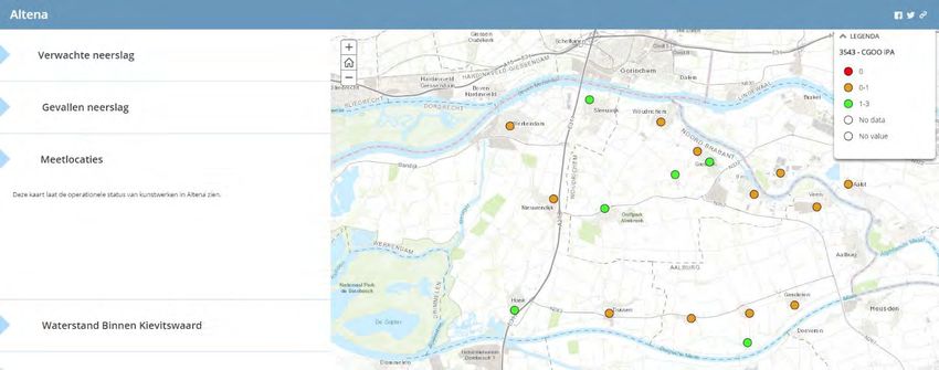
List of abbreviations
CO         Citizen Observatory
DC         Demo Case
DC-NL      Demo Case Netherlands (Dutch demo case)
GT2.0      Ground Truth 2.0
URTT       User Requirement Tracking Tool
WP         Work Package

            The Ground Truth 2.0 project has received funding from the European Union's Horizon 2020
            Research and Innovation Program under grant agreement No. 689744. www.gt20.eu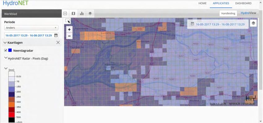
Executive Summary
Ground Truth 2.0 (GT2.0) aims to demonstrate that sustainable Citizen Observatories (CO) are possible.
This is done using an innovative approach combining the social dimensions of citizen observers with
enabling technologies so that the implementation of the respective citizen observatories is adapted to
the social and economic benefits anticipated.
The topic of the Dutch demonstration case (DC-NL) is climate proof water management. Because of the
changing climate, the frequency and severity of heavy precipitation events and droughts increases. Policy
makers take measures to prevent and reduce the damage caused by such events, but citizens can also
contribute to make their neighbourhood climate proof. For instance by reducing the percentage of paved
surface in their gardens or by contributing to weather and water related observations.
The geographic focus of DC-NL is the region Land van Heusden en Altena (short name Altena), which
experienced two extreme rainfall events in the summers of 2014 and 2015. The common goal of the
stakeholders is to prevent damage from extreme precipitation, this is reflected in the chosen name for
the platform: Grip op water Altena.
This document describes how, starting from the functional design and going through the technical design
and integration of IT components, the first version of the Dutch demo case platform was developed. The
platform will provide information on weather, water and measures. Users can share information and tips,
contribute observations on the water system and communicate with different stakeholder groups. Its
online presence is at altena.gripopwater.nu.

                                                                                                        4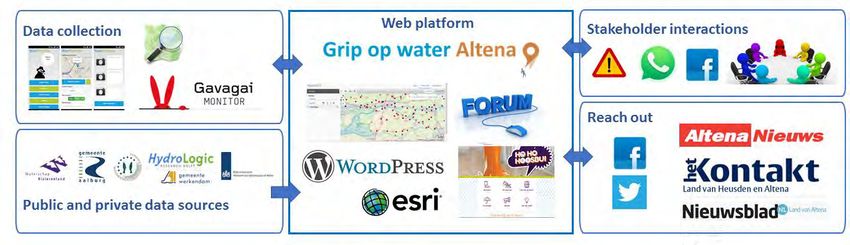
1. Introduction

    1.1 Background
The Ground Truth 2.0 project will deliver the demonstration and validation of six scaled-up citizen
observatories in real, operational conditions, with four European and two African demonstration cases. It
will demonstrate the technological feasibility, the sustained use and the societal and economic benefits
of such citizen observatories. The ultimate objective is the global market uptake of the concept and
enabling technologies.
One of the main objectives of WP21 is to enable adequate customization, deployment and upscaling of
the required technical solutions in each demonstration case. Considering the different starting points and
the differences in the cases’ requirements, the aim is to set up a technological architecture in each case,
taking into account both common modules as well as particular ones.
Within this frame, the Task T2.1, Technical design and integration of components per demonstration case,
will settle the specific requirements of each demonstration case, based on the user’s requirements made
during the work carried out as Task T1.3, Functional design. The Task T2.1 is being developed with the
purposes of: make the technical design of the Demo Case; develop standard integration between
demonstration cases; and configure the technological platform in each demonstration case.

    1.2 Purpose of the document
This document is one of the Task T2.1 outputs. It describes how, starting from the functional design of the
Demo Case, going through the technical design and integration of IT components, the first version of the
CO platform was developed.

    1.3 Structure of the document
The present document is divided into 4 sections in order to give a comprehensive overview of the
customized platforms of each Demo Case.
Section 1 presents an introduction to the document, giving details about the background, the purpose
and the structure the document.
Section 2 is a summary of the Functional Design for the platform. It describes the results of the planning
carried out by the co-design group that participate in the DC. The co-design group, through co-design
work sessions, defined and validated the Vision, Mission and Objectives of the Citizen Observatory, the
customized Functional Design and the Technical Design.
Section 3 presents the platform architecture validated by the co-design groups of the DC, designed to
satisfy the user requirements of the customized Functional Design, the selection of technological tools
and the mock-up developed to obtain feedback from the co-design group.
Finally, Section 4 presents and describes the first version of the platform, created based on the customized
Functional Design and the feedback from the co-design group.

1
  Ground Truth 2.0 - Environmental knowledge discovery of human sensed data, D0.A extract FINAL for kick-off,
1.3.3. WT3 Work package descriptions

                  The Ground Truth 2.0 project has received funding from the European Union's Horizon 2020
                  Research and Innovation Program under grant agreement No. 689744. www.gt20.eu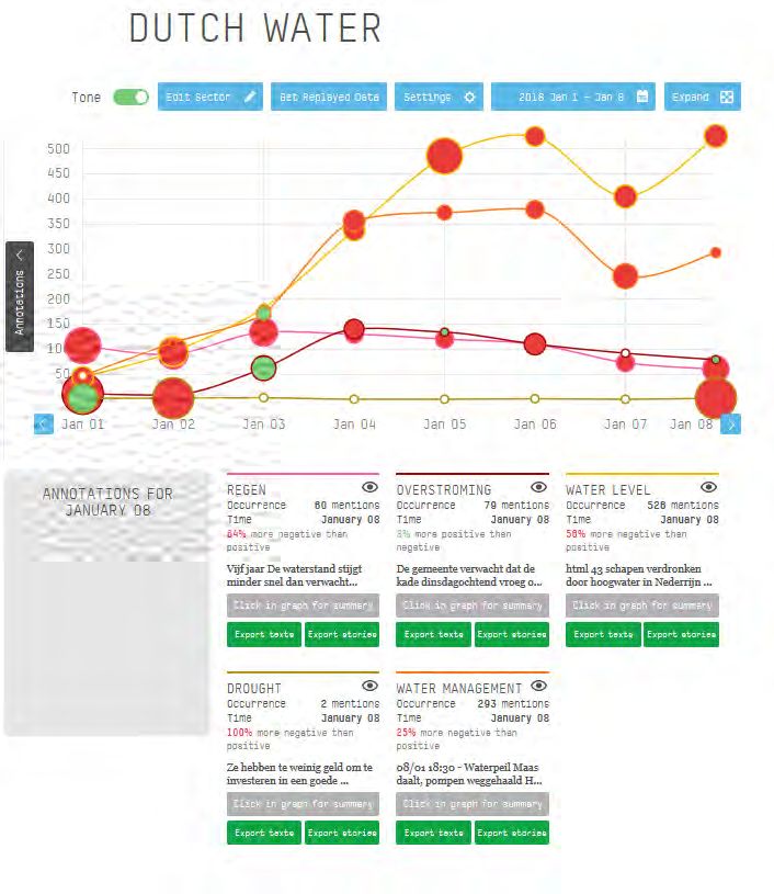
2. Summary of Functional Design for the platform of the Dutch Demo
   Case
In the first co-design session, the challenge of the DC-NL was formulated. The co-design group stated that
‘If we do not take measures, our urban and rural areas will keep being affected by local flooding because
of the extreme weather resulting from climate change.’ This challenge forms the basis for the Vision,
Mission and Objectives for the Demo Case Citizen Observatory. Then, the functional design for
accomplishing that premises was developed.

   2.1 Mission, Vision and Objectives of the Citizen Observatory
The members of the co-design group defined validated the Vision, Mission and Objectives of the Citizen
Observatory, as given below.
Vision: In Land van Heusden en Altena the municipalities, water authority, citizens and farmers
understand each other's interests and ways of working and are together responsible for limiting the
damage by pluvial flooding in urban and rural areas.
Mission: The citizen observatory is a place (on- and offline) where collected observations, knowledge and
warnings are shared, where bottlenecks and measures are constructively discussed along short
communication lines and where it is clear which actions are taken by which party.
Objectives:
    1. Facilitate the exchange of observations and information about the weather and water systems [in
       October 2017] to allow all stakeholders to act or plan ahead.
    2. Support short communication lines and insight in plans and activities of stakeholders regarding
       water management in Land van Heusden en Altena [early 2018]
    3. Set up a knowledge platform with action perspectives and tips to take measures against damage
       from pluvial flooding [in the course of 2018]
    4. Support an open and constructive dialogue between all involved parties in Land van Heusden en
       Altena [from the start] and expand the network towards a real water community.
    5. Prepare the sustainable continuation of this CO after GT2.0 [in 2018 en 2019]
The vision, mission and objectives are summarised in Figure 1 below.

                                                                                                         6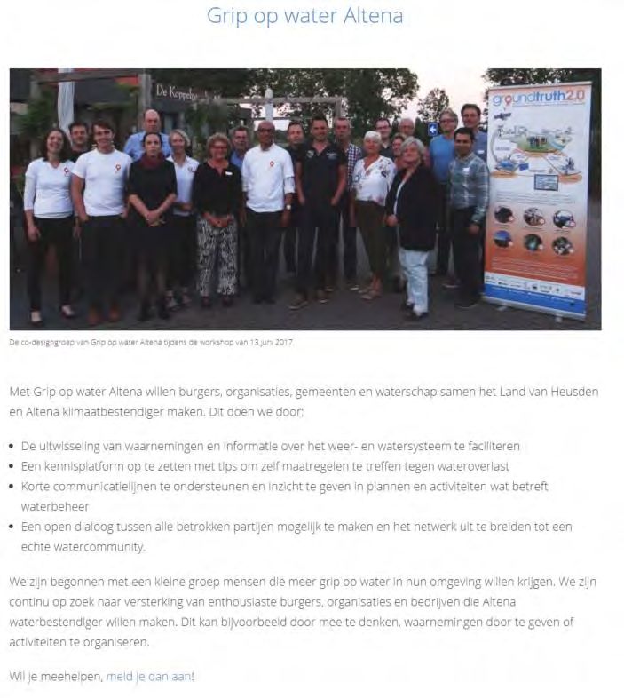
In Land van Heusden en Altena the municipalities, water
                     authority, citizens and farmers understand each other's interests
                     and ways of working and are together responsible for limiting the
                           damage by pluvial flooding in urban and rural areas.

    The citizen observatory is a place (on- and offline) where collected observations, knowledge and
    warnings are shared, where bottlenecks and measures are constructively discussed along short
            communication lines and where it is clear which actions are taken by which party.

     1. Facilitate            2. Support             3. Set up a         4. Support an            5. Prepare
    the exchange             short com-             knowledge              open and                   the
      of observa-            munication               platform           constructive            sustainable
       tions and               lines and            with action             dialogue            continuation
     information               insight in          perspectives           between all             of this CO
       about the              plans and             and tips to              involved            after GT2.0
    weather and              activities of               take               parties in           [in 2018 en
      water sys-            stakehol-ders            measures               Land van                 2019]
     tems [in Oc-             regar-ding               against            Heusden en
     tober 2017]                 water             damage from           Altena [from
      to allow all          manage-ment                pluvial              the start]
    stakeholders             in Land van            flooding [in          and expand
    to act or plan           Heusden en            the course of         the network
         ahead.             Altena [ear-ly              2018]              towards a
                                 2018]                                     real water
                                                                          community.

Figure 1: Vision, mission and objectives

    2.2 Functional Design
In GT2.0, functional design is defined as a method to translate the stakeholders’ requirements into design
features (see D1.5 Functional design of the citizen observatories). A generic “Story Map”2 was proposed
to guide the development of a customized story map for each DC. It was also proposed that the user
requirements are stored in a “User Requirement Tracking Tool” (URTT)3 to allow for easy tracking of their
status and to identify the corresponding layer in the platform architecture.
Departing from the generic Story Map as a reference point, the co-design group developed their own
Story Map from the perspective of the future users of the Citizen Observatory, citizens, scientists and
policy makers (Figure 2). The customized and validated entries in the URTT form the basis for the
deployment of the platform architecture of Grip op water Altena.
Grip op water Altena offers its community members two main opportunities: A platform to share and
access various sources of information, and channels serving to improve the communication between

2
 The generic Story Map is fully described in Ground Truth 2.0 “Deliverable D1.5, Functional design of the citizen
observatories”.

                     The Ground Truth 2.0 project has received funding from the European Union's Horizon 2020
                     Research and Innovation Program under grant agreement No. 689744. www.gt20.eu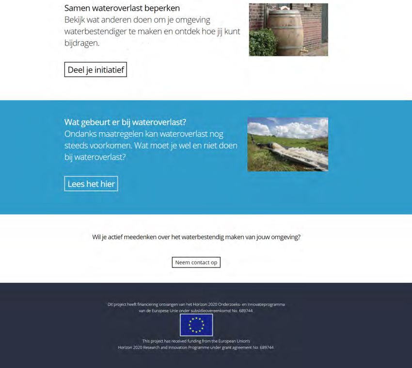
citizens, farmers, municipalities and water authority. Collected data can support both storylines, but is
not an essential part of the observatory from the beginning.
Figure 2: Functional design with main headlines for DC-NL Grip op water Altena
2.2.1 Tools for the development of the platform
WordPress
The layout and content of the platform website have been created in WordPress, a free and open-source
content management system. WordPress has primarily been chosen because it is widely used and has a
large number of plugins available for various functionalities.
For the current platform (Figure 3), the following plugins have been added:
- WP Google Maps and Basic Google Maps Placemarks, to easily add placemarks to a Google Map
- Contact Form 7, to configure contact forms
- Responsive menu, to allow for scalability of the platform for viewing on laptops, tablets and
mobile phones
- Share buttons by GetSocial.io, to add social sharing buttons and track social sharing
WordPress is currently installed on a server owned by HydroLogic Research (demonstration case leader),
but in such a generic way that it can easily be transferred to a different server if required.
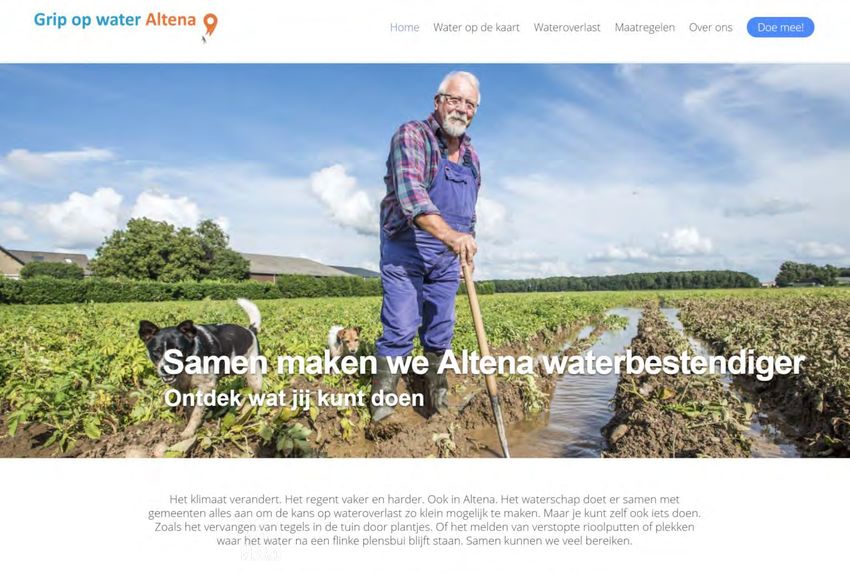
8Figure 3: Homepage of the Grip op water Altena platform.
HydroNET platform
Weather and water data and information are made available through the HydroNET platform.
The HydroNET system has been developed by HydroLogic Research and is based on the Software as a
Service (SaaS) paradigm. HydroNET runs from a cloud infrastructure and is used both in research and
commercial environments.
In HydroNET, open protocols are used to couple existing platforms and create a chain of information
services, connecting a variety of distributed data sources through a system of backend services. Online
models assimilate, calibrate, forecast and aggregate data into information which is shared via a network
of application services and made available to a wealth of web-based applications with real-time thematic
maps (Figure 4).
The Ground Truth 2.0 project has received funding from the European Union's Horizon 2020
Research and Innovation Program under grant agreement No. 689744. www.gt20.euFigure 4: Example maps on the HydroNET platform.
ESRI Story Maps
ESRI Story Maps is used to create a gallery of maps from different sources (HydroNET, Rijkswaterstaat)
and combine them with explanatory text in a consistent way (Figure 5).
10Figure 5: ESRI Story Maps on the Grip op water Altena platform.
2.2.2 Data Collection and data aggregation
As the collection of weather and water data does not have the highest priority for the DC-NL, tools for
data collection will be integrated in a later version of the platform.
Gavagai Monitor
Online conversations on topics directly related to the theme of Grip of water Altena are being monitored
with the Gavagai Monitor. This tool searches for pre-defined keywords on news sites, in blogs and Twitter
feeds and performs statistics on the results. The Gavagai Monitor analyses the sentiments in the
messages, indicating whether conversations are dominantly negative or positive.
For the DC-NL, the Gavagai Monitor searches for keywords associated with five predefined themes: rain,
flooding, water level, drought, water management. In addition, a filter was added with names of towns
and cities in the area of interest to allow for geographical selection of messages (Figure 6).
The Ground Truth 2.0 project has received funding from the European Union's Horizon 2020
Research and Innovation Program under grant agreement No. 689744. www.gt20.euFigure 6: Gavagai Monitor dashboard for DC-NL themes.
2.2.3 Monitoring and assurance of the technical performance of the platform
Usage of the platform website is being monitored with Google Analytics. The technical performance of
the platform is monitored by HydroLogic’s IT-team within their standard testing procedures.
2.2.4 Standardization of data management
As no data is being collected in the first platform version, this is not yet implemented.
122.2.5 Enhanced services
Apart from the tools presented above, no enhanced services have been implemented in the platform.
This is foreseen for later versions.
The Ground Truth 2.0 project has received funding from the European Union's Horizon 2020
Research and Innovation Program under grant agreement No. 689744. www.gt20.eu3. Platform technical design and integration of components of the Citizen
Observatory
3.1 Platform architecture and selection of technological tools to use
The validated functional design was translated into a technical design, where existing data and
information sources, as well as communication channels are integrated into one platform (Figure 7). The
central place is the web platform at altena.gripopwater.nu created with WordPress.
On the web platform, the user finds interactive maps with weather and water information from external
data sources. These maps are configured using open and private data provided through HydroNET
(precipitation product, measurements water authority Rivierenland) and publicly available maps (e.g.
Rijkswaterstaat). All maps are brought together and supplemented with explanatory text in the ESRI Story
Maps interface.
There is static basic information on what measures can be taken, based on existing websites like
hohohoosbui.nl (water authority Rivierenland), Rainproof Amsterdam and huisjeboompjebeter.nl). The
static information is augmented with dynamic information and tips from community members (forum).
Google Maps plugins are used to include maps showing implemented measures and reports on the water
system.
Online and offline stakeholder interactions will inform and be informed by the communication on the web
platform. Online tools used are WhatsApp (co-design group communication) and a Facebook page. A
wider audience is reached through online social media (Twitter, Facebook) and printed/online local media
channels (local newspaper).
Data collection will be implemented in a later stage of the platform.
Figure 7: Technical architecture of the platform (initial/medium term version)
14The pages on the web platform are designed around sets of user stories (Table 1).
Table 1: Pages and content on the web platform
Page Content
Home Teasers and links to the other pages
Water on the map Weather and water information maps
Flooding Information on what to do in case of flooding
Information on tasks of different organisations
Personal stories (to be added)
Measures Map with measures taken by different
stakeholders
Information on what measures stakeholders (can)
take
About us Grip op water Altena
Ground Truth 2.0
Join us Contact form
The information on the web platform will be continuously expanded. Next steps are integration of
comment functionality and a news section.
3.2 Mock-up and feedback
During the mock-up session in September 2017, the co-design group were given paper versions of
example HydroNET maps, information on hohohoosbui.nl and the proposed layout for the web platform.
A returning comment from the co-design group is that provided information and data needs to be actual
and tailored to their situation and region. Maps should be zoomed in to cover the Altena region. Measures
taken should not be general, but show what the water authority and municipalties are actually working
on in their region.
A multitude of devices was used during the mock-up session, directly illustrating the need to set up a
responsive platform that works on different screen sizes.
During the mock-up session, a name was chosen for the observatory. Grip op water covers the focus on
water-related issues, not restricted to pluvial flooding. This allows for expansion of topics, for example
with river flooding and water quality issues. The local nature of the observatory is reflected in the addition
Altena, which is the name of the new municipality to be formed by January 2019 by merging the three
existing municipalities. The regional name has been kept separate in the domain name
(altena.gripopwater) to allow for easy expansion to other regions, still keeping the local focus of each
observatory. As the most obvious domain name, gripopwater.nl, was already registered to another party,
we chose the domain name gripopwater.nu.
The Ground Truth 2.0 project has received funding from the European Union's Horizon 2020
Research and Innovation Program under grant agreement No. 689744. www.gt20.euTable 2: Necessary tasks to develop the first version of the CO from the mock-up
Task Tools Responsible
Register domain name gripopwater.nu Web hosting HR
Register Twitter account Twitter HR
Design logo Grip op water Altena Inkskape HR
Create website content (text and figures) WordPress HR
Create precipitation maps HydroNET HR
Create aggregated map page ESRI Story Maps HR
164 Presentation and description of contents of the Citizen Observatory
platform (First version)
The first version of the platform Grip op water Altena (altena.gripopwater.nu) has been made available
online on 16 January for testing by the co-design group. This was a soft launch, there was no suitable
event to connect to for a big public launch.
The website is available in Dutch, use of the Dutch language throughout was a strong requirement of the
co-design group and stresses the local character.
The header on the website shows the observatory logo on the left side (Figure 8). The logo includes the
colours and the pin from the Ground Truth 2.0 logo. On the right side, the different menu items are
available, as presented in Table 1.
Figure 8: Header of the platform website
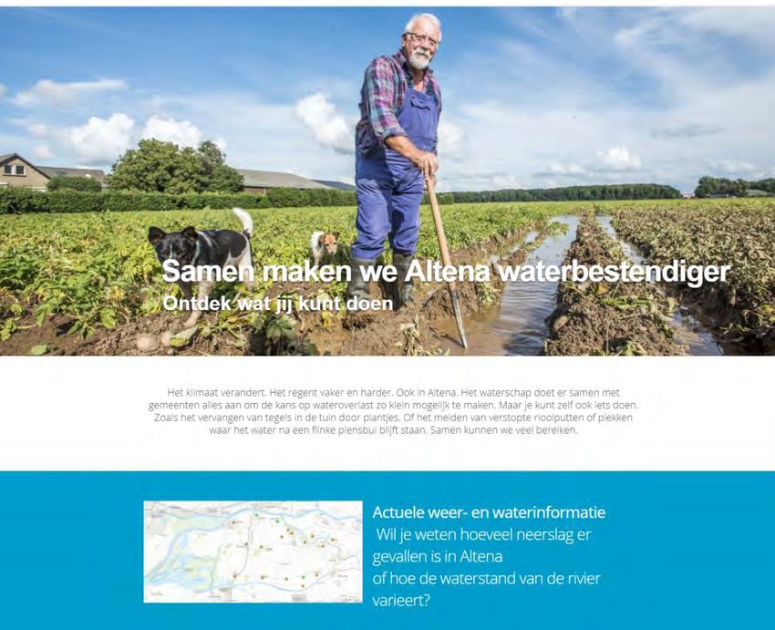
The homepage starts with a large picture, followed by a call to action (Figure 9). Below are coloured blocks
with teasers to the different pages on the website.
Figure 9: Top part of the homepage
The Ground Truth 2.0 project has received funding from the European Union's Horizon 2020
Research and Innovation Program under grant agreement No. 689744. www.gt20.euThe lower part of the homepage (Figure 10Figure 10) includes additional links to the pages on the website
and the acknowledgement of the EU funding in two languages (Dutch and English). This bar is included in
all the pages.
Figure 10: Lower part of the homepage
18Water op de kaart currently includes five maps (three from HydroNET, two from Rijkswaterstaat) with
weather and water information (Figure 11). The layout is configured with ESRI Story Maps. More maps
will be added when the water authority makes their data available.
Figure 11: Page Water op de kaart with ESRI Story Maps.
The page Wateroverlast provides the contact information of the authorities in case of flooding (Figure
12). More content will be provided by the municipalities and the water authority, citizens will add personal
stories.
The Ground Truth 2.0 project has received funding from the European Union's Horizon 2020
Research and Innovation Program under grant agreement No. 689744. www.gt20.euFigure 12: Page Wateroverlast
The page Measures shows a map where measures taken by the community members can be added,
together providing an overview of what is being done in Altena (Figure 13
Figure 13). The map is based on Google Maps with a plugin for placeholders. Below the map is a link to a
form where visitors can share their measures. The page furthermore contains short descriptions of
measures and links to pages with more detailed information.
20Figure 13: Page Maatregelen
The Ground Truth 2.0 project has received funding from the European Union's Horizon 2020
Research and Innovation Program under grant agreement No. 689744. www.gt20.euThe page About us contains more information about Grip op water Altena and Ground Truth 2.0 (Figure
14).
Figure 14: Page About us, Grip op water Altena
The page Doe mee contains a contact form that collects the visitor’s name and e-mail address and sends
it to HR currently. Information will be provided promptly after receiving the request.
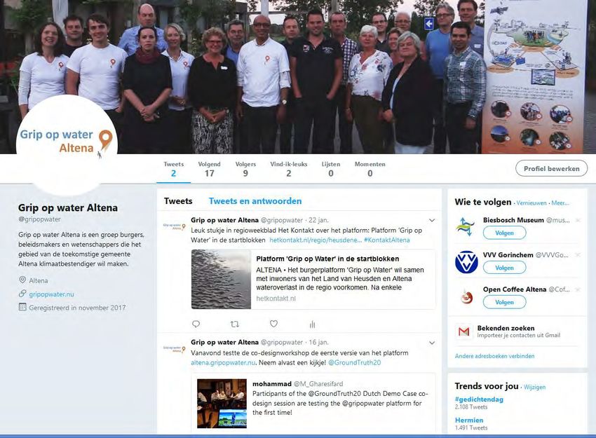
22The Twitter page of Grip op water Altena (https://twitter.com/gripopwater) is used to share news from
the observatory and other related sources and to get in contact with a wider audience (Figure 15).
Figure 15: Twitter page of Grip op water Altena
The Ground Truth 2.0 project has received funding from the European Union's Horizon 2020
Research and Innovation Program under grant agreement No. 689744. www.gt20.euThe matching of the tools, headlines and platform content is presented in Table 3 and
Table 4.
Table 3: Development of the technical platform Grip op water Altena. Technical design and integration of components
FIRST VERSION PLATFORM IMPLEMENTATION
YES/N WHY
HEADLINES SUBHEADLINES TOOL WHERE?
O NOT?
Read portal/info WordPre http://altena.gri
yes
pages ss popwater.nu
Not yet
Watch videos no applica
ble
DISCOVER Not yet
Play games/do
THE no applica
quizzes
OBSERVAT ble
ORY WordPre
ss, http://altena.gripopwater.nu/wat
HydroNE er-op-de-kaart
Access public
yes T and
data/materials http://altena.gripopwater.nu/maa
ESRI
Story tregelen
Maps
Not yet
Take guided tours no applica
ble
Register Final WordPre
account/agree no platfor ss
terms m (plugin)
Provide
JOIN THE information Not yet
COMMUNI required for user no applica
TY assessment/verifi ble
cation
Create profile & Not yet
link to other no applica
users ble
24Choose Twitter, https://twitter.com/gripopwater,
notifications yes Faceboo https://www.facebook.com/gripo
channels k, e-mail pwateraltena/
FIRST VERSION PLATFORM IMPLEMENTATION
HEADLINE SUBHEADLIN YES/N WHY
TOOL WHERE?
S ES O NOT?
WordPres
Submit open s, Google
observations Maps, http://altena.gripopwater.nu/maatr
for yes Google egelen
exploration Maps
and discovery Placemark
er
Send
notifications Final
No
to “go and platform
observe”
Submit
observations
SUBMIT according to Final
No
AND research platform
PROCESS protocols and
DATA instructions
Not yet
Add tags and
no applicabl
meta-data
e
Provide
Final WordPres
comments on no
platform s
observations
WordPres
s,
Integrate
HydroNET http://altena.gripopwater.nu/water
external data yes NA
and ESRI -op-de-kaart
sets
Story
Maps
The Ground Truth 2.0 project has received funding from the European Union's Horizon 2020
Research and Innovation Program under grant agreement No. 689744. www.gt20.euFIRST VERSION PLATFORM IMPLEMENTATION
WHY
HEADLINES SUBHEADLINES YES/NO TOOL WHERE?
NOT?
SUBMIT AND
Validate/process Not yet
PROCESS No
scientifically applicable
DATA
Rate and review Possibly
no
activities offline
EVALUATE
RESEARCH Launch or respond to Not yet
ACTIVITES OR no
surveys applicable
POLICY/
STEWARDSHP
RESULTS Post or review results final
no
data platform
Possibly
Discuss results no
offline
Not yet
View instruction videos no
applicable
Access/download
Not yet
manuals and field No
applicable
guides
TRAIN AND
LEARN
Not yet
Test knowledge no
applicable
Create and get
Not yet
feedback on test no
applicable
submissions
26FIRST VERSION PLATFORM IMPLEMENTATION
YES
SUBHEADLI / WHY
HEADLINES TOOL WHERE?
NES NOT?
NO
Develop
Not yet
TRAIN AND personal
no applicab
LEARN competencie
le
s
WordPre
ss,
Search/Brow
HydroNE
se http://altena.gripopwater.nu/water-op-
yes T and
observatory de-kaart
ESRI
data
Story
Maps
WordPre
ss,
Browse HydroNE
http://altena.gripopwater.nu/water-op-
observatory yes T and
de-kaart
database ESRI
Story
USE Maps
KNOWLEDG
WordPre
E HUB TO
ss,
UPLOAD OR View maps
HydroNE
ACCESS and http://altena.gripopwater.nu/water-op-
yes T and
EXISTING visualization de-kaart
ESRI
DATA, s
Story
INFORMATI
Maps
ON AND
SERVICES WordPre
ss,
Upload
HydroNE
existing data http://altena.gripopwater.nu/water-op-
yes T and
and de-kaart
ESRI
information
Story
Maps
WordPre
ss,
Use CO HydroNE
http://altena.gripopwater.nu/water-op-
knowledge yes T and
de-kaart
hub ESRI
Story
Maps
The Ground Truth 2.0 project has received funding from the European Union's Horizon 2020
Research and Innovation Program under grant agreement No. 689744. www.gt20.euUse Not yet
enhanced No applicab
services le
INFLUENCE
Participating
BROADER WordPre
decision yes http://altena.gripopwater.nu
POLICY ss
makers
AGENDAS
REACH OUT Share
http://altena.gripopwater.nu
AND RAISE contents on WordPre
social media https://twitter.com/gripopwater
AWARENES ss
S Yes (plugin) https://www.facebook.com/gripopwate
raltena/
FIRST VERSION PLATFORM IMPLEMENTATION
YES/ WHY
HEADLINES SUBHEADLINES TOOL WHERE?
NO NOT?
No yet
no applica
Create, send or ble
read newsletters
Final
Download platfor
REACH information/pro No
m
OUT AND motion materials
RAISE
AWARENES Not yet
Launch or take applica
S No
part in online ble
campaigns
WordPr http://altena.gripopwater.nu
ess,
https://twitter.com/gripopwater
Twitter,
Find/join/promot Yes Faceboo https://www.facebook.com/gripop
e offline activities k wateraltena
Post Final
DISCUSS concerns/ideas in No platfor
AND SET discussion fora m
THE CO
28AGENDA Take part in (live) Final
FOR online No platfor
RESEARCH discussions m
AND
NATURAL WordPr
Organize offline ess, http://altena.gripopwater.nu
RESOURCE yes
MANAGEM activities WhatsA WhatsApp group
ENT pp
Interpret
Not yet
exploratory data
No applica
and set internal
ble
agenda
Develop a shared WordPr http://altena.gripopwater.nu
yes
vision ess
FIRST VERSION PLATFORM IMPLEMENTATION
WH
YES
Y
HEADLINES SUBHEADLINES / TOOL WHERE?
NOT
NO
?
WordPre http://altena.gripopwater.nu
Communicate ss,
https://twitter.com/gripopwater
new yes Twitter,
policies/plans Faceboo https://www.facebook.com/gripopwa
k teraltena
SUPPORT Access info
IMPLEMENTAT how to WordPre http://altena.gripopwater.nu/doe-
yes
ION OF PLANS comply/partici ss meemee/
AND POLICES pate
WITH WordPre
Create, http://altena.gripopwater.nu
MONITORING ss,
AND promote or https://twitter.com/gripopwater
Twitter,
INFORMATION find offline Yes https://www.facebook.com/gripopwa
Faceboo
SHARING activities teraltena
k
WordPre http://altena.gripopwater.nu
ss,
Track progress https://twitter.com/gripopwater
Twitter,
of activities Yes https://www.facebook.com/gripopwa
Faceboo
k teraltena
The Ground Truth 2.0 project has received funding from the European Union's Horizon 2020
Research and Innovation Program under grant agreement No. 689744. www.gt20.euWordPre
ss,
HydroNE
Monitor status http://altena.gripopwater.nu/water-
yes T and
of a resource op-de-kaart
ESRI
Story
Maps
Encourage
compliance
and facilitate WordPre http://altena.gripopwater.nu
yes
communication ss
with formal
authorities
Post policy
WordPre http://altena.gripopwater.nu
drafts and
yes ss and
request
PARTICIPATE offline
feedbacks
IN POLICY
CONSULTATIO Provide WordPre http://altena.gripopwater.nu
NS AND feedback on yes ss and
DESIGN policy drafts offline
PLANNING WordPre http://altena.gripopwater.nu
ACTIVITIES Organize/Invite ss,
https://twitter.com/gripopwater
to off-line Twitter,
activities Yes Faceboo https://www.facebook.com/gripopwa
k teraltena
FIRST VERSION PLATFORM IMPLEMENTATION
WHY
HEADLINES SUBHEADLINES YES/NO TOOL WHERE?
NOT?
PARTICIPATE IN Report on results of Not yet
no
POLICY the planning process applicable
CONSULTATIONS
AND DESIGN
PLANNING
ACTIVITIES Platform features to Not yet
no
co-design mutually applicable
30Table 4: .Summary of contents of each page of Grip op water Altena website (first version)
Netherlands Story
Map
Page Content Headline
- User card
Grip op water Links to all website pages and platform functionalities. H1. Discover the
Altena [Home observatory
page] - 1.1. Read portal and info
pages
Water op de Maps with external, partly publicly available data H4. Use CO to upload or
kaart [Water on access existing data,
the map] information and service
- 4.3. View maps and
visualizations
Wateroverlast Information on past flooding events, who takes care of H1. Discover the
[Water what and what to do in case of a (threatening) flooding observatory
nuisance] event - 1.4. Access public
data/materials
Maatregelen Stakeholders can upload the measures they have taken, H3. Submit and process
[Measures] these are visualized on a map. In addition, there is data
information on the measures that can be taken by - 3.1. Submit open
different stakeholders. observations for
exploration and discovery
Over ons Introduction of the Dutch demo case, links to the H1. Discover the
[About us] contributing organisations, introduction of the Ground observatory
Truth 2.0 project. - 1.4. Access public
data/materials
Doe mee Visitors can fill in a contact form to request more H2. Join the CO community
[Join us] information. For the final platform, an online - 2.1. Register account and
registration procedure will be added. agree terms
The Ground Truth 2.0 project has received funding from the European Union's Horizon 2020
Research and Innovation Program under grant agreement No. 689744. www.gt20.euYou can also read