Research on integrated application prospect of railway civil engineering survey and design system based on computer technology
←
→
Page content transcription
If your browser does not render page correctly, please read the page content below

Journal of Physics: Conference Series

PAPER • OPEN ACCESS

Research on integrated application prospect of railway civil engineering
survey and design system based on computer technology
To cite this article: Chenyu Wu 2021 J. Phys.: Conf. Ser. 1982 012198

View the article online for updates and enhancements.

                               This content was downloaded from IP address 46.4.80.155 on 01/10/2021 at 00:39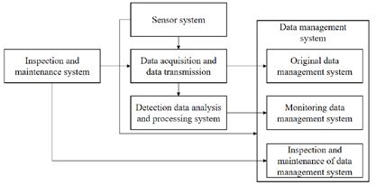
ICAIIS 2021                                                                                                     IOP Publishing
Journal of Physics: Conference Series                         1982 (2021) 012198          doi:10.1088/1742-6596/1982/1/012198

Research on integrated application prospect of railway civil
engineering survey and design system based on computer
technology

                     Chenyu Wu*
                     Central South University School of Civil Engineering Changsha, Hunan 410083 China

                     *Corresponding author: wcy200009012021@163.com

                     Abstract. With the continuous improvement and improvement of computer aided
                     design software, engineering designers gradually break away from the paper work of
                     drawing board and draw drawings by computer. These soft wares have strong usability
                     and flexibility. By calling the entity primitive model in the library, the three-
                     dimensional model of the scheme line is constructed in real time, and it is checked and
                     modified in the three-dimensional environment, and different structure types are
                     compared to realize the three-dimensional entity route selection design. It is the trend
                     of the times to integrate and intelligentize from survey design to construction, and it is
                     also the necessary means and demand to enhance the market competitiveness of road
                     and civil engineering survey general contracting projects. The BIM modeling method
                     of existing line structure using advanced survey means needs to be further improved.
                     The main structures of the railway line are modeled based on Civil3D. After assembly
                     and debugging, BIM modeling of various types of railway line structures can be
                     realized.

                     Keywords: Railway; Civil engineering survey; System integration

1. Introduction
The integration and intelligence of survey and design is a technological revolution in the field of survey
and design. In the design of railway route selection, line engineers must make full use of their domain
knowledge and information to analyze the natural environment such as topography, geology and
hydrology, so as to design a railway line that meets the requirements of politics, economy and
technology. In addition, with the construction of high-speed railway and the wide application of
ballastless track technology, the settlement requirements of bridges, culverts, tracks and other
engineering structures of high-speed railway become more stringent, and the measurement accuracy is
extremely high, so the settlement of high-speed railway has been paid close attention [1].
    At present, the traditional methods of manual measurement combined with indoor analysis and
evaluation are mostly used to evaluate the operation status of large-scale important infrastructures such
as railway bridges in China. In order to improve the design quality and speed, since 1950s, experts and
scholars in railway and road fields have begun to explore the theory and method of computer-aided
              Content from this work may be used under the terms of the Creative Commons Attribution 3.0 licence. Any further distribution
              of this work must maintain attribution to the author(s) and the title of the work, journal citation and DOI.
Published under licence by IOP Publishing Ltd                          1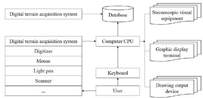
ICAIIS 2021                                                                                IOP Publishing
Journal of Physics: Conference Series          1982 (2021) 012198    doi:10.1088/1742-6596/1982/1/012198

route design based on digital terrain information [2-3]. Practice shows that BIM technology has
superior technological innovation and rationality. Compared with the traditional track plane design [4],
BIM design can simplify the track plane design, increase the automation level of computer aided
design, and thus greatly shorten the design cycle.

2. Modeling of line structure based on BIM

2.1 Modeling of rail and fork rail structure
In Civil3D, besides the three-dimensional model that can be built by the designer as required, there are
also basic design elements that make up the circuit, called "components", which can be called directly
[5]. The forms of track lines vary widely, which can be attributed to different components, such as
lanes, guardrails, ditches, etc., and then assembled in a unified way. These components have design
parameters, and each component can automatically change its configuration according to different
engineering parameters. It is convenient to call directly for modeling. However, the railway track
structure is complex, and the components that can be called directly in Civil3D are only simple single-
track ballastless track, and the modeling is not accurate and precise enough.
    The core of turnout design based on BIM technology is to establish a systematic three-dimensional
digital turnout model, so that turnout components are interrelated and different types of turnout BIM
models can be assembled [6]. This system focuses on solving the problems of field survey and
digitalization of geological exploration. According to the requirements of railway survey and design
specifications, the original database with geological data as the core is established. The virtual
environment hardware system of the design system is a computer integrated system which can carry out
3D virtual reality simulation, and has the ability of high performance calculation and 3D interactive
design. Its basic configuration is composed of general computer, special graphics equipment, digital
terrain information acquisition equipment and stereo visual equipment, as shown in Figure 1.

 Fig.1 Hardware environment configuration diagram of railway digital route selection design system
    For railway line designers, in order to establish a three-dimensional physical model of railway
turnout, it is necessary to obtain complete and accurate surface shape information of turnout. In addition
to the action information to be added in the later stage, the turnout BIM model needs to include basic
main structure information and attribute information. For example, the turnout BIM can extract
corresponding view elements, including plan view, 3D view and section view, and call its geometric
dimension information, attribute information and quantity information in the whole life cycle, and
manage the turnout model by sub-unit to facilitate assembly and modification.

2.2 Track structure modeling
At present, the line major has basically completed the integration of horizontal, vertical and horizontal
design software development. Bridge major: At present, bridge major has a lot of calculation software.
Tunnel major: at present, the development of new single-line design program has been installed in the
tunnel major. Ground and road specialty: some commonly used subgrade design and some supporting
design software have been introduced and developed. The system provides users with various functions
and operations in the form of menu commands and menus. The system consists of menu items such as
project management, environmental modeling, scheme management, line modeling, view, image, 3D
landscape roaming, engineering technical indicators, engineering geological information management,

                                                     2
ICAIIS 2021 IOP Publishing
Journal of Physics: Conference Series 1982 (2021) 012198 doi:10.1088/1742-6596/1982/1/012198
window management, stereo adjustment and help, etc. The monitoring results post-processing
subsystem, early warning subsystem, manual monitoring data management and analysis subsystem'
monitoring data analysis, management and evaluation subsystem'.
The sensor system can sense the changes of structural stress and temperature, environmental
temperature and humidity, wind speed and direction, structural deformation and displacement during
the operation of bridge structure. The obtained original signals such as voltage, current and frequency
are collected by the data acquisition and transmission system and transmitted to the monitoring data
analysis and processing system for processing [7]. Due to the rapid development of computer
technology, the corresponding information technology, network technology and communication
technology also need to be continuously developed, and its content and meaning also need to be
continuously expanded, while the theory and thinking methods also need to be updated, enriched and
developed. The development of engineering survey and design database is not intelligent enough, and
there is still a long way to go before it is practical to refer to database management system, graphic data
management system and file centralized output management system.
Other components, such as sleepers, fasteners, road bed boards, etc., are not provided with drawing
parameter input interface because of their complex structure and basically fixed size. The method of
establishing 3D library is adopted to write programs, and the drawing process is packaged in a
computer and automatically completed. In order to facilitate designers to call the component model,
windows can be set, and it is the compilation process of macro command interface windows in Civil3D.
3. Design principle of system node sensor structure
Considering the reusability and reliability of the sensor, the structure and main performance parameters
of the sensor are designed to minimize the conversion structure of optical fiber perception of
environmental variables; An ideal application model of system integration should be able to connect all
the related objects and operate comprehensively according to the needs to achieve the overall goal. Let
the strain sensing element be in a single tension state as much as possible, and the change of
environmental variables is linearly related to the change of optical signals; The actual sensitivity of the
sensor is controlled to meet the engineering monitoring requirements; For large engineering structures,
passive temperature compensation is adopted.
The main function of the sensor subsystem is to convert the structural response information into
electrical (optical) signals through various types of sensor components, which can be processed and
analog-to-digital converted by the data collection, transmission and storage subsystem.
The water level variation in the container at any measuring point or reference point in the static
leveling system, that is, the absolute settlement of the measuring point, can be calculated according to
the following formula [8]:
∆h = (R1 − R0 )× G
In which:
R1 ——Sensor current reading (mm);
R0 ——Sensor initial reading (mm);
G ——Sensor coefficient (mm/digit), usually a positive value, given by the manufacturer;
∆h ——The water level variation of the container (mm), when ∆ > 0 , the water level drops, and
vice versa.
The calculation method of relative settlement of any measuring point in the static leveling system is
as follows:
X Relative settlement of measuring point = change of water level of measuring point container
(absolute settlement)-change of water level of reference point container (absolute settlement), and the
calculation formula is:
∆ELX = (R1 X − R0 X )× G X − (R1REF − R0 REF )× GREF
3ICAIIS 2021 IOP Publishing
Journal of Physics: Conference Series 1982 (2021) 012198 doi:10.1088/1742-6596/1982/1/012198
In which:
∆ELX ——The liquid level change (relative settlement) (mm) of measuring point X container,
when ∆ELX < 0 indicates settlement, and ∆ELX > 0 indicates increase.
R1 X , R0 X ——Current reading and initial reading of X sensor at measuring point (mm);
G X ——Sensor coefficient of measuring point X (mm/digit), which is given by the calibration
table of the sensor;
R1REF , R0 REF ——Current reading and initial reading of reference point (or reference point) sensor
(mm).
AutodeskCivil3D can accurately and efficiently describe different types of complex terrain, geology
and geomorphology. Under the increasingly urgent environment of 3D modeling, Civil3D is widely
used in BIM operations, with powerful functions and high intelligence, and the modeling technology is
mature and comprehensive. On this basis, optimize the construction organization, make a good
construction plan and arrange the construction progress, so as to guide the construction and special
construction plan. The construction organization design pays attention to the combination of
construction and design, the connection between the front station and the back station and various
professional projects, and makes overall planning, deployment and organization for the smooth
implementation of the project [9]. After the scheme line is set up, 3D line collaborative design can be
carried out in 3D environment window, 2D plane window and profile window. If the intersection point
is selected in 3D environment window, the intersection point can be moved to a new position.
Due to the need of passive temperature compensation, all the optical fiber sensors are equipped with
temperature measurement function. The sensor used to detect dam seepage is actually a temperature
sensor without heating the thermistor. The higher the simulation accuracy of the model, the elevation of
any point on the surface can be found first, and then calculated and described by interpolation algorithm
according to the elevation of its three vertices. There are many types or sources of data to build a
surface, which can be used alone, or interacted and mixed together to distinguish different data sources
and adopt corresponding modeling methods. Labor, materials, machinery and equipment available
during construction, natural conditions and technical and economic data of the construction site. This
requires engineering economic analysis, which is the basis for determining investment plans and
making financial allocations.
4. The concrete implementation and key technology of integration
4.1 Data acquisition, transmission and storage subsystem
The main function of the data acquisition, transmission and storage subsystem is to condition the
signals of various sensors installed on the high-speed railway subgrade and bridge, and then convert
them to analog-to-digital conversion, and then transmit them to the computer server of the monitoring
center through industrial Ethernet. It can provide dynamic and organized related data for multiple users,
effectively realize data sharing and cross-access, and effectively connect the field information
collection module with the upper management module; It is necessary to cooperate with experts from
different specialties, but not to take the design for granted. Therefore, when determining the database, it
should be comprehensively analyzed and based on the warehousing principle that shared data takes
precedence over internal data of specialties. Relying on SQL Server database, the program can set the
frequency of data collection and measurement. After the setting is completed, the program will
automatically analyze the messages sent from the bottom to the center, and store them in the database
according to the standard.
4.2 Use Civil3D to create 3d digital terrain
Triangulation digital surface model is the key to simulate the elevation characteristics of 3D digital
4ICAIIS 2021 IOP Publishing
Journal of Physics: Conference Series 1982 (2021) 012198 doi:10.1088/1742-6596/1982/1/012198
terrain or original terrain. The operation method of creating a triangulation surface model in Civil3D is
relatively simple. First, click the tab of the functional area to create a new surface, and then define the
surface type. In addition to commonly used triangulation surfaces in Civil3D, there are grid surfaces,
grid volume surfaces, triangulation volume surfaces, etc. Finally, set the name, layer, rendering material
and other information of the surface.
Through the analysis of railway structure and functional requirements, the railway structure health
monitoring system is an automatic monitoring system with hardware system as the platform, various
professional application software as the center, and the organic combination of software and hardware
systems, adopting the overall system structure as shown in Figure 2 [10]. The health monitoring system
consists of five parts: sensor system, data acquisition and transmission system, monitoring data analysis
and processing system, data management system and inspection and maintenance system.
Fig.2 General architecture of structural health monitoring system
Selection of data source to create 3D digital terrain and surface requires providing reliable and
effective data source. At present, the available effective data source should be the elevation points
provided by surveying and mapping units. After importing the point file, the generated surface may
have a big difference between elevation and actual terrain. After entering the 3D observation mode,
verify whether it is wrong or not, delete it. Discrete points with incorrect elevation information can be
deleted by using the surface property editing function of Civil3D. Before compiling the construction
organization, it is necessary to collect the following information, such as the construction drawings of
the project, the construction progress and requirements required by the project, the construction quota,
the project budget and relevant technical and economic indicators, the labor, materials and machinery
and equipment available in the construction, and the natural conditions and technical and economic data
of the construction site. The system also provides the function of comparison and selection of route
selection schemes for different structures, such as comparison and selection of tunnel schemes and high
cutting schemes.
4.3 Client real-time tracking and remote query subsystem
The subsystem mainly realizes the visualization function of the monitoring system, which can be
divided into two parts according to the visualization form: one is the real-time tracking platform
SMAIS UI Station set up on the spot; The other part is SMAIS Web Data Finder, which is a remote
query access platform installed on the network client. Because the state of the monitored bridge is
changing all the time, the relevant information in the database should be refreshed constantly; Data can
be transferred between various functional modules to realize data sharing, and can be connected to the
Internet for users to query data remotely. It is necessary to consider the unification of data format and
reduce redundant data. It will bring a lot of troubles to the application program in condition judgment,
which is inconvenient to work, and the storage problem of graphic data. Only the direct visual
registration of the two models is realized. This method is relatively simple, but when the landscape is
displayed or dynamically roams, it is easy for the models to have holes or dislocations at a certain
angle.
Another important component of the client-side real-time tracking and remote query subsystem is
the client-side remote query access platform SMAIS Web Data Finder, which can realize various
network clients including tablet computers, notebook computers, desktop computers, mobile phones,
5ICAIIS 2021 IOP Publishing
Journal of Physics: Conference Series 1982 (2021) 012198 doi:10.1088/1742-6596/1982/1/012198
etc., and query and access the field measurement data in real time. Several different models are
considered in the modeling process. For example, in the process of terrain modeling and structure
modeling, the models are synthesized by independent triangulation, and numbered uniformly one by
one, but each model is only visually established by triangulation. However, the intelligent software
integration technology can automatically monitor the quality of bridge structure without instructions
from operators, and feed back the monitoring results to the managers of bridge structure, making it
more convenient to monitor bridges anytime and anywhere.
4.4 Integration of survey, design and construction
In order to strengthen the management and coordination of survey and design integration and intelligent
research, a scheme design team for survey, design and construction integration and intelligent research
is set up, which is specifically responsible for the integrated scheme design and implementation plan of
the unit. Then, BIM model of railway line structure is established based on Civil3D. After subgrade is
generated, it is dynamically added to 3D digital terrain model. After editing and rebuilding
triangulation, the whole curved surface network is formed, and independent control between models is
realized. Users can design a standard report template in the software according to their own needs,
which includes text, pictures, monitoring data tables and data curves. That is to say, a control table
should be built to store the names and unique signs of construction projects, and a control field should
be set in each table to store the unique signs of construction projects, thus realizing the design purpose
of storing multiple construction projects in the same entity.
The principle of the overall plan approved by the Leading Group for Integration Promotion shall be
followed, and the existing software of each unit shall be thoroughly cleaned up, and the integrated
software list shall be submitted to be included in the integrated software replacement plan and the
solutions for vacant software. Determine the corner points and intersection areas of terrain triangulation
surface and foundation model, take the foundation corner points as the limiting points that must
participate in network construction, re-edit the affected original terrain surface, and nest the subgrade
model on the terrain model to form a unified triangulation surface. At the same time, an automatic
acquisition unit, an industrial computer, a wireless transmitter and acquisition software are installed on
the line. The acquisition frequency is to automatically measure all measuring points every 10 minutes,
and the measurement results will be sent to the offline monitoring center in the form of messages
immediately after acquisition.
5. Conclusion
China's railway construction is in the stage of rapid development, and railway route selection design is
an overall work related to the overall situation in the whole railway construction. It is of great
significance to promote the development of railway route selection technology by means of modern
information technology, and the automation level of railway survey and design has been greatly
improved. At the level of decentralized operation, manual operation and repeated labor still transmit
data in a large number of forms. If this continues, it is difficult to improve the overall level of survey
and design. The research on integration and intelligence of railway survey and design conforms to the
development trend of railway survey and design technology, and is an inevitable requirement for
modern railway survey and design enterprises to enter the market and participate in competition.
Civil3D has the function of creating digital ground model accurately and quickly. The original 3D
digital curved surface model, railway route design, cross-section and longitudinal section design and
subgrade model are created by using Civil3D. The established line structure model is "dynamically
introduced" into the subgrade model, which realizes the independent management of primitive models
and improves the efficiency of seamless splicing among original terrain, line foundation and line
structure BIM models.
References
[1] Tan Junyang. Research on the Application of Project Management in Computer Information
6ICAIIS 2021 IOP Publishing
Journal of Physics: Conference Series 1982 (2021) 012198 doi:10.1088/1742-6596/1982/1/012198
System Integration. Information and Computer (Theoretical Edition), vol.32, no. 06, pp. 17-19, 2020.
[2] Sun Li, Xu Ziqiang, Jin Qiao, et al. Research on the integration method of structural health
monitoring system based on BIM platform. Journal of shenyang jianzhu university (Social Science
Edition), no. 19, pp. 415, 2017.
[3] Liu Zhigang. Application of Computer Technology in Civil Engineering. Western Leather, vol.
039, no. 008, pp. 17-17, 2017.
[4] Ma zhanning. Application of computer science and technology in intelligent building. Intelligent
building and smart city, vol. 000, no. 003, pp. 50-51, 2018.
[5] Jiang Qin. Analysis and application of computer network system integration technology. Digital
Users, vol. 025, no. 035, pp. 62, 2019.
[6] Yin Hui. Research on design system construction of applied civil engineering specialty based on
BIM technology. Think tank era, vol. 000, no. 015, pp. 249-250, 2020.
[7] Tan Junyang. Research on the Application of Project Management in Computer Information
System Integration. Information and Computer (Theoretical Edition), vol.32, no. 06, pp. 17-19, 2020.
[8] Zhang Yulong. Discussion on Integrated Interface Management of High-speed Railway "Four
Electricity" System. China plant engineering, no. 6, pp. 26-27, 2017.
[9] Ye Hua-Wen, Li Xin-shun, Wang Li-Wu, et al. Establishment and application of bridge
information model (BrIM) based on a railway bridge. Sino-foreign Highway, vol. 38, no. 06, pp. 317-
320, 2018.
[10] Jiang Qin. Analysis and application of computer network system integration technology. Digital
Users, vol. 025, no. 035, pp. 62, 2019.
7You can also read