AI4GEO : A DATA INTELLIGENCE PLATFORM FOR 3D GEOSPATIAL MAPPING
←
→
Page content transcription
If your browser does not render page correctly, please read the page content below
The International Archives of the Photogrammetry, Remote Sensing and Spatial Information Sciences, Volume XLIII-B2-2021
                                                 XXIV ISPRS Congress (2021 edition)

      AI4GEO : A DATA INTELLIGENCE PLATFORM FOR 3D GEOSPATIAL MAPPING

     Pierre-Marie Brunet1, Pierre Lassalle1, Simon Baillarin1, Bruno Vallet2, Arnaud Le Bris2, Gaëlle
         Romeyer2, Guy Le Besnerais3, Flora Weissgerber3, Gilles Foulon3, Vincent Gaudissart4,
       Christophe Triquet4, Michael Darques4, Gwenaël Souille4, Laurent Gabet5, Cedrik Ferrero6,
                                 Thanh-Long Huynh7, Emeric Lavergne8
                                    1
                                        Centre National d'Etudes Spatiales, Toulouse, France
                                                          2
                                                            IGN, Paris, France
                                                       3
                                                         ONERA, Paris, France
                                                     4
                                                       CS-SI, Toulouse, France
                                          5
                                            AIRBUS DS Intelligence, Toulouse, France
                                                  6
                                                    GEOSAT, Bordeaux, France
                                                    7
                                                      QuantCube, Paris, France
                                                      8
                                                         CLS, Toulouse, France
                                                             http://ai4geo.eu

                         ABSTRACT                                                       2. AI4GEO INITIATIVE
                                                                          AI4GEO is a French scientific and industrial program
    The availability of 3D Geospatial information is a key
                                                                      aimed at lifting the technological barriers to the automatic
issue for many expanding sectors such as autonomous
                                                                      production of 2D and 3D Geographic Data. By applying
vehicles, business intelligence and urban planning. Its
                                                                      innovative artificial intelligence and big data technologies to
production is now possible thanks to the abundance of
                                                                      the processing of varied and precise geospatial data sources,
available data (Earth observation satellite constellations, in-
                                                                      it aims to automatically produce a 3D smart map. The
situ data, …) but manual interventions are still needed to
                                                                      AI4GEO consortium is composed of institutional partners
guarantee a high level of quality, which prevents mass
                                                                      (CNES, IGN, ONERA) and industrial groups (CS Group,
production. New artificial intelligence and big data
                                                                      AIRBUS Defense and Space, CLS, GEOSAT, QWANT,
technologies adapted to 3D imagery can help to remove these
                                                                      QUANTCUBE) covering the whole value chain of
obstacles. The AI4GEO project aims at developing an
                                                                      Geospatial Information. Started at the end of 2019, the project
automatic solution for producing 3D geospatial information
                                                                      is funded for 4 years by the French future investment program
and new added-value services. This paper will first introduce
                                                                      led by the Secretariat General for Investment and operated by
AI4GEO initiative, context and overall objectives. It will then
                                                                      public investment bank Bpifrance. The project is structured
present the current status of the project and in particular it will
                                                                      around 2 axes which will progress simultaneously:
focus on the innovative platform put in place to handle big
3D datasets for analytics needs and it will present the first             The first axis consists in developing a set of building
results of 3D semantic segmentations and associated                   blocks allowing the automated production of qualified 3D
perspectives.                                                         maps and their additional layers of information (3D objects
                                                                      and related semantics), as illustrated in Fig. 1. This
Index Terms— Data processing, Photogrammetry, 3D,
                                                                      collaborative work will benefit from the latest research from
Semantic segmentation, Big Data, Platform.
                                                                      all the partners (imagery, AI and Big Data technologies) as
                                                                      well as from an unprecedented database (satellite and
                     1. INTRODUCTION
                                                                      airborne data (optics, radars, lidars) combined with
    The availability of huge volumes of satellite, airborne and       cartographic and in-situ data).
in-situ data now makes the production of 3D Geospatial
information feasible at large scale.
   It needs nonetheless a certain level of manual intervention
to secure the level of quality, which prevents mass
production.

                                                                                     Fig. 1. 3D maps and semantics

                                                 This contribution has been peer-reviewed.
                  https://doi.org/10.5194/isprs-archives-XLIII-B2-2021-817-2021 | © Author(s) 2021. CC BY 4.0 License.          817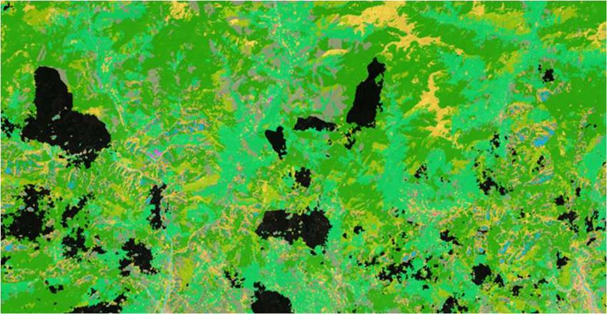
The International Archives of the Photogrammetry, Remote Sensing and Spatial Information Sciences, Volume XLIII-B2-2021
                                                 XXIV ISPRS Congress (2021 edition)

   The second axis consists in deriving from these                        •    A complete Integrated Development Environment
technological bricks a variety of new services illustrated in                  (IDE) based on Visual Studio Code. This is
Fig. 2 for fields targeted by industrial partners.                             complementary to the notebook approach, mostly
                                                                               prototyping oriented.
                                                                          •    EODAG [4], a Python framework with a JupyterLab
                                                                               plugin that acts as a catalog proxy. Thus, it
                                                                               simplifies data discover by providing a standard API
                                                                               through a single access point.

                    Fig. 2. Industrial services
     The project could also contribute to other fields and
services (e. g. Precision Agriculture, or Robotics) thanks to
the IT platform that will be accessible via CS Group.                                    Fig. 3. VRE interface

     This list could be extended in the future by early adopters         In addition to these plugins, the VRE includes a large
(e. g. Precision Agriculture, or Robotics). It is also important     number of EO libraries (e.g. OTB, PANGEO) and AI
to highlight that the project will benefit from the arrival of       ecosystem (Tensorflow, Keras or Pytorch as well as tools
satellite constellations such as AIRBUS Pleiades-Neo                 such as tensorboard) facing the challenge to provide a
program (in 2021) and above all CNES CO3D program [1]                complete set of tools whose versions are compatible with
that will greatly increase the provision of accurate 3D Very         each other.
High Resolution data.                                                    Two kind of visualizer are provided. The first one is fully
                                                                     integrated into the VRE environment and let users to
     3. AI4GEO DATA ANALYTICS PLATFORM                               immediately have a look on their results. 2D visualizer is
                                                                     based on a light and performant tile manager that can handle
   Considering the dramatic increase of data and processing
                                                                     large volume of images fluently. Besides a 3D visualizer,
needs for new Earth Observation program, CNES has                    based on WebGL, allows to display 3D models computed
developed since 2017, in collaboration with CS Group, a new
                                                                     through a simple web browser.
Data Analytics platform based on big data and cloud
technologies aimed at fostering user interaction and                     The second tool, QUB has been design to fully exploit 3D
developing data analytics on large datasets [2][3].                  geospatial data. Unlike traditional approaches, 3D
                                                                     information is not only a 2D picture projected on an
     The main idea is to rely on a software ecosystem widely
                                                                     underlying mesh. QUB stores the information in Voxel and
adopted by the scientific community and to build on top of it
                                                                     the whole model is a 3D volume. The rendering is then
a complete and consistent thematic data analytics lab, called
                                                                     computed in real time to display frames on screen. Each voxel
VRE (Virtual Research Environment) to access, manipulate,
                                                                     is able to contain temporal geospatial information and
process and visualize at scale any kind of geospatial products
                                                                     physical measures.
(optical, radar, etc.).
                                                                         Technically, QUB is based on a 3D engine so user can
3.1 Application layer                                                move the point of view as he were flying on top of the scene
                                                                     but he can also change in real time the kind of information
    From the user point of view, the VRE consists mostly of
                                                                     displayed, for instance to show only a specific class of a land
a JupyterLab Interface, as shown in Fig. 3, enhanced by
                                                                     cover map or the same area at two different points in time, as
powerful plugins among which:
                                                                     shown in Fig. 4. Firsts results are promising as shown in
    • A Virtual Desktop that allows to execute “desktop-
                                                                     figure below.
        bind” application such as QGis in a web browser
        environment.

                                                This contribution has been peer-reviewed.
                 https://doi.org/10.5194/isprs-archives-XLIII-B2-2021-817-2021 | © Author(s) 2021. CC BY 4.0 License.           818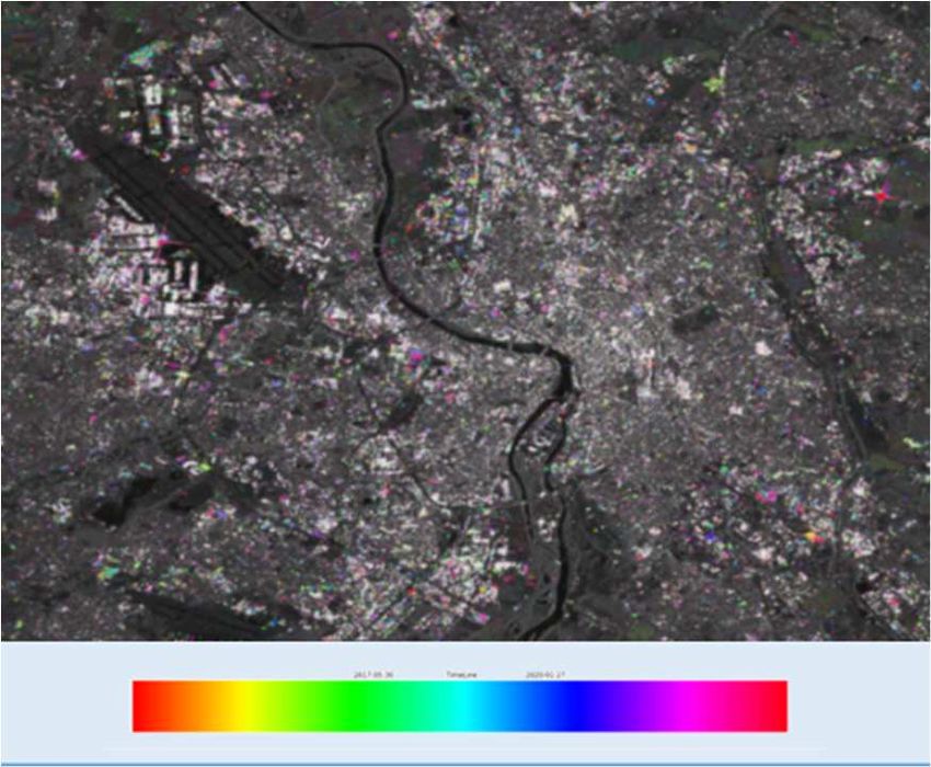
The International Archives of the Photogrammetry, Remote Sensing and Spatial Information Sciences, Volume XLIII-B2-2021
XXIV ISPRS Congress (2021 edition)
advantage of its powerful Data Processing platform2, and
accessing a wide range of satellite images and analysis ready
data[5] (PEPS, THEIA, SWH, etc.) but also datasets such as
SPOT6/7 or Pleiades-HR from AIRBUS OneAtlas, aerial
data from ONERA or cartographic references from IGN.
3.3 Scalability and automation
Deep data analytics work involves multiple steps that are
mostly done manually, in a sequential way, that prevents
mass production.
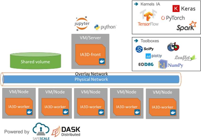
We work on a two level parallel software architecture.
The higher level relies on an orchestrator3 that manages the
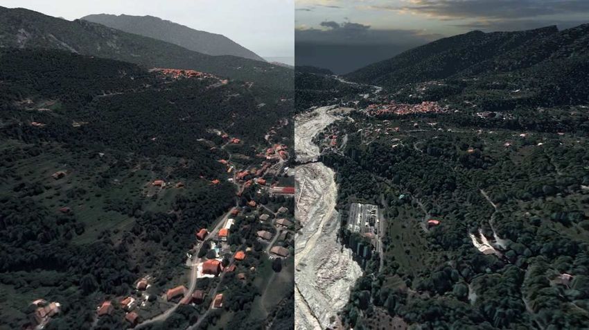
Fig. 4. QUB 3D multi temporal scene – Split view of 2019 &
2020 Vésubie valley (flood damages on the right picture) automation of the full workflow as well as the coarse grain
parallelism. This data parallelism is based on Inputs that are
consistent and independent. Thanks to a workflow modeler
3.2 Platform layer illustrated in Fig. 6. and building blocks offering a standard
At system level, the VRE relies on the Docker container API, scientists can seamlessly design their own automated
technology. In addition to bringing substantial simplification pipeline.
of the deployment process, the Docker inheritance capability
allows to provide each community with the right
environment. The kernel VRE includes common packages of
data science and tools whose versions are compatible with
each other, on top of which multiple thematic overlays
(Imagery, Hydrometry, etc.) have been created. At last, a
specific Project can also add its own overlay to embed
dedicated libraries, specialized tools and so on.
Finally, at infrastructure level, the VRE is based on
Safescale platform developed by CS Group1 that manages of Fig 6. Zeebe workflow modeler
security and interoperability. The VRE is able to seamlessly
work on academic HPC cluster or on Public Cloud. The orchestrator is able to launch a full pipeline taking
into account specialized hardware placement when needed by
building blocks (for instance GPU for training and inference
steps). It also takes care of failure resiliency and provides
processing monitoring information.
At lower level, each building block could, if needed,
implement a fine grain parallelism. To do so, we rely on the
Dask4 processing framework. We chose Dask for its reduced
learning curve, its native Python integration and the multivel
parallelism it offers. Indeed, one can choose multi cores or
multi nodes parallelism depending on the computing cycles
greediness of the algorithm developed.
High level orchestration studies are underway but we
obtained promising first results on automated production.
Fig. 5. Framework architecture
In the frame of AI4GEO project, this environment has
been deployed onto CNES Computing Center taking
1 3
https://github.com/CS-SI/SafeScale https://github.com/zeebe-io/zeebe-modeler
4
2
https://www.hpcwire.com/off-the-wire/cness-data-processing-centre- https://dask.org/
increases-capacity-and-reaches-15th-place-in-io500-ranking/
This contribution has been peer-reviewed.
https://doi.org/10.5194/isprs-archives-XLIII-B2-2021-817-2021 | © Author(s) 2021. CC BY 4.0 License. 819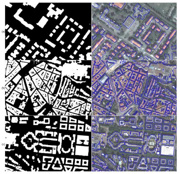
The International Archives of the Photogrammetry, Remote Sensing and Spatial Information Sciences, Volume XLIII-B2-2021
                                                    XXIV ISPRS Congress (2021 edition)

              4. FIRST RESULTS AND OUTLOOK                                Lidar data [6] to handle photogrammetric DSM and
                                                                          scalability. The idea of the algorithm is to let fall a rigid cloth
The 4-year project aspires to produce automatically 3D
                                                                          to cover the inverted surface. The high frequency distortions
semantic maps at very high resolution and global scale. Two
                                                                          of DSM are therefore filtered whereas the low frequency
pipelines have been deployed in the platform during the first
                                                                          variations of ground altitude are captured. At last, the Digital
year.
                                                                          Height (DHM) model is obtained.
4.1 3D Pipeline                                                               Then the Pleiades spectral bands (Red, Green, Blue, Near
                                                                          Infrared), the DHM, and two additional NDVI and C3
                                                                          (shadow) channels are combined into a Tensor. The building
                                                                          semantic segmentation process is performed using a U-Net
                                                                          architecture with an EfficientNet encoder and RefineNet
                                                                          decoder. The neural network is trained by using labels that
                                                                          comes from freely available OpenStreetMap and IGN
                                                                          Databases.
                                                                             Once extracted semantic building regions are obtained,
                                                                          the following step is to perform a morphological post
                                                                          processing which consists of removing too small buildings
                                                                          (when its area in pixels in lower than a user given threshold)
                                                                          and also too small inner courtyards. Then, a connected
                                                                          component segmentation is carried out in order to identify
                                                                          uniquely each building.
                                                                             Finally, a RANSAC regularization method with
                                                                          geometric constraints improvements specific for building
                                                                          shapes, considering the parallelepiped shape of buildings, is
                                                                          applied to obtain the LOD0 (Level Of Detail 0) shape of each
                                                                          building based on the CityGML standard5.
                                                                              The next step consists of computing the LOD1 (flat roof)
                                                                          3D reconstruction of buildings. Thanks to the DHM,
                                                                          statistical height measures such as the minimum, maximum,
                                                                          mean or median are computed for of each building and then
                                                                          3D meshes are constructed for each one.
                           Fig. 7. 3D pipeline                               Ongoing work is focusing on exploring algorithms to
   The first one consists in extracting building footprints as            determine the roof shape of each building in order to compute
well first 3D reconstructions using both Digital Surface                  a LOD2 3D reconstruction. To do so, roof faces need to be
Model (DSM) and images from Pleiades-HR satellites.                       identified. Two methods have been applied: an unsupervised
                                                                          segmentation (Mean-Shift) and a supervised approach based
    The pipeline described in Fig. 7 and illustrated in Fig 8,            on a MASK-RCNN deep learning model to identify each roof
starts with CARS [6][7], an open source stereo pipeline                   face. The spatial arrangement of each roof facet for one
designed for scalability and robustness. Each stereoscopic                building is then compared to a bank of standard roof types
pair of images are converted in epipolar geometry and a                   and the closest one is selected as a better approximation.
disparity map is computed based on Semi Global Matching                   Current results are not convincing. This is mainly explained
algorithm [8]. From this map, homologous points are found                 by the spatial resolution of Pleiades-HR satellite images
in sensor geometry. Then, using forward sensor model (RPC)                where building contours and ridges are often blurred. The
lines of sight related to this points are computed. 3D points             future very high resolution optical satellite images Pleiades
are obtained at the intersection of these lines (barycenter).             Neo will be a perfect opportunity to further assess our LOD2
Finally, a rasterization process is applied to get a                      reconstruction methods.
georeferenced DSM raster.
   The second step of the pipeline aims at extracting the
Digital Terrain Model (DTM) from the DSM at large scale
using a specific module called Bulldozer. This algorithmic
module is an improvement of the original method based on

5
    https://www.ogc.org/standards/citygml

                                                     This contribution has been peer-reviewed.
                      https://doi.org/10.5194/isprs-archives-XLIII-B2-2021-817-2021 | © Author(s) 2021. CC BY 4.0 License.             820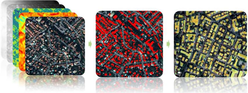
The International Archives of the Photogrammetry, Remote Sensing and Spatial Information Sciences, Volume XLIII-B2-2021
                                                 XXIV ISPRS Congress (2021 edition)

Fig. 8. 3D pipeline: Inputs (PHR multiview, C3, NDVI),
intermediate extracted building, LOD0, LOD1 and finally             Figure 9: Building segmentation from U-Net
LOD2 (first results).                                               RGBNir+DHM+NDVI+C3 and LOD0 regularization on
                                                                    (a) Toulouse and (b,c) Montpellier. Left: extracted
    The training step consists of using 90,000 buildings over
the city of Toulouse. The full dataset has been split into a        buildings; right: True Ortho image with regularized
training dataset (80%), a validation dataset (10%) and a test       building boundaries in blue
dataset (10%). The performance of the pipeline has been
measured on the test dataset. The performance of the U-Net          4.2 Land cover and detection change pipeline
is summarized in table 1:                                           The second pipeline aims at producing land cover with first
                                                                    attempts on change detection. Two different scales are
     Table 1. Semantic segmentation performance                     targeted, VHR on urban tiles (50cm GSD based on Pleiades
   Accuracy Mean F1Score Precision Recall                           images) and HR on regional ones (10m GSD based on
               IOU                                                  Sentinel 2 images).
   0.9333      0.818   0.835     0.895     0.782
                                                                       Urban land cover map contains 4 classes (building,
  Table 2. gives the performance of the regularization              vegetation, water and roads). Semantic segmentation is based
method is computed using 3 metrics:                                 on U-Net neural network trained on a mix of OSM data (95%)
• IoU to evaluate the location and the global shape                 and manual annotations (5%). Fig. 10 presents the Toulouse
    accuracy                                                        land cover produced in 2020.
• Ratio of the number of segments (between the resulted
    shape and the reference shape) to evaluate the simplicity
    of the resulted building shape
• The difference of the orientation of the minimum
    oriented bounding box between the resulted shape and
    the reference one.

          Table 2. Regularization performance
                            Mean             Standard dev
 IoU                        0.692                 0.11                     Fig. 10. City scale (Toulouse) land cover 2020
 Ratio segments              1.81                 0.86                 Analysis of the preliminary results has quickly pointed out
 Orientation               0.15 rad             0.09 rad            a performance limitation due to multiple bias included in the
                                                                    ground truth (GT), especially when considering alignment of
   Fig. 9 shows other areas that have been produced with            object edges (highlighted by Intersection over Union, IoU,
equivalent results such as the city of Montpellier and              metric) even if the classification itself is good (overall
Barcelone.                                                          accuracy above 0.85). Therefore, an activity on labelling
                                                                    tools has been started with two main axes. On the one hand a

                                               This contribution has been peer-reviewed.
                https://doi.org/10.5194/isprs-archives-XLIII-B2-2021-817-2021 | © Author(s) 2021. CC BY 4.0 License.            821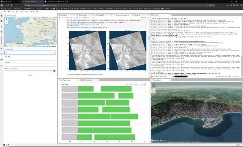
The International Archives of the Photogrammetry, Remote Sensing and Spatial Information Sciences, Volume XLIII-B2-2021
                                                 XXIV ISPRS Congress (2021 edition)

labelcooker tool aims to merge existing GT by combining the                               5. CONCLUSION
best characteristics of each (through a statistical approach).
                                                                        In this paper the AI4GEO project has been presented and
On the other hand, a semi-automatic method is developed in
                                                                    some of its first achievement reviewed. Many other research
autolabel tool, that intend to produce new GT, using active
                                                                    activities have been carried out within partner labs so as to
learning approach in order to increase labelling productivity.
                                                                    launch the second year of the project. Our goal will be to
   Global land cover map is made up of 14 classes, subset           tackle new challenges towards the Global Smart Map, such
of Corine Land Cover. It is based on Sentinel2 sensor. Best         as performance optimization and generalization on a wide
results are obtained with a ResNet network on Sentinel2 L1C         range of cities and regions (Asia, America, etc.), multi
time series, trained with IGN OSC-GE dataset. Fig.11 shows          resolution classification, change detection, 3D mesh
the PACA land cover map produced at the end of 2020 with            reconstruction and from a platform point of view, workflow
a 0.89 overall accuracy score. Recent researches are now            orchestration at large scale to cope with the global scale
focusing on multi resolution inputs with the objective to           objective.
benefit from the resolution of a THR sensor (Spot6/7 or PHR)
                                                                                          6. REFERENCES
and from the revisit frequency and multispectral information
of HR Sensor (Sentinel2).                                           [1] Lebègue, L. & Cazala-Hourcade, E. & Languille, F. &
                                                                    Artigues, S. & Melet, Olivier. (2020). CO3D, A
                                                                    WORLDWIDE ONE ONE-METER ACCURACY DEM
                                                                    FOR 2025. ISPRS - International Archives of the
                                                                    Photogrammetry, Remote Sensing and Spatial Information
                                                                    Sciences. XLIII-B1-2020. 299-304. 10.5194/isprs-archives-
                                                                    XLIII-B1-2020-299-2020.

                                                                    [2] Baillarin, S. & Tinel, Claire & Lassalle, Pierre & Melet,
                                                                    Olivier & Youssefi, David & Kettig, Peter & Poughon, V. &
                                                                    Gaudissart, Vincent. (2019). Perspectives for VHR Big Data
                                                                    Image Processing and Analytics Toward a Dedicated
         Fig. 11. Region scale (PACA) land cover                    Framework for Major Disaster and Environment Monitoring
    As regards the detection change, the ONERA REACTIV              from Space. 5401-5404. 10.1109/IGARSS.2019.8900159.
Tool (Rapid and Easy Change Detection in RADAR Time-
series by Variation coefficient) was integrated on the              [3] M. Darques et al. “AI4GEO Engine: a hybrid HPC/Cloud
AI4GEO platform. As detailed in [10], changes are                   AI oriented platform for Earth-wide EO data processing”,
highlighted in SAR time series by analyzing the Variation           Proc. of BiDS'21
coefficient. It provides change visualization capability by
colorizing pixels depending on change detection date.               [4] V. Gaudissart et al. “EODAG: an Open Source Earth
Furthermore, it is possible to discriminate between one-time        Observation Data Access Gateway”, ESA Phi-Week 2019,
and persistent change. Fig. 12 shows the Toulouse change            https://github.com/CS-SI/eodag
detection map produced using a Sentinel1 time series from
2017 to 2020.
                                                                    [5] P. Kettig et al., “Developing image processing chains for
                                                                    the THEIA land data Centre to Provide Near Real Time
                                                                    image products”, Big Data from Space 2019, Munich.

                                                                     [6] Youssefi, David & Michel, Julien & Sarrazin,
                                                                    Emmanuelle & Buffe, Fabrice & Cournet, Myriam & Delvit,
                                                                    Jean-Marc & L'Helguen, Celine & Melet, Olivier & Emilien,
                                                                    Aurelie & Bosman, Julien. (2020). CARS: A
                                                                    Photogrammetry Pipeline Using Dask Graphs to Construct A
                                                                    Global            3D          Model.            453-456.
                                                                    10.1109/IGARSS39084.2020.9324020.
                                                                    https://github.com/CNES/cars

                                                                    [7] Michel, J. & Sarrazin, E. & Youssefi, David & Cournet,
                                                                    Myriam & Buffe, F. & Delvit, J. & Emilien, A. & Bosman, J.
                                                                    & Melet, Olivier & L’Helguen, C.. (2020). A NEW
     Fig. 12. Change detection on Toulouse 2017-20                  SATELLITE IMAGERY STEREO PIPELINE DESIGNED

                                               This contribution has been peer-reviewed.
                https://doi.org/10.5194/isprs-archives-XLIII-B2-2021-817-2021 | © Author(s) 2021. CC BY 4.0 License.            822
The International Archives of the Photogrammetry, Remote Sensing and Spatial Information Sciences, Volume XLIII-B2-2021
                                                XXIV ISPRS Congress (2021 edition)

FOR       SCALABILITY,          ROBUSTNESS           AND
PERFORMANCE. ISPRS Annals of Photogrammetry,
Remote Sensing and Spatial Information Sciences. V-2-2020.
171-178. 10.5194/isprs-annals-V-2-2020-171-2020.

[8] Hirschmüller, Heiko. (2008). Stereo Processing by Semi-
Global Matching and Mutual Information. in IEEE
Transactions on Pattern Analysis and Machine Intelligence.
30. 328-341.

[9] Zhang, Wuming & Qi, Jianbo & Peng, Wan & Wang,
Hongtao & Xie, Donghui & Wang, Xiaoyan & Yan,
Guangjian. (2016). An Easy-to-Use Airborne LiDAR Data
Filtering Method Based on Cloth Simulation. Remote
Sensing. 8. 501. 10.3390/rs8060501.

[10]      Koeniguer, Elise & Nicolas, Jean-Marie. (2020).
Change Detection Based on the Coefficient of Variation in
SAR Time-Series of Urban Areas. Remote Sensing. 12. 2089.
10.3390/rs12132089.
https://github.com/elisekoeniguer/REACTIV

                                              This contribution has been peer-reviewed.
               https://doi.org/10.5194/isprs-archives-XLIII-B2-2021-817-2021 | © Author(s) 2021. CC BY 4.0 License.            823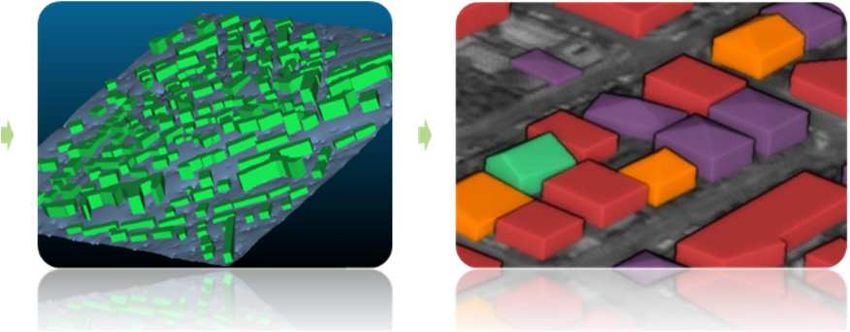

You can also read


