The Jurassic Gorgo a Cerbara palaeoescarpment (Monte Nerone, Umbria-Marche Apennine): modelling three-dimensional sedimentary geometries - Journal ...
←
→
Page content transcription
If your browser does not render page correctly, please read the page content below
doi: 10.3304/JMES.2019.004                                                       Journal of Mediterranean Earth Sciences 11 (2019), xx-xx

                                             Journal of Mediterranean Earth Sciences


The Jurassic Gorgo a Cerbara palaeoescarpment (Monte Nerone, Umbria-Marche
       Apennine): modelling three-dimensional sedimentary geometries

                    Marco Romano 1,2,*, Simone Fabbi 2,3, Paolo Citton 2,4, Angelo Cipriani 2,3

1
    Evolutionary Studies Institute (ESI), School of Geosciences, University of the Witwatersrand, Johannesburg, South Africa
                                                   2
                                                     A-Team (Apennine Team)
                     3
                       Dipartimento di Scienze della Terra, SAPIENZA Università di Roma, Rome, Italy
              4
                CONICET-Consejo Nacional de Investigaciones Científicas y Técnicas, Buenos Aires, Argentina
                                    *
                                      Corresponding author: marco.romano.univ@gmail.com

  ABSTRACT - In the last decades, methodologies for three-dimensional digitisation of geological outcrops have
considerably grown. These methods provide to geologists powerful tools to collect, manipulate and communicate field
evidence through the reconstruction of high-resolution digital models, starting from a considerable amount of raw
data. Among the different methods and technologies, high-resolution Digital Photogrammetry has proven to be among
the most economical and performing methods, with several applications in the field of geology sensu lato, including
outcrop visualisation, geological site management, sedimentology, palaeontology, structural geology, geomorphology
and applied geology. In this contribution, we applied high-resolution Digital Photogrammetry to a key-outcrop from
the Umbria-Marche Apennines. The studied site is at Gorgo a Cerbara (Piobbico, PU), where the NW-facing Jurassic
escarpment of the Monte Nerone Pelagic Carbonate Platform (PCP) is spectacularly exposed. Starting from a suitable
number of photographic images of the outcrop taken from different perspectives, we reconstruct a high-definition 3D
digital model of the exposed palaeoescarpment. The obtained models provide peculiar sedimentological, taphonomical
and stratigraphical details, thus facilitating the comprehension of the complex sedimentary evolution of a PCP margin.
3D modelling allows to observe and display the geological features from ideally infinite perspectives, helping in the
reconstruction, understanding and communication of complex three-dimensional geometries in a more direct and
objective way.

 Keywords: Pelagic Carbonate Platforms; photogrammetry; 3D modelling; sedimentary geometries; Umbria-Marche
Apennines; Jurassic.

                                         Submitted: 13 April 2019 - Accepted: 12 June 2019

1. INTRODUCTION                                                     geological contexts, such as laser scanning (e.g. Rowlands
                                                                    et al., 2003; Rosser et al., 2005; Buckley et al., 2008,
   In the last years, three-dimensional digitisation of             2010; McCoy et al., 2010; Hodgetts, 2013) and LiDAR
geological outcrops got an increasing consideration.                technology (e.g. Bellian et al., 2005; Cunningham et
Up to date, different methodologies allow geologists to             al., 2006; Schulz, 2007; Burton et al., 2011; Hartzell et
collect, manipulate and communicate field evidence by               al., 2014), high-resolution Digital Photogrammetry is
means of highly resolved digital models, reconstructed              proving to be by far the easiest and cheapest method.
from a considerable amount of raw data. In addition,                Despite photogrammetry has used with a pioneering
3D models enable digital preservation of key outcrops               approach since the 1970s, recently this technique is
with regional and global significance, especially if the            increasingly applied in different fields of the geological
sites could be irreversibly modified by human action or             sciences sensu lato. This revival is essentially due to the
by natural processes of geomorphological evolution (see             development of new technologies, availability of more
Cipriani et al., 2016).                                             powerful cameras, processors and high-performance
   Although over time several methods and technologies              software. Compared to other methods such as laser
have been proposed and applied for 3D modelling of                  scanning, digital photogrammetry has the advantage of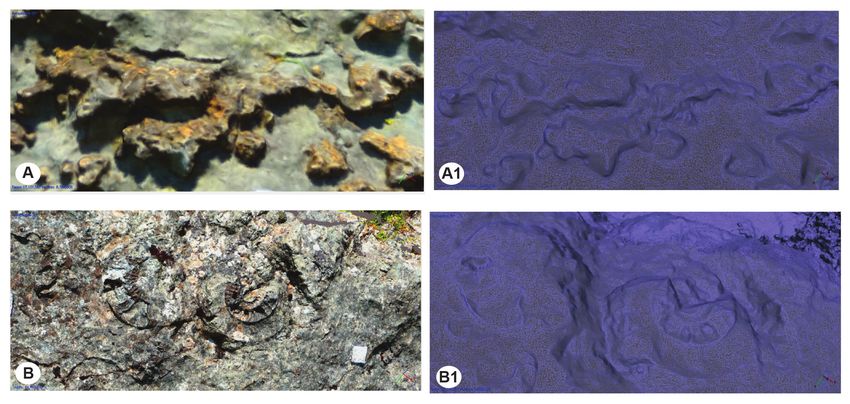
2                              M. Romano et al. / Journal of Mediterranean Earth Sciences 11 (2019), xx-xx

being much more economical and accessible, essentially                 complex three-dimensional geometries, and to digitally
needing only a camera and appropriate software, some                   preserve crucial outcrops frequently involved in
also available as open source (see Falkingham, 2011;                   irreversible natural and anthropic processes of geological
Cipriani et al., 2016). This has recently led to numerous              and geomorphological evolution.
uses of photogrammetry in geology, providing additional
and powerful tools for interpreting outcrops and for                   2. GEOLOGICAL SETTING
communicating the results to the scientific community
more objectively. To date, photogrammetric models                         The study area is located in the northern sector of
have been used for outcrop visualisation, geological                   the Umbria Marche Apennines (Fig. 1), belonging
site management, and study of peculiar setting from                    to the Umbria-Marche-Sabina Geological Domain,
different geological features, including sedimentology,                characterised by a thick Upper Triassic-to-Neogene
structural geology, geomorphology and applied geology                  stratigraphic succession, whose stratigraphic evolution
(e.g. Chandler and Moore, 1989; Lane et al., 1993; Oka,                is widely described in literature (Farinacci, 1967;
1998; Hapke and Richmond, 2000; Mora et al., 2003;                     Colacicchi et al., 1970; Centamore et al., 1971; Galluzzo
Walstra et al., 2007; Baldi et al., 2008; Sturzenegger and             and Santantonio, 2002; Pierantoni et al., 2013; Fabbi,
Stead, 2009; Cachao et al., 2011; Westoby et al., 2012;                2015; Cipriani, 2016). In the earliest Jurassic, the area was
Lato et al., 2013; Martín et al., 2013; Bemis et al., 2014;            occupied by a vast peritidal carbonate platform (“Calcare
Fan and Li, 2015; Cipriani et al., 2016; Vollgger and                  Massiccio” platform; Calcare Massiccio Fm in Petti et al.,
Cruden, 2016; Hayes et al., 2018; Zimmer et al., 2018).                2007), which was dismembered by extensional tectonics
In the field of palaeontology, photogrammetry has been                 since the Hettangian (Bernoulli, 1967; Bertotti et al., 1993;
used to describe new specimen and taxa and to obtain                   Centamore et al., 1971; Colacicchi et al., 1970; Farinacci
in-vivo reconstruction starting from 3D model in both                  et al., 1981; Santantonio and Carminati, 2011; Fabbi and
invertebrates and vertebrates (Wiedemann et al., 1999;                 Santantonio, 2012). Such extensional phase produced
Brassey et al., 2015; Brassey, 2016; Fau et al., 2016;                 an articulated submarine topography, causing the
Vidal and Díaz, 2017; Romano et al., 2018a, 2018b,                     diachronous drowning of the benthic carbonate factory
2019a, 2019b; Cipriani et al., 2019; Citton et al., 2019;              and the consequent onset of pelagic sedimentation on
Rubidge et al., 2019). A field where photogrammetry is                 both horsts and grabens (Morettini et al., 2002; Passeri and
providing very promising results is vertebrate ichnology,              Venturi, 2005). The hangingwall basins of Jurassic faults
being a powerful tool both for the detailed analysis and               experienced rapid tectonic subsidence, and, starting from
description of new ichnotaxa and to make inferences                    the Sinemurian, were filled by a thick (several hundred
about biomechanics and locomotion based on differential                meters) Jurassic-Early Cretaceous pelagic succession,
depth of impression obtainable from the high-resolution                composed of resediment-rich cherty limestones, marls
3D models (e.g. Petti et al., 2008, 2018; Remondino et al.,            and cherts. Differently, the footwall blocks remained at
2010; Falkingham, 2011; Romilio and Salisbury, 2014;                   shallow depth, since small relics of “Calcare Massiccio”
Lallensack et al., 2015; Citton et al., 2015, 2017a, 2017b,            carbonate platforms (“Calcare Massiccio B” in Centamore
2018; Lockley et al., 2016; Razzolini et al., 2016; Romano             et al., 1971; Calcare Massiccio B member in Petti et al.,
and Citton, 2016; Lužar-Oberiter et al., 2017; Belvedere et            2007; “drowning succession of the footwall blocks” in
al., 2018; Falkingham et al., 2018; Warnock et al., 2018).             Marino and Santantonio, 2010) survived until the earliest
   In the present contribution, we discuss a 3D digital model          Pliensbachian, when they simultaneously drowned due
of a peculiar geological setting in the Umbria-Marche-                 to perturbation of oceanic water conditions (Morettini
Sabina Domain (UMS-Central/Northern Apennines,                         et al., 2002; Franceschi et al., 2014, Masetti et al., 2016),
Italy) produced by means of high-resolution digital                    in a passive post-tectonic regime (Santantonio and
photogrammetry. The well-exposed portion of a Jurassic                 Carminati, 2011; Santantonio et al., 2017). After the early
submarine escarpment unconformably covered by pelagic                  Pliensbachian, thus, the footwall blocks of Jurassic faults
and neritic deposits, bounding the Monte Nerone Pelagic                represented intrabasinal morphostructural highs known
Carbonate Platform (PCP sensu Santantonio, 1994), was                  as PCPs (Santantonio, 1993, 1994; Santantonio et al.,
analysed.                                                              2017), as they host a very thin (up to few tens of meters),
   The obtained photogrammetric models return with                     Jurassic-Lower Cretaceous chert-free and fossil-rich
high definition and detail the peculiar sedimentological,              pelagic succession (Bugarone Group, Cecca et al., 1990),
taphonomical, palaeontological and stratigraphical                     coeval with the thicker basinal one (Fig. 2A).
framework observed in the field. The interpretation of                    Steep escarpments, representing inactive vestiges of
the models allows communicating, in a simple and direct                roofed Early Jurassic faults, connected the top of PCPs
way, the complex stratigraphic-sedimentological features               with the surrounding deeper basins. Palaeoescarpments
of a PCP margin and the processes triggered within PCP/                were the sites of stratigraphic contacts, as testified by the
basin systems. The opportunity to display the obtained                 onlap unconformities of the pelagic succession passively
models from a theoretically infinite different perspectives            filling the basin onto the pre-rift “Calcare Massiccio” unit
represents a powerful tool for further helping in the                  exposed along the rift-related scarps. Jurassic escarpments
reconstruction, interpretation and communication of                    commonly host ponded patches of condensed pelagites
M. Romano et al. / Journal of Mediterranean Earth Sciences 11 (2019), xx-xx                          3

Fig. 1 - Location and simplified geological map of the Mt. Nerone-Mt. Catria ridge. 1) Calcare Massiccio Fm.; 2) Bugarone Group; 3)
Jurassic basinal succession; 4) Maiolica Fm.; 5) Aptian - Oligocene deposits; 6) Miocene - Recent deposits; 7) main thrust faults; 8)
strike slip fault (Modified after Romano et al., 2019c).

(epi-escarpment deposits sensu Galluzzo and Santantonio,                 palaeotopographic irregularities were generally blanketed
2002) locally sedimented within small favourable                         by the Maiolica Fm in the earliest Cretaceous, albeit with
morphologies (i.e. mesotopographical lows as collapse                    localised phases of revived tectonics (e.g. Fabbi, 2015;
niches of detached blocks), in otherwise non depositional                Fabbi et al., 2016; Cipriani, 2016, 2017; Romano et al.,
slopes (Santantonio et al., 2017). Significantly, the                    2018b; Cipriani and Bottini, 2019a, 2019b).
birth of palaeoescarpments in the earliest Sinemurian                       The study outcrop (lat. 43°35’28’’N, long. 12°32’21’’E)
predates the drowning of the “Calcare Massiccio B”-                      is in the deeply-incised valley of the Candigliano River,
type carbonate platforms at the top of PCPs (Fabbi and                   close to the Gorgo a Cerbara quarry (less than 3 km E
Santantonio, 2012). The latter implies that Sinemurian-                  of Piobbico-Pesaro-Urbino, Marche) (Fig. 1). Gorgo a
earliest Pliensbachian palaeoescarpments could host                      Cerbara is a classical section for the Jurassic of the UMS
both sparse patches of resedimented “Calcare Massiccio                   Domain (e.g. Elmi, 1981; Immerz, 1985; Cecca et al., 1987,
B” and patches of Sinemurian condensed pelagites (i.e.                   1990; Kälin and Ureta, 1987; Cresta et al., 1989; Marino
older than the typical Bugarone Group – Fig. 2B). At the                 and Santantonio, 2010) and is part of the Monte Nerone
stratigraphic unconformable contact with the silica-rich                 PCP/basin system. Monte Nerone represents one of the
basinal pelagic succession, both the “Calcare Massiccio”                 largest PCPs of the UMS and is a particularly representative
and any interposed epi-escarpment deposit are often                      site for Jurassic palaeontology and sedimentology (e.g.
silicified (Santantonio et al., 1996); silicification is indeed          Centamore et al., 1971; Farinacci et al., 1981; Alvarez,
an important feature for recognising stratigraphic (rather               1989a, 1989b; Cecca et al., 1990; Mariotti, 2003; Romano et
than tectonic) boundaries such as palaeoescarpments                      al., 2018b, 2019c; Cipriani et al., 2019; Citton et al., 2019),
(Galluzzo and Santantonio, 2002; Di Francesco et                         as it was studied since the XIX century (Zittel, 1870). The
al., 2010; Santantonio et al., 2017). Regionally, the                    NW-facing margin of this Jurassic morphostructural high
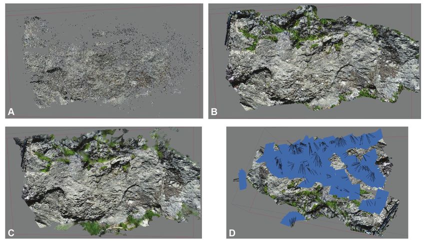
4                                M. Romano et al. / Journal of Mediterranean Earth Sciences 11 (2019), xx-xx

Fig. 2 - A) General stratigraphic setting and main features of a Jurassic PCP-basin system in the UMS Domain (Modified after Santantonio
et al., 2017); B) Schematic reconstruction of the Monte Nerone PCP and Gorgo a Cerbara palaeoescarpment in the Sinemurian-early
Pliensbachian.

is spectacularly exposed at Gorgo a Cerbara (Fig. 3). We                 this complex onlap surface. The whole structure is covered
focused the attention on the lower portion of this Jurassic              with an angular unconformity by the basin-fill pelagites of
submarine escarpment, characterised by an irregular,                     the Corniola Fm, “middle”-late Pliensbachian in age.
silicified, palaeo-surface of pre-rift “Calcare Massiccio”.
Small patches of “Calcare Massiccio B”-type facies, late                 3. MATERIAL AND METHODS
Sinemurian-earliest Pliensbachian in age (“unconformity-
bounded drowning succession” in Marino and Santantonio,                    For the production of the photogrammetric model,
2010), and cephalopod-rich pelagites of late Sinemurian                  347 photos of the outcrop were taken from different
(Lotharingian-Cecca et al., 1987) age, in the form of                    angles, trying to always have at least 60% overlap
scattered epi-escarpment deposits, rest unconformably on                 between contiguous photos. The software used is Agisoft
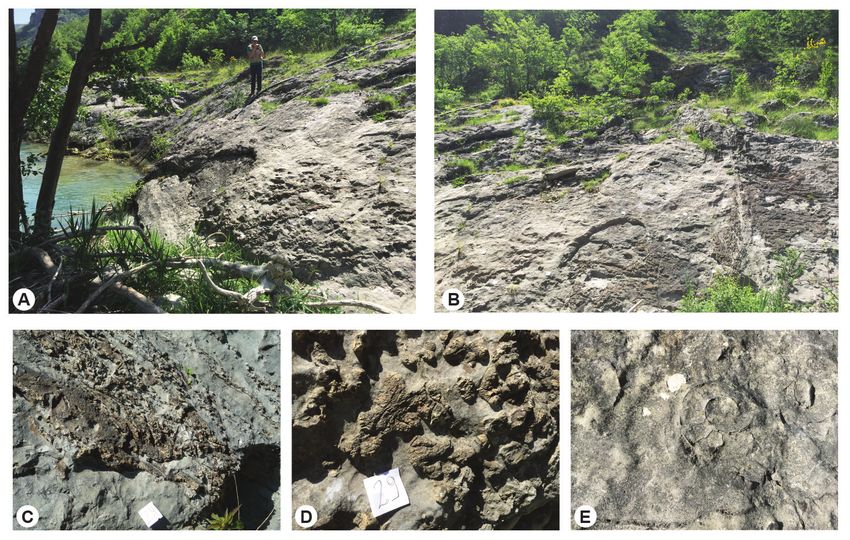
M. Romano et al. / Journal of Mediterranean Earth Sciences 11 (2019), xx-xx                             5

Fig. 3 - A) and B) The Gorgo a Cerbara palaeoescarpment outcrop at Piobbico (PU) bordered by the Candigliano river; C) and D)
details of the irregular, silicified, palaeo-surface of pre-rift “Calcare Massiccio”; E) section of a large ammonite in the upper Sinemurian
epi-escarpment deposits made of condensed Corniola-type (diametre: 22 cm).

PhotoScan Standard Edition, version 1.4.0 (Educational                    the almost final result of the model (Fig. 4B). In the last
License), which enables automatic generation of point                     step a mesh was generated starting from the dense point
clouds, polygonal models, georeferenced orthomosaics,                     cloud, i.e. a complex polygonal surface made of vertices
textured and DSMs/DTMs from still images. High-                           and faces on which the program literally smears the raster
resolution Digital Photogrammetry is based on Structure                   of the photo (Fig. 4C).
from Motion (SfM) (Ullman, 1979) and Multi View                              The models obtained with Agisoft PhotoScan can be
Stereo (MVS; Seitz et al., 2006) algorithms, with an                      exported in numerous formats, including “.OBJ” and
accuracy for close-range photography in the obtained                      “.PLY”, the latter preferable because it also retains the
models of up to 1 mm. Geometrically the software needs                    raster data of the original photos on the final product.
only three photos from different angles for each single                   The file exported as .PLY can be opened with the open
point for the reconstruction of its position in space;                    source software MeshLab, which allows numerous
however, for extensive subjects, such as large surfaces,                  interesting actions and modifications, including the
more than 200 shots are needed to make sure that every                    isolation of individual volumes and the measurement of
single point has been covered, without shaded or hidden                   different objects. The final reconstructed model consists
objects or surfaces portions. The repeated overlap does                   of approximately 8 million vertices and 17 million faces.
not generate noise, rather the redundancy could add a lot                 This means that an outcrop surface of approximately 9
of information for the final dense clouds.                                square meters can be represented by a polygonal mesh
  The photos were aligned in the software using the                       with about 190 faces per square centimetre, a resolution
function “Align Photos” which led to the construction                     that is more than acceptable for the purposes of the
of the initial “Spars Point Cloud” (Fig. 4A). Then, several               present contribution.
steps have been conducted to calibrate the cameras                           The studied outcrop was analysed directly in situ,
and to reduce the errors due to “reprojection error”,                     using the classic methodologies of the field geology. A
“reconstruction uncertain” and “projection accuracy”.                     lithostratigraphic approach combined with facies analysis
The subsequent phase consisted in the reconstruction                      allowed to recognise different facies associations and to
of the “Dense Cloud”, where the missing points among                      describe the depositional setting of the palaeoescarpment,
those acquired in the model are geometrically and                         as well as its space-time evolution. Several rock samples
mathematically reconstructed. This phase leads to the                     were analysed first hand and collected to produce several
dense point cloud where it is already possible to appreciate              thin sections. Microscopical analysis of the samples
6                                 M. Romano et al. / Journal of Mediterranean Earth Sciences 11 (2019), xx-xx

Fig. 4 - Reconstruction of the 3D model in Agisoft PhotoScan Standard Edition, version 1.4.0 (Educational License). A) Initial “Spars Point
Cloud” after photos alignment; B) “Dense Cloud” after correction for “reprojection error”, “reconstruction uncertain” and “projection
accuracy”; C) Final mesh of the model made of approximately 8 million vertices and 17 million faces; D) Final mesh with the indication
of the angles from which the photos were taken.

Tab. 1 - Main features of the different facies recognised in the Gorgo a Cerbara palaeoescarpment.

                                                                                                                        Depositional
    Sample   Lithostratigraphic unit                   Microfacies description                             Age
                                                                                                                          setting

                                           Bioclastic grainstone bearing peloids, micritic                              High energy,
                                        grains, cortoids, algal nodules, benthic foraminifers                             peritidal,
    AC 808    Calcare Massiccio Fm                                                                     Hettangian
                                             and microproblematica (Thaumatoporella                                    shallow marine
                                           parvovesiculifera, Lithocodium sp.) (Fig. 5D).                               environment

                                         Bioclastic packstone with microoncoids, peloids,
               Calcare Massiccio B                                                                                       Submarine
    AC 809                               abundant micritic portion, sponge spicules and             Sinemurian p.p.
                    member                                                                                               escarpment
                                                   benthic foraminifers (Fig. 5E).

                                         Bioclastic floatstone with ammonites, gastropods,
                 “Corniola”-type
                                          siliceous sponge spicules, benthic foraminifers,                               Submarine
    AC 807       condensed epi-                                                                     Sinemurian p.p.
                                         radiolarians and undeterminable bioclastic debris                               escarpment
               escarpment deposit
                                                               (Fig. 5F)

                                         Mudstone/floatstone with crinoids, radiolarians,
                                                                                                     “middle”-late
    AC 810        Corniola Fm           siliceous sponge spicules, benthic foraminifers and                             Basin margin
                                                                                                     Pliensbachian
                                                       ammonites (Fig. 5G).

allowed to better define every single facies and to recognise             4. PHOTOGRAMMETRIC MODEL
in detail the limits between the different sedimentary
bodies. Microfacies description of the outcropping                          Figure 5 shows the model obtained from three different
lithotypes followed the classification of Dunham (1962)                   points of view. In the model shown in figure 5A, the
and Embry and Klovan (1971), is summarised in table 1.                    3D reconstruction does not seem to deviate much from
Microphotographs of the thin sections are in figure 5.                    simple photography, however once the individual units
M. Romano et al. / Journal of Mediterranean Earth Sciences 11 (2019), xx-xx 7 Fig. 5 - Final model of the Gorgo a Cerbara palaeoescarpment outcrop. A, B, C) Mesh model with the original texture; A1, B1, C1) final mesh with the different recognised facies indicated by different colors: pre-rift “Calcare Massiccio” in purple, epi-escarpment deposits with “Calcare Massiccio B”-type facies in light blue, epi-escarpment deposits made of condensed Corniola-type in orange, well-bedded basinal pelagites of the Corniola Fm in light yellow; D) pre-rift “Calcare Massiccio” in thin section. Sample AC 808; E) “Calcare Massiccio B”-type epi-escarpment deposits in thin section. Note the coated grains dispersed in abundant micritic mud bearing sponge spicules and crinoids. Sample AC 809; F) Microphotograph of the epi-escarpment deposits made of condensed Corniola-type facies. Note the high fossil content of the pelagites. Sample AC 807; G) Thin section of the well-bedded and cherty basinal pelagites of the Corniola Fm. The bioclastic pelagic facies are dominated by fragments of crinoids, radiolarians, siliceous sponge spicules and benthic foraminifers. Sample AC 810. See table 1 for the description of the microfacies.
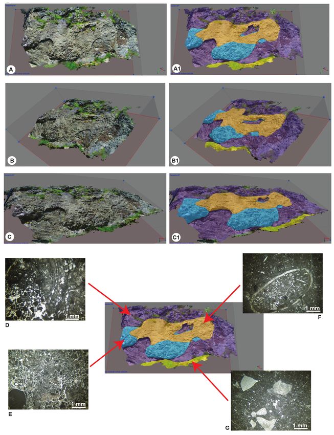
8                                 M. Romano et al. / Journal of Mediterranean Earth Sciences 11 (2019), xx-xx

are isolated and the volumes highlighted with different                   blocks of the horst and graben systems (Galluzzo and
colours, the complex sedimentary situation results much                   Santantonio, 2002; Santantonio et al., 2017). Similarly,
clearer and more evident. The pre-rift “Calcare Massiccio”                such evidence may be a good indicator of olistoliths
representing the Jurassic horst-block is highlighted                      embedded in the basinal succession, with information
in purple (Fig. 5). The epi-escarpment deposits with                      on margin stability at a precise geological time, and
“Calcare Massiccio B”-type facies are highlighted in light                identification of possible tectonic phases (Di Francesco et
blue. The lack of Agerina martana, a characteristic taxon                 al., 2010; Fabbi, 2015; Cipriani, 2016).
of the Pliensbachian facies of the “Calcare Massiccio B”,
allows to speculate a Sinemurian age for these deposits.                  5. DISCUSSION AND CONCLUSIONS
Epi-escarpment deposits made of condensed Corniola-
type facies bearing very large upper Sinemurian                              The present contribution on a peculiar depositional
(Lotharingian) ammonites (Cecca et al., 1987) are                         setting of the UMS Domain enforces the importance of
highlighted in orange. These lithofacies apparently                       photogrammetric models application in geology sensu
cover the older “Calcare Massiccio B” epi-escarpment                      lato. First, these models provide a great contribution
deposits. The well-bedded and cherty basinal pelagites                    in the outcrop visualisation, allowing to identify
of the Corniola Fm are highlighted in light yellow and                    and highlight the geometry of rocky bodies, their
characterise the lower portion of the photogrammetric                     structures and sedimentological features. In addition,
model. The basin-margin Corniola Fm onlaps the pre-rift                   the photogrammetric method allows a more objective
“Calcare Massiccio”, as well as the “Calcare Massiccio B”                 communication of both starting raw data and of particular
and the Lotharingian epi-escarpment deposits, burying                     interpretation provided by authors. The geological
a peculiar Sinemurian-Pliensbachian depositional                          subject can be represented both in its original conditions
architecture. These onlapping deposits caused the intense                 observable in the field, and as interpreted model, in order
and pervasive silicification of the pre-rift “Calcare                     to keep always well-separated the original data from
Massiccio” and of the epi-escarpment deposits. Notably,                   the interpretation by geologists. The integration of the
silicification affected a complex network of fractures                    reconstructed 3D models with the classical field-work
affecting the horst-block “Calcare Massiccio”, freezing                   observations may represents a crucial support for the
rift-related brittle deformations (Fig. 3C, 3D).                          correct interpretation of sedimentary structures, and of
   Significant details of the outcrop, such as the                        geometric relationships between sedimentary bodies.
silica nodules and the fossils, are rendered in the 3D                       In addition, high-resolution Digital Photogrammetry
reconstruction (Fig. 6). Silicification of the Calcare                    allows to preserve a virtual model of crucial and
Massiccio, a field evidence neglected for a long-time,                    paradigmatic geological sites. This is particularly
has proved to be a crucial evidence for recognising                       important for the Gorgo a Cerbara palaeoescarpment, an
palaeoescarpments in the field, i.e. to identify the onlap                important outcrop also from the historical point of view.
contact of the cherty basinal formations on the footwall                  It was indeed one of the first areas where the stratigraphic

Fig. 6 - Significant details of the outcrop very well-returned by the reconstructed 3D model; silicified palaeo-surface of pre-rift “Calcare
Massiccio” and ammonites from the epi-escarpment deposits made of condensed Corniola-type facies as textured meshes (A, B) and
solid models (A1, B1).
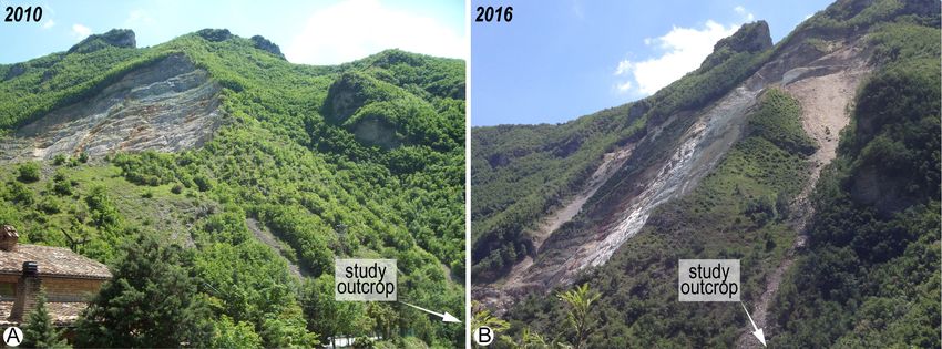
M. Romano et al. / Journal of Mediterranean Earth Sciences 11 (2019), xx-xx                              9

contact between the basin succession and the horst-block                     High-resolution photogrammetric techniques further
“Calcare Massiccio”, along unconformity surfaces (i.e.                    proven to be the most low-cost/high-performance tool
palaeoescarpments), was in fact observed and recognised                   for modelling and visualising in the field of geology
in XIX century. A complex outcrop that, because of its                    sensu lato. Photogrammetry is used to construct wide-
topographic and exposition conditions, can be subject to                  ranging three-and four-dimensional models rooted on
rapid geomorphological evolution and to various kinds                     fieldwork, for visualisation of geological inferences and
and grade of damage, including anthropic intervention.                    reconstructions as well. However, we would like to stress
The lower boundary of the outcrop is in fact lapped by                    how photogrammetry, and in general 3D modelling in
the Candigliano river, which leads to progressive erosion                 geology, cannot and must never replace the work and
especially in the area were the basinal Corniola Fm onlaps                direct analysis of the geologist in the field, but must
the epi-escarpment deposits (Fig. 3A). It is also worth                   remain simple a supporting tool for the regular and
remembering that the Gorgo a Cerbara outcrop is close                     irreplaceable field operations and survey.
to an active quarry. Recently, widening of the excavation
face moved towards the study outcrop; several volumes                        ACKNOWLEDGEMENTS - The Editor in Chief Salvatore Milli
of rocks, resulting from the enlargement of the quarry,                   and the reviewers, Alessio Argentieri and Fabio Massimo Petti
fell along the steep slopes of the Candigliano valley. These              are warmly thanked for their comments and suggestions which
anthropic-derived debris apron have partially covered the                 have substantially improved an early version of the manuscript.
analysed portion of the palaeoescarpment, hiding most                     Part of this work was made possible by financial support to MR
of the stratigraphic and sedimentological peculiarities                   from the DST/NRF Centre of Excellence for Palaeosciences (CoE
showed in this work (Fig. 7). Additional potential sources                in Palaeosciences) and the NRF African Origins Platform, and to
of damage for the site are: i) the vegetation cover, due                  AC from the IAS Post-Graduate Student Grants (2015) and the
to the destructive action over time of humic acids and                    “Avvio alla Ricerca” Project (“Sapienza” Università di Roma, 2015).
root; ii) the effect of cryoclastism; iii) karstification; iv)
possible rockfall processes.                                              REFERENCES
   In conclusion, the use of photogrammetry has
allowed the construction of a highly resolved 3D model,                   Alvarez W., 1989a. Evolution of the Monte Nerone seamount
where individual geological units can be highlighted to                       in the Umbria-Marche Apennines: Jurassic-Tertiary
improve the outcrop visualisation and to make difficult                       stratigraphy. Bollettino della Società Geologica Italiana 108,
sedimentological setting easier to analyse and interpret.                     3-21.
In addition, often a detailed photogrammetric model                       Alvarez W., 1989b. Evolution of the Monte Nerone seamount
can highlight some aspects not noticed initially in the                       in the Umbria-Marche Apennines: tectonic control of
field, that push the researchers to come back to the field                    the seamount-basin transition. Bollettino della Società
to re-analyse the outcrops with different eyes; the new                       Geologica Italiana 108, 23-39.
observations in turn lead to a subsequent improvement                     Baldi P., Cenni N., Fabris M., Zanutta, A., 2008. Kinematics of a
in the interpretation of the model itself, thus in a virtuous                 landslide derived from archival photogrammetry and GPS
circle of “reciprocal illumination” with exchange of                          data. Geomorphology 102, 435-444.
information in both directions.                                           Bellian J.A., Kerans C., Jennette D.C., 2005. Digital outcrop

Fig. 7 - Panoramic view of the Gorgo a Cerbara palaeoescarpment site, showing anthropic-derived debris apron from the active
quarry that in the last few years have partially covered the analysed tract of the palaeoescarpment, hiding most of the stratigraphic and
sedimentological peculiarities showed in this work. A) Condition of the outcrop in 2010; B) condition of the outcrop in 2016, showing
several volumes of rocks that fell along the steep slopes, resulting from an enlargement of the quarry.
10                                M. Romano et al. / Journal of Mediterranean Earth Sciences 11 (2019), xx-xx

    models: applications of terrestrial scanning lidar technology         Chandler J.H., Moore R., 1989. Analytical photogrammetry: a
    in stratigraphic modelling. Journal of Sedimentary Research               method for monitoring slope instability. Quarterly Journal
    75, 166-176.                                                              of Engineering Geology and Hydrogeology 22, 97-110.
Belvedere M., Bennett M.R., Marty D., Budka M., Reynolds                  Cipriani A., 2016. Geology of the Mt. Cosce sector (Narni Ridge,
    S.C., Bakirov R., 2018. Stat-tracks and mediotypes: powerful              Central Apennines, Italy). Journal of Maps 12, 328-340.
    tools for modern ichnology based on 3D models. PeerJ 6,               Cipriani A., 2017. Paleogeografia mesozoica ed evoluzione
    e4247.                                                                    tettonosedimentaria della Dorsale Narnese‐Amerina
Bemis S.P., Micklethwaite S., Turner D., James M.R., Akciz S.,                (Appennino         centrale):      Rilevamento      geologico,
    Thiele S.T., Bangash H.A., 2014. Ground-based and UAV-                    biostratigrafia, analisi di facies. Unpublished PhD Thesis,
    based photogrammetry: A multi-scale, high-resolution                      Sapienza University of Rome, pp. 347.
    mapping tool for structural geology and paleoseismology.              Cipriani A., Bottini C., 2019a. Early Cretaceous tectonic
    Journal of Structural Geology 69, 163-178.                                rejuvenation of an Early Jurassic margin in the Central
Bernoulli D., 1967. Probleme der sedimentation im Jura                        Apennines: the “Mt. Cosce Breccia”. Sedimentary Geology.
    Westgriechenlands und des zentralen Apennin.                              doi: 10.1016/j.sedgeo.2019.03.002.
    Verhandlungen der Naturforschenden Gesellschaft 78, 35-               Cipriani A., Bottini C., 2019b. Unconformities, neptunian
    54.                                                                       dykes and mass-transport deposits as an evidence for early
Bertotti G., Picotti V., Bernoulli D., Castellarin A., 1993. From             Cretaceous syn-sedimentary tectonics: new insights from
    rifting to drifting: Tectonic evolution of the South‐Alpine               the Central Apennines. Italian Journal of Geosciences.doi:
    upper crust from the Triassic to the Early Cretaceous.                    10.3301/IJG.2019.09.
    Sedimentary Geology 86, 53-76.                                        Cipriani A., Citton P., Romano M., Fabbi S., 2016. Testing two
Brassey C.A., 2016. Body-mass estimation in paleontology:                     open-source photogrammetry software as a tool to digitally
    a review of volumetric techniques. The Paleontological                    preserve and objectively communicate significant geological
    Society Papers 22, 133-156.                                               data: the Agolla case study (Umbria-Marche Apennines).
Brassey C.A., Maidment S.C., Barrett P.M., 2015. Body mass                    Italian Journal of Geosciences 135, 199-209.
    estimates of an exceptionally complete Stegosaurus                    Cipriani A., Fabbi S., Lathuilière B., Santantonio M., 2019. A reef
    (Ornithischia: Thyreophora): comparing volumetric and                     coral in the condensed Maiolica facies on the Mt. Nerone
    linear bivariate mass estimation methods. Biology Letters                 pelagic carbonate platform (Marche Apennines): The
    11, 20140984.                                                             enigma of ancient pelagic deposits. Sedimentary Geology
Buckley S.J., Enge H.D., Carlsson C., Howell J.A., 2010.                      385, 45-60. doi: 10.1016/j.sedgeo.2019.03.007.
    Terrestrial laser scanning for use in virtual outcrop geology.        Citton P., Fabbi S., Cipriani A., Jansen M., Romano M., 2019.
    The Photogrammetric Record 25, 225-239.                                   Hybodont dentition from the Upper Jurassic of Monte
Buckley S.J., Howell J.A., Enge H.D., Kurz T.H., 2008. Terrestrial            Nerone Pelagic Carbonate Platform (Umbria-Marche
    laser scanning in geology: data acquisition, processing and               Apennine, Italy) and its ecological implications. Geological
    accuracy considerations. Journal of the Geological Society                Journal 54, 278-290.
    165, 625-638.                                                         Citton P., Nicosia U., Nicolosi I., Carluccio R., Romano M.,
Burton D., Dunlap D.B., Wood L.J., Flaig P.P., 2011. Lidar                    2015. Elongated theropod tracks from the Cretaceous
    intensity as a remote sensor of rock properties. Journal of               Apenninic Carbonate Platform of southern Latium (central
    Sedimentary Research 81, 339-347.                                         Italy). Palaeontologica Electronica 18.3.49A, 1-12.
Cachao M., Redweik P., Barreira E., Dinis J., Catita C., Da               Citton P., Romano M., Carluccio R., D’Aiello Caracciolo F.,
    Silva C.M., Santos A., Mayoral E., Linder W., 2011.                       Nicolosi I., Nicosia U., Speranza G., Speranza F., 2017a.
    Photogrammetric and spatial analysis of a bioeroded Early                 The first dinosaur tracksite from Abruzzi (Monte Cagno,
    Miocene rocky shore, western Portugal. Facies 57, 417-429.                Central Apennines, Italy). Cretaceous Research 73, 47-59.
Cecca F., Cresta S., Pallini G., Santantonio M., 1990. Il                 Citton P., Romano M., Salvador I., Avanzini M., 2017b.
    Giurassico di Monte Nerone (Appennino marchigiano,                        Reviewing the upper Pleistocene human footprints from
    Italia Centrale): Biostratigrafia, litostratigrafia ed                    the ‘Sala dei Misteri’in the Grotta della Bàsura (Toirano,
    evoluzione paleogeografica. In: Pallini G., Cecca F., Cresta              northern Italy) cave: An integrated morphometric and
    S., Santantonio M. (Eds.), Atti II Convegno Internazionale                morpho-classificatory approach. Quaternary Science
    “Fossili, Evoluzione, Ambiente” 1987, Ancona, Italy. Ed.                  Reviews 169, 50-64.
    Comitato Centenario R. Piccinini. 63-139.                             Citton P., Ronchi A., Maganuco S., Caratelli M., Nicosia U.,
Cecca F., Dommergues J.L., Renè M., Pallini G., 1987.                         Sacchi E., Romano M., 2018. First tetrapod footprints from
    Ammonites mediterraneennes du Lotharingien de Gorgo                       the Permian of Sardinia. Geological Journal, 1-15. doi:
    a Cerbara (M.Nerone, Apennin des Marches, Italie). Les                    10.1002/gj.3285.
    Cahiers de l’Université Catholique de Lyon, Série Sciences            Colacicchi R., Passeri L., Pialli G., 1970. Nuovi dati sul Giurese
    1, 67-82.                                                                 umbro marchigiano ed ipotesi per un suo inquadramento
Centamore E., Chiocchini M., Deiana G., Micarelli A.,                         regionale. Memorie della Società Geologica Italiana 9, 839-
    Pieruccini U., 1971. Contributo alla conoscenza del                       874.
    Giurassico dell’Appennino Umbro‐Marchigiano. Studi                    Cresta S., Monechi S., Parisi, G., 1989. Stratigrafia del
    Geologici Camerti 1, 1-89.                                                Mesozoico e Cenozoico nell’area Umbro-Marchigiana
M. Romano et al. / Journal of Mediterranean Earth Sciences 11 (2019), xx-xx 11
(Mesozoic e Cenozoic Stratigraphy in the Umbria-Marche Farinacci A., Mariotti N., Nicosia U., Pallini G., Schiavinotto
area). Memorie Descrittive della Carta Geologica d’Italia 39, F., 1981. Jurassic sediments in the Umbro‐Marchean
1-182. Apennines: An alternative model. In: A. Farinacci, and S.
Cunningham D., Grebby S., Tansey K., Gosar A., Kastelic Elmi (Eds.), Proceedings of Rosso Ammonitico Symposium
V., 2006. Application of airborne LiDAR to mapping Roma, Tecnoscienza 335-398.
seismogenic faults in forested mountainous terrain, Fau M., Cornette R., Houssaye A., 2016. Photogrammetry for
southeastern Alps, Slovenia. Geophysical Research Letters 3D digitizing bones of mounted skeletons: Potential and
33, L20308. doi: 10.1029/2006GL027014, 2006. limits. Comptes Rendus Palevol 15, 968-977.
Di Francesco L., Fabbi S., Santantonio M., Bigi S., Poblet J., Franceschi M., Dal Corso J., Posenato R., Roghi G., Masetti D.,
2010. Contribution of different kinematic models and Jenkyns H.C., 2014. Early Pliensbachian (Early Jurassic)
a complex Jurassic stratigraphy in the construction of a C-isotope perturbation and the diffusion of the Lithiotis
forward model for the Montagna dei Fiori fault-related fold Fauna: Insights from the western Tethys. Palaeogeography,
(Central Apennines, Italy). Geological Journal 45, 489-505. Palaeoclimatology, Palaeoecology 410, 255-263.
Dunham R.J., 1962. Classification of carbonate rocks according Galluzzo F., Santantonio M., 2002. The Sabina Plateau: a new
to depositional texture. In: Han W.E. (Ed.) Classification of element in the Mesozoic palaeogeography of Central
Carbonate Rocks. A symposium. American Association of Apennines. Bollettino della Società Geologica Italiana,
Petroleum Geologists, Memoir 1, 108-121. Volume Speciale 1, 561-588.
Elmi S., 1981. Sedimentation rythmique et organisation Hapke C., Richmond B., 2000. Monitoring beach morphology
sequentielle dans les Ammonitico Rosso et les facies changes using small-format aerial photography and digital
associés du Jurassique de la Mediterranée Occidentale. softcopy photogrammetry. Environmental Geosciences 7,
Interpretation des grumeaux et des nodules. In: Farinacci 32-37.
A., Elmi S. (Eds.), Rosso Ammonitico Symposium Hartzell P., Glennie C., Biber K., Khan S., 2014. Application of
Proceedings. Roma, Edizioni Tecnoscienza, 251-299. multispectral LiDAR to automated virtual outcrop geology.
Embry A.F., Klovan J.E., 1971. A Late Devonian reef tract on ISPRS Journal of Photogrammetry and Remote Sensing 88,
northeastern Banks Island, Northwest Territories. Bulletin 147-155.
of Canadian Petroleum Geology 19, 730-781. Hayes D.A., Timmer E.R., Ranger M.J., Kavanaugh J.L., Gingras
Fabbi S., 2015. Geology and Jurassic paleogeography of the Mt. M.K., 2018. Using structure-from-motion photogrammetry
Primo-Mt. Castel Santa Maria ridge and neighbouring areas to recognize lateral versus forward accretion bedforms in
(Northern Apennines, Italy). Journal of Maps 11, 645-663. the Lower Cretaceous McMurray Formation, NE Alberta,
Fabbi S., Santantonio M., 2012. Footwall progradation in synrift Canada. Bulletin of Canadian Petroleum Geology 66, 725-
carbonate platform-slope systems (Early Jurassic, Northern 751.
Apennines, Italy). Sedimentary Geology 281, 21-34. Hodgetts D., 2013. Laser scanning and digital outcrop geology
Fabbi S., Citton P., Romano M., Cipriani A., 2016. Detrital in the petroleum industry: a review. Marine and Petroleum
events within pelagic deposits of the Umbria-Marche Basin Geology 46, 335-354.
(Northern Apennines, Italy): further evidence of Early Immerz P., 1985. Facies relationships in the Jurassic and Lower
Cretaceous tectonics. Journal of Mediterranean Earth Cretaceous pelagic limestone of the Monte Nerone Area,
Sciences 8, 39-52. Province of Marche, Italy - sedimentation on a submarine
Falkingham P.L., 2011. Acquisition of high resolution high. Mitteilungen der Bayerischen Staatssammlung für
three-dimensional models using free, open-source, Paläontologie und Historische Geologie 25, 195-208.
photogrammetric software. Palaeontologia electronica 15, Kälin O., Ureta S., 1987. El Lias superior y el Dogger
1-15. inferior en Gorgo a Cerbara, Apenino Central; aspectos
Falkingham P.L., Bates K.T., Avanzini M., Bennett M., Bordy bioestratigraficos y sedimentologicos. Estudios Geologicos
E.M., Breithaupt B.H., Castanera D., Citton P., Díaz‐ 43, 489-511, Madrid.
Martínez I., Farlow J.O., Fiorillo A.R., Gatesy S.M., Getty P., Lallensack J.N., Sander P.M., Knötschke N., Wings O., 2015.
Hatala K.G., Hornung J.J., Hyatt J.A., Klein H., Lallensack Dinosaur tracks from the Langenberg Quarry (Late Jurassic,
J.N., Martin A.J., Marty M., Matthews N.A., Meyer C.A., Germany) reconstructed with historical photogrammetry:
Milàn J., Minter N.J., Razzolini N.L., Romilio A., Salisbury evidence for large theropods soon after insular dwarfism.
S.W., Sciscio L., Tanaka I., Wiseman A.LA., Xing L.D., Palaeontologia Electronica 18, 1-34.
Belvedere M., 2018. A standard protocol for documenting Lane S.N., Richards K.S., Chandler J.H., 1993. Developments in
modern and fossil ichnological data. Palaeontology 61, 469- photogrammetry; the geomorphological potential. Progress
480. in Physical Geography 17, 306-328.
Fan L.M., Li N., 2005. Study on rock mass joint measurement Lato M., Kemeny J., Harrap R.M., Bevan G., 2013. Rock
based on digital photogrammetry. Chinese Journal of Rock bench: Establishing a common repository and standards
Mechanics and Engineering 24, 792-797. for assessing rockmass characteristics using LiDAR and
Farinacci A., 1967. La serie giurassico‐neocomiana di Monte photogrammetry. Computers and Geosciences 50, 106-114.
Lacerone (Sabina). Nuove vedute sull’interpretazione Lockley M.G., Xing L., Matthews N.A., Breithaupt B.H., 2016.
paleogeografica delle aree di facies umbro‐marchigiana. Didactyl raptor tracks from the Cretaceous, Plainview
Geologica Romana 6, 421-480. Sandstone at Dinosaur Ridge. Cretaceous Research 61, 161-168. L., Tropeano M., 2018. The use of aerial and close-range
Lužar-Oberiter B., Kordić B., Mezga A., 2017. Digital modelling photogrammetry in the study of dinosaur tracksites: Lower
of the Late Albian Solaris dinosaur tracksite (Istria, Croatia). Cretaceous (upper Aptian/lower Albian) Molfetta ichnosite
Palaios 32, 739-749. (Apulia, southern Italy). Palaeontologia Electronica 21,
Marino M., Santantonio M., 2010. Understanding the 1-19.
geological record of carbonate platform drowning across Pierantoni P., Deiana G., Galdenzi S., 2013. Stratigraphic and
rifted Tethyan margins: Examples from the Lower Jurassic structural features of the Sibillini Mountains (Umbria‐
of the Apennines and Sicily (Italy). Sedimentary Geology Marche Apennines, Italy). Italian Journal of Geosciences
225, 116-137. 132, 497-520.
Mariotti N., 2003. Systematics and taphonomy of an Early Razzolini N.L., Oms O., Castanera D., Vila B., dos Santos V.F.,
Kimmeridgian belemnite fauna from the Mediteranean Galobart À., 2016. Ichnological evidence of megalosaurid
Tethys (Monte Nerone, Central Apennines, Italy). Geobios dinosaurs crossing Middle Jurassic tidal flats. Scientific
36, 603-623. Reports 6, 31494.
Martín S., Uzkeda H., Poblet J., Bulnes M., Rubio R., 2013. Remondino F., Rizzi A., Girardi S., Petti F.M., Avanzini, M.,
Construction of accurate geological cross-sections along 2010. 3D ichnology - recovering digital 3D models of
trenches, cliffs and mountain slopes using photogrammetry. dinosaur footprints. The Photogrammetric Record 25, 266-
Computers and Geosciences 51, 90-100. 282.
Masetti D., Figus B., Jenkyns H.C., Barattolo F., Mattioli E., Romano M., Citton P., 2016. Crouching theropod at the seaside.
Posenato R., 2016. Carbon-isotope anomalies and demise Matching footprints with metatarsal impressions and
of carbonate platforms in the Sinemurian (Early Jurassic) theropod authopods: a morphometric approach. Geological
of the Tethyan region: evidence from the Southern Alps Magazine 154, 946-962.
(Northern Italy). Geological Magazine 154, 625-650. Romano M., Brocklehurst N., Fröbisch J., 2018a. The postcranial
McCoy S.W., Kean J.W., Coe J.A., Staley D.M., Wasklewicz T.A., skeleton of Ennatosaurus tecton (Synapsida, Caseasauria,
Tucker G.E., 2010. Evolution of a natural debris flow: In Caseidae). Journal of Systematic Palaeontology 16, 1097-
situ measurements of flow dynamics, video imagery, and 1122.
terrestrial laser scanning. Geology 38, 735-738. Romano M., Cipriani A., Fabbi S., Citton P., 2019c. First remains
Mora P., Baldi P., Casula G., Fabris M., Ghirotti M., Mazzini of neoginglymodian actinopterygians from the Jurassic
E., Pesci A., 2003. Global Positioning Systems and digital of Monte Nerone area (Umbria-Marche Apennine, Italy).
photogrammetry for the monitoring of mass movements: Italian Journal of Geosciences 138, 88-102.
application to the Ca’ di Malta landslide (northern Romano M., Citton P., Cipriani A., Fabbi S., 2018b. First report
Apennines, Italy). Engineering geology 68, 103-121. of hybodont shark from the Toarcian Rosso Ammonitico
Morettini E., Santantonio M., Bartolini A., Cecca F., Baumgartner Formation of Umbria-Marche Apennine (Polino area,
P.O., Hunziker J.C., 2002. Carbon isotope stratigraphy and Terni, Central Italy). Italian Journal of Geosciences 137,
carbonate production during the Early-Middle Jurassic: 151-159.
Examples from the Umbria‐Marche‐Sabina Apennines Romano M., Manni R., Venditti E., Nicosia U., Cipriani A.,
(Central Italy). Palaeogeography, Palaeoclimatology, 2019a. First occurrence of a Tylosaurinae mosasaur from
Palaeoecology 184, 251-273. the Turonian of the Central Apennines, Italy. Cretaceous
Oka N., 1998. Application of photogrammetry to the field Research. doi: 10.1016/j.cretres.2019.01.001.
observation of failed slopes. Engineering Geology 50, 85- Romano M., Manucci F., Palombo M.R. 2019b. The smallest of
100. the largest: new volumetric body mass estimate and in-vivo
Passeri L., Venturi F., 2005. Timing and causes of drowning of restoration of the dwarf elephant Palaeoloxodon ex gr. P.
the Calcare Massiccio platform in Northern Apennines. falconeri from Spinagallo Cave (Sicily). Historical Biology.
Bollettino della Società Geologica Italiana 124, 247-258. doi: 10.1080/08912963.2019.1617289.
Petti F.M., Avanzini M., Belvedere M., De Gasperi M., Ferretti Romilio A., Salisbury S.W., 2014. Large dinosaurian tracks from
P., Girardi S., Remondino F., Tomasoni R., 2008. Digital the Upper Cretaceous (Cenomanian-Turonian) portion
3D modelling of dinosaur footprints by photogrammetry of the Winton Formation, Lark Quarry, central-western
and laser scanning techniques: integrated approach at the Queensland, Australia: 3D photogrammetric analysis
Coste dell’Anglone tracksite (Lower Jurassic, Southern Alps, renders the ‘stampede trigger’scenario unlikely. Cretaceous
Northern Italy). Studi Trentini di Scienze Naturali, Acta Research 51, 186-207.
Geologica 83, 303-315. Rosser N.J., Petley D.N., Lim M., Dunning S.A., Allison R.J.,
Petti F.M., Falorni P., Marino M., 2007. Calcare Massiccio. In: 2005. Terrestrial laser scanning for monitoring the process
Cita M.B., Abbate E., Aldighieri B., Balini M., Conti M.A. of hard rock coastal cliff erosion. Quarterly Journal of
Falorni, P. Germani D., Groppelli G., Manetti P. and Petti Engineering Geology and Hydrogeology 38, 363-375.
F.M. (Eds.), Carta Geologica d’Italia 1:50.000. Catalogo delle Rowlands K.A., Jones L.D., Whitworth M., 2003. Landslide laser
formazioni - Unità tradizionali (1) Fascicolo VI. Quaderni scanning: a new look at an old problem. Quarterly Journal
del Servizio Geologico d’Italia, Serie III, 7, 117-128. of Engineering Geology and Hydrogeology 36, 155-157.
Petti F.M., Petruzzelli M., Conti J., Spalluto L., Wagensommer Rubidge B., Govender R., Romano M., 2019. The postcranial
A., Lamendola M., Francioso R., Montrone G., Sabato skeleton of the basal tapinocephalid dinocephalianM. Romano et al. / Journal of Mediterranean Earth Sciences 11 (2019), xx-xx 13
Tapinocaninus pamelae (Synapsida: Therapsida) from the applications. Geomorphology 179, 300-314.
South Afr ican Karoo Supergroup. Journal of Systematic Wiedemann A., Suthau T., Albertz J., 1999. Photogrammetric
Palaeontology. doi: 10.1080/14772019.2018.1559244. survey of dinosaur skeletons. Fossil Record 2, 113-119.
Santantonio M., 1993. Facies associations and evolution of Zimmer B., Liutkus-Pierce C., Marshall S.T., Hatala K.G.,
pelagic carbonate platform/basin systems: Examples from Metallo A., Rossi V., 2018. Using differential structure-
the Italian Jurassic. Sedimentology 40, 1039-1067. from-motion photogrammetry to quantify erosion at the
Santantonio M., 1994. Pelagic carbonate platforms in the Engare Sero footprint site, Tanzania. Quaternary Science
geologic record: Their classification, and sedimentary Reviews 198, 226-241.
and paleotectonic evolution. American Association of Zittel K.A., 1870. Studio geologico nell’Appennino Centrale.
Petroleum Geologists Bulletin 78, 122-141. Bollettino del Regio Comitato Geologico d’Italia 1, 17-28.
Santantonio M., Carminati E., 2011. Jurassic rifting evolution
of the Apennines and Southern Alps (Italy): Parallels and
differences. Geological Society of America Bulletin 123,
468-484.
Santantonio M., Fabbi S., Bigi S., 2017. Discussion on
«Geological map of the partially dolomitized Jurassic
succession exposed in the central sector of the Montagna
dei Fiori Anticline, Central Apennines, Italy» by Storti, G.,
Balsamo, F., Koopman, A. Italian Journal of Geosciences
136, 312-316.
Santantonio M., Galluzzo F., Gill G., 1996. Anatomy and
palaeobathymetry of a Jurassic pelagic carbonate platform/
basin system. Rossa Mts, Central Apennines (Italy).
Geological implications. Palaeopelagos 6, 123-169.
Schulz W.H., 2007. Landslide susceptibility revealed by LIDAR
imagery and historical records, Seattle, Washington.
Engineering Geology 89, 67-87.
Seitz S.M., Curless B., Diebel J., Scharstein D, Szeliski R.,
2006. A comparison and evaluation of multi‐view
stereo reconstruction algorithms. Proceedings of the
2006 IEEE Computer Society Conference on Computer
Vision and Pattern Recognition (CVPR”06) 0-7695-
2597‐0/06,1,519528.
Sturzenegger M., Stead D., 2009. Close-range terrestrial
digital photogrammetry and terrestrial laser scanning for
discontinuity characterization on rock cuts. Engineering
Geology 106, 163-182.
Ullman S., 1979. The interpretation of structure from motion.
Proceedings of the Royal Society B 203, 405-426.
Vidal D., Díaz V.D., 2017. Reconstructing hypothetical sauropod
tails by means of 3D digitization: Lirainosaurus astibiae as
case study. Journal of Iberian Geology 43, 293-305.
Vollgger S.A., Cruden A.R., 2016. Mapping folds and fractures
in basement and cover rocks using UAV photogrammetry,
Cape Liptrap and Cape Paterson, Victoria, Australia.
Journal of Structural Geology 85, 168-187.
Walstra J., Chandler J.H., Dixon N., Dijkstra T.A., 2007.
Aerial photography and digital photogrammetry for
landslide monitoring. Geological Society, London, Special
Publications 283, 53-63.
Warnock J.P., Peterson J.E., Clawson S.R., Matthews N.A.,
Breithaupt B.H., 2018. Close-range photogrammetry of
the Cleveland-Lloyd Dinosaur Quarry, Upper Jurassic
Morrison Formation, Emery County, Utah. Geology of the
Intermountain West 5, 271-285.
Westoby M.J., Brasington J., Glasser N.F., Hambrey
M.J., Reynolds J.M., 2012. ‘Structure-from-Motion’
photogrammetry: A low-cost, effective tool for geoscienceYou can also read