LANDSLIDES OF THE WESTERN DOLOMITES: CASE STUDIES FROM THE ADIGE AND SARCA VALLEYS (NE ITALY) - Alpine and ...
←
→
Page content transcription
If your browser does not render page correctly, please read the page content below
Available online http://amq.aiqua.it
 ISSN (print): 2279-7327, ISSN (online): 2279-7335

 Alpine and Mediterranean Quaternary, 33 (2), 2020, 191-207   https://doi.org/10.26382/AMQ.2020.15

                               LANDSLIDES OF THE WESTERN DOLOMITES:
                      CASE STUDIES FROM THE ADIGE AND SARCA VALLEYS (NE ITALY).

          Silvana Martin 1, Susan Ivy-Ochs 2,3, Alfio Viganò 4, Paolo Campedel 4, Manuel Rigo 1,5,
               Christof Vockenhuber 3, Fabio Gabrieli 6, Volkmar Mair 7, Sandro Rossato 5

                                           1
                                           Department of Geosciences, University of Padova, Padova, Italy.
                                            2
                                            Department of Earth Sciences, ETH Zürich, Zürich, Switzerland.
                                      3
                                       Laboratory of Ion Beam Physics, ETH Hönggerberg, Zürich, Switzerland.
                                          4
                                            Servizio Geologico, Provincia autonoma di Trento, Trento, Italy.
                       5
                         Institute of Geosciences and Earth Resources, National Research Council of Italy, Padova, Italy.
                    6
                      Department of Civil, Environmental and Architectural Engineering, University of Padova, Padova, Italy.
                             7
                               Ufficio geologia e prove materiali, Provincia autonoma di Bolzano, Cardano (BZ), Italy.

                                          Corresponding author: S. Rossato

ABSTRACT: The Lavini di Marco, Marocche di Dro and Molveno rock avalanches in Trentino, and the Termeno landslide in South
Tyrol are here presented as case studies for the western Dolomites (Adige and Sarca Valleys, NE Italy). Their structural predispo-
sition, run-out and timing are discussed, also in consideration of other evidence for the Alpine region. The detailed geomorphologi-
cal mapping of deposits and their release area, combined with regional and local structural analysis, isotopic dating, and numerical
modelling, have led to updated interpretations of their mechanisms, timing, and triggering/driving forces. In particular, the major
role of structural controls is investigated. Intense rock damage and rock fatigue, which are related to tectonic activity along the
Southern Giudicarie and Schio-Vicenza fault systems, together with high topographic relief energy and local dip slope, all combine
to promote detachment of huge rock volumes. Besides structural predisposition, other factors like glacial erosion/unloading and
climate can exert a primary control.
Three large rock avalanches occurred between 5-3 ka ago: Lavini di Marco (200 Mm3, 3.0±0.4 ka), Marocca Principale (1000
Mm3, 5.3 ±0.9 ka) belonging to the Marocche di Dro complex, and Molveno (600 Mm3, 4.8±0.5 ka). This period has been recog-
nized as one of enhanced slope failure activity in the Alps, perhaps related to the climatic transition to cooler and wetter conditions
at the beginning of the late Holocene. This is particularly valid for the close contemporaneity of the Marocca Principale and Mol-
veno rock avalanches. Conversely, younger ages at the Kas rock avalanche (Marocche di Dro complex; 300 Mm3, 1.1±0.2 ka)
likely imply a close relation with seismic forcing.

Keywords: Landslides, rock avalanches, geomorphological mapping, tectonics, cosmogenic nuclide dating.


1. INTRODUCTION                                                                    been interpreted as due to different causes, as climate
                                                                                   and seismicity. In fact, strong tectonic events could have
     The large landslides of the western Dolomites are                             triggered landslides during the middle Holocene
mostly distributed along a narrow area stretching from                             (Ambrosi & Crosta, 2006; Prager et al., 2008). The large
the northern edge of Lake Garda to the Brenta Dolo-                                landslide deposits of the Southern Alps mostly made of
mites, between the Sarca and Adige Valleys (Fig. 1).                               big boulders were called "Marocche". The name
These two valleys are adjacent to each other, running                              “Marocca” derives from “Mar”, which means stone. Per-
north-south across the Southern Alps. Pleistocene glaci-                           na & Sauro (1978) pointed out that this term was used to
ations shaped their landscape entrenching deep glacial                             refer to a landslide that fell onto a glacier, which also
troughs and promoting rock instability on their steep                              transported and deposited the landslide debris.
flanks. Here, many slope failures are developed within                                   These deposits are often impressive, as the Maroc-
the Mesozoic sedimentary successions, especially Ju-                               che di Dro in the Sarca Valley, and are interpreted as
rassic limestones.                                                                 rock avalanche deposits (e.g., Ivy-Ochs et al., 2017b).
     The Alps and the Trentino region are characterized                            According to various authors, a rock avalanche is de-
by numerous post-glacial gravitational events (e.g.,                               fined as a large (volume >1 Mm3) and very rapid (>40 m/
Taramelli, 1881; Penck & Bruࡇckner, 1909; Fuganti,                                 s) rock mass where debris shows turbulent flow and is
1969; Perna, 1974; Soldati et al., 2006), which have                               sometimes channelized (Heim, 1932; Hungr et al., 2014;
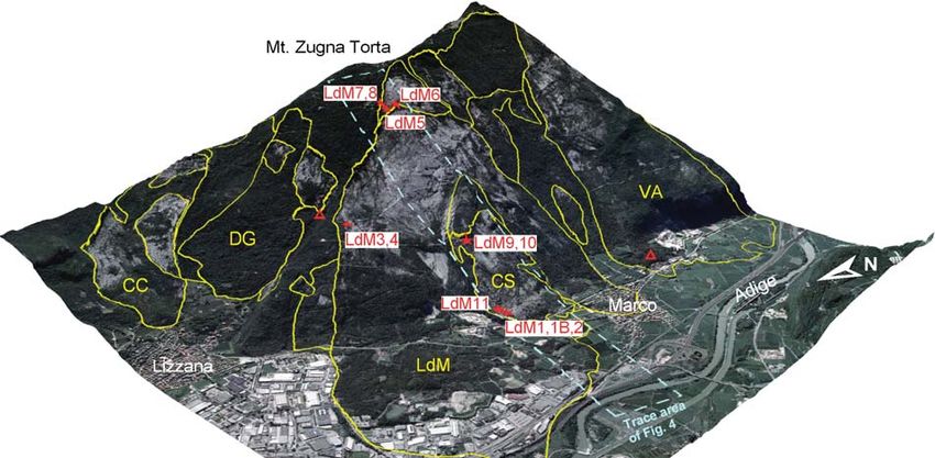
192                                                                                                                        Martin S. et al.

Fig. 1 - Simplified geological map of the Sarca and Adige Valleys (data from the Geological Survey of Trento, CARG project database).
Circle size is proportional to landslide volume (modified from Ivy Ochs et al., 2017b; Elsevier used with permission). The Tovel deposits,
with an estimated total volume of 300 Mm3 (Oetheimer, 1989) and shown as a single circle, are due to multiple events. The names of the
landslides studied in this work are in red.

Aaron & Hungr, 2016).                                                     2. LANDSLIDES OF THE WESTERN DOLOMITES
      Here we present four landslide cases in the west-
ern Dolomites (Trentino & South Tyrol). Lavini di Marco                         The map of Figure 1 shows the distribution of the
and Termeno are in the Adige Valley, while Marocche di                    largest landslide deposits of the western Dolomites. The
Dro and Molveno are located between Lake Garda and                        Adige Valley includes, among others, the Lavini di Marco
the Brenta Dolomites. The aim is to reexamine and dis-                    (200 Mm3; Martin et al., 2014), Castelpietra (6 Mm3; Ivy-
cuss some data from literature, regarding the rock ava-                   Ochs et al., 2017a) and Termeno (related to several
lanches of this region, and to present original data on                   rockfall events) landslide deposits. The adjacent Sarca
the Termeno rockfall study. The landslides discussed in                   Valley and the Brenta Dolomites include the Marocche di
this paper have been also presented in the framework of                   Dro (>1300 Mm3; Ivy-Ochs et al., 2017b), Molveno (600
the sites visited in Trentino/South Tyrol during the Sum-                 Mm3; von Wartburg et al., 2020) and Tovel (related to
mer School on “Historic and prehistoric landslides in the                 several landslide events with total volume of 300 Mm3;
NE Italian Alps - Implications for new hazard maps in                     Oetheimer, 1989) rock avalanche deposits.
mountainous areas”, hosted by the University of Padua                           The famous Lavini di Marco rock avalanche deposit
in 2019. The other sites of the Veneto region visited                     is located near Rovereto, in the middle reach of the Adi-
during the summer school are presented in a compan-                       ge Valley. It was mentioned by Dante Alighieri in the
ion paper of this volume (Rossato et al., 2020b).                         Divina Commedia (Alighieri, 1314) and was also studied
Landslides of the western Dolomites                                                                                                193

Fig. 2 - Landslide scarps and deposits along the western slope of Mt. Zugna Torta (from Martin et al. 2014; Elsevier used with permission).
Stars mark the 36Cl dated samples for Lavini di Marco (LdM) and Costa Stenda (CS). Red triangles mark sites of 14C-dated samples
(Orombelli & Sauro, 1988) (cf. Fig. 5).

by many naturalists in the XIX century (Noriller, 1871;                   were much more recent, as shown by isotopic dating,
Penck, 1886). The Termeno landslide is an historical                      historical records and updated geomorphological obser-
event, located a few kilometers south of Bolzano, on the                  vations (Martin et al., 2014; Carton, 2017; Ivy-Ochs et
right side of the Adige River. It is characterized by isolat-             al., 2017b; Rossato et al., 2020a; von Wartburg et al.,
ed gigantic boulders (up to hundreds of cubic meters in                   2020).
volume) detached from the rock walls overhanging the
Gewürztraminer vineyards. Between Lake Garda and                          3. ROCK AVALANCHES AND ROCKFALLS OF THE
the Brenta Dolomites, the Marocche di Dro and Molveno                     ADIGE VALLEY
rock avalanche deposits are located within the Southern
Giudicarie tectonic realm and have been studied for                       3.1 Lavini di Marco
more than one century (Lepsius, 1878; Damian, 1890;                             The Lavini di Marco rock avalanche deposits con-
Trener, 1924; Abele, 1974; Perna, 1974; 1975).                            sist of the main Lavini di Marco (LdM in Fig. 2) and the
      These rock failures are located close to the seismi-                minor Costa Stenda deposits (CS in Fig. 2), separated
cally active faults of the NNE-trending Southern Giudi-                   by the Costa Stenda ridge. Other deposits are located
carie and the NW-trending Schio-Vicenza fault systems,                    on the same flank of the Mt. Zugna Torta (CC, DG, VA in
or at the junction of them (Castellarin et al., 2005;                     Fig. 2). These two principal deposits cover a total area of
Viganò et al., 2015; 2018). The asymmetric valley con-                    4.2 km2, with a length of about 4.8 km and a width of
figuration is generally characterized by west-dipping                     about 1.8 km, yielding an estimated volume of 200 Mm3
bedding planes on eastern valley slopes and tectonic                      (Martin et al., 2014). Deposits are located between the
scarps on the western ones. These are due to the re-                      Adige plain (at 170 m a.s.l.) and the head scarp (at 1260
gional setting of the Giudicarie fault system, which is                   m a.s.l.; Fig. 3). Based on an estimated run-out distance
also responsible of the NNE-trending synclines hosting                    of ~4.8 km, Abele (1974) calculated a fahrböschung
Lake Garda, the Sarca Valley and the Molveno lake.                        angle of 12°. The rock avalanche involved Jurassic car-
The Lavini di Marco, Marocche di Dro and Molveno rock                     bonate rocks of the Calcari Grigi Group, including the
avalanches, as others in the Alpine region, were previ-                   Monte Zugna, Loppio and Rotzo Formations (see strati-
ously ascribed to stress release following downwasting                    graphic column in Fig. 4). Detachment occurred on dip-
of glaciers at the end of the Last Glacial Maximum, and                   slope bedding planes, cut across by NW-trending faults
were thought to have occurred between 18,000 and                          belonging to the Schio-Vicenza system which (Fig. 4).
12,000 years ago. However, these rock avalanches                                Combination of field survey, remote imagery analy-
194                                                                                                                       Martin S. et al.

Fig. 3 - The sliding surface and the 30 m-high head scarp of Lavini di Marco (photo by G. Griesmeier, 2019). The site is located near the
LdM5 sampling site (cf. Fig. 2).

Fig. 4 - Schematic geological section of the Lavini di Marco and Costa Stenda rock avalanche deposits. Samples collected along the sec-
tion are also shown (from Martin et al., 2014; Elsevier used with permission).
Landslides of the western Dolomites                                                                                                195

Fig. 5 - Distribution of 36Cl exposure ages (stars) for the Lavini di Marco and Costa Stenda rock avalanche deposits (sample number: age ±
uncertainty) (from Martin et al., 2014; Elsevier used with permission). Radiocarbon sites and calibrated 14C ages (triangles) from Orombelli
& Sauro (1988) (cf. Fig. 2).

sis, and 36Cl surface exposure dating allowed to inter-                    Torta slope since the 1990s (Tommasi et al., 2009).
pret the Lavini di Marco deposits (Martin et al., 2014).                   Before monitoring started, deformations were believed
The main release scarp extends from the town of Marco                      to be no longer active. This conviction having been
up to Mt. Zugna Torta, structurally controlled by the                      strengthened by the high safety factors provided by limit
Lizzana-Vallone fault (Fig. 4). Clear bedding planes                       equilibrium analyses (Tommasi et al., 2009). SAR satel-
(about 20° to NW) acted as sliding planes (Fig. 4). Upon                   lite interferometry performed in the period 1990-2002
release, the Lavini di Marco debris spread out on the                      and probe inclinometer measures showed a very slow
Adige River flood plain and accumulated deposits with a                    sliding of the slabs located uphill of the buckle folds. To
marked concentric outer ridge made of Monte Zugna                          strengthen this observation, buckling was back-
limestone, pushing the Adige River to the western side                     analyzed using Distinct Element Method (DEM) and
of the valley (Fig. 2).                                                    Discontinuous Deformation Analysis (DDA), and deter-
      The ages obtained by dating the Lavini di Marco                      mining rock mass structure, strength and stiffness by
and Costa Stenda boulders cluster around 3,000 years                       extensive in-situ (core logging, geophysical surveys)
before present (Fig. 5). The two failures occurred almost                  and laboratory investigations (geotechnical tests). The
simultaneously, giving a final age of 3.0 ±0.4 ka (Martin                  studies confirmed that buckling deformations are defi-
et al., 2014). Cosmogenic 36Cl data show later failures                    nitely possible, in the presence of water pressure and
at the head scarp during the Middle Ages (0.8 ±0.2 ka;                     minor flexures, suggesting that buckling deformation
samples 7 and 8 in Fig. 5). Published radiocarbon ages                     may evolve into failures and should therefore be consid-
give a middle Holocene age for the Dosso Gardene                           ered in evaluating the long term slope stability.
landslide (Orombelli & Sauro, 1988; DG in Fig. 5). More-
over, radiocarbon ages for the Varini landslide event are                  3.2 Termeno
broadly coincident with the younger ages of Lavini di                            The Termeno case study shows an example of
Marco (Orombelli & Sauro, 1988; VA in Fig. 5). These                       monitoring a steep scarp with big boulders rockfall. The
events seem to overlap in time with a catastrophic flood                   site affected by the landslide (Freisinger Hof) is located
event of the Adige River in Verona in 883 AD.                              between Cortaccia and Termeno along the right slope of
      In the lower part of the Lavini di Marco sliding sur-                the Adige Valley (Fig. 1). Here, the mountain slope rises
face, strata are buckle folded due to gravity (Martin et                   from the valley bottom (214 m a.s.l.) up to the Mendola
al., 2014), pushing to a monitoring of the Monte Zugna                     ridge (1800-2100 m a.s.l.). The bedrock is composed of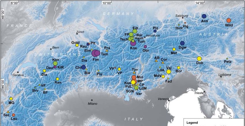
196
                                                                                                                           Martin S. et al.

Fig. 6 - A) The rockfall in Termeno (Freisinger Hof), occurred on 21st January 2014. B) The niche composed of Contrin limestone, with
remnants of hanging rocks before blasting. C) Final position of a huge boulder, very close to the house. D) Freisinger Hof and the deep
grooves made by rockfall boulders.

carbonate rocks and clastic sediments belonging to                      rockfall area were performed. Special attention was
Permo-Triassic sequences (Avanzini et al., 2012). Uphill                paid to map trajectories of the blocks ejected during
of Cortaccia-Termeno there is a 100 m-high vertical                     blasting (Fig. 7). These observations were used for a
steep wall (Fig. 6). Here, the dolomitized limestone of                 detailed back analysis, testing, and calibrating different
the Contrin Formation shows almost horizontal bedding,                  rockfall simulations (Fig. 8). Notably, there was a good
which is cut across by pervasive orthogonal fractures.                  agreement between observations and numerical results,
At their base, the presence of silty and clayey metape-                 not only on the trajectories, but also on the jump dis-
lites of the Giovo Formation is responsible for the for-                tances and heights, on the impact locations, and on the
mation of large carbonate towers and pinnacles over                     final position of the blocks. Thus, we can rely on the
the clay layer. This configuration, reported also for other             accuracy of this reconstruction of the 21st January 2014
nearby sectors along the Adige Valley right side                        event. As a final step, the entire slope was mapped in
(Avanzini et al., 2012), is responsible for systematically              detail, considering all the necessary parameters to carry
falling down cubic rock bodies and, in some cases, for                  out simulations and to adequately plan protection struc-
toppling rock towers (several meters in diameter, vol-                  tures.
ume up to 400 m³). For this reason, this area is one of                       A detailed historical analysis has been carried out
the best examples to reconstruct and understand these                   in the archives of the Benedictine Order of Freising in
types of processes.                                                     Bavaria, which owns the farm. The buildings in the area
      One of these events, which occurred on 21st Janu-                 date back to 1661 AD and provided detailed records of
ary 2014 (at hour 23:56), is well documented by the                     the agricultural activities performed since their construc-
Geological Survey of South Tyrol (Fig. 6). The area,                    tion. In these archives there is no mention of any
evacuated during the night, was later examined by heli-                 rockfall that reached the buildings or the vineyards, but
copter and photographically documented, to plan all the                 at least one huge block rolled down to this place along a
security measures. Then, yard and power poles were                      trajectory analogous to those of the 21st January 2014
protected by artificial walls, and the remaining portion of             event (Fig. 7B). It is probable that the impact of this
the rock tower was blasted. At the same time, a detailed                event on the buildings or the vineyards would have reg-
orthophoto map and a digital elevation model of the                     istered in the financial records of the farm. Henceforth,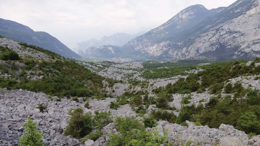
197
Landslides of the western Dolomites
Fig. 7 - A) Boulder trajectories of the Termeno rockfall. B) A huge boulder located near Freisinger Hof since before 1661 AD (location in A,
red circle).
we can empirically estimate that the returning period for
this event could be about 400 years. ries, explaining the lack of towns in the valley as testi-
fied by historical records.
4. ROCK AVALANCHES OF THE SARCA VALLEY Kas deposits show a barren, stark landscape
made up of house-sized Rotzo boulders, stacked in an
4.1 Marocche di Dro open framework deposit (Fig. 10). 36Cl data show that
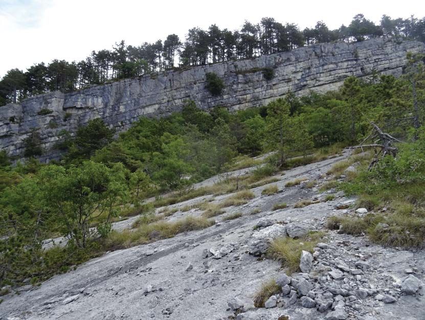
The Marocche di Dro include some of the most rock failure (about 300 Mm3) from the Mt. Brento east-
impressive rock avalanche deposits in the Alps (Figs. 9, ern face occurred 1.1±0.2 ka ago (single ages in Fig. 9).
10). Earlier authors discussed as many as twelve differ- It should be noted that, within the Kas deposits, 5-10 m-
ent landslides, including five grouped as Marocche di high longitudinal flow ridges extend radially, outward
Dro (e.g., Trener, 1924). Based on fieldwork, remote from the release area below Mt. Brento (Fig. 11B). Dur-
imagery analysis and 36Cl surface exposure dating, Ivy- ing the Kas event the southern portion of the Marocca
Ochs et al. (2017b) delimited the two main deposits, Principale deposits was buried. The finding of roof tile
namely the Marocca Principale and the overlying Kas fragments (probably Roman in age; Trener, 1924) be-
(Figs. 9, 11). The largest Marocca Principale event, tween the two rock avalanche deposits suggests the
when about 1000 Mm3 of predominantly Rotzo lime- presence of some “Kasae” (rustica villae) in the valley.
stones collapsed, occurred 5.3±0.9 ka ago. The release Nevertheless, reference to this event cannot be found in
area extends along the vertical wall from Mt. Casale to any historical document. For both Marocca Principale
Mt. Granzoline, likely also including Mt. Brento (Fig. 9). and Kas, an initial translational failure likely quickly
The Marocca Principale blocked the Sarca River form- evolved to massive collapse and complex failure, fol-
ing a dam; tens of meters of fluvial and lacustrine sedi- lowed by a run-out across the valley and a run-up on the
ments accumulated upstream, forming the Sarche plain eastern slope.
sediments (Fig. 11). On the southern side, the Marocca Several factors contribute to the prevalence of rock
Principale deposits were covered by the younger Kas slope failures along this reach of the Sarca Valley. First,
event. However, the interpretation of core drilling and the extreme relief of more than one kilometer along the
geophysical data suggest that further blocky deposits Mt. Casale-Mt. Brento wall. This is attributable to Mio-
are lying buried beneath the plain (Ivy-Ochs et al., cene downcutting, amplified by undercutting by the Adi-
2017b). The Sarca plain remained swampy over centu- ge glacier during the Quaternary (Ivy-Ochs et al., 2017b
Fig. 8 - Simulation of failures with the planned dam. Left - jump height. Right: reach probability.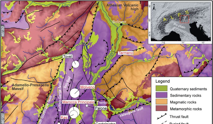
198 Martin S. et al.
Landslides of the western Dolomites                                                                                              199

Fig. 10 - The Kas blocky deposit, looking southward. Boulders in foreground are several meters in diameter.

and references therein). Second, tectonics play a deci-                   1951 (and again recently in spring 2017), the lake was
sive role in the repeated failures. In fact, fractures and                drained and standing tree trunks of a drowned forest
faults reduce rock mass strength. The lower Sarca Val-                    buried by delta deposits were discovered.
ley is dominated by the NNE-SSW oriented, ESE-to-SE                             Detailed geomorphological mapping, cosmogenic
                                                                          36
verging Giudicarie fold-and-thrust belt. Moreover, NW-                      Cl exposure dating and numerical run-out modelling
SE oriented nearly vertical strike-slip faults, belonging to              were used to reconstruct the Molveno rock avalanche
the Schio-Vicenza system, cut across the Giudicarie                       (von Wartburg et al., 2020). Due to the complicated mor-
faults dislocating originally adjacent structural blocks (cf.             phology of the landslide deposits (e.g., the elevated Pian
Fig. 1). Post-compressional reactivation of N-S oriented                  delle Gaorne plain in Fig. 12), with evidence of internal
Mesozoic normal faults and fractures facilitated backwall                 collapses (secondary scarps within the deposit; Fig. 13),
detachment.                                                               the reconstruction of the source location and dynamics
                                                                          of the landslide remain a challenging issue. Reflecting
4.2 Molveno                                                               as well this complicated setting, some authors suggest-
      The Molveno rock avalanche, with a volume of                        ed that the deposits were produced by several events
about 600 Mm3, is probably the largest single-event rock                  coming from different source areas on both sides of the
avalanche in the Brenta Dolomites and one of the larg-                    valley, Mt. Gazza to the east and Mt. Soran to the west
est in the Alps. As shown on Figure 12, rock avalanche                    (Lepsius, 1878; Fuganti, 1969; Chinaglia, 1992): Con-
deposits dammed the valley to the north forming (or                       versely, other authors described the deposits as one
raising the level of) the lake of Molveno (823 m a.s.l.)                  large event coming from a prominent niche on Mt. Soran
(Chinaglia & Fornero, 1995; Sauro & Zampieri, 2001). In                   (Damian, 1890; Schwinner, 1912).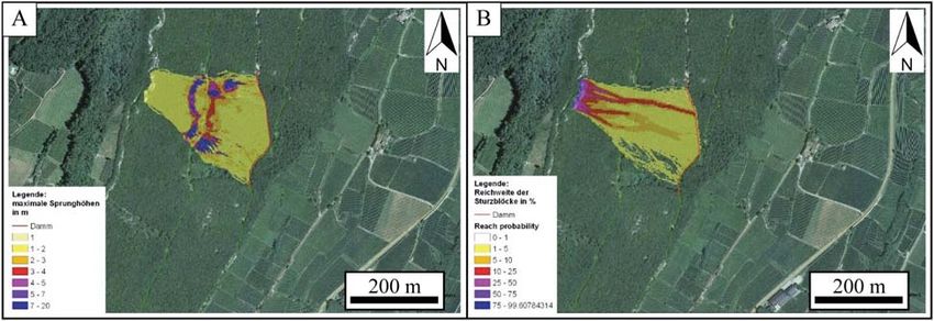
200                                                                                                                    Martin S. et al.

Fig. 11 - Geomorphology of the Marocche di Dro deposits. A) Slope map. B) Aspect map. C) Detailed sketch of the Dro and Ceniga plains,
where visible toma likely belong to the Marocca Principale deposits (from Ivy Ochs et al., 2017b; Elsevier used with permission).
Landslides of the western Dolomites                        201

       von Wartburg et al. (2020) obtained a mean age of
4.8±0.5 ka, based on cosmogenic 36Cl surface exposure
dating of boulders across the deposits (Fig. 12). This
indicates emplacement as a single huge landslide at
Molveno. For this reason, the secondary collapses visi-
ble within the deposit (cf. Fig. 13) likely occurred
(closely) after this main event. Among all the studied
boulders of Molveno, only the two dated ones from
Nembia gave ages that are about 2000 years younger
(2.1±0.3 and 2.4±0.2 ka; Fig. 12). It is most likely be-
cause them were covered by water until 2000 years ago
(von Wartburg et al., 2020).
       To simulate the Molveno landslide and to test the
reliability about only one event from Mt. Soran, a numer-
ical run-out model was performed, assuming a pre-
failure topography (Dan3D-Flex code; Hungr, 1995;
McDougall & Hungr, 2004; Aaron & Hungr, 2016). The
basic software (Dan3D) is designed to simulate ex-
tremely rapid, flow-like, mass movements (McDougall &
Hungr, 2004), while its add-in (Flex) allows to model
initially partially coherent landslides with planar sliding
followed by rapid fragmentation (Aaron & Hungr, 2016).
The modelling results are shown in Figure 14. They well
reproduce the extent of the mapped landslide, despite
the predicted thickness locally show significant devia-
tions from observations, such as at Pian delle Gaorne
(von Wartburg et al., 2020).
-----                                            ----->>>>>

Fig. 12 - Terrain map of the Molveno rock avalanche deposits,
with geographical names and 36Cl sampling sites and ages
(from von Wartburg et al., 2020).

Fig. 13 - Slope (on the left) and aspect maps (on the right) for
the Molveno deposits (from von Wartburg et al., 2020).
202 Martin S. et al.
5. DISCUSSION
During the last decades, several
authors have examined spatial and tem-
poral patterns of catastrophic rock slope
failures with the aim of understanding
predisposing factors and triggering
mechanisms, both in the Dolomites
(Fuganti, 1969; Abele, 1974; Perna,
1996; Borgatti et al., 2006; Borgatti &
Soldati, 2010; Martin et al., 2014; Ivy-
Ochs et al., 2017a; 2017b; von Wartburg
et al., 2020) and generally in the Alps
(Soldati et al., 2006; Prager et al., 2008;
Zerathe et al., 2014; Ivy-Ochs et al.,
2017a; Singeisen et al., 2020). Three
periods of enhanced slope activity have
been discussed: 10-9 ka, 5-3 ka, and 2-
1 ka, the latter especially for the South-
ern Alps. A summary of all the large (>1
Mm3) dated landslides in the Alps is
shown in Figure 15.
5.1 Bedrock structure and tectonics
The rock avalanches and land-
slides described herein have clear simi-
larities regarding lithology and structural Fig. 14 - Time series of the run-out model for the Molveno rock-avalanche. The extent
setting, as they belong to the same tec- of the observed deposit is well reproduced (from von Wartburg et al., 2020).
tonic domain: the western Trentino crus-
tal block (Viganò et al., 2015). The Lavini di Marco, numerous faults and fractures associated with these
Marocche di Dro and Molveno rock avalanches are major tectonic systems exert strong control on vertical
developed in Jurassic limestones, specifically Rotzo, detachment surfaces (i.e. back walls and side walls), as
Loppio and Tofino Formations, which are characterized discussed above for the NNW-trending Lizzana-Vallone
by the presence of cm-dm thick clay intercalations that fault at Lavini di Marco and the NW-oriented steep side
can facilitate sliding. Numerous rock slope failures are wall in the Molveno release area (cf. Figs. 4, 12). Final-
concentrated in this distinctive area which is con- ly, in these mountainous areas, rock damage and asso-
strained between two large, deeply rooted rigid do- ciated fatigue and reduction in strength due to past tec-
mains: the Athesian Volcanic high (Bargossi et al., tonics (Brideau et al., 2009) and recent active defor-
1998) to the northeast and the Adamello intrusions to mation pose the question of the present and future haz-
the west (Fig. 1). Between these two domains, late Al- ards of these inhabited Alpine valleys.
pine deformation, due to counterclockwise motion of
Adria, predominantly along the Schio-Vicenza fault with 5.2 Landslide timing and driving forces
shortening of the western Trentino block, was strongly Very few events in the Alps have been dated to
constrained within the Giudicarie belt. Most of the defor- the Lateglacial (18-12 ka). Therefore, the concept that
mation was concentrated along the Southern Giudicarie the huge landslides in Trentino, or the Alps overall, oc-
master fault bordering the Adamello but also along mi- curred during the early Lateglacial directly following ice
nor faults of this system. Accordingly, the landslide de- retreat, implicating debuttressing as a driving force, can
posits studied here are concentrated along faults that now be discounted based on the numerous ages pre-
belong to the NNE-trending Southern Giudicarie and to sented in Figure 15. Even for two of the oldest dated
the NW-trending Schio-Vicenza fault systems, or lay at landslides in the Alps (Flims, Koefels), it is important to
the junction of those two systems (Castellarin et al., note that glaciers had not occupied those valleys for
2005). Along the Giudicarie, asymmetric folds at the many thousand years prior to the catastrophic events
kilometer scale also occur. These generate a geological (Ivy-Ochs, 2015). Two of the largest events in the Alps,
setting dominated by west-dipping monoclinic surfaces Flims (10-12 km3) and Koefels (3 km3), have been dat-
and east-facing tectonic scarps. The associated syn- ed to the period 10 to 9 ka ago (Ivy-Ochs et al., 2017b
clines host respectively Lake Garda, Sarca Valley and and references therein). Early Holocene rock slope
the Molveno lake. Within this framework, rock masses failure events may be related to marked warming at
detached along the dip slope bedding planes associat- 10.5-10.0 ka that forced retreat of glaciers to positions
ed with clay-rich interbeds on the west-facing slopes, as perhaps even smaller than today’s and was likely ac-
for example at Lavini di Marco. On the east-facing companied by rapid permafrost degradation at higher
slopes of the Sarca Valley, toppling and massive col- elevations. However, a seismic trigger has been recent-
lapse are the dominant processes (Perna, 1974; 1996), ly suggested for some coeval early Holocene landslides
such as the Marocca Principale rock avalanche. The in the Kander region (Grämiger et al., 2016). RecentLandslides of the western Dolomites 203
Fig. 15 - Compilation of isotopically dated and historical large (>1 Mm3) landslides in the Alps (modified and updated from Ivy-Ochs et al.,
2017b; Elsevier used with permission). Updates include the late Holocene Kandersteg (Kan), the middle Holocene Molveno (Mol), the late
Holocene Masiere di Vedana (MdV) (Rossato et al., 2020a) and the Tovel (Tov) events. Alm Almtal; Plz Pletzachkogel; Chi Chironico; Dgw
Durchgangwald; Rau Rautispitz; Dau Daubensee; KlR Klein Rinderhorn; Koe Koefels; Tam Tamins; Flm Flims; Obr Obernberg; VV Val
Viola; Vig Vigaun; Wild Wildalpen; Plt Platten; MP Marocca Principale; Lau Lauvitel; FP Fernpass; Eib Eibse; Bar Barwies; Tum Tumpen;
Hint Hintersee; Kan Kandersteg; Brv Brenva; LdM Lavini di Marco; Tsch Tschirgant; Mol Molveno; Haim Haiming; Petz Petzer Oberloibach;
Mat Matrei; MdV Masiere di Vedana; Fad Fadalto; Var Varini; Kas; CP Castelpietra; PDL Prà da Lago; MG Mont Granier; Dob Dobratsch;
SGN San Giovanni Nago; Bia Biasca; BF Becca France; Dis Disentis; Plu Plurs; Bor Borta; Dia Diableret; VF Val Ferret; LdA Lago di Alle-
ghe; Gold Goldau; Elm; Vaj Vajont; VP Val Pola; Ran Randa; Clp La Clapiere; Pra Prättigau; AB Alta Badia; Cor Cortina; SWA southwest-
ern Alps; Sec Sechiellene; Tov Tovel.
36
Cl dating of the Kandersteg deposits (location shown sive deposit was dated to 3.0 ±0.4 ka with 36Cl (Martin et
in Fig. 15) has revealed that this huge event (1.1 km3) al., 2014). Both Molveno, 4.8 ±0.5 ka (von Wartburg et
occurred 3.2 ±0.2 ka ago (Singeisen et al., 2020) and al., 2020), and Marocca Principale, 5.3 ±0.9 ka, fall as
not 9.6 ka ago as previously proposed. This significantly well within the discussed time interval. Zerathe et al.
weakens the concept of an early Holocene cluster of (2014) point out that different proxies in the Alps sug-
major events. No failure events in the lower Sarca or gest a “4.2 ka” wet climatic event with associated en-
Adige valleys have yet been dated to the Lateglacial or hanced rock slope failure activity. Similarly, periods of
early Holocene. Nevertheless, in both valleys, the pres- climate degradation characterized by more frequent
ence of landslide deposits buried beneath alluvial fill flooding episodes and extreme meteorological events
cannot be ruled out, especially when one considers to have been recorded in the same timeframe (Wirth et al.,
the huge volume of rock missing along the Mt. Brento- 2013; Benito et al., 2015; Rossato et al., 2015). Under
Mt. Casale mountain front (Ivy-Ochs et al., 2017b). such conditions, stress field changes in the rock due to
Numerous authors identify a period of increased the added mass of water as well as weakening of clay-
landslide activity between 5 and 3 ka in the Alps and rich interbeds may have led to catastrophic failure. This
specifically in the Dolomites (Panizza et al., 1996; Dap- agrees with the opinions of Soldati et al. (2004) and
ples et al., 2003; Prager et al., 2008; Borgatti & Soldati, Borgatti & Soldati (2010) for rock avalanches of the
2010; Zerathe et al., 2014). In the lower Sarca and Adi- eastern Dolomites. Nevertheless, several researchers
ge valleys and nearby regions, several mass wasting underline the importance of strong tectonic events as
events have been dated to this period (Perna, 1996; triggers for the middle Holocene rock avalanches
Baroni et al., 2014). At Lavini di Marco the most exten- (Ambrosi & Crosta, 2006; Prager et al., 2008). Indeed,204 Martin S. et al.
the notable overlap in the ages of the Molveno and Ma- ment; strike-slip faults focus lateral constraints for de-
rocca Principale events which lie no more than 10 km taching blocks. East-facing tectonic scarps promote
apart (Fig. 1), may implicate a common seismic trigger toppling and massive collapse, as for example at Ma-
(von Wartburg et al., 2020). rocche di Dro (Marocca Principale and Kas rock ava-
Recent landslide activity in the western Dolomites, lanches). During both events at Marocche, and at Mol-
especially over the last several thousand years, is sug- veno, complex failure was followed by run-out across
gested to be related to seismic activity (Borgatti & the valley and tens of meters of run-up on the opposite
Soldati, 2010; Ivy-Ochs et al., 2017a; 2017b). Numer- slope. Smaller rockfalls may occur due to similar tecton-
ous catastrophic landslides are reported for post- ic settings, as in the case of Termeno. Here, the volume
Roman times, albeit somewhat schematically (Heim, of the debris was smaller, and the mass propagated as
1932; Eisbacher & Clague, 1984; Abele, 1997 and ref- single blocks, rolling, and jumping.
erences therein). Sauro & Zampieri (2001) suggest a The ages of the discussed rock avalanches and
third temporal cluster in the Southern Alps around 1000 landslides of the Sarca and Adige Valleys mainly fall in
AD, which was strongly related to neotectonics. In the the period 5-3 ka ago. This period broadly coincides
presented data set, this would include, the Kas land- with that of increased frequency for failure events, at the
slide (Ivy-Ochs et al., 2017b), the youngest dated transition from the middle to the late Holocene, when a
events at Lavini di Marco (Martin et al., 2014), the Varini shift to a wetter, colder climate occurred. Nevertheless,
rockslide (Orombelli & Sauro, 1988) and the Castel- a seismic driving factor is suggested for the landslides
pietra landslide (Ivy-Ochs et al., 2017a). Lake Garda, of this area. Although the Verona earthquake (1117 AD)
the lower Sarca and Adige Valleys are characterized by may have had a greater impact regionally, we suggest
low-to-moderate magnitude seismicity (moment magni- the “Middle Adige Valley” (1046 AD) seismic sequence,
tudeLandslides of the western Dolomites 205
gnozza G., Schirilò L. (2014) - Thermomechanical agement. Geol. Survey Canada, 84/16, p. 229.
stress-strain numerical modelling of deglaciation Fuganti A. (1969) - Studio geologico di sei grandi frane
since the last glacial maximum in the Adamello nella regione Trentino-Alto Adige (Marco, Molveno,
group (Raethian Alps, Italy). Geomorphology, 226, Prà del Finocchio, Malgrè, Sasso Englar, Rasciera).
278-299. Mem. Mus. Tr. Sci. Nat. 17, 5-69.
Basili R., Valensise G., Vannoli P., Burrato P., Fracassi Grämiger L.M., Moore J.R., Vockenhuber C., Aaron J.,
U., Mariano S., Tiberti M.M., Boschi E. (2008) - The Hajdas I., Ivy-Ochs S. (2016) - Two early Holocene
Database of Individual Seismogenic Sources rock avalanches in the Bernese alps (Rinderhorn,
(DISS), version 3: Summarizing 20 years of re- Switzerland). Geomorphology, 268, 207-221
search on Italy's earthquake geology. Tectonophys- Guidoboni E., Comastri A. (2005) - Catalogue of earth-
ics, 453, 20-43. quakes and tsunamis in the Mediterranean area
Doi: 10.1016/j.tecto.2007.04.014 from the 11th to the 15th century. Istituto Nazionale
Benito G., Macklin M.G., Panin A., Rossato S., Fontana di Geofisica e Vulcanologia, Storia Geofisica Ambi-
A., Jones A.F., Machado M.J., Matlakhova E., Mozzi ente, Bologna, Italy, pp.1037.
P., Zielhofer C. (2015) - Recurring flood distribution Guidoboni E., Ferrari, G., Mariotti D., Comastri A., Tara-
patterns related to short-term Holocene climatic busi G., Sgattoni G., Valensise G., (2018) -
variability. Scientific Reports, 5, 16398. CFTI5Med, Catalogo dei Forti Terremoti in Italia
Doi: 10.1038/srep16398 (461 a.C.-1997) e nell’area Mediterranea (760 a.C.-
Borgatti L., Ravazzi C., Donegana M., Corsini A., 1500). Istituto Nazionale di Geofisica e Vulcanologia
Marchetti M., Soldati M. (2006) - A lacustrine record (INGV).
of early Holocene watershed events and vegetation Doi: 10.6092/ingv.it-cfti5
history, Corvara in Badia, Dolomites. Italy. J. Qua- Heim A. (1932) - Bergsturz und Menschenleben. Viertel-
ternary Sci., 22 (2), 173-189. jahrschr. D. Naturf. Ges. Jg., Zürich, 77, pp. 218.
Borgatti L., Soldati M. (2010) - Landslides as a geomor- Hungr O. (1995) - A model for the runout analysis of
phological proxy for climate change: a record from rapid flow slides, debris flows, and avalanches. Ca-
the Dolomites (northern Italy). Geomorphology, 120, nadian Geotechnical Journal, 32, 610-623.
56-64. Hungr O., Leroueil S., Picarelli L. (2014). - The Varnes
Brideau M.A., Yan M., Stead D. (2009) - The role of classification of landslide types, an update. Land-
tectonic damage and brittle rock fracture in the de- slides, 11(2), 167-194.
velopment of large rock slope failures, Geomorphol- Ivy-Ochs S. (2015) - Glacier variations in the European
ogy, 103(1), 30-49. Alps at the end of the last glaciation. Cuad. Investig.
Doi: 10.1016/j.geomorph.2008.04.010 geografica 41, 295-315.
Carton A. (2017) - Large Ancient Landslides in Trentino, Ivy-Ochs S., Martin S., Campedel P., Hippe K.,
Northeastern Alps, as Evidence of Postglacial Dy- Vockenhuber C., Carugati G., Rigo M., Pasqual D.,
namics. In: M. Soldati & M. Marchetti (eds.), Land- Viganò A. (2017a) - Geomorphology and age of
scapes and Landforms of Italy. Springer Internation- large rock avalanches in Trentino (Italy): Castel-
al Publishing, Cham, 113-122. pietra. In: Mikoš M., Vilímek V., Yin Y., Sassa K.
Doi: 10.1007/978-3-319-26194-2_9 (Eds.) Advancing Culture of Living with Landslides.
Castellarin A., Picotti V., Cantelli L., Claps M., Trombet- WLF 2017. Springer, Cham, 347-353.
ta L., Selli L., Carton A., Borsato A., Daminato F., Ivy-Ochs S., Martin S., Campedel P., Hippe K., Alfimov
Nardin M., Santuliana E., Veronesi L., Bollettinari G. V., Vockenhuber C., Andreotti E., Carugati G.,
(2005) - Note illustrative della Carta Geologica d’Ita- Pasqual D., Rigo M., Viganò A. (2017b) - Geomor-
lia alla scala 1:50.000, Foglio n. 080, Riva del Gar- phology and age of the Marocche di Dro rock ava-
da, pp. 145. lanches (Trentino, Italy). Quat. Sci. Rev., 169, 188-
Chinaglia N. (1992) - Le "Marocche" Della Bassa Valle 205.
del Sarca: Scivolamenti Planari in unità calcaree Lepsius R. (1878) - Das westliche Südtirol: geologisch
stratificate. I Convegno nazionale dei Giovani Ricer- dargest. Hertz, pp. 375.
catori in Geologia Applicata, 47-56. Martin S., Campedel P., Ivy-Ochs S., Viganò A., Alfimov
Chinaglia N., Fornero E. (1995) - Ipotesi sulla possibile V., Vockenhuber C., Andreotti E., Carugati G.,
evoluzione cinematica di un movimento profondo di Pasqual D., Rigo M. (2014) - Lavini di Marco
versante: L'esempio del M. Soran (Trentino meridio- (Trentino, Italy): 36CI exposure dating of a polypha-
nale) Memorie della Società Geologica Italiana, 50, se rock avalanche. Quat. Geochron., 19, 106-116.
101-108. McDougall S., Hungr O. (2004) - A model for the analy-
Damian J. (1890) - Der Molvenosee in Tirol. A. Peter- sis of rapid landslide motion across three-
manns Mitteilungen aus Justus Perthes' Geographi- dimensional terrain. Canadian Geotechnical Journal,
scher Anstalt, 262-270. 41, 1084-1097.
Dapples F., Oswald D., Raetzo H., Lardelli T., Zwahlen Noriller G.B. (1871) - I Lavini di Marco. Rovereto, pp.
P. (2003) - New records of Holocene landslide activ- 237.
ity in the Western and Eastern Swiss Alps: implica- Oetheimer C. (1989) - Etude géomorphologique des
tion of climate and vegetation changes. Eclogae éboulements remaniés de la Vallée de Tovel: contri-
Geol. Helv., 96, 1-9. bution à la connaissance des «marocche» du Tren-
Eisbacher G.H., Clague J.J. (1984) - Destructive mass tin (Italie). Studi trentini di scienze naturali. Acta
movements in the high mountains: hazard and man- geologica, 65, 3-47.206 Martin S. et al. Orombelli G., Sauro U. (1988) - I Lavini di Marco: un Journal of Earth Sciences, 5, 127-197. gruppo di frane oloceniche nel contesto morfotetto- Singeisen C., Ivy-Ochs S., Wolter A., Steinemann O., nico dell’alta val Lagarina (Trentino). Suppl. Geogr. Akçar N., Yesilyurt S., Vockenhuber C. (2020) - The Fis., Dinam. Quater., 1, 107-116. Kandersteg rock avalanche (Switzerland): integrat- Panizza M., Pasuto A., Silvano S., Soldati M. (1996) - ed analysis of a late Holocene catastrophic event. Temporal occurrence and activity of landslides in Landslides, 17, 1297-1317. the area of Cortina d’Ampezzo (Dolomites, Italy). Soldati M., Corsini A., Pasuto A. (2004) - Landslides Geomorphology, 15, 311-326. and climate change in the Italian Dolomites since Penck A. (1886) - Die “Slavini di S. Marco”. Die Alpen the Late glacial. Catena 55, 141-161. im Eiszeitalter. C.H. Tauchnitz Leipzig, 3, pp. 1200. Soldati M., Borgatti L., Cavallin A., De Amicis M., Penck A., Brückner E. (1909) - Die Alpen im Eiszeital- Frigerio S., Giardino M., Mortara G., Pellegrini G.B., ter. Dritter band. Die Eiszeiten in den Sudalpen und Ravazzi C., Surian N., Tellini C., Zanchi A., in col- im Bereich der Ostabdachung der Alpen. Ed. laboration with Alberto W., Albanese D., Chelli A., Tauchnitz, Lipsia, pp. 1199. Corsini A., Marchetti M., Palomba M., Panizza M. Perna G. (1974) - Le frane glaciali e postglaciali nel (2006) - Geomorphological evolution of slopes and Trentino meridionale (“Marocche” e “Laste”). Boll. climate changes in northern Italy during the Late Com. Glaciol. It., 22, 59-66. Quaternary: spatial and temporal distribution of Perna G. (1975) - Laste e Marocche nel Basso Trenti- landslides and landscape sensitivity implications. no. Economia Trentina 4, 37-44, Trento. Geogr. Fis. Dinam. Quat., 29(2), 165-183. Perna G. (1996) - Itinerari geologici: Inquadramento Taramelli T. (1881) - Di alcuni scoscendimenti postgla- cronologico delle grandi frane quaternarie delle Valli ciali sulle Alpi meridionali. Rendiconti del Reale dei Laghi e del Basso Sarca (Trentino) Economia Istituto Lombardo, s. 11, p. XIV, 111, pp. 7. Trentina, 3, 55-89 (Trento). Tommasi P., Verrucci L., Campedel P., Veronese L., Perna G., Sauro U. (1978) - Atlante delle microforme di Pettinelli E., Ribacchi R. (2009) - Buckling of high dissoluzione carsica superficiale del Trentino e del slopes: the case of Lavini di Marco (Trento-Italy). Veneto. Mem. Mus. Trident. Sci. Nat. 22, 1-176. Engineering Geology, 109 (1-2), 93-108. Prager C., Zangerl C., Patzelt G., Brandner R. (2008) - Doi: 10.1016/j.enggeo.2009.02.002 Age distribution of fossil landslides in the Tyrol Trener G.B. (1924) - Gli impianti idroelettrici della città (Austria) and its surrounding areas. Nat. Hazards di Trento, II. Geologia delle Marocche, 25-33 con Earth Syst. Sci., 8, 377-407. carta geologica 1:25.000 Studi Trentini Sci. Nat., 34 Rossato S., Fontana A., Mozzi P. (2015) - Meta- (2), 319-340. analysis of a Holocene 14C database for the detec- Viganò A., Scafidi D., Martin S., Spallarossa D. (2013) - tion of paleohydrological crisis in the Venetian- Structure and properties of the Adriatic crust in the Friulian Plain (NE Italy). Catena, 130, 34-45. central-eastern Southern Alps (Italy) from local Doi: 10.1016/j.catena.2014.10.033 earthquake tomography. Terra Nova, 25, 504-512. Rossato S., Ivy-Ochs S., Martin S., Viganò A., Viganò A., Scafidi D., Ranalli G., Martin S., Della Vockenhuber C., Rigo M., Monegato G., De Zorzi Vedova B., Spallarossa D. (2015) - Earthquake M., Surian N., Campedel P., Mozzi P. (2020a) - relocations, crustal rheology, and active deformation Structural and climate drivers of the historic Masiere in the central-eastern Alps (N Italy). Tectonophysics, di Vedana rock avalanche (Belluno Dolomites, NE 661, 81-98. Italy), Natural Hazards and Earth System Sciences, Viganò A., Zampieri D., Rossato S., Martin S., Selli L., 20,2157-2174. Prosser G., Ivy-Ochs S., Campedel P., Fedrizzi F., Doi: 10.5194/nhess-2019-413 Franceschi M., Rigo M. (2018) - Past to present Rossato S., Ghirotti M., Gabrieli F., Livio F., Bovo F., deformation of the central-eastern Southern Alps: Brezzi L., Campedel P., Cola S., Ivy-Ochs S., Martin from the foreland to the Giudicarie belt. In: Geologi- S., Mozzi P., Pasuto A., Rigo M., Simonini P., cal field trips and maps 2018. Periodico semestrale Surian N., Viganò A., Vockenhuber C., Wolter A. del Servizio Geologico d’Italia - ISPRA e della Soci- (2020b) - Learning from the past to face the future: età Geologica Italiana 10(1.1) pp. 78. landslides in the Piave Valley (Eastern Alps, Italy). Doi: 10.3301/GFT.2018.01 Alpine and Mediterranean Quaternary, 33, 2, 209- von Wartburg J., Ivy-Ochs S., Aaron J., Martin S., Leith 228. K., Rigo M., Vockenhuber C., Campedel P., Viganò Doi:10.26382/AMQ.2020.14 A. (2020) - Constraining the age and source area of Rovida A., Locati M., Camassi R., Lolli B., Gasperini P. the Molveno landslide deposits in the Brenta Group, (2019) - CPTI15, the 2.0 Version of the Parametric Trentino Dolomites (Italy). Frontiers in Earth Scienc- Catalogue of Italian Earthquakes. Istituto Nazionale es, 8, 164. di Geofisica e Vulcanologia, Italy. Doi: 10.3389/feart.2020.00164 Doi: 10.13127/CPTI/CPTI15.2 Wirth S.B., Glur L., Gilli A., Anselmetti F.S. (2013) - Sauro U., Zampieri D. (2001) - Evidence of recent sur- Holocene flood frequency across the Central Alps - face faulting and surface rupture in the Fore-Alps of solar forcing and evidence for variations in North Veneto and Trentino (NE Italy). Geomorphology, 40, Atlantic atmospheric circulation. Quaternary Science 169-184. Reviews, 80, 112-128. Schwinner R. (1912) - Der Mte. Spinale bei Campiglio Doi: 10.1016/j.quascirev.2013.09.002 und andere Bergstürze in den Südalpen. Austrian Zerathe S., Lebourg T., Braucher R., Bourlès D. (2014)
Landslides of the western Dolomites                                                                                          207

- Mid-Holocene cluster of large-scale landslides
revealed in the Southwestern Alps by 36Cl dating.
Insight on an Alpine-scale landslide activity. Quater-
nary Science Reviews, 90, 106-127.
Doi: 10.1016/j.quascirev.2014.02.015

                                                         Ms. received: July 21, 2020   Revised: November 15, 2020
                                                         Accepted: December 7, 2020    Available online: December 20, 2020
208
You can also read