On the origin of the Strait of Gibraltar
←
→
Page content transcription
If your browser does not render page correctly, please read the page content below
Sedimentary Geology 188–189 (2006) 341 – 356
www.elsevier.com/locate/sedgeo
On the origin of the Strait of Gibraltar
Nicolas Loget ⁎, Jean Van Den Driessche
Géosciences Rennes, Université de Rennes 1, UMR 6118, Campus de Beaulieu, 35042 Rennes cedex, France
Abstract
Most interpretations of the Early Pliocene opening of the Strait of Gibraltar involve a tectonic process. However, no tectonic
structure of this age has been unequivocally documented that could account for such a hypothesis. On the other hand, the sea-level
drop of the Mediterranean during the Messinian Salinity Crisis has dramatically enhanced continental erosion and in particular
regressive fluvial erosion. We show that such erosional process inevitably developed in the Gibraltar area. We finally propose that
regressive fluvial erosion was at the origin of the opening of the Strait of Gibraltar.
© 2006 Elsevier B.V. All rights reserved.
Keywords: Strait of Gibraltar; Messinian sea-level drop; Fluvial erosion; Pliocene reflooding
1. Introduction al., 2003). This triggered the desiccation of the Mediter-
ranean, inducing the so-called Messinian Salinity Crisis
The Strait of Gibraltar is an E–W narrow neck, (MSC) (Hsü et al., 1973a).
58 km long with a mean depth of about 350 m. Its width The opening of the Strait of Gibraltar in the Early
ranges from 13 km to the east, to 43 km at the western Pliocene allowed restoring the water exchange between
entrance (Fig. 1). The strait ensures the only water the Atlantic and Mediterranean waters. Surprisingly, the
communication between the Atlantic and the Mediter- origin of this opening is not so much of a concern to the
ranean. This exchange is crucial for the Mediterranean geological community. Because the Strait of Gibraltar is
to compensate the negative hydrological balance with situated in a long-lived tectonic region, most works have
loss through evaporation exceeding the input of water considered that its opening was induced by the collapse
through runoff and precipitation. Nowadays, closing of of a narrow graben related either to regional extension or
the Strait of Gibraltar would trigger a complete desic- strike-slip faulting (pull-apart basin) (e.g. Hsü et al.,
cation of the Mediterranean in about 1000 years (Hsü et 1973b; Campillo et al., 1992; Kastens, 1992; Mal-
al., 1973a). donado et al., 1999; Hodell et al., 2001). But, to our
Before the opening of the Strait of Gibraltar, the knowledge, no major normal faults have been docu-
Atlantic and Mediterranean waters were connected mented on both sides of the Strait of Gibraltar to support
through the Betic and Rif gateways, which were pro- these interpretations.
gressively uplifted and finally closed during the Mio- On the other hand, the desiccation of the Mediterra-
cene (e.g. Weijermars, 1988; Benson et al., 1991; nean during the Messinian has induced a dramatic sea-
Krijgsman et al., 1999b; Martín et al., 2001; Duggen et level drop that has been estimated up to 1500 m below
the current sea-level (Hsü et al., 1973a; Clauzon et al.,
⁎ Corresponding author. 1996). A major consequence of this base-level drop was
E-mail address: nicolas.loget@univ-lr.fr (N. Loget). the strong re-incision of the rivers that were flowing into
0037-0738/$ - see front matter © 2006 Elsevier B.V. All rights reserved.
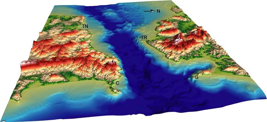
doi:10.1016/j.sedgeo.2006.03.012342 N. Loget, J. Van Den Driessche / Sedimentary Geology 188–189 (2006) 341–356 Fig. 1. Digital Elevation Model (view toward the west) of the Gibraltar Strait (land topography: SRTM90 DEM data; Gibraltar Strait bathymetry: isobaths from Giermann, 1961). The strait is 58 km long and narrows to 13 km in width between Point Marroquí, Spain, and Point Cires, Morocco. C: Ceuta; G: Gibraltar; TN: Tanger; TR: Tarifa. the Mediterranean, resulting in the cutting of deep can- MSC. We present a numerical modelling that shows yons by regressive erosion all around the Mediterranean how fluvial regressive erosion has developed in the region, including the Alboran Sea (e.g. Clauzon et al., Gibraltar area, following the scenario first proposed by 1996). Blanc (2002) proposed, by analysing the mor- Blanc (2002). The erosional parameters used in this phology of the Strait of Gibraltar, that regressive erosion modelling have been deduced from a previous study by an eastwards-flowing stream in the Gibraltar area was concerning erosion dynamics in the Messinian Rhone the main process by which the Strait of Gibraltar opened. valley (Loget et al., 2005) and are succinctly presented In the present paper we aim to show that there are no here. We finally discuss our results compared to tectonic structures that could account for the opening of previous interpretations. We conclude that the Strait of the strait by reviewing the previous works that were Gibraltar most probably originated in a Messinian pirate concerned with tectonics in the Gibraltar area and valley within which a stream flowing eastwards has surrounding regions. Then we discuss the consequences eventually captured the Atlantic waters, inducing their of the sea-level drop on erosion dynamics during the re-connection with the Mediterranean Sea. Fig. 2. Plate tectonics framework of the Gibraltar area (modified after Jiménez-Munt and Negredo, 2003). The Gibraltar area is part of the diffuse plate boundary between Africa and Eurasia. Note that no major fault zone follows the Strait of Gibraltar itself. GA: Gibraltar Arc; GoB: Gorringe Bank; BTf: Bato-Tajo fault; Nf: Nazare fault; PAf: Plasencia-Alentejo fault.
N. Loget, J. Van Den Driessche / Sedimentary Geology 188–189 (2006) 341–356                                 343

2. Which evidences for tectonically-driven                                 Comas et al., 1999; Platt et al., 2003; Frizon de Lamotte
reflooding through the Strait of Gibraltar?                                et al., 2004). (1) The external zone corresponds to the
                                                                           South Iberian and Maghrebian paleo-margins, formed of
2.1. Geological setting                                                    Mesozoic and Tertiary sediments. Crustal shortening
                                                                           was accompanied by the development of Iberian and
    The Strait of Gibraltar marks the limit between the                    African foreland basins (the Guadalquivir and Rharb
Atlantic and the westernmost Mediterranean, namely                         basins respectively). (2) The intermediate zone consists
the Alboran Sea, to the west and to the east respectively                  of the Flysch Nappes that are composed of Early
(Fig. 1). The Alboran Sea is bounded by the Betics to the                  Cretaceous to Early Miocene marine clastic deposits. (3)
north and the Morocco Rif to the south. They connect                       The internal zone is constituted by metamorphic base-
through the Gibraltar area, shaping an arcuate orogenic                    ment rocks that belong to the Alboran crustal domain,
belt, the so-called Gibraltar Arc (e.g. Michard et al., 2002).             and by Neogene intermontane basins.
Farther east, the Alboran Sea connects to the Balearic                         The history of the Gibraltar arcuate belt started during
basin and more generally to the Mediterranean basin.                       Late Oligocene–Early Miocene times when the Alboran
    The Gibraltar Arc results from the convergence                         domain was overthrusted onto the South Iberian and
between the African and European plates (Fig. 2) (e.g.                     Maghrebian continental margins (e.g. Comas et al.,
Dewey et al., 1989). This motion started during the                        1999). Further thrusting toward the west in the external
Upper Cretaceous and continued throughout the Ceno-                        zones led to the formation of the Gibraltar Arc during the
zoic. Lithospheric shortening generated a complex                          Middle Miocene and Late Miocene (e.g. Faccenna et al.,
pattern of Neogene thrust belts and extensional basins                     2004). Thrusting and crustal shortening in the external
throughout the Mediterranean (e.g. Lonergan and                            zone was contemporaneous with extension and crustal
White, 1997) (Fig. 3). The Gibraltar Arc is the western-                   thinning in the previously thickened, internal zone,
most end of a thrust belt extending from the Balearics up                  namely the Alboran domain (e.g. Platt and Vissers,
to the northern Apennines, through the Calabrian Arc to                    1989; García-Dueñas et al., 1992; Vissers et al., 1995;
the east (e.g. Tapponnier, 1977; Faccenna et al., 2004).                   Balanyá et al., 1997; Chalouan et al., 1997; Martínez-
    The Betic–Rif orogen is classically divided into three                 Martínez and Azañón, 1997; Comas et al., 1999; Platt et
structural zones (Fig. 4) that straddle the Strait of                      al., 2003). The relative motion between Africa and Iberia
Gibraltar (e.g. Wildi, 1983; Lonergan and White, 1997;                     involved about 200 km, N–S convergence from the

Fig. 3. Map of the Mediterranean region showing the Neogene extensional basins and the external front of the Alpine thrusts (after Lonergan and
White, 1997). AA — Aegean Arc; CA — Calabrian Arc; GA — Gibraltar Arc; A — Alps; AgS — Aegean Sea; AF — African Foreland; AlS —
Alboran Sea; Ap — Apennines; APB — Algerian Provencal basin; B — Betics; BS — Black Sea; GL — Gulf of Lion; IF — Iberian Foreland; LS —
Ligurian Sea; P — Pyrenees; PB — Pannonian basin; R — Rif; T — Tell; TS — Tyrrhenian Sea; VT — Valencia trough.
344 N. Loget, J. Van Den Driessche / Sedimentary Geology 188–189 (2006) 341–356 Fig. 4. Geological map of the Arc of Gibraltar showing the Betic and the Rif, to the north and to the south respectively, separated by the Alboran basin (modified after Comas et al., 1999). CF — Carboneras Fault; JB — Jebha Fault; NF — Nekor Fault; PF — Palomares Fault; YF — Yussuf Fault. Middle Oligocene to the Late Miocene (Dewey et al., and White, 1997; Zeck, 1997; Calvert et al., 2000). 1989). From the Late Tortonian onward around 50 km, Using tomographic, seismic or volcanic data, several NW–SE oblique convergence (Dewey et al., 1989) was authors have recently argued about the existence of an responsible for a compressive regime characterized by active east-dipping subduction zone beneath Gibraltar folding, and reverse and strike-slip faulting within the (Gutscher et al., 2002; Duggen et al., 2004; Faccenna et Alboran Sea and onshore as well (e.g. Woodside and al., 2004). Following the subduction model, a westward Maldonado, 1992; Watts et al., 1993). Neotectonic and slab rollback would induce back arc extension that could seismotectonic studies show that compression is still account for synchronous extension and contraction, and active (e.g. Morel and Meghraoui, 1996). the westward advance of the Gibraltar Arc as well. A striking feature of the Betic–Rif orogen is the considerable crustal extension that occurred within the 2.2. Opening of Gibraltar Strait in the Early Pliocene Alboran domain, while thrusting and crustal thickening were developing in the external zone (e.g. Platt and During the formation of the Betic–Rif orogen, the Vissers, 1989). Atlantic and the Mediterranean waters were communi- To explain this paradox, several tectonic models have cating, except during a short period at the end of the been proposed including past or present subduction, or Miocene. The closure of the Betic and Rif gateways delamination of overthickened continental lithosphere triggered the desiccation of the Mediterranean, resulting (Platt and Vissers, 1989; Seber et al., 1996; Lonergan in the Messinian Salinity Crisis (MSC) (Hsü et al.,
N. Loget, J. Van Den Driessche / Sedimentary Geology 188–189 (2006) 341–356                                     345

1973a). The MSC did not last more than 600 Ky                                2.2.2. Graben collapse
(Krijgsman et al., 1999a) before the opening of the Strait                      The Strait of Gibraltar is nowadays a remarkable
of Gibraltar, in the Early Pliocene, allowed the re-                         topographic feature at regional scale, but whether it
connection of the Mediterranean with the Atlantic. That                      corresponds to some major structural feature has never
the reflooding of the Mediterranean has been achieved                        been demonstrated (Figs. 2 and 3). Many works pre-
through the Strait of Gibraltar has been known for long,                     suppose the presence of normal or strike-slip faults
but the cause and mode of rupture of this threshold                          within or in the vicinity of the Strait of Gibraltar (Fig. 6):
remain questionable. The different hypotheses involve                        (1) normal faults (Giermann, 1961; Olivet et al., 1973;
either the eustatic rise of the Atlantic, or the topographic                 Groupe de recherche néotectonique de l'Arc de
lowering of the threshold by tectonic collapse or super-                     Gibraltar, 1977; Platt and Vissers, 1989; Vissers et al.,
ficial erosion, or the combination of both (Hsü et al.,                      1995; Lonergan and White, 1997; Carminati et al.,
1973a,b; Campillo et al., 1992; Kastens, 1992; Mal-                          1998; Michard et al., 2002); (2) strike-slip faults (Didon,
donado et al., 1999; Hodell et al., 2001; Blanc, 2002)                       1973; Leblanc and Olivier, 1984; Campillo et al., 1992;
(Fig. 5).                                                                    Comas et al., 1999; Maldonado and Nelson, 1999).
                                                                             Regarding the compressive regime that prevails during
2.2.1. Atlantic sea-level rise                                               the Late Miocene in this area and the southward tilting
    To explain the very thick evaporite deposits during                      of the Tanger peninsula, Morel (1987) has suggested
the MSC, most works put forward the episodic                                 that the strait could have originated in a crestal collapse
overflowing of the Atlantic waters into the desiccating                      graben on the top of an anticline, but without providing
Mediterranean basin (e.g. Hsü et al., 1973a; Rouchy and                      further evidence.
Saint Martin, 1992; Shackleton et al., 1995; Clauzon et
al., 1996; Hodell et al., 2001), but none of these episodes                  2.2.3. Onshore investigations
have succeeded in rupturing definitively the threshold of                       Geological mapping by Didon (1969, 1973), IGME
Gibraltar (e.g. Hsü et al., 1973a). According to Hodell et                   (1994) and Suter (1980a,b) along the Spanish and
al. (2001), the most prominent decrease in benthic δ18O                      Morocco edges respectively does not reveal any major
occurred at 5.5 Ma, that is 170 Ky prior to the Miocene–                     Early Pliocene faults that could explain a tectonic
Pliocene boundary, suggesting that the Atlantic sea-                         collapse in this area (Fig. 7). Morel (1987) has suggested
level began to rise before the end of the MSC. The                           that the steep flanks of the narrow troughs along the
hypothesis that only eustatic rise would have resulted in                    Mediterranean coast of Morocco, between Ceuta and
the reflooding of the Mediterranean, is therefore un-                        Djeba, which are filled with Pliocene sediments (Wildi
likely (e.g. Kastens, 1992; Shackleton et al., 1995;                         and Wernli, 1977) could correspond to normal faults.
Hodell et al., 2001).                                                        But microstructures on the surface flanks that could

Fig. 5. Different hypotheses for the breakdown of the threshold in Gibraltar area. A — Initial configuration during the MSC; B1 and B2 —
topographic lowering of the threshold by tectonic collapse or regressive fluvial erosion respectively; C— overflowing of the Atlantic waters due to
eustatism.
346 N. Loget, J. Van Den Driessche / Sedimentary Geology 188–189 (2006) 341–356
support this interpretation are not observed by Morel would have resulted in the opening of the Strait of
(1987). An alternative interpretation is to consider that Gibraltar, an interpretation that is supported by other
these troughs corresponded to Messinian canyons, later works (e.g. Mulder and Parry, 1977; Kastens, 1992;
filled as rias during the Early Pliocene transgression Maldonado and Nelson, 1999).
(Fig. 7) (see below). However, in the immediate vicinity of the Strait of
Gibraltar, in Morroco, Chalouan et al. (1997) do not
2.2.4. Offshore investigations observe any strike-slip faults and note that “none post-
Numerous offshore investigations have been carried Messinian normal faults bear witness to any significant
out on both the Atlantic side and the Alboran side (e.g. crustal extension”. More recently, a thorough geomor-
Campillo et al., 1992; Woodside and Maldonado, 1992; phologic investigation within the Strait of Gibraltar by
Comas et al., 1999; Maldonado and Nelson, 1999). Blanc (2002) has shown the presence of post-reflooding,
Seismic investigations in the Alboran Sea have re- large-scale slumping, but no evidence of high angle
vealed that the rifting stage was completed during the normal faults related to extensional deformation (Fig. 7).
Late Tortonian and was followed by a roughly N–S Pliocene faults have been indeed documented, but
compressional regime (Bourgois et al., 1992; Comas et father west of the Strait of Gibraltar in the Gulf of Cadiz,
al., 1992; Maldonado et al., 1992; Mauffret et al., 1992; in the Atlantic (Maldonado and Nelson, 1999; Mal-
Watts et al., 1993; Morel and Meghraoui, 1996; donado et al., 1999).
Chalouan et al., 1997; Comas et al., 1999). To conclude, no work has provided unequivocal
In the east of the Alboran Sea, this compressional evidences of Early Pliocene extensional deformation
regime induced folding, reverse and strike-slip faulting. within or in the immediate vicinity of the Strait of
Inland deformation along the Jehba fault in Morocco Gibraltar that could account for its opening at this period.
and along the Carboneras–Palomeras fault system cor- On the other hand, numerous erosional channels,
responds to this event (Fig. 4) (e.g. Woodside and buried under Plio–Quaternary sediments, have been
Maldonado, 1992; Morel and Meghraoui, 1996). mapped along the Rif coast (Rampnoux et al., 1979;
Campillo et al. (1992) has suggested that this com- Morel, 1987; Chalouan et al., 1997), along the Betic
pressional regime would have also induced a strike-slip coast (Schoorl and Veldkamp, 2003), in the eastern part
fault system in the west of the Alboran Sea. Develop- of the Strait of Gibraltar (Mulder and Parry, 1977;
ment of small pull-apart basins along this wrench zone Campillo et al., 1992; Watts et al., 1993) or within the
Fig. 6. Different tectonic hypotheses for the origin of the Strait of Gibraltar. A — Normal faulting (after Giermann, 1961); B — strike-slip faults (after
Didon, 1973); C — pull-apart basin (after Campillo et al., 1992).N. Loget, J. Van Den Driessche / Sedimentary Geology 188–189 (2006) 341–356 347
strait itself (Blanc, 2002). This suggests that erosion can et al. (1973), Cita and Ryan (1978), Barber (1981), and
be an alternative mechanism for the opening the Strait of Clauzon (1982), it has been recognized that this sea-
Gibraltar. level drop enhanced subaerial erosion, inducing strong
re-incision of the pre-Messinian drainage system and
3. Arguments for the origin of the opening of the deep cutting of the newly emerged margins.
Strait of Gibraltar by regressive fluvial erosion Fig. 8 shows a possible configuration of the Mediter-
ranean during the MSC that has been traced from a current
3.1. Evidences of Messinian pervasive erosion in the DEM, after the sea-level has been dropped by 1500 m.
Mediterranean Because of the very fast reflooding of the Mediterra-
nean, these incisions were “frozen” by detrital sedimen-
Since the pioneer work of Denizot (1952), who first tation during the Pliocene (Denizot, 1952; Chumakov,
suggested that a dramatic sea-level drop occurred in the 1973).
Mediterranean during the Messinian, an interpretation In the Eastern Mediterranean, the most prominent
that was later demonstrated by Hsü et al. (1973b), Ryan Messinian incision developed in the Nile valley. Indeed,
Fig. 7. The main structural units of the Gibraltar Arc and the location of Pliocene rias (see text for further explanation) (modified after Suter, 1980a,b;
Instituto Geologico y Minero de Espana (IGME), 1994).348 N. Loget, J. Van Den Driessche / Sedimentary Geology 188–189 (2006) 341–356
the proto-Nile River cuts down more than 1000 m deep Therefore it is most likely that similar fluvial erosion
(Barber, 1981) beneath the current Nile delta and ex- was developing in the Alboran basin as in the rest of the
tends to more than 1000 km upstream (Chumakov, Mediterranean region. Loget et al. (2005) have shown
1973). Many evidences of Messinian fluvial incisions that a power law, similar to the Hack's law, relies the
have been reported all along the Mediterranean coast e.g. Messinian incision length to the present-day drainage
Libya (Barr and Walker, 1973), Greece (Delrieu et al., area, ranging from 102 to 3.106 km2 and whatever the
1993), Turkey (Poisson et al., 2003), Cyprus (Orszag- basement rocks. This indicates that Messinian drainage
Sperber et al., 2000) and Israel (Druckman et al., 1995). areas were similar to the present ones. Therefore it is
In the Western Mediterranean basin as well, likely that fluvial incision also developed in the
numerous Messinian fluvial incisions have been iden- Gibraltar area and the surroundings. Indeed, all along
tified all along the coast (Cita and Ryan, 1978; Clauzon, the Mediterranean Rif coast, Pliocene detrital sediments
1978; Clauzon et al., 1987; Cita and Corselli, 1990; are trapped within narrow troughs that nowadays out-
Field and Gardner, 1990; Savoye and Piper, 1991; crop within wadis (Figs. 7 and 9A–B) (e.g. Oued Martil,
Escutia and Maldonado, 1992; Martín and Braga, 1994; Oued Laou, Oued Tihissasse, Oued Amter and in the
Butler et al., 1995; Clauzon et al., 1995; Ambert et al., Melilla basin). This suggests that during the Pliocene
1998; Riding et al., 1999; Fortuin et al., 2000). The most reflooding, these troughs were rias (Wildi and Wernli,
prominent incision reaches 1000 m depth just beneath 1977; Rampnoux et al., 1979; Morel, 1987).
the current Rhone outlet and extends to more than Along the Spanish coast, Messinian fluvial incisions,
300 km upstream (Clauzon, 1982). which have propagated far inland, are also preserved by
Pliocene fills (Figs. 7 and 9C), as for example beneath
3.2. Did a Messinian drainage network develop in the the present Guadalhorce valley (Schoorl and Veldkamp,
Alboran area? 2003).
As mentioned before, Mulder and Parry (1977) and
The lack of evaporites in the Alboran basin (e.g. Campillo et al. (1992) have described a Messinian–
Comas et al., 1999) shows that, during the MSC, the Pliocene deep canyon at the eastern entrance of the
Alboran Sea was emerged and subjected to erosion. Strait of Gibraltar (Fig. 7).
Fig. 8. Digital Elevation Model of the Mediterranean region (land topography: GTOPO30 DEM data; Mediterranean Sea bathymetry: ETOPO2 DEM
data). The coastline has been drop to the − 1500 m isobath to mimic the Messinian sea-level fall. Note that in such a configuration, the Alboran
domain is emerged. Main features related to Messinian erosion are shown. Black arrows: drainage systems; crossbars: occurrence of aerial erosional
surfaces. Eastern basin: 1 — Nile (Chumakov, 1973; Barber, 1981); 2 — Lybian Sahabi channel (Barr and Walker, 1973); 3 — Israel from Turkish
coast (Druckman et al., 1995; Poisson et al., 2003); 4 — erosion surface in Cyprus and Crete (Delrieu et al., 1993; Orszag-Sperber et al., 2000).
Western basin: 5 — local erosion in Sicily and south Italia (Butler et al., 1995); 6 — Rhone (Clauzon, 1982); 7 — Languedoc (Ambert et al., 1998);
8 — Pyrenean (Clauzon et al., 1987); 9 — Var/Ligure (Clauzon, 1978; Savoye and Piper, 1991; Clauzon et al., 1995); 10 — Po and Italian coast (e.g.
Cita and Corselli, 1990); 11 — Corsica channel (Aleria Group, 1980) 12 — Valencia trough (Field and Gardner, 1990; Escutia and Maldonado,
1992); 13 — erosion surface in Sorbas basin (e.g. Martín and Braga, 1994; Riding et al., 1999; Fortuin et al., 2000); 14 — Alboran domain; thick
arrow after the present work (Figs. 7 and 10 for more details).N. Loget, J. Van Den Driessche / Sedimentary Geology 188–189 (2006) 341–356 349 Fig. 9. Western Pliocene rias on the Alboran Sea coast (see location Fig. 7). A — Oued Thissasse valley (after Morel, 1987); B — Oued Laou valley (after Wildi and Wernli, 1977); Guadalhorce valley (after Schoorl and Veldkamp, 2003).
350                            N. Loget, J. Van Den Driessche / Sedimentary Geology 188–189 (2006) 341–356

Fig. 10. Digital Elevation Model (looking to the west) showing the drainage pattern during the MSC in the Alboran area as proposed in this work
(land topography: SRTM90 DEM data; Alboran Sea bathymetry: ETOPO2 DEM data). 1 — Rif coast (Rampnoux et al., 1979; Morel, 1987;
Chalouan et al., 1997); 2 — Betic coast (Schoorl and Veldkamp, 2003); 3 — Strait of Gibraltar (Blanc, 2002); 4 — eastern entrance of the Strait of
Gibraltar (Mulder and Parry, 1977; Campillo et al., 1992); 5 — Andarax (Montenat et al., 1990); 6 — Mellila (Rouchy et al., 2003). Black arrows:
Messinian canyons; dashed arrows: possible extension of Messinian canyons.

    According to Mulder and Parry (1977) this canyon                         tion. Recently, Blanc (2002) has mapped remnants of a
results from submarine erosion while Campillo et al.                         paleo-canyon within the Strait of Gibraltar that he im-
(1992) suggest a tectonic origin. According to Watts et                      putes to fluvial erosion during the MSC (Fig. 7). Indeed,
al. (1993), fault structures as inferred by Campillo et al.                  regressive fluvial erosion, which resulted in the de-
(1992), would result from strong submarine erosion                           velopment of deep canyons all around the Mediterra-
rather than regional tectonics.                                              nean, had to inevitably affect the emerged Alboran
    However the emersion of the western Alboran Sea                          domain including the Gibraltar area. We therefore sug-
during the Messinian suggests an alternative explana-                        gest that the canyons described in the Alboran domain

                          Fig. 11. Cross section through the Strait of Gibraltar and the adjacent areas (Betics and Rif).
N. Loget, J. Van Den Driessche / Sedimentary Geology 188–189 (2006) 341–356 351
were also produced by fluvial incision consecutively to day topography. This relies also on two arguments. First,
the Messinian sea-level drop rather than by any other as our model is concerned with regional scale, topo-
suggested processes for which there is no unequivocal graphic roughness, that is local slope, does not influence
evidence (Fig. 10). the whole erosional pattern as shown by Loget et al.
(2005). Secondly, it has been argued (e.g. Molnar and
4. Numerical modelling of Messinian erosion England, 1990; Peizhen et al., 2001; Babault et al.,
dynamics in the Gibraltar area 2005) that the present-day topographic roughness is to
relate to the high-frequency variability of Pliocene–
4.1. Pre-Messinian topography Quaternary climate, so that relief during the Messinian
was most probably smoother than the present-day one.
A first striking feature concerning the Messinian The resulting topography on the east side of the future
incisions is that the present rivers follow the Messinian strait provides a minimum potential drainage area in the
network, as for example in the Rhone and Nile valleys. order of 5.102 km2.
As rivers flow along the slope line, this shows that the To simulate the Messinian sea-level drop, we fix the
regional slopes during the Messinian were similar to the Messinian shoreline at the present-day, −1500 m isobath
present-day slopes, what is in agreement with the fact that roughly tracks the maximum lateral extent of the
that the stress field did not vary significantly since the Messinian evaporites (Rouchy and Saint Martin, 1992).
Late Miocene (e.g. Bergerat, 1987). As mentioned be- According to many works (Hsü et al., 1973b; Rouchy
fore, the pre-MSC drainage areas were very similar to and Saint Martin, 1992; Clauzon et al., 1996; Hodell et
the current ones, except for the Ebro basin, which was al., 2001), episodic overflowing of the Atlantic waters
not connected to the Mediterranean before the MSC into the Mediterranean occurred during the MSC. As
(Babault et al., 2005; Loget et al., 2005). both the Betics and Rif gateways between the Atlantic
We thus model the pre-Messinian topography of the and the Mediterranean were closed during the MSC, it
Gibraltar surrounding areas by smoothing the present- was suggested that overflowing was achieved through
Fig. 12. Numerical experiment (EROS model) simulating the evolution of the topography in the Rhone valley after the 1500 m Mediterranean sea-
level drop. A — Oblique views of the model at three successive stages (t = 0 corresponds to the initial topography; vertical dilatation × 32). B —
Longitudinal profile (top) and transverse section (bottom). The maximum width of the canyon is around 5 km and the maximum depth is around
1000 m in the downstream part, values that fit with geological data (Clauzon, 1982). Grey area: best fit between experimental curves and the
geological data (see Loget et al., 2005 for further discussion).352 N. Loget, J. Van Den Driessche / Sedimentary Geology 188–189 (2006) 341–356
the Gibraltar area (Krijgsman et al., 1999b). These epi- of the system that depends on the drainage area, and on
sodic overflows were resulting from eustatism whose the water rainfall, and that are statistically analogous to
amplitude does not exceed some tens of meters during natural river discharge distribution (further explanation
the Late Miocene and the Early Pliocene (Aharon et al., can be found in Crave and Davy (2001)).The pertinence
1993; Braga and Martín, 1996; Hodell et al., 2001). This of the input parameter is deduced by comparing the
suggests the occurrence of an inherited topographic low erosional pattern obtained in the model with the natural
in the Gibraltar area during the MSC, resembling the system. Changing this parameter will change the mo-
present-day emerged morphology (Fig. 11). Thus in our delled morphology and/or the numerical time required
model the pre-Messinian topography is described by a to obtain the best fit between the model and the geo-
saddle with a rather flat bottom. logical data (see Loget et al., 2005). As the determina-
tion of the real amount of precipitation during Messinian
4.2. Principles of modelling time is illusive (climate was rather dry, possibly re-
sembling present-day climate in Red Sea region (Suc
We used the numerical model EROS (Davy and and Bessais, 1990)), this is a pertinent way to proceed in
Crave, 2000; Crave and Davy, 2001) in which such a modelling.
“precipitons”, corresponding to rainfall events (Chase, In EROS, erosion dynamics is simulated by a generic
1992), are randomly sent onto an initial topography equation of the classic power-law framework where the
(pixels grid). Precipitons simulate a water flow across a incision rate (e) is a function of the local slope (S) and of
landscape, that will erode or not the topography (for the water flux (Q) such as e = KQmSn − ec. In this
details of the algorithm see Crave and Davy (2001). formulation, m and n is a pair of exponents that affect
The numerical procedure of the EROS model cal- the time–length scaling of the erosional processes
culates the runoff water discharge as a function of the (Howard et al., 1994; Whipple and Tucker, 1999), and
return period of elementary walking elements. This K and ec are two constants depending on rock strength.
procedure generates water flux distribution at each point As discussed previously, the nature of basement in the
Fig. 13. Numerical experiment (EROS model) simulating the evolution of the topography of the Gibraltar area after the 1500 m Mediterranean sea-
level drop. A — Oblique views of the model at three successive stages (t = 0 corresponds to the initial topography, vertical dilatation × 32). B —
Longitudinal profile (top) and transverse section (bottom). Note that both horizontal and vertical scales are different from Fig. 12. The width of the
main canyon to the right is about 5 km and maximum depth reaches 250 m. Abl — Atlantic base-level; Mbl — Mediterranean base-level; Th —
Gibraltar threshold; G, Rf and B: Gibraltar, Rif and Betic experimental rivers respectively (compare with Fig. 10). Grey area: time interval confidence
deduced from the Rhone valley modelling.N. Loget, J. Van Den Driessche / Sedimentary Geology 188–189 (2006) 341–356 353
pre-MSC watershed areas was not a determinant in the opening of the Strait of Gibraltar during the Early
parameter in the re-incision pattern after the Mediterra- Pliocene. Whereas the Gibraltar area is a topographic
nean sea-level drop. Consequently K and ec can be low, that this one corresponds to some structural feature
considered as homogeneous and negligible, respective- (i.e., graben, pull-apart basin or syncline) was never
ly, on a regional scale. As sedimentation may or not proved. Indeed, numerous, contradictory fault mappings
occur in the immediate neighbourhood of the eroding have been proposed that rely on regional tectonic
area (that is deposition or transfer, respectively), the interpretations but apparently not on field observations
model integrates a transport length (ξ) of sediment in the in the Gibraltar area itself. Deformation on a lithospheric
river (Beaumont et al., 1992; Crave and Davy, 2001). scale such as roll-back subduction, producing surface
uplift and subsequent gravity-induced slumping, has
4.3. Results been also put forward as a possible cause of the opening
of the strait (e.g. Duggen et al., 2003), but whatever the
Several combinations of the parameters m, n and ξ reality of such a process, it requires the occurrence of a
have been tested in a previous work about erosion dy- topographic low in the Gibraltar area that this process
namics in the Rhone valley during the Messinian (Loget does not explain. Considering that the reflooding of the
et al., 2005) (Fig. 12). Best fit between geological data desiccated Mediterranean basin cannot be ascribed to
and experiments has been obtained for m = 1.5, n = 1 and the Atlantic sea-level rise alone, especially not during
ξ ∼ 1 km, values that are roughly similar to those ob- the Early Pliocene (e.g. Hodell et al., 2001), this sug-
tained from the analysis of the topography or used in gests an alternative process.
other experimental results (e.g. Murray and Paola, 1997; On the other hand, it has been recognized long before
Crave and Davy, 2001; Whipple and Tucker, 2002; that the desiccation of the Mediterranean during the
Clevis et al., 2003; Lague et al., 2003). Messinian has produced a vigorous re-incision of the
To investigate erosion dynamics in the Gibraltar area, drainage networks that were flowing into the Mediter-
we applied both the same parameters and the same ranean. Whatever the size of their pre-MSC catchments,
confidence interval for numerical time as Loget et al. all valleys were cut, the larger the catchments, the longer
(2005), ranging between 20 and 40. During the MSC, and deeper the incisions.
maximum erosion lasted between 90 and 300 Ky (Clauzon It would be very unlikely that such rejuvenation did
et al., 1996; Krijgsman et al., 1999a), thus providing real not also develop in the future strait, while even small
time values for our modelling. Starting from pre-MSC catchments display a significant re-incision, as it has
topography described above, the modelling shows that a been documented in the surrounding areas.
drainage network develops in the Gibraltar area that could Numerical modelling of erosion dynamics during the
corresponds to the present-day preserved Messinian MSC verifies that the regressive fluvial erosion hy-
canyons (Fig. 13). However, the erosion pattern is pothesis (e.g. Blanc, 2002) is viable, i.e. that drainage
somewhat different from that of the Rhone considering network may develop in the Gibraltar area. Using per-
that the drainage surface is smaller. Indeed the incisions tinent parameters, it shows that fluvial regressive ero-
are weak marked at t = 10, but at t = 40 regressive erosion sion is able to penetrate within the flat bottom of a
has developed all around the Gibraltar area and has also saddle to eventually capture the Atlantics waters.
attacked up to the flat floor of the pre-Messinian We therefore propose that the deep cut into the
topographic low. Within the confidence interval of time threshold of Gibraltar was due to the regressive erosion
(t = 20 to t = 40), the length and the depth of the incision of a stream that was flowing toward the desiccated
reach 10 to 40 km and 50 to 250 m respectively, within the Mediterranean basin, resulting in the opening of the
pre-Messinian “Gibraltar saddle” that separates the “Strait of Gibraltar”.
Atlantic from the Mediterranean (Fig. 13B). The differ-
ence between the modelled fluvial incision and the Acknowledgements
present-day mean depth and width of the strait is likely
attributable to later erosion by marine currents, which are Financial support was provided by Centre National
nowadays among the strongest in the world. de la Recherche Scientifique INSU, “Programme
Eclipse”, and by the Ministère de l'Education, de la
5. Concluding remarks Recherche et de la Technologie, who funded Nicolas
Loget's PhD. Reviews by Laurent Jolivet and an
To our opinion, all previous studies did not provide anonymous referee greatly improved the manuscript.
really convincing proof for the crucial role of tectonics We acknowledge Philippe Davy for his invaluable help354 N. Loget, J. Van Den Driessche / Sedimentary Geology 188–189 (2006) 341–356
to us in numerical modelling, and Peter van der Beek, Carminati, E., Wortel, M.J.R., Meijer, P.T., Sabadini, R., 1998. The
Jacques Deverchère and J.-M. Rouchy for their two-stage opening of the western–central Mediterranean basins: a
forward modeling test to a new evolutionary model. Earth and
constructive remarks on this work. Planetary Science Letters 160, 667–679.
Chalouan, A., Saji, R., Michard, A., Bally, A.W., 1997. Neogene
References tectonic evolution of the southwestern Alboran basin as inferred
from seismic data off Morocco. American Association of
Aharon, P., Goldstein, P., Wheeler, C.W., Jacobson, G., 1993. Sea- Petroleum Geologists Bulletin 81, 1161–1184.
level events in the South Pacific linked with the Messinian salinity Chase, C.G., 1992. Fluvial landsculpting and the fractal dimension of
crisis. Geology 21, 771–775. topography. Geomorphology 5, 39–57.
Aleria Group, 1980. Le canal de Corse et les bassins nord-tyrrhéniens Chumakov, I.S., 1973. Pliocene and Pleistocene deposits of the Nile
au Miocène supérieur et terminal (Messinien); leur évolution plio– valley in Nubia and upper Egypt. In: Ryan, W.B.F., Hsü, K.J., et al.
quaternaire. Géologie Méditerranéenne 7, 5–12. (Eds.), Initial Reports of the Deep Sea Drilling Project, vol. 13. U.S.
Ambert, P., Aguilar, J.P., Michaux, J., 1998. Evolution géodynamique Government Printing Office, Washington, DC, pp. 1242–1243.
messinio–pliocène en Languedoc central: le paléo-réseau hydro- Cita, M.B., Corselli, C., 1990. Messinian paleogeography and erosional
graphique de l'Orb et de l'Hérault (sud de la France). Geodinamica surfaces in Italy: an overview. Palaeogeography, Palaeoclimatology,
Acta 11, 139–146. Palaeoecology 77, 67–82.
Babault, J., Van Den Driessche, J., Bonnet, S., Castelltort, C., Crave, Cita, M.B., Ryan, W.B.F. (Eds.), 1978. Messinian Erosional Surfaces
A., 2005. Origin of the highly elevated Pyrenean peneplain. in the MediterraneanMarine Geology, vol. 27, p. 366.
Tectonics 24, TC2010, doi: 10.1029/2004TC001697. Clauzon, G., 1978. The Messinian Var canyon (Provence, Southern
Balanyá, J.C., García-Dueñas, V., Azañón, J.M., Sánchez-Gómez, M., France). Paleogeographic implications. Marine Geology 27,
1997. Alternating contractional and extensional events in the 231–246.
Alpujarride nappes of the Alboran Domain (Betics, Gibraltar Arc). Clauzon, G., 1982. Le canyon messinien du Rhône: une preuve
Tectonics 16, 226–238. désicive du “dessicated deep basin model” (Hsü, Cita et Ryan,
Barber, P.M., 1981. Messinian subaerial erosion of the Proto-Nile 1973). Bulletin de la Société Géologique de France 24, 231–246.
delta. Marine Geology 44, 253–272. Clauzon, G., Aguilar, J.P., Michaux, J., 1987. Le bassin pliocène du
Barr, F.T., Walker, B.R., 1973. Late Tertiary channel system in Roussillon (Pyrénées-orientales, France): exemple d' évolution
Northern Lybia and its implications on Mediterranean sea-level géodynamique d'une ria méditerranéenne consécutive à la crise de
changes. In: Ryan, W.B.F., Hsü, K.J., et al. (Eds.), Initial Reports salinité messinienne. Comptes-Rendus de l'Académie des Sci-
of the Deep Sea Drilling Project, vol. 13. U.S. Government ences de Paris 304, 585–590.
Printing Office, Washington, DC, pp. 1244–1250. Clauzon, G., Rubino, J.-L., Savoye, B., 1995. Marine Pliocene Gilbert-
Beaumont, C., Fullsack, P., Hamilton, J., 1992. Erosional control of type fan deltas along the French Mediterranean coast. A typical
active compressional orogens. In: McClay, K.R. (Ed.), Thrust infill feature of preexisting subaerial Messinian canyons. In: IAS-
Tectonics. Chapman and Hall, New York, pp. 1–18. 16th Regional Meeting of Sedimentology, Field Trip Guide Book
Benson, R.H., Rakic-El Bied, K., Bonaduce, G., 1991. An important 23, ASF Ed., Paris, pp. 145–222.
current reversal (influx) in the Rifian Corridor (Morocco) at the Clauzon, G., Suc, J.-P., Gautier, F., Berger, A., Loutre, M.F., 1996.
Tortonian–Messinian boundary: the end of the Tethys ocean. Alternate interpretation of the Messinian salinity crisis: controver-
Paleoceanography 6, 164–192. sy resolved? Geology 24, 363–366.
Bergerat, F., 1987. Stress fields in the European platform at the time of Clevis, Q., de Boer, P., Wachter, M., 2003. Numerical modelling of
Africa–Eurasia collision. Tectonics 6, 99–132. drainage basin evolution and three-dimensional alluvial fan
Blanc, P.L., 2002. The opening of the Plio–Quaternary Gibraltar Strait: stratigraphy. Sedimentary Geology 163, 85–110.
assessing the size of a cataclysm. Geodinamica Acta 15, 303–317. Comas, M.C., García-Dueñas, V., Jurado, M.J., 1992. Neogene
Bourgois, J., Mauffret, A., Ammar, A., Demnati, N.A., 1992. Multichan- tectonic evolution of the Alboran Basin from MCS data. Geo-
nel seismic data imaging of inversion tectonics of the Alboran Ridge Marine Letters 12, 157–164.
(western Mediterranean Sea). Geo-Marine Letters 12, 117–122. Comas, M.C., Platt, J.P., Soto, J.I, Watts, A.B., 1999. The origin and
Braga, J.C., Martín, J.M., 1996. Geometries of reef advance in tectonic history of the Alboran Basin: insights from Leg 161
response to relative sea-level changes in a Messinian (uppermost results. In: Zahn, R., Comas, M.C., Klaus, A. (Eds.), Proc. ODP,
Miocene) fringing reef (Cariatiz reef, Sorbas Basin, SE Spain). Sci. Results, vol. 161. Ocean Drilling Program, College Station,
Sedimentary Geology 107, 61–81. TX, pp. 555–580.
Butler, R.W., Lickorish, W.H., Grasso, M., Pedley, H.M., Ramberti, L., Crave, A., Davy, P., 2001. A stochastic “precipiton” model for
1995. Tectonics and sequence stratigraphy in Messinian basins, simulating erosion/sedimentation dynamics. Computers & Geos-
Sicily: constraints on the initiation and termination of the ciences 27, 815–827.
Mediterranean salinity crisis. Geological Society of America Davy, P., Crave, A., 2000. Upscaling local-scale transport processes in
Bulletin 170, 425–439. large-scale relief dynamics. Physics and Chemistry of the Earth (A)
Calvert, A., Sandvol, E., Seber, D., Barazangi, M., Roecker, S., Mourabit, 25, 533–541.
T., Vidal, F., Alguacil, G., Jabour, N., 2000. Geodynamic evolution of Delrieu, B., Rouchy, J.-M., Foucault, A., 1993. The latest Messinian
the lithosphere and upper mantle beneath the Alboran region of the erosional surface in central Crete (Greece) and around the
western Mediterranean: constraints from travel time tomography. Mediterranean: relations with the Mediterranean salinity crisis.
Journal of Geophysical Research 105, 10,871–10,898. Comptes-Rendus de l'Académie des Sciences de Paris 316 (II),
Campillo, A.C., Maldonado, A., Mauffret, A., 1992. Stratigraphic and 527–533.
tectonic evolution of the Western Alboran Sea: Late Miocene to Denizot, G., 1952. Le Pliocène dans la vallée du Rhône. Revue de
Recent. Geo-Marine Letters 12, 165–172. géographie de Lyon 27, 327–357.N. Loget, J. Van Den Driessche / Sedimentary Geology 188–189 (2006) 341–356 355
Dewey, J.F., Helman, M.L., Turco, E., Hutton, D.H.W., Knott, S.D., Hsü, K.J., Ryan, W.B.F., Cita, M.B., 1973a. Late Miocene dessication
1989. Kinematics of the western Mediterranean. In: Coward, M. of the Mediterranean. Nature 242, 240–244.
(Ed.), Alpine Tectonics. Special Publication Geological Society of Hsü, K.J., Cita, M.B., Ryan, W.B.F., 1973b. The origin of the
London, vol. 45, pp. 265–283. Mediterranean evaporites. In: Ryan, W.B.F., Hsü, K.J., et al.
Didon, J., 1969. Etude géologique du Campo de Gibraltar (Espagne (Eds.), Initial Reports of the Deep Sea Drilling Project, vol. 13.
méridionale). Thèse, Faculté des Sciences, Paris, 539 pp. U.S. Government Printing Office, Washington, DC, pp.
Didon, J., 1973. Accidents transverses et coulissages longitudinaux 1203–1231.
dextres dans la partie N de l'arc de Gibraltar (Cordillères bétiques Instituto Geologico y Minero de Espana (IGME), 1994. Mapa
occidentales-Espagne). Bulletin de la Société Géologique de Geologico de la Peninsula Iberica, y Canarias, scale 1:1.000.000.
France 15, 121–127. Jiménez-Munt, I., Negredo, A.M., 2003. Neotectonic modelling of the
Druckman, Y., Buchbinder, B., Martinotti, G.M., Tov, R.S., Aharon, western part of the Africa–Eurasia plate boundary: from the Mid-
P., 1995. The buried Afiq Canyon (eastern Mediterranean, Israel): Atlantic ridge to Algeria. Earth and Planetary Science Letters 205,
a case study of a Tertiary submarine canyon exposed in Late 257–271.
Messinian times. Marine Geology 123, 167–185. Kastens, K.A., 1992. Did glacio-eustatic sea level drop trigger the
Duggen, S., Hoernle, K., Van Den Bogaard, P., Rupke, L., Morgan, J.P., Messinian Salinity Crisis? New evidence from ocean drilling program
2003. Deep roots of the Messinian salinity crisis. Nature 422, 602–606. site 654 in the Tyrrhenian Sea. Paleoceanography 7, 333–356.
Duggen, S., Hoernle, K., van den Bogaard, P., Harris, C., 2004. Krijgsman, W., Hiigeni, F.J., Raffi, I., Sierro, F.J., Wilson, D.S., 1999a.
Magmatic evolution of the Alboran region: the role of subduction Chronology, causes and progression of the Messinian salinity
in forming the western Mediterranean and causing the Messinian crisis. Nature 400, 652–655.
Salinity Crisis. Earth and Planetary Science Letters 218, 91–108. Krijgsman, W., Langereis, C.G., Zachariasse, W.J., Boccaletti, M.,
Escutia, C., Maldonado, A., 1992. Paleogeographic implications of the Moratti, G., Gelati, R., Iaccarino, S., Papani, G., Villa, G., 1999b.
Messinian surface in the Valencia trough, northwestern Mediter- Late Neogene evolution of the Taza-Guercif Basin (Rifian
ranean Sea. Tectonophysics 203, 263–284. Corridor, Morocco) and implications for the Messinian salinity
Faccenna, C., Piromallo, C., Crespo-Blanc, A., Jolivet, L., Rossetti, F., crisis. Marine Geology 153, 147–160.
2004. Lateral slab deformation and the origin of the western Lague, D., Crave, A., Davy, P., 2003. Laboratory experiments
Mediterranean arcs. Tectonics 23, doi: 10.1029/2002TC001488. simulating the geomorphic response to tectonic uplift. Journal of
Field, M.E., Gardner, J.V., 1990. Pliocene–Pleistocene growth of the Geophysical Research 108 (B1), doi: 10.1029/2002JB001785.
Rio Ebro margin, northeast Spain: a prograding-slope model. Leblanc, D., Olivier, P., 1984. Role of strike-slip faults in the Betic–
Geological Society of America Bulletin 102, 721–733. Rifian orogeny. Tectonophysics 101, 345–355.
Fortuin, A.R., Krijgsman, W., Hilgen, F.J., Sierro, F.J., 2000. Late Loget, N., Van Den Driessche, J., Davy, P., 2005. How did the
Miocene Mediterranean desiccation: topography and significance Messinian Salinity Crisis end? Terra Nova 17, 414–419.
of the ‘Salinity Crisis’ erosion surface on-land in southeast Spain: a Lonergan, L., White, N., 1997. Origin of the Betic–Rif mountain belt.
comment. Sedimentary Geology 133, 167–174. Tectonics 16, 504–522.
Frizon de Lamotte, D., Crespo-Blanc, A., Saint-Bézar, B., Comas, M.C., Maldonado, A., Nelson, C.H., 1999. Interaction of tectonic and
Fernàndez, M., Zeyen, H., Ayarza, P., Robert-Charrue, C., Chalouan, depositional processes that control the evolution of the Iberian Gulf
A., Zizi, M., Teixell, A., Arboleya, M.L., Alvarez-Lobato, F., of Cadiz margin. Marine Geology 155, 217–242.
Julivert, M., Michard, A., 2004. Transect I: Iberia–Meseta– Maldonado, A., Campillo, A.C., Mauffret, A., Alonso, B., Woodside,
Guadalquivir Basin – Betic Cordillera – Alboran Sea – Rif – J., Campos, J., 1992. Alboran Sea Late Cenozoic tectonic and
Moroccan Meseta – High Atlas – Sahara Domain. In: Cavazza, W., stratigraphic evolution. Geo-Marine Letters 12, 179–186.
Roure, F.M., Spakman, W., Stampfli, G.M., P.A.Z. (Eds.), The Maldonado, A., Somoza, L., Pallares, L., 1999. The Betic orogen and
TRANSMED Atlas — The Mediterranean Region from Crust to the Iberian–African boundary in the Gulf of Cadiz: geological
Mantle. Springer, Berlin, Heidelberg. evolution (central North Atlantic). Marine Geology 155, 9–43.
García-Dueñas, V., Balanyá, J.C., Martínez-Martínez, J.M., 1992. Martín, J.M., Braga, J.C., 1994. Messinian events in the Sorbas Basin
Miocene extensional detachments in the outcropping basement of in southeastern Spain and their implications in the recent history of
the northern Alboran basin (Betics) and their tectonic implications. the Mediterranean. Sedimentary Geology 90, 257–268.
Geo-Marine Letters 12, 88–95. Martín, J.M., Braga, J.C., Betzler, C., 2001. The Messinian
Giermann, G., 1961. Erläuterungen zur bathymetrischen Karte der Guadalhorce corridor: the last northern, Atlantic–Mediterranean
Strasse von Gibraltar. Bulletin de l'Institut Océanographique gateway. Terra Nova 13, 418–424.
(Monaco) 58 (1218 A) (28 pp.). Martínez-Martínez, J.M., Azañón, J.M., 1997. Mode of extensional
Groupe de recherche néotectonique de l'Arc de Gibraltar, 1977. tectonics in the southeastern Betics (SE Spain): implications for the
L'histoire néotectonique récente (Tortonien à Quaternaire) de l'Arc tectonic evolution of the peri-Alborán orogenic system. Tectonics
de Gibraltar et des bordures de la mer d'Alboran. Bulletin de la 16, 205–225.
Société Géologique de France 19, 575–614. Mauffret, A., Maldonado, A., Campillo, A.C., 1992. Tectonic
Gutscher, M.A., Malod, J., Rehault, J.P., Contrucci, I., Klingelhoefer, framework of the Eastern Alboran and Western Algerian Basins,
F., Mendes-Victor, L., Spakman, W., 2002. Evidence for active western Mediterranean. Geo-Marine Letters 12, 104–110.
subduction beneath Gibraltar. Geology 30, 1071–1074. Michard, A., Chalouan, A., Feinberg, H., Goffé, B., Montigny, R.,
Hodell, D.A., Curtis, J.H., Sierro, F.J., Raymo, M.E., 2001. Correlation 2002. How does the Alpine belt end between Spain and Morocco?
of Late Miocene to Early Pliocene sequences between the Bulletin de la Société Géologique de France 173, 3–15.
Mediterranean and North Atlantic. Paleoceanography 16, 164–178. Molnar, P., England, P., 1990. Late Cenozoic uplift of mountain ranges
Howard, A.D., Dietrich, W.E., Seidl, M.A., 1994. Modeling fluvial and global climatic change: chicken or egg? Nature 346, 29–34.
erosion on regional to continental scales. Journal of Geophysical Montenat, C., Ott d'Estevou, P., La Chapelle, G., 1990. Le bassin de
Research 99, 13,971–13,986. Nijar-Carboneras et le couloir du Bas-Andarax. In: Montenat, C.356 N. Loget, J. Van Den Driessche / Sedimentary Geology 188–189 (2006) 341–356
(Ed.), Les bassins néogenes du domaine bétique oriental (Espagne) Ryan, W.B.F., Hsü, K.J., et al., 1973. Initial Reports of the Deep Sea
Documents et Travaux de l'IGAL, vol. 12–13, pp. 129–164. Drilling Project, vol. 13. U.S. Government Printing Office,
Morel, J.L., 1987. Evolution récente de l'orogène rifain et de son Washington, DC, p. 1447.
avant-pays depuis la fin de la mise en place des nappes (Rif, Savoye, B., Piper, D.J.W., 1991. The Messinian event on the margin of
Maroc). Thèse d'Etat, Université Paris-Sud, 583 pp. the Mediterranean Sea in the Nice area, southern France. Marine
Morel, J.L., Meghraoui, M., 1996. Goringe–Alboran–Tell tectonic Geology 97, 279–304.
zone: a transpression system along the Africa–Eurasia plate Schoorl, J.M., Veldkamp, A., 2003. Late Cenozoic landscape
boundary. Geology 24, 755–758. development and its tectonic implications for the Guadalhorce
Mulder, C.J., Parry, G.R., 1977. Late Tertiary evolution of the Alboran valley near Alora (Southern Spain). Geomorphology 50, 43–57.
Sea at the eastern entrance of the Straits of Gibraltar. In: Biju- Shackleton, N.J., Hall, M.A., Pate, D., 1995. Pliocene stable isotope
Duval, B., Montadert, L. (Eds.), International Symposium on the stratigraphy of site 846. Proceedings of the Ocean Drilling
Structural History of the Mediterranean Basins. Editions Technip, Program. Scientific Results 138, 337–355.
Paris, pp. 401–410. Seber, D., Barazangi, M., Ibenbrahim, A., Demnati, A., 1996.
Murray, A.B., Paola, C., 1997. Properties of a cellular braided-stream Geophysical evidence for lithospheric delamination beneath the
model. Earth Surface Processes and Landforms 22, 1001–1025. Alboran Sea and Rif–Betic Mountains. Nature 379, 785–791.
Olivet, J.L., Auzende, J.M., Bonnin, J., 1973. Alboran Sea structural Suc, J.P., Bessais, E., 1990. Pérennité d'un climat thermo-xérique en
framework. In: Ryan, W.B.F., Hsü, K.J., et al. (Eds.), Initial Sicile avant, pendant, après la crise de salinité messinienne.
Reports of the Deep Sea Drilling Project, vol. 13. U.S. Govern- Comptes-Rendus de l'Académie des Sciences de Paris 310,
ment Printing Office, Washington, DC, pp. 1417–1430. 1701–1707.
Orszag-Sperber, F., Rouchy, J.M., Blanc-Valleron, M.M., 2000. La Suter, G., 1980a. Carte géologique de la chaine rifaine au 1/500 000.
transition Messinien — Pliocène en Méditerranée orientale Notes et mémoires Service géologique du Maroc 245a.
(Chypre): la période du Lago-Mare et sa signification. Comptes- Suter, G., 1980b. Carte structurale de la chaine rifaine au 1/500 000.
Rendus de l'Académie des Sciences de Paris 2 (331), 490–493. Notes et mémoires Service géologique du Maroc 245b.
Peizhen, Z., Molnar, P., Downs, W.R., 2001. Increased sedimentation Tapponnier, P., 1977. Evolution tectonique du système alpin en
rates and grain sizes 2–4 Myr ago due to the influence of climate Méditerranée: poinçonnement et écrasement rigide-plastique.
change on erosion rates. Nature 410, 891–897. Bulletin de la Société Géologique de France 19, 437–460.
Platt, J.P., Vissers, R.L.M., 1989. Extensional collapse of thickened Vissers, R.L.M., Platt, J.P., van der Wal, D., 1995. Late orogenic
continental lithosphere: a working hypothesis for the Alboran Sea extension of the Betic Cordillera and the Alboran Domain: a
and Gibraltar arc. Geology 17, 540–543. lithospheric view. Tectonics 14, 786–803.
Platt, J.P., Whitehouse, M.J., Kelley, S.P., Carter, A., Hollick, L., 2003. Watts, A.B., Platt, J.P., Buhl, P., 1993. Tectonic evolution of the
The ultimate arc: differential displacement, oroclinal bending, and Alboran Sea basin. Basin Research 5, 153–177.
vertical axis rotation in the External Betic–Rif arc. Tectonics 22, Weijermars, R., 1988. Neogene tectonics in the western Mediterranean
1017, doi: 10.1029/2001TC001321. may have caused the Messinian Salinity Crisis and an associated
Poisson, A., Wernli, R., Kemal Saular, E., Temz, H., 2003. New data glacial event. Tectonophysics 148, 211–219.
concerning the age of the Aksu Thrust in the south of the Aksu Whipple, K.X., Tucker, G.E., 1999. Dynamics of the stream-power
valley, Isparta Angle (SW Turkey): consequences for the Antalya river incision model: implications for height limits of mountain
Basin and the eastern Mediterranean. Geological Journal 38, ranges, landscape response timescales, and research needs. Journal
311–327. of Geophysical Research 104, 17,661–17,674.
Rampnoux, J.P., Angelier, J., Colleta, B., Fudral, S., Guillemin, M., Whipple, K.X., Tucker, G.E., 2002. Implications of sediment-flux-
Pierre, G., 1979. Sur l'évolution néotectonique du Maroc dependent river incision models for landscape evolution. Journal
septentrional. Géologie Méditerranéenne 6, 439–464. of Geophysical Research 107 (B2), doi: 10.1029/2000JB00004.
Riding, R., Braga, J.C., Martìn, J.M., 1999. Late Miocene Mediter- Wildi, W., 1983. La chaine tello-rifaine (Algérie, Maroc, Tunisie):
ranean desiccation: topography and significance of the ‘Salinity structure, stratigraphie et évolution du Trias au Miocène. Revue de
Crisis’ erosion surface on-land in southeast Spain. Sedimentary Géologie Dynamique et de Géographie Physique 24, 201–297.
Geology 123, 1–7. Wildi, W., Wernli, R., 1977. Stratigraphie et micropaléontologie des
Rouchy, J.M., Saint Martin, J.P., 1992. Late Miocene events in the sédiments pliocènes de l'Oued Laou (côte méditerranéenne
Mediterranean as recorded by carbonate–evaporite relations. marocaine). Archives des Sciences Genève 30, 213–228.
Geology 20, 629–632. Woodside, J.M., Maldonado, A., 1992. Styles of compressional
Rouchy, J.M., Pierre, C., Et-Touhami, M., Kerzazi, K., Caruso, A., neotectonics in the eastern Alboran Sea. Geo-Marine Letters 12,
Blanc-Valleron, M.M., 2003. Late Messinian to Early Pliocene 111–116.
paleoenvironmental changes in the Melilla Basin (NE Morocco) Zeck, H.P., 1997. Mantle peridotites outlining the Gibraltar Arc:
and their relation to Mediterranean evolution. Sedimentary centrifugal extensional allochthons derived from the earlier Alpine,
Geology 163, 1–27. westward subducted nappe pile. Tectonophysics 281, 195–207.You can also read