NE Brazil Sea - Seek Ebook Sailing guide / Guide nautique SW Atlantic Ocean July 2018 - Sea-Seek
←
→
Page content transcription
If your browser does not render page correctly, please read the page content below
NE Brazil

                              Sea - Seek
                    Ebook Sailing guide / Guide nautique

                             NE Brazil

                            SW Atlantic Ocean

                                 July 2018

http://www.sea-seek.com        July 2018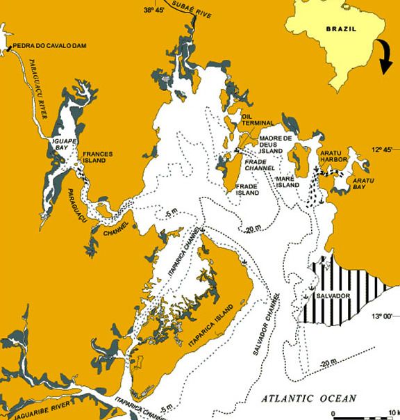
NE Brazil

                            NE Brazil

http://www.sea-seek.com   July 2018
NE Brazil

                                   Table of contents

       NE Brazil .............................................................................................................. 1
       1 - Porto do Itaqui (Maranhao Brazil)............................................................... 8
       2 - Port of Sao Luis (Maranhao Brazil) ............................................................. 9
       3 - Todos os Santos Bay (Bahia Brazil)............................................................ 11
               3.1 - Maragojipe quay (Bahia Brazil) ......................................................... 14
               3.2 - Estaleiro Aratu marina (Savador de Bahia)........................................ 16
               3.3 - Aratu Iate Clube (Aratu Salvador de Bahia))..................................... 17
               3.4 - Marina Pier Salvador (Bahia)............................................................. 18
               3.5 - Marina Angra dos Veleiros (Salvador de Bahia) ............................... 19
               3.6 - Marina Terminal Nautico (Salvador de Bahia) .................................. 19
               3.7 - Bahia Marina (Salvador de Bahia) ..................................................... 20
       4 - Fortaleza port (Ceara Brazil)...................................................................... 21
       5 - Porto De Maceio ........................................................................................... 22
       6 - Cabo de Sao Roque (Rio Grande do Norte)............................................... 23
       7 - Porto do Natal (Rio Grande do Norte Brazil)............................................ 24
       8 - Iate Clube do Natal (Rio Grande do Norte Brazil) ................................... 25
       9 - Ponta da Tabatinga (Rio Grande do Norte Brazil) ................................... 26
       10 - Bahia Formosa (Rio Grande do Norte Brazil)......................................... 27
       11 - Cabo Bacopari (Rio Grande do Norte)..................................................... 27
       12 - Porto De Suape (Pernambuco Brazil) ...................................................... 28
       13 - Ponta da Trincheira (Rio Grande do Norte)............................................ 29
       14 - Ribeira Adventure Club (Sao Paulo Brazil) ............................................ 30
       15 - Jacaré yacht village (Paraiba Brazil)........................................................ 30
       16 - Port do Cabedelo (Paraiba Brazil)............................................................ 32
       17 - Fernando de Noronha archipelago (Rio Grande do Norte Brazil) ........ 35

http://www.sea-seek.com                           July 2018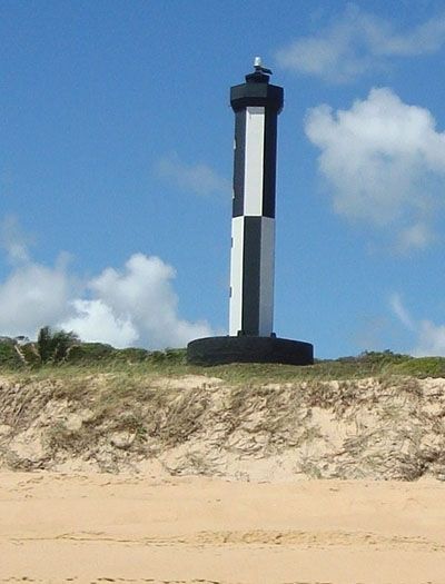
NE Brazil

17.1 - Bahia de Santo Antonio (F de Noronha N Brazil) ........................... 36

NE Brazil

                                                 6°30.42 S
NE Brazil                                       37°50.54 W
SW Atlantic Ocean - NE Brazil

http://www.sea-seek.com         July 2018          Page:1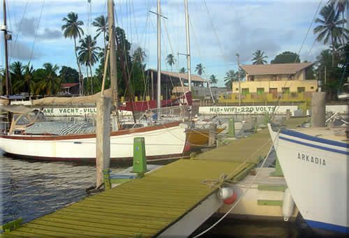
NE Brazil

                                              Brazil - South
                                                   Brazil is the only country in the
                                            world that lies on the equator while
                                            having contiguous territory outside the
                                            tropics. It occupies a large
                                            area along the E coast of S. America.
                                            Brazilian territory also includes a
                                            number of islands and islets.
                                            Southern Brazil has subtropical or
                                            temperate climate. The annual average
                                            temperatures vary between 12°C
                                            (53.6°F) and 22°C (71.6°F). It snows in
                                            the mountain ranges.
                                            Brazilian pleasure slowly takes off.
                                            Motor
boats are 80 to 90% of the market, while the "sailors" are rare, but quite dynamic.
Regarding moorings overall funds generally good holding.
On Amazon, during the summer, almost every day brings winds. It can be violent
(40 to 50 knots) but the risk of damage is low.
Yacht clubs are often local VIP clubs.
Marinas
 always have a security service 24 hours 24. At the entrance as on the
pontoons. This is necessary, especially when the latter adjoins a
favela.
The port facilities are highly variable. Some Brazilian
marinas sometimes offer free first days in port. The prices are very
variable (you can go from single to quadruple between a municipal port
and a private marina.)
Negotiate feasible, especially for a parking lot of a month or more.
Marinas ask the boat's papers and sometimes official entry documents in the
country.
Formalities
In
 case of your first-time arrival in Brazil, you have to arrange,
although not in a pressing way, for proper clearance. The different
departments are now all located in the town of Cabedelo ( easy access by
 the little train that stops in our village)

http://www.sea-seek.com           July 2018                                  Page:2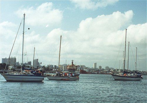
NE Brazil

You have 2 working
days for clearing formalities in the FOLLOWING order , whereby not just
the skipper but the whole crew has to be present.
1. Federal police (immigration) Requirements : passports of all crew and the
ships papers.
They
 will issue an individual tourist visa slip valid for 90 calendar days
and in a second step for another 90 days if desirable or necessary. So,
after all, you're only allowed to stay in Brazil for a total of 180
calendar days/year. At the time of clearing-in, a manifest with all the
names of the whole crew will be issued. This document has to remain on
board
Note : if some of the crew intend to leave before the scheduled
 sailing of the vessel, they only have to present themselves at the
airport with their individual touris visa slip and their passports. Just
 make sure NOT to lose that visa slip as otherwise some serious hassle
might pop up.
In case some of the crew intend to leave on another
vessel, they have to present themselves, with their passport and tourist
 slip, together with the new skipper at the time of clearing out.
2. Customs (Alfandega)- ships'papers and the doc. delivered by the Federal
Police.
3. Port Authorities (Capitania dos Portos) with the docs delivered under (1) &
(2).4. Health Authorities (Vigilancia Sanitaria)- with the compilation of everything
plus vaccination docs if any.
DON'
 t reverse this order as you may have wasted a trip. If one of the
authorities in the sequence isn't available, don't lose your temper,
just go back the following day.Locations and details :
The
 4 authorities are all located inside the port of Cabedelo premises or
just in front. The train station is quite near- get out on the right
hand side, follow the street parallel to the tracks until the port area,
 turn right and the port entry is 200m away. Just ask for ?Policia
Federal, then for Alfandega, afterwards for Capitania dos Portos and
finally for Vigilancia Sanitaria.
Be aware that most offices close

http://www.sea-seek.com           July 2018                                   Page:3

NE Brazil

between 11.30 am and 2 pm. As with ALL official places in Brazil, the
wearing of slacks is mandatory and when arriving in bermudas might have
access refused.
Generally speaking, the Brazilians are very
welcoming and the formalities usually don't result into a hassle. The
only thing one has to bear in mind, is that time hasn't got the same
value compared to the NW and NE Atlantic.
WHEN LEAVING :
* Brazil : the same formalities, with the exception of the Health Authorities, have
to be done in REVERSE order.
* For another sailing destination in Brazil, one has to clear-out at customs first
and then with immigration.
Visa extension :
As
 mentioned, one upon arrival receives automatically 90 days. If you need
 to stay longer, close to the end of the 90 d. one has to apply for for
an extension of up to another 90 days with the Federal Police in
downtown JOAO PESSOA . Bring with you passport(s), ship's papers and and
 entry paper and everybody concerned needs to be present. The charge is
R$25/person, payable at the bank opposite the Fed's building whereupon
with proof of payment one has to return to get the necessary stamps.
They're open Monday-Friday 8am-6pm although it's safer to go well before
 4 pm as all banks close at that hour.
Be aware:
1. Not to extend the 90 days before applying as everybody will be subject to a
daily fine of 8R$/calendar day.
2. The 180 days are the maximum one is allowed to stay in the territory of Brazil
in a given year.
Boat visa extension
Although
 your total stay in Brazil is limited to 180 days/year, your boat can be
 cleared to remain up to 2 years which allows you to go home or visit
other Latin-American countries.
Before leaving, you have to go to the
 port authorities (Capitania dos Portos) in JOAO PESSOA with a certified
 declaration from the caretaker (marina); thereupon proceed to the
Ministry of Finances (Receita Federal) in CABEDELO. Based upon the paper

http://www.sea-seek.com          July 2018                                   Page:4
NE Brazil

 issued by the Port Authorities, they will issue a free laisser passer
(void of all kind of import duties). Your only engagement is to declare
that within the time-frame you will take the boat out of Brazil and to
undertake that you will not sell part or the whole in Brazil.
                                               Brazil - South
                                                  Le Brésil s'étend de l'équateur au
                                             tropique du capricorne et occupe une
                                             vaste zone le long de la côte E de
                                             l'Amérique du S. Le territoire
                                             brésilien comprend également un
                                             certain nombre d'îles ou d'îlots.
                                             La Région Sud est la seule région
                                             brésilienne       localisée       presque
                                             totalement au-dessous du Tropique du
                                             Capricorne et, par cela même, est la
                                             plus froide du Brésil.
La caractéristique générale du climat du Sud est subtropicale présentant
 une sensible oscillation thermique pendant l'année. Il est possible de
différencier clairement deux saisons : l'hiver, qui peut être froid et
l'été, chaud, surtout dans les zones de basse altitude des trois États.
Peu
 développée jusqu'il y a quelques années, la plaisance brésilienne prend
 lentement son envol. Les bateaux à moteur représentent 80 à 90 % du
marché , tandis que les "voileux" sont rares, mais assez dynamiques.
En ce qui concerne les mouillages, globalement les fonds accrochent bien.
Les clubs nautiques sont souvent des clubs de VIP locaux.
Les
 marinas ont toujours un service de gardiennage 24 h sur 24. A l'entrée
comme sur les pontons. Ceci est nécessaire, surtout lorsque la marina
jouxte une favela.
Les installations portuaires sont très variables.
Certaines marinas brésiliennes offrent parfois la gratuité des premiers
jours à quai. Les prix sont très variables (on peut passer du simple au
quadruple entre un port communal et une marina privée.)
Négocier est faisable, surtout pour un stationnement d'un mois ou plus.
Les marinas demandent les papiers du bateau et parfois les documents officiels
d'entrée dans le pays.

http://www.sea-seek.com            July 2018                                   Page:5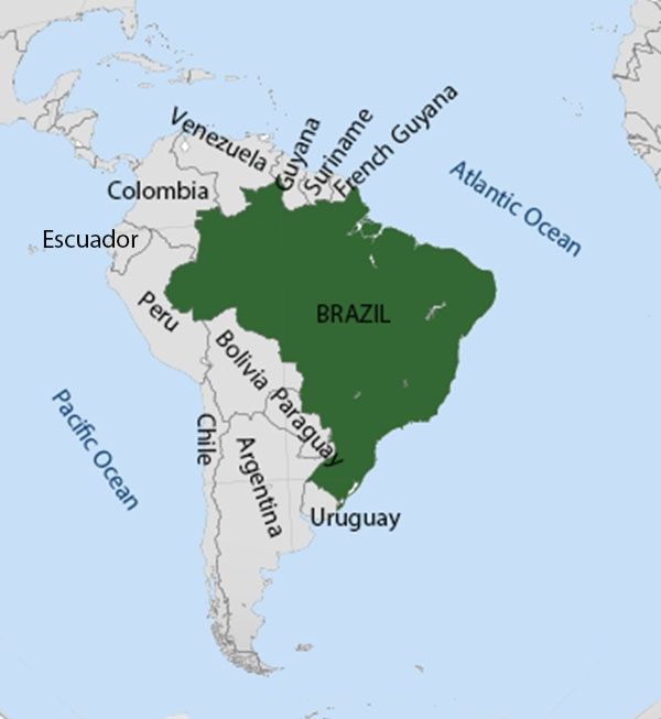
NE Brazil

Balisage:
On est en balisage IALA système B: vert à gauche et rouge à droite.
Formalités
Si
 vous touchez terre pour la première fois au Brésil, vous devrez faire
les formalités d'entrée sans pour autant vous précipiter ; Les
différents services sont maintenant tous regroupés á Cabedelo. (Accès
facile par le petit train qui s'arrête au village)
Vous avez 2 jours,
 ouvrables, pour faire votre entré au pays, à la Police Fédérale
(Immigration), puis aux douanes (« Alfandiga », à la « Receita Federal
»), puis à la capitainerie (« Capitania dos Portos »), et enfin à la «
Vigilancia Sanitaria » !...Mais ce délai reste assez « flexible »,
d'autant que tout le monde n'est pas forcément disponible sur le moment
mais tout devrait être bouclé dans la semaine. Habillez-vous en
pantalon, l'accés pourrait vous étre refusé si vous vous présentez en
short...

Première étape
Policia Federal et immigration :
Ils
 sont situés dans l'enceinte du port de Cabedelo, dans le bâtiment juste
 à droite de la guérite d'entrée. Lorsqu'on arrive par la gare, sortir
par la droite, suivre la parallèle à la voie ferrée jusqu'au port, puis
suivez à droite : l'entrée du port est à 200 mètres. Les services
d'immigration vous donneront un visa touristique de permanence au Brésil
 valable 3 mois ; il est renouvelable une fois ; c'est-à-dire que vous
avez droit de rester au Brésil au maximum 6 mois par année calendaire.
Si vous avez l'intention d'y laisser votre bateau en vous absentant du
pays, vous pouvez demander une extension de séjour sous douane pour le
bateau, laissé sous la garde d'une entité reconnue, qui peut aller
jusqu'à 2 ans.

Deuxième étape
Alfândega (Receita Federal, inistério da Fazenda) (fermés entre midi et 2 h.)
Amenez avec vous la documentations reçue de l'Immigration.
En

http://www.sea-seek.com          July 2018                                  Page:6
NE Brazil

 sortant du port, bien que la Capitania soit droit devant vous, tournez
d'abord à votre droite pour trouver le bâtiment rouge brique de la
Receita Federal sur votre droite, où vous devrez déclarer tout ce que
vous avez et n'avez pas à bord!
Troisème étape
Capitania dos Portos :
En face de l'entrée du port.
Elle
 est ouverte jusqu'à 18h. et son rôle consiste essentiellement à
garantir la sécurité de la navigation le long des côtes
brésiliennes.Allez y avec les documents de tout l'équipage et du bateau.
 Lorsque sous quittez l'escale, notifiez quelconque changement
d'équipage.
Quatrième étape
Vigilância Sanitaria :
Retournez
 dans l'enceinte du port, à côté du bâtiment de l'Immigration, munis de
vos carnets de vaccination, pour répondre à un questionnaire et
probablement prendre rendez-vous pour une visite à bord, sans grande
complication, rassurez-vous.
D'une manière générale, le brésilien
 est extrêmement accueillant, et toutes ces formalités se passent de la
meilleure façon, pour peu que vous réalisiez que la valeur du temps
n'est probablement pas la même ici que de l'autre côté de l'Atlantique.
Sortie :
Si vous quittez le territoire Brésilien, vous devez refaire les mêmes formalités en
sens inverse, sauf la Vigilance Sanitaire
Si vous quittez un port Brésilien pour un autre, il vous faut passer à la
Capitainerie et á l'immigration.
Prolongation de visa :Si
 vous avez besoin de rester plus de 3 mois au Brésil, vous devez aller
demander au service d'Immigration de la Police Federal de Joao Pessoa
une extension de votre visa initial, qui peut aller jusqu'à 90 jours. Ce
 service se trouve en centre ville, sur une petite place bordée de
charmants vieux arbres, située en haut d'une rue marchande que vous
trouverez sur la droite de la place de Lagoa
Tous les bus qui vont de Cabedelo à Joao Pessoa passent par Lagoa.

http://www.sea-seek.com           July 2018                                  Page:7
NE Brazil

Emportez
 votre passeport, des papiers du bateau, et votre reçu d'Entré au Brésil
 ; vous aurez un formulaire à remplir, puis aurez une taxe de l'ordre de
 R$ 25,00 (par personne) à aller payer à la banque en face, après quoi
vous devrez retourner au service d'Immigration pour y recevoir le tampon
 de votre nouveau visa (toutes les personnes concernées doivent être
présentes). Bureaux ouverts de lundi à vendredi, de 8h à 16h, mais ferme
 entre 11h30 et 14 h.
Prolongation du « visa » du bateau :
Bien
que votre séjour total au brésil ne puisse excéder 6 mois, votre bateau
peut, lui, rester jusqu'à 2 ans, ce qui signifie que vous pouvez laisser
 le bateau pour visiter par voie terrestre ou aérienne d'autres pays
d'Amérique latine, ou rentrer quelques mois dans votre pays d'origine,
par exemple.
Pour ce faire, avant de quitter le Brésil, vous devez :
Aller
 à la Capitania dos Portos de Joao Pessoa munis d'une déclaration
estampillée de l'entité reconnue (marina) qui a la garde de votre bateau
 et d'une procuration; puis passer à la Receta Federal de Cabedelo, qui,
 au vue de ce document visé par la Capitania, vous ferra une extension
de droit de séjour sous douane de votre bateau (sans aucune taxe
d'importation à payer), en vous sous engageant à revenir pour quitter le
 Brésil avec.
                                                                        2°34.63 S
1 - Porto do Itaqui (Maranhao Brazil)                                  44°22.24 W
SW Atlantic Ocean - NE Brazil

http://www.sea-seek.com         July 2018                                  Page:8
NE Brazil
14, 16
Located on the coast of São Luís,
the state capital, the port has a deep
access channel and berths, enabling
the mooring of large ships.
Port of Itaqui is the largest cargo port in
Brazil, near the city of São Luís,
Maranhão. It is not to be confused with
the city of Itaqui, in the state of Rio
Grande do
Sul, near the border with Argentina. The main cargoes include aluminum ingots
and bars, pig iron, general, dry and liquid bulk cargoes, soybean and copper.
The Port of Itaqui has 7 operational berths and 1 new petroleum pier
to be released in December 2014 (berth 108), with depths that vary from
10-18 meters, and 2 kilometers of wharfs.
The port has a large bonded area of approximately 117,000 m².
Phone: +55 (98) 3216-6000
Mail: comunicacao@emap.ma.gov.br
2°30.35 S
2 - Port of Sao Luis (Maranhao Brazil) 44°19.24 W
SW Atlantic Ocean - NE Brazil
http://www.sea-seek.com July 2018 Page:9NE Brazil
The port of Sao Luishas silted up
and has ceased to be important as a
port after the construction of the port of
Itaqui.
The port of Sao Luis is used mainly by
fishing boats and pleasure craft. It has
a few piers that allows mooring, but
only at flood tide, to ships of 2,5 to 3,5
draft.
Cruisers are urged to take precautions if visiting this port. Policia Federal
(immigration) and Customs are at the port
entrance.
The historical center is at 30 minutes drive away.
Anchor south of Itaqui, near all the pilot boats and tugs. Good
holding in mud. It is possible to tie the dinghy near a sloping ramp
and climb the slippery steps to get ashore.
There is a sort of marina, Marina Aven, which appears to
dry out completely at low water and thus only suitable for catamarans or
others who can sit on the bottom. They have a dock space for four
yachts and (rain?) water is available.
http://www.sea-seek.com July 2018 Page:10NE Brazil
12°51.38 S
3 - Todos os Santos Bay (Bahia Brazil) 38°40.07 W
SW Atlantic Ocean - NE Brazil - Todos os Santos Bay (Bahia Brazil)
A Maragojipe quay (Bahia Brazil) B Bahia Marina (Salvador de Bahia)
C Marina Terminal Nautico (Salvador de Bahia) D Marina Pier Salvador (Bahia)
E Marina Angra dos Veleiros (Salvador de Bahia) F Aratu Iate Clube (Aratu Salvador de Bahia))
G Estaleiro Aratu marina (Savador de Bahia)
http://www.sea-seek.com July 2018 Page:11NE Brazil
Todos os Santos Bay (Bahia Brazil)
The bay of All Saints (Baia de
Todos os Santos in Portuguese), also
known as "All Saints'Bay" and "Todos
os Santos Bay", is the principal bay of
the Brazilian state of Bahia, on the
eastern coast of Brazil, surrounding
part of Bahia's capital Salvador and
opening to the Atlantic Ocean.. It is the
largest bay in Brazil which offers a
multitude of marinas and anchorages.
Cruisers are warned not to visit
secluded anchorages in the Bahia de
Todos os Santos. It is also strongly
recommended that, unless taking up a berth in one of
the marinas, vessels should avoid anchoring in the Port area where
several armed boardings and robberies have taken place.
For clearance, all the offices are located in the main port. You will be
required to check in with the Policia Federal before you proceed to the
Capitania Dos Portos. The Policia Federal is located next to the
Receita Federal in the main port, ten minute walk from the Capitania.
Enter the waterfront side of the port at the passenger terminal (about
200 meters further down), and then backtrack along the waterside of the
port to the Policia Federal office (hours 9-12/2-5 Mon-Fri and 9-12
Sat).
Checking in with the Policia Federal is mandatory here.
The staff at both marinas are most helpful and will advise about formalities
Capitania dos Portos
Tel:+55 71 3320-3759
http://www.sea-seek.com July 2018 Page:12NE Brazil Fax:+55 71 3320-3811 Situated in the white Navy complex next to the harbour. Guard will direct you after seeing your passport and a visitor pass will be issued. The approach is straight forward and deep, but with surprisingly strong currents in the middle of the bay and also at the northern end. The night approaches are well marked to all the marinas. Beware of wrecks off the cape on the eastern side of the entrance to the bay. There are a number of yacht clubs in and around Salvador, and repair facilities at some of them are very good as they cater for a large local boating community. Aratu Iate Clube Rodovia Paripe ? CIA, , S/N, Simoes Filho http://www.sea-seek.com July 2018 Page:13
NE Brazil

Tel:+55 071 32167444
Bahia Yacht Club

Sete de Septembro 3252
, Salvador BA
, Brazil CEP 40130 001

Tel:+55 (0)71 3336 9011

,VHF Channel 16, 68
                                                                                          12°46.94 S
3.1 - Maragojipe quay (Bahia Brazil)                                                      38°54.36 W
SW Atlantic Ocean - NE Brazil - Todos os Santos Bay (Bahia Brazil)

          in front of the Pier, good holding     chan 72 - soniva                foreseen voor 2010

   famous vegetable market every Saturday morning                    mangroves

http://www.sea-seek.com                        July 2018                                    Page:14
NE Brazil
After rounding the fort of Paraguaçu
(or Salamina), we arrive at "l'île du
Français" (llha do Francês). At left, just
after the island, is Maragojipe at the
mouth of rio Guai.
The city has a concrete pier more than
100 meters long.
Maragojipe is located in a sheltered
place, against the
Rio Paraguaçu and Rio Guai.
Good holding anchorage (mud) except in the middle of the river. Don't approach
the town (bottom up quickly).
plan de FORMALITES ADMINISTRATIVES à votre entrée à BAHIA
Quand vous arrivez à Salvador da Bahia vous devriez faire les démarches
administratives suivantes (dans l'ordre indique sinon vous risquez de faire
quelques aller/retour pour rien ;-) toutes indiqués sur notre petite carte routiere
1. visite de la ANVISA (Agencia Nacional de Vigilânçia Sanitária - services
sanitaires) avec vos pasport(s) (si vous êtes vacciné prenez les docs)
2. visite de la Policia Federal avec le document de l'Anvisa + carnet de bord +
pasport(s)
3. viste de la Reiceita Federal pour déclarer votre bateau avec le document de la
Policia Federal + carnet de bord + pasport(s)
4. visite de la Capitania dos Portos avec les documents des instances
submentionnées + carnet de bord + pasports(s)
Conseil, partez vers 10h ... vous pourriez y passer facilement plus de 2h en total
ET la capitania n'accepte les étrangers qu'a partir de midi pour les inscriptions de
bateaux
Pour vous aider a retrouver votre chemin quelques indications précises (à partir
de la marina CENAB) :
1. sortez de la marina et longez l'avenida da França (le long du mur
'pipi' des hangars de quai) jusqu'au moment (+/- 500m) ou vous voyez que le mur
peint blanc change en briques naturelles rouges, là vous avez l'entrée des
passagers pour le port de Salvador (si la porte est fermée vous pouvez allez
jusqu?à à l'entrée des voitures avec la barriere), quand vous êtes sur le quai
vous continuez au nord et +/-
600m plus loin vous pouvez entrer le bureau de l'Anvisa, montez l'escalier au
premier et rentrez dans la premiere porte à droite et présentez vous.
http://www.sea-seek.com July 2018 Page:15NE Brazil
2. quand vous sortez de l'Anvisa, prenez à gauche (d?où vous venez) vers la
Police Fédérale, vous refaites tout le trajet le long du quai et vous continuez
encore
200m après l'entrée jusqu'au moment ou vous voyez de un petit parking, juste
avant le parking il y a le batiment de la PF (il y a une grande barre metalique
devant la porte qui évite de se garer devant, entrez, dans le couloir la première
porte à gauche, ici soyez très gentil (surtout gardez le calme !), la "madame" du
bureau n'est pas évidente/facile à traiter et elle ne parle ni français ni anglais ...
3. quand vous avez survécu la PF en sortant du batiment tournez tout de suite à
gauche sous le parking couvert et dirigez vous vers la fenêtres ou vous pouvez
déclarer l'entrée du bateau à la Receita Federal
4. une fois fini dirigez vous vers la sortie du quai et repartez direction marina, une
fois la vous continuez a longer l'eau (passez le poste essence) jusqu?à la base
militaire ou vous entrez, après se faire identifier vous allez à gauche jusqu?à
l'avant dernier bâtiment (main droite) porte de milieu pour faire les formalités de
la Capitania dos Portos
Bon, pratiquement maintenant : vous avez un droit (visa) d'être au Brésil pour 90
jours, idem pour votre bateau, après vous pouvez prolonger de
90 jours MAIS pour cela vous devez aller à l'aéroport pour le visa et après
repasser par la Receita Federal pour le voilier, après ... vous dev(ri)ez sortir du
pays pour 6 mois minimum. Le bateau par contre peut rester jusqu?à 2 ans mais
vous devez le garder dans une marina ET vous devez faire la demande officielle
chez la Receita Federal. Pour la Capitania vous ne devez rien faire jusqu'à votre
sortie de Bahia.
Vous pouvez me contacter quand vous êtes au mouillage a Maragojipe
(12°46.9471 S- 038°54.3682 O) via la VHF canal 72 quand je suis au village la
VHF est en veille, ou venez me visiter à mon volier le "Basile" à l'ancre devant le
ponton, ou contactez-moi par mail ou msn sur ixanthes (a) gmail.com
Bon vent et à bientôt
Ivan
12°48.51 S
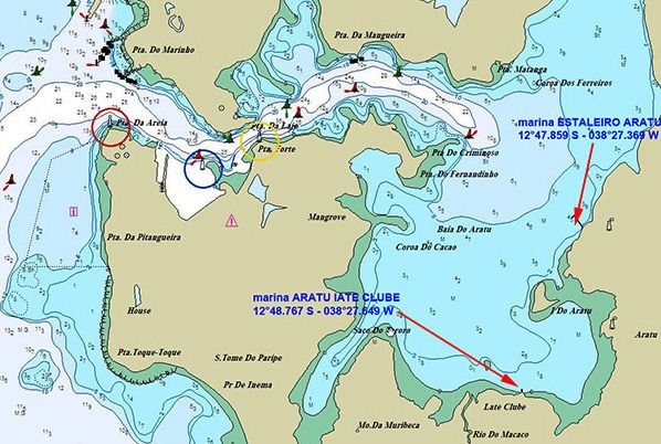
3.2 - Estaleiro Aratu marina (Savador de Bahia) 38°27.29 W
SW Atlantic Ocean - NE Brazil - Todos os Santos Bay (Bahia Brazil)
16
http://www.sea-seek.com July 2018 Page:16NE Brazil
Phone: (71} 3594-7373 fax: (71)
3594-9393
e-maii:
marinaaratu@marinaaratu.oorn.br
12°48.70 S
3.3 - Aratu Iate Clube (Aratu Salvador de Bahia)) 38°27.59 W
SW Atlantic Ocean - NE Brazil - Todos os Santos Bay (Bahia Brazil)
http://www.sea-seek.com July 2018 Page:17NE Brazil
Towards the bottom of the Bay of All
Saints, to starboard, there is a marked
channel that
leads to the bay of Aratu.
It is from there that share the most contributes regatta Bahia, the place of arrival
is Maragogipe, in August, in honor of Saint Bartholomew, the saint patron of the
city.
Phone: (71) 3216-7444 / 7303 / 3216-5138 fax: (71) 3216-5138
e-mail: aratuclube@uol.com.br
12°54.70 S
3.4 - Marina Pier Salvador (Bahia) 38°29.51 W
SW Atlantic Ocean - NE Brazil - Todos os Santos Bay (Bahia Brazil)
http://www.sea-seek.com July 2018 Page:18NE Brazil
A friendly marina in the sheltered
Itapajipe bay, N of Salvador city. All
facilities, laundry, WiFi, chandlery,
restaurant, small shop. Nearby
bus into the city. Owner speaks
English and French and is most helpful.
A good place to leave the boat. At LW
1.4m in the approach channel.
Phone: (+55) 71 3316 1406
Fax:(+55) 71 3316 1406 e-mail: tropicalfun@tropicalfun.com.br
12°54.76 S
3.5 - Marina Angra dos Veleiros (Salvador de Bahia) 38°29.48 W
SW Atlantic Ocean - NE Brazil - Todos os Santos Bay (Bahia Brazil)
Floating marina, floating dock, bar,
restaurant and VHF radio.
Tel/Fax: (71) 3316-5628 e-mail:
angradosveleiros@terra.com.br
12°58.34 S
3.6 - Marina Terminal Nautico (Salvador de Bahia) 38°30.93 W
SW Atlantic Ocean - NE Brazil - Todos os Santos Bay (Bahia Brazil)
http://www.sea-seek.com July 2018 Page:19NE Brazil
The marina has floating docks, with
a potential swell running snubbers
are recommended. Helpful staff.
Cheaper than Marina Bahia.
Tel: (71) 3319-3434 fax : (71)
3326-3433
e-mail: cenab@cenab.com.br - www.cenab.com.br
12°58.71 S
3.7 - Bahia Marina (Salvador de Bahia) 38°31.27 W
SW Atlantic Ocean - NE Brazil - Todos os Santos Bay (Bahia Brazil)
16, 68
http://www.sea-seek.com July 2018 Page:20NE Brazil
Bahia Marina offers customers and
users complete infrastructure.
Consists of:
* Bowl berth of 176,000 m2;
* 400 wet empty marina spaces on
aluminum floating piers, with access
control equipped with lampposts, all
with electricity and water meters taken
at each point to encourage rational use
of water ;
* 200 dry empty parking spaces on the outdoor patio with access control;
Courtyard for docking with 5,000 m²;
* Travel Lift, modern and safe equipment for handling vessels up to 40 tons;
* Station SSB and VHF radio signal and Wi-Fi;
* Parking on three floors with 560 available empty spaces;
* Floating Gas Station;
* Stores of nautical products, vessels, conveniences, maintenance services
(mechanical, hull, sail, electric-electronics etc.).
The area just outside this marina can be dangerous and it is advisable to use a
taxi even for short distances, day and night.
Phone +55 (0)71 3322 7244
Fax:+55 (0) 71 3322 7244 e-mail: bmarina@bahiamarina.com.br
3°42.36 S
4 - Fortaleza port (Ceara Brazil) 38°28.80 W
SW Atlantic Ocean - NE Brazil
http://www.sea-seek.com July 2018 Page:21NE Brazil
This is the most important city on Marina Park Hotel Fortaleza
the north
coast and is also a busy fishing harbour.
For the unsuspecting, the bay is littered with wrecks (those not buoyed
show above the water), and the water shallows quickly, so care should be
taken on entry. Lights on the buoys can be undetected from over 50m
away.
Visiting cruisers warn that parts of the city (including areas round
the Park Hotel) are not safe, recommending to travel in groups and use a
taxi instead of public transport. However, much of Fortaleza is fairly
upscale with nice shopping and dining.
Credit card fraud is a problem here, so take extra care if using one.
It is possible to anchor at the commercial harbour on arrival to
check in. This anchorage however is not safe and there's no where to
leave your dinghy when going ashore. The alternative is to berth at the
marina and make the necessary office visits by taxi.
Phone: +55 85 3266 8800
Fax: +55 85 266 5211
Offices are open every day, 24 hours, and cruisers report not being charged
overtime on a Saturday.
Most visitors moor at the Marina Park Hotel, to the west. A night entry
should be avoided as many boats string lines right across the marina.
The anchorage off the Yacht Club is reported as unsafe following frequent
robberies from yachts anchored there.
Tel:+55 85 263 1744
Fax:+55 85 263 2099
9°40.88 S
5 - Porto De Maceio 35°43.57 W
SW Atlantic Ocean - NE Brazil
http://www.sea-seek.com July 2018 Page:22NE Brazil
Port protected by a breakwater.
Port protégé par une digue.
5°28.93 S
6 - Cabo de Sao Roque (Rio Grande do Norte) 35°15.67 W
SW Atlantic Ocean - NE Brazil
sandy point, about 55m high, with vegetation on its summit. It is closest to the
continent of Africa.
It also marks the separation of French Guiana (where the coast is low and
swampy) and the State of Rio Grande do Norte that offers to S, a massive coast
http://www.sea-seek.com July 2018 Page:23NE Brazil
with many coves and bays.
Finally, the South Equatorial Current arrive here from the Gulf of Guinea and is
divided into two branches: the Brazil Current, to S, and the North Equatorial
Current, from the west, to the Caribbean (where it takes name of Gulf Stream).
A light is shown, S of cape, built in 1898.
Between Cabo de Sao Roque and Punta de Santa Rita, 13 miles SSE, the coast
has no remarkable features. It is backed by hills from 35 to 60m high, which are
sparsely wooded, and has several villages and coconut groves along it.
Cap sablonneux d'environ 55m de
haut, avec de la végétation à son
sommet. C'est le plus proche du
continent africain. Il marque en outre la
séparation entre la Guyane française
(où la côte est basse et marécageuse)
et l'Etat du Rio Grande do Norte qui
offre, vers le S, une côte plus massive
avec beaucoup de criques et baies.
Enfin, le courant sud-équatorial arrive ici du golfe de Guinée et se divise en deux
branches: le courant du Brésil, vers le S, et le courant nord-équatorial, vers l'W,
jusqu'aux Caraïbes (où il prend le nom de Gulf Stream).
Le cap porte un phare au S, construit en 1898.
Entre Cabo de Sao Roque et Punta de Santa Rita, à 13 miles au SSE, la côte n'a
pas rien de notable. Elle est couverte de collines de 35 à 60m de haut, qui sont
peu boisées, et de plusieurs villages et plantations de cocotiers.
5°46.12 S
7 - Porto do Natal (Rio Grande do Norte Brazil) 35°12.28 W
SW Atlantic Ocean - NE Brazil
http://www.sea-seek.com July 2018 Page:24NE Brazil
The port of Natal is situated at the mouth of the Rio Pontengi. The river flows
into the sea through an opening in the barrier reef. The barrier reef forms a
natural breakwater for the port.
The prevailing winds most of the year are from the ENE to SE.
Formalities can be carried out at the yacht club.
If this is your final port of call in Brazil, you will need to go to
the Policia Federal in Natal, half an hour away by car, and the Receita
Federal Office and Capitania Dos Portos in the nearby port.
There is a good anchorage in front of the yacht club or you can pick
up a mooring, taking care of the movements of the other boats swinging
around in the strong (ebb) current; the flood is not so strong. Use an
anchor light. Depths around 9 to 11 metres.
There is also a good anchorge at Rio Potengi.
Provisioning is easy at several supermarkets in the city.
C'est un port de commerce situé à
l'embouchure du fleuve Pontengi. Cette
rivière se jette dans la mer grâce à une
ouverture dans la barrière de corail qui
forme un brise-lame naturel pour le
port.
Les vents dominants, la plupart de
l'année, sont en provenance du ENE à
SE.
Pour la plaisance, il faut aller mouiller devant le club nautique un peu avant, au
nord.
Tel: 84 4005 5311
Mail: administrativo@codern.com.br
5°45.90 S
8 - Iate Clube do Natal (Rio Grande do Norte Brazil) 35°12.26 W
SW Atlantic Ocean - NE Brazil
http://www.sea-seek.com July 2018 Page:25NE Brazil The Iate Clube do Natal marina is in the town of Monsenhor Gil (Brazil). Visiting yachtsmen welcomed. Good general repair facilities. Water, showers (cold water), bar and restaurant. (Pool & recreational facilities not open to visitors). Wifi and laundry services available. The club can help with formalities. Fuel (if taking from the transit dock, dirty fuel has been reported. Tel: +55 84 3202-4402 90 pl. (
NE Brazil

  Ponta da Tabatinga is about 18 miles SSE of Natal. It is of a reddish color and
marked by a light.
                                             Ponta da Tabatinga est située à
                                        environ 18 miles au SSE de NataL. Elle
                                        est de couleur rouge et marquée par un
                                        feu.

                                                                         6°21.99 S
10 - Bahia Formosa (Rio Grande do Norte Brazil)                         35°00.74 W
SW Atlantic Ocean - NE Brazil

  It is possible to anchor in baia Formosa, in depths of 7 to 9 m.
Sheltered from S and SE winds.
                                                 On peut mouiller dans la baie
                                          Formosa, par 7 à 9 m.
                                          Protégée des vents du S et SE.

                                                                         6°22.05 S
11 - Cabo Bacopari (Rio Grande do Norte)                                35°00.24 W
SW Atlantic Ocean - NE Brazil

http://www.sea-seek.com         July 2018                                 Page:27
NE Brazil
Cabo Bacopari closes baia Formosa and shows a light.
Le cap Bacopari ferme la baie
Formosa et porte un phare.
8°23.93 S
12 - Porto De Suape (Pernambuco Brazil) 34°57.13 W
SW Atlantic Ocean - NE Brazil
http://www.sea-seek.com July 2018 Page:28NE Brazil
Port protected by a breakwater.
6°40.54 S
13 - Ponta da Trincheira (Rio Grande do Norte) 34°55.94 W
SW Atlantic Ocean - NE Brazil
Ponta da Trincheira lies 19 miles SSE to Cabo Bacopari. A light is on a reef
that lies close E of the point.
Ponta da Trincheira se trouve à 19
miles au SSE du cap Bacopari. Un
phare se trouve sur un rocher qui
s'étend à l'E de la pointe.
http://www.sea-seek.com July 2018 Page:29NE Brazil
7°01.77 S
14 - Ribeira Adventure Club (Sao Paulo Brazil) 34°52.28 W
SW Atlantic Ocean - NE Brazil
Bow-to and Stern-to moorings for
about 10 boats plus anchor space.
Water, electricity and internet use
available. Drinks and tapas at
Luciano?s small bar. Speaks Spanish
and English. Regular water taxis.
Although the channel leading up to this
mini-marina is not sufficiently
deep to admit the average deep
draught
cruising yacht, centreboarders,
catamarans, and smaller yachts can get through.
Phone 55 83 3665.5003 - 55 83 9 9805.6105
7°02.28 S
15 - Jacaré yacht village (Paraiba Brazil) 34°51.34 W
SW Atlantic Ocean - NE Brazil
68
http://www.sea-seek.com July 2018 Page:30NE Brazil
It is best to proceed up the river to Jacare, but beware of the many
shoals and strong currents. It is advisable not to use a "danforth"
type anchor as it can more easily be tripped when the tide turns.
Beware of the unlit fishing nets strung across the river.
At Jacare, yachts can anchor in front of the "yacht club". Although this is no
longer a "club", dinghies can be left here during the week.
Jacare Yacht Village (or Marina Jacare Village) have much-improved facilities for
cruising yachts. You can independently anchor close to the marina or tie up to
one of their mooring buoys or docks.
What was once a fishing village has now become a busy resort, popular
with the Brazilian jet-set and notorious for its all-night music.
Everywhere in Jacare noise can be a problem.
40 berth marina with water and electricity - inner docks are shallow,
outer docks depth 4.5m. Clean showers, laundry, wifi, small swimming
pool, bar/restaurant.
Able to organize entry formalities (they will go with you or send a
driver with you) and assist with finding parts and repairs. The driver
knows everyone. Owner Nicolas is a sailor and used to help organize
transatlantic rallies. Very safe and a good place to leave a boat for a
long period. French, English, Brazilian all spoken. Useful website with
local information and entry waypoints.
Tel: + 55 83 87 39 11 44 or +55 83 86 00 67 98
http://www.sea-seek.com July 2018 Page:31NE Brazil
2011:12:26 16:22:27
...
Tout est dit ci-dessus, sauf que
l'électricité n'est pas facturée en plus.
La police fédérale est dans un bâtiment
"proche" de Jacaré (taxi...), les
douanes et affaires maritimes sont au
port de Cabedello (encore taxi, le
même...) mais on peut revenir en train,
folklorique, à faire absolument.
On peut aussi aller en train jusqu'à Joao Pessoa.
Bien le bonjour à Philippe et Francis qui vous aideront dans tous vos besoins.
6°58.32 S
16 - Port do Cabedelo (Paraiba Brazil) 34°50.40 W
SW Atlantic Ocean - NE Brazil
Cabedelo is situated approximately 100MN south of Natal where the Rio
Paraiba enters the sea. It's location makes it a useful arrival/departure point for
Brazil. It is situated on the eastern bank of the Northern Paraíba River Estuary,
http://www.sea-seek.com July 2018 Page:32NE Brazil just 18 km from João Pessoa City, Capital of the State of Paraíba. Entry is possible day or night, as the channel is well marked with buoys. Note however that quite often some of these are not working, so if your first time it's advisable to avoid a night entry. It is a good place to leave the boat if exploring the interior. Clearance should be completed within two working days of arrival. The order in which you visit the various officials is important, otherwise, you might have a wasted journey. If one is not available, just return the next day. Visit Immigration (Federal Police) first, followed by the Customs (Alfandega) with the ships?papers and the document provided by the police, then the Health Authorities (Vigilancia Sanitaria) with any vaccination documents and finally the Port Authority with all the papers presented and provided so far and all the documentation previously accumulated. Remember, all the crew has to be present.There is a marina close to Joao Pessoa, capital of Paraíba state. The police visit the marina every day and one can drive with them to check in at Cabedelo where there is also a customs office and the port captain's office. This is in front of the harbour entrance in Cabedelo. If Jacare is your first port of call, take the train from the station next to Jacare Wharf to Cabedello (20 minutes). It is now possible to complete all the formalities at the harbour. Alternatively, if staying at the marina here, they will assist you with doing formalities, all very quick and easy. All the authorities are all located inside the port of Cabedelo premises or just in front. The train station is quite near (get out on the right hand side), follow the street parallel to the tracks until the port area, turn right and the port entry is 200m away. Just ask for ?Policia Federal?, then for Alfandega??, afterwards for ?Capitania dos Portos? and finally for ?Vigilancia Sanitaria.?. Remember most offices close between 11.30 am and 2 pm. Normally you will be granted a 90 day visa which can be extended for another 90 days, but be sure to get the extension before the initial 90 days expires as there is a fine for each day otherwise. This coast is fringed by reefs, so it is important to make for the outer buoy of the approach channel. The entrance and channel are well marked but not all beacons http://www.sea-seek.com July 2018 Page:33
NE Brazil

are lit. The river is also quite wide with several shallow areas, so
unless you know the place well it is advisable to do a daytime entry or
exit. Jacare Village marina have a list of entry points on their
website.
Once inside the harbour, keep close to the quay, after which, move
to the centre of the river Paraiba. There is a shoal in front of
Favella and anchoring near here is not recommended.
Phone: +55 83 3228 2030
Fax: +55 83 3228 2033
                                                  Port de commerce
                                              L'entrée du port de Cabedelo, au est
                                              située sur la pointe extrême Est du
                                              continent Sud Américain.
                                              « Jacaré » (ce qui signifie Crocodile,
                                              mais vous aurez bien du mal à en
                                              trouver un !) est à 2 miles derrière le
                                              port (07°02?S, 34°51W) dans l'estuaire
                                              abrité du rio Paraïba ; c'est une escale
                                              connue de bouche à oreille depuis les
                                              années 70, réputée
calme et sûre, avec un chenal d'entrée bien balisé, de jour comme de nuit (ce qui
n'est pas souvent le cas sur la côte du Brésil).

http://www.sea-seek.com            July 2018                                  Page:34
NE Brazil
3°50.72 S
17 - Fernando de Noronha archipelago (Rio Grande do Norte
32°25.39Brazil)
W
SW Atlantic Ocean - NE Brazil - Fernando de Noronha archipelago (Rio Grande do Norte Brazil)
A Bahia de Santo Antonio (F de Noronha N Brazil)
Fernando de Noronha is an archipelago of 21 islands and islets in the Atlantic
Ocean, 354 km offshore from the brazilian coast. The archipelago got its name
from the Portuguese merchant Fernão de Loronha, to whom it was given by the
Portuguese crown for services rendered regarding wood imported from Brazil.
It is a nationa maritime park. In 2001 UNESCO designated it as a World Heritage
Site because of the importance of its environment.
The islands of this archipelago are the visible parts of a range of
submerged mountains. It consists of 21 islands, islets and rocks of
http://www.sea-seek.com July 2018 Page:35NE Brazil
volcanic origin. The main island has an area of 18 km2 (6.9 sq mi), being
10 km (6.2 mi) long and 3.5 km (2.2 mi) wide at its maximum. The base of
this enormous volcanic formation is 756 metres (2,480 ft) below the
surface.
The main island, from which the group gets its name, makes up 91% of the
total area; the islands of Rata, Sela Gineta, Cabeluda and São José,
together with the islets of Leão and Viúva make up the rest. The central
upland of the main island is called the Quixaba.
The life above and below sea is the main attraction of the island. Sea
turtles, dolphins, albatrosses and many other species are frequently
observed.
Fernando de Noronha
L'archipel a été découvert en 1500
par le navigateur portugais Gaspar de
Lemos, Elle est un exemple de
préservation de l'environnement et
possède le statut de Parc Naturel.
Il est aussi sur la liste du Patrimoine
Mondial de l'Unesco.
3°49.88 S
17.1 - Bahia de Santo Antonio (F de Noronha N Brazil) 32°24.24 W
SW Atlantic Ocean - NE Brazil - Fernando de Noronha archipelago (Rio Grande do Norte Brazil)
http://www.sea-seek.com July 2018 Page:36NE Brazil
It is a natural anchorage place, just
off the breakwater, which provides
protection for the dinghy when landing.
However, this anchorage is reported to
be rolly. In the winter months
(July) the seas here are generally calm.
A stone pier was built for tieing up
small
ships. Bigger ships remain
anchored about 500 m from the beach, as there is a sinked greek ship -
the Eleani Sthatathos - in the harbour.
In the proximity there is the Sto. Antonio Fort, which is partly
destryoed; it was the first of the main island forts and its name was
taken over by the entire region.
Visiting yachts are also allowed to anchor along the shore between
the harbour and the twin islands of Dois Irmaos. This is the only area
in the National Park with no anchoring restrictions.
Anchor in 10 to 14m over hard sand (and rock).
http://www.sea-seek.com July 2018 Page:37NE Brazil
www.sea-seek.com
Responsability Responsabilité
Sea-Seek is a collection of sailing Sea-Seek est un guide du nautisme
logbooks covering harbours, ou pilote côtier en ligne. Fruit de la
anchorages, diving spots... any contribution de chacun, il décrit les
subject regarding sport or pleasure at sites de mouillage, les ports, les spots
sea. de plongée, les plages par et pour les
amoureux de la mer.
Sea-Seek is an online open-content
collaborative pilot guide, that is, a Sea-Seek est un guide nautique libre,
voluntary association of individuals c'est-à-dire une association volontaire
and groups working to develop a d'individus et de groupes qui
common resource of human développent ensemble une source de
knowledge. The structure of the la connaissance humaine. Sa
project allows anyone with an Internet structure permet à tout individu avec
connection to alter its content. Please un accès Internet et un navigateur
be advised that nothing found here Web de modifier le contenu disponible
has necessarily been reviewed by ici. En conséquence, sachez que rien
people with the expertise required to de ce que vous pouvez trouver ici n'a
provide you with complete, accurate été nécessairement vérifié par un
or reliable information. professionnel compétent dans le
domaine en question et ceci sur tous
In particular, don't use any map les sujets de Sea-Seek.
presented in Sea-Seek for the
navigation. En particulier, n'utiliser aucune carte
de Sea-Seek pour la navigation.
Note that informations in sea-seek are
compiled from a variety of freely L'ensemble des données présentées
available and non controlable sources sur Sea-Seek sont d'origines diverses
and therefore Sea-Seek webmaster et non contrôlées et ne sauraient
cannot be held responsible for engager la responsabilité du
incorrect or outdated data. responsable du site
www.sea-seek.com.
http://www.sea-seek.com July 2018 Page:38You can also read