The Phantom Fleet North Korea's Smugglers in Chinese Waters - James Byrne, Joe Byrne, Gary Somerville and Hamish Macdonald - RUSI
←
→
Page content transcription
If your browser does not render page correctly, please read the page content below
Royal United Services Institute
for Defence and Security Studies

PROJECT SANDSTONE, No. 6

The Phantom Fleet
North Korea’s Smugglers in Chinese Waters
James Byrne, Joe Byrne, Gary Somerville and Hamish Macdonald
2                                                                                                            The Phantom Fleet

About RUSI

The Royal United Services Institute (RUSI) is the world’s oldest and the UK’s leading defence and security think tank.
Its mission is to inform, influence and enhance public debate on a safer and more stable world. RUSI is a research-led
institute, producing independent, practical and innovative analysis to address today’s complex challenges.

Since its foundation in 1831, RUSI has relied on its members to support its activities. Together with revenue from research,
publications and conferences, RUSI has sustained its political independence for 189 years.

The views expressed in this publication are those of the authors, and do not reflect the views of RUSI or any other
institution.

Published in 2020 by the Royal United Services Institute for Defence and Security Studies. RUSI is a registered charity (No.
210639).

This work is licensed under a Creative Commons Attribution – Non-Commercial – No-Derivatives 4.0 International Licence.
For more information, see .

Terms and Conditions

This document has been prepared by RUSI for informational purposes only (the ‘Permitted Purpose’). While all reasonable
care has been taken by RUSI to ensure the accuracy of material in this report (the ‘Information’), it has been obtained
from open sources and RUSI makes no representations or warranties of any kind with respect to the Information.

You should not use, reproduce or rely on the Information for any purpose other than the Permitted Purpose. Any reliance
you place on the Information is strictly at your own risk. If you intend to use the Information for any other purpose
(including, without limitation, to commence legal proceedings, take steps or decline to take steps or otherwise deal
with any named person or entity), you must first undertake and rely on your own independent research to verify the
Information.

To the fullest extent permitted by law, RUSI shall not be liable for any loss or damage of any nature whether foreseeable or
unforeseeable (including, without limitation, in defamation) arising from or in connection with the reproduction, reliance
on or use of any of the Information by you or any third party. References to RUSI include its directors and employees.

                                                                                           Royal United Services Institute
                                                                                          for Defence and Security Studies
                                                                                                                Whitehall
                                                                                                        London SW1A 2ET
                                                                                                          United Kingdom
                                                                                                     +44 (0)20 7747 2600
                                                                                                            www.rusi.org

                                                                                  RUSI is a registered charity (No. 210639)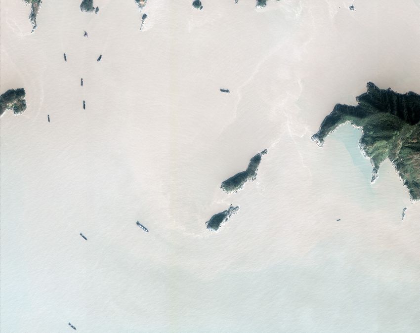
Methodology
For this paper, Project Sandstone relied on a variety of data sources, including Automatic Identification
System (AIS) data, high- and low-resolution electro-optical and Synthetic Aperture Radar (SAR) satellite
imagery, commercial vessel-build information and photographs of vessels from a variety of platforms.

Acknowledgements
RUSI and Project Sandstone would like to thank its partners, without which this work would not have
been possible. Windward’s platform greatly enhanced our ability to filter and detect anomalous AIS
signals, enabling us to extract, database and analyse these signals. The IHS SeaWeb platform allowed us to
cross-reference vessel details and identities against satellite imagery. Maxar Technologies helped Project
Sandstone source high-resolution satellite imagery, while Planet Labs also helped us find and extract high-
and low-resolution images of various vessels and locations of interest. As always, Polestar Space Applications
provided assistance and additional AIS data. We would also like to thank IntSight Global and a number of
others for comments, help and advice on this paper, including Tom Plant, Catherine Dill, Leo Byrne and
Malcolm Chalmers.
Executive Summary

A
        NEW INVESTIGATION reveals that a large fleet of North Korean cargo ships continues to deliver coal
        to China in contravention of UN Security Council (UNSC) resolutions, in what appears to be a large-
        scale, coordinated effort to evade sanctions imposed on North Korea over its nuclear weapons and
ballistic missile programmes.

Starting in January 2019, just days before the fourth Kim Jong-un and Xi Jinping summit in
Beijing,1 North Korean cargo ships began visiting waters around the Chinese islands of Zhoushan, often
while transmitting fake details over their Automatic Identification System (AIS) transponders, in violation of
international regulations designed to avoid accidents at sea.

The trend was first identified and made public in the UN Panel of Experts (PoE) 2019 interim report,2
which identified several North Korean vessels in satellite imagery in the waters off Zhoushan during
March and May 2019.

While China rejected these findings, stating that the evidence lacked ‘timeliness’ and suffered from
ambiguity,3 information collected and analysed for this report confirms that, not only do North Korean
vessels continue to visit this specific region, but they are doing so in unprecedented numbers.

Satellite imagery collected over North Korean ports and islands around Zhoushan confirms that these
vessels are loading coal and other resources,4 before sailing into Chinese waters where a combination of
lighters, barges and floating transloading platforms are likely offloading this coal for onward shipment to
Chinese terminals.5

This large-scale effort to evade UNSC resolutions is occurring only kilometres from one of China’s most
important naval facilities and the home of the East Sea Fleet, where a variety of destroyers, frigates,
corvettes and electronic surveillance ships are based.6 In addition, the islands are also home to a number
of facilities operated by the Chinese Coast Guard (CCG), the China Maritime Safety Administration (MSA)

1.   BBC News, ‘North Korea’s Kim Jong-un Visits China’s Xi Jinping’, 8 January 2019.
2.   UN Security Council (UNSC), ‘Report of the Panel of Experts Established Pursuant to Resolution 1874 (2009)’,
     S/2019/691, 30 August 2019, p. 14.
3.   Ibid., Annex 1, p. 38.
4.   Imagery provided by Planet Labs and Maxar Technologies.
5.   Satellite imagery provided by Planet Labs and Maxar Technologies for this report shows lighters close to North
     Korean vessels loaded with coal. Media reports indicate similar findings made by the UN Panel of Experts (PoE)
     in excerpts of an unreleased report according to Japan Times, ‘Illicit Imports to North Korea Continues, U.N.
     Experts Say’, 15 February 2020.
6.   Satellite imagery shows a constant military presence close to where North Korean ships loiter – in some cases,
     Chinese military vessels appear as close as 20 km to the areas where North Korean ships can be found. See
     Figures 24.
6                                                                                                      The Phantom Fleet

and the Zhoushan Port Authority – institutions tasked with enforcing various aspects of China’s maritime law
and which conduct regular patrols in the region.7

Despite this, North Korean vessels loaded with coal and other resources continue to sail to the area without
being stopped or detained by Chinese authorities,8 thereby likely enabling them to raise revenue for North
Korea’s nuclear and ballistic missile programmes in violation of UNSC resolutions.9

7.   AIS data provided by Windward shows regular patrols of vessels classified as ‘military’ or ‘law enforcement’ in
     the Zhoushan area.
8.   Satellite imagery acquired by the authors shows vessels loading coal, while their corresponding AIS signals then
     travel to Zhoushan.
9.   Coal is a commodity banned for export by UNSC resolutions. Other reports have shown how coal can be used
     to fund the North Korean nuclear and ballistic missile programme. See James Byrne et al., ‘Down and Out in
     Pyongyang and London: North Korea’s Coal Smuggling Networks Using UK Companies’, RUSI, Project Sandstone,
     Report 4, 26 September 2019.
Introduction

I
   N 2016, THE UN Security Council (UNSC) restricted North Korea’s exports of coal and other resources
   following Pyongyang’s nuclear and ballistic missile tests.10 Following additional weapons tests conducted
   by North Korea in 2017, the UNSC adopted Resolutions 2371 and 2397, which applied blanket bans on all
coal and iron ore exports from the country. UNSC Resolution 2397 also placed caps on the amount of crude oil
and petroleum products permitted for export to North Korea.11 Coal was one of the first commodities subject
to these measures as revenue generated from its export is used to fund North Korea’s WMD programme.12

Despite these resolutions, North Korea continues to export coal, iron ore and other resources to
foreign countries, employing a number of deceptive shipping practices to disguise these activities.13 For
example, after several North Korean vessels were identified visiting Chinese coal facilities in 2016 and
2017,14 most of the merchant fleet stopped openly transmitting identity and positional information over its
Automatic Identification Systems (AIS) transponders, making its trading patterns harder to track.

Despite these tactics, satellite photographs published in the 2019 UN Panel of Experts (PoE) report
showed that some North Korean cargo ships had abandoned their old trade routes and were conducting
ship-to-ship (STS) transfers with unidentified barges in Vietnamese waters.15 A report by the James Martin
Center for Nonproliferation Studies and RUSI detailed how one of these vessels – the 146-metre-long North
Korean-flagged Tae Yang – was using sophisticated AIS spoofing mechanisms to disguise its identity while
appearing on tracking platforms as a different, Singaporean-flagged vessel.16

However, the detention of the Wise Honest – a North Korean-flagged bulk carrier carrying coal – in Indonesian
waters in 2018, and its subsequent seizure by the US government,17 highlighted the risks that North Korean
vessels now faced as they sailed outside of the country’s territorial waters to deliver cargo.

10. UNSC, Resolution 2270 (2016), 2 March 2016.
11. UNSC, Resolution 2397 (2017), 22 December 2017.
12. In their 2019 submission to the 1718 Committee, the UN PoE reported that ‘[t]he nuclear and ballistic missile
    programmes of the Democratic People’s Republic of Korea remain intact and the country continues to defy
    Security Council resolutions through a massive increase in illegal ship-to-ship transfers of petroleum products
    and coal. These violations render the latest United Nations sanctions ineffective by flouting the caps on the
    import of petroleum products and crude oil by the Democratic People’s Republic of Korea as well as the coal
    ban, imposed in 2017 by the Security Council in response to the country’s unprecedented nuclear and ballistic
    missile testing’. See UNSC, ‘Report of the Panel of Experts Established Pursuant to Resolution 1874 (2009)’,
    S/2019/171, 5 March 2019, p. 4.
13. Catherine Dill et al., ‘On the Trail of the Tae Yang: AIS Spoofing and North Korean Coal Smuggling’, RUSI, Project
    Sandstone Report 3, 26 June 2019.
14. Leo Byrne, ‘North Korean Ship Arrives at Chinese Coal Terminal’, NK News, 16 December 2016.
15. UNSC, ‘Report of the Panel of Experts Established Pursuant to Resolution 1874 (2009)’, S/2019/171, 3 March
    2019, p. 21.
16. Dill et al., ‘On the Trail of the Tae Yang’.
17. Sarah N Lynch and Michelle Nichols, ‘US Seizes North Korean Ship it Accuses of Violating Sanctions’, Reuters, 9
    May 2019.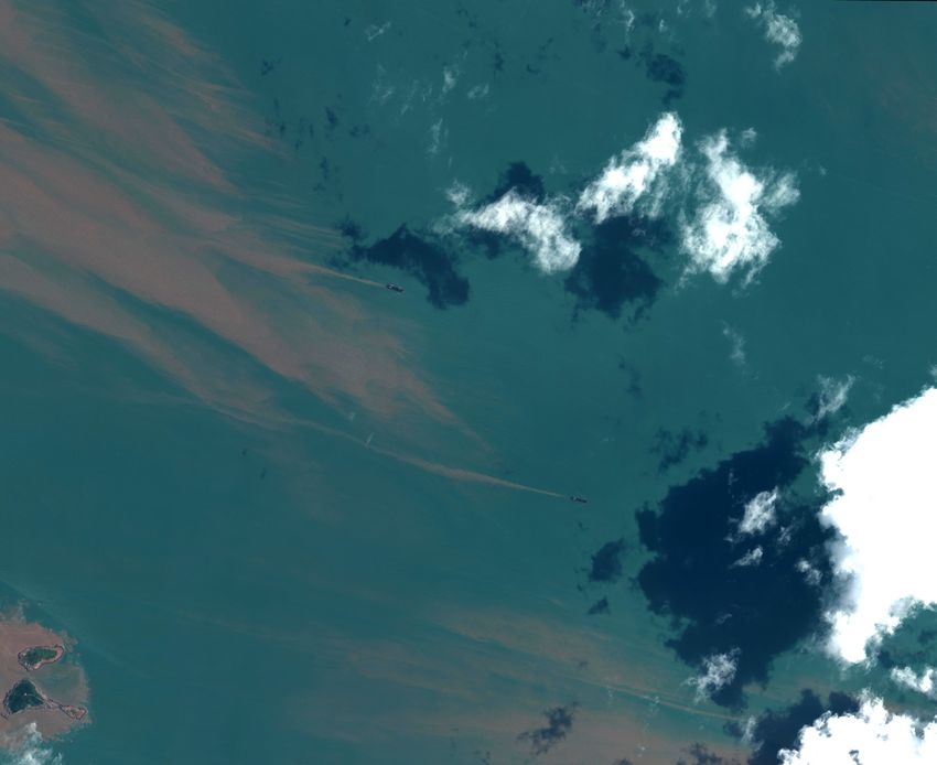
8                                                                                                   The Phantom Fleet

In 2019, North Korea’s evasion patterns changed again, as the country appeared to abandon the long,
extensive journeys to the Gulf of Tonkin for the seemingly relative safety of Chinese waters south of Shanghai
near the port of Zhoushan. In fact, multiple North Korean-flagged vessels previously identified as having
conducted STS transfers in the Gulf of Tonkin were observed by the authors in Zhoushan throughout 2019,
indicating a shift in the fleet’s area of operation. These include the Ho Chon Gang, Tae Yang, Ka Rim Chon,
Oriental Treasure, Jang Un and Asia Honor.18 The first evidence of North Korean ships visiting this area en
masse was made public in the interim 2019 UN PoE Report, which released satellite images showing several
vessels here conducting STS transfers.19

Analysis conducted for this report shows that a significant portion of North Korea’s cargo ships and
bulk handlers continues to visit the area, where it is most likely delivering coal and other resources
in contravention of UNSC resolutions.

18. See Figures 5, 8, 9 and 22.
19. UNSC, ‘Report of the Panel of Experts Established Pursuant to Resolution 1874 (2009)’, S/2019/691, 30 August
    2019, pp. 14–15.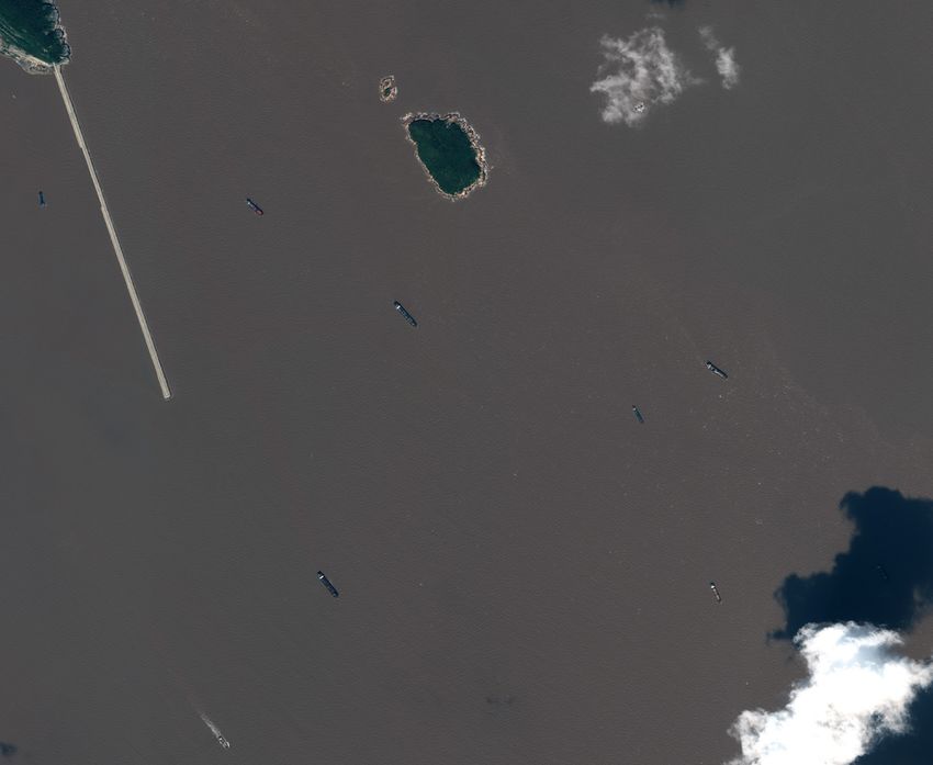
The Zhoushan Game Plan

O
       N 3 January 2019, only days before the fourth Xi Jinping and Kim Jong-un summit in Beijing, a North
       Korean vessel named the Ryon Hwa 2 – a ship once stopped by the US Navy en route to Myanmar
       suspected of carrying North Korean ballistic missile components20 – transmitted positional AIS signals
in the waters off Zhoushan.21

While it was unclear what the Ryon Hwa 2 was doing in Chinese waters, the vessel loitered in the area for six
days before disappearing from AIS tracking platforms until nearly a year later in December 2019. Following
this visit, a steady stream of North Korean vessels began visiting the area without calling into local ports or
bulk-handling facilities where they might have offloaded or taken on cargo.22

Imagery first released by the UN PoE in 2019 showed that some of these North Korean vessels were visiting
the area to unload coal – and potentially other sanctioned commodities – to Chinese barges and lighters at
sea in violation of UNSC resolutions.23 As in the case of North Korea’s efforts to import oil, transfers of cargo
at sea are harder to detect, making sanctions enforcement more difficult.

However, AIS data and satellite imagery collected for this report since early 2019 indicates that at least 30
North Korean-flagged, and North Korean-linked, vessels have conducted around 175 separate trips to the
area,24 often visiting the same regions and anchorages next to major bulk-handling facilities where barges
and other vessels designed to transfer cargo between vessels operate. According to information published in
August 2019 by the UN PoE, 127 shipments of North Korean coal were made in the first four months of 2019
alone, indicating that the data collected for this report has captured just a fraction of the total deliveries.25

The evidence presented here also suggests that the North Korean operation is well coordinated and centrally
directed, with vessels collectively visiting and loading commodities at North Korean ports before sailing in
convoy to the same areas in Zhoushan. In some instances, clusters of North Korean vessels were captured on
satellite imagery in Chinese territorial waters with their cargo bays open, indicating that they had delivered
commodities previously loaded in North Korean ports.26

These activities constitute a comprehensive breach of UNSC provisions designed to limit the country’s
nuclear weapons and ballistic missile programmes and appear to provide an open channel through which

20. David E Sanger, ‘U.S. Said to Turn Back North Korea Missile Shipment’, New York Times, 12 June 2011.
21. AIS data provided by Polestar Space Applications.
22. AIS data shows no records of these vessels calling into local Chinese ports or bulk-handling facilities, while port
    inspection records show that no North Korean vessels have been inspected in the area since 2016. This indicates
    that these bulk carriers and cargo ships were offloading cargo at sea, likely in STS transfers to other vessels.
23. UNSC, ‘Report of the Panel of Experts Established Pursuant to Resolution 1874 (2009)’, S/2019/691, 30 August
    2019, pp. 14–15.
24. Evidence compiled from AIS data, satellite imagery and openly available port records.
25. UNSC, ‘Report of the Panel of Experts Established Pursuant to Resolution 1874 (2009)’, S/2019/691, 30 August
    2019, p. 14.
26. Imagery provided by Planet Labs and Maxar Technologies.
10                                                                                        The Phantom Fleet

North Korea can export sanctioned commodities and potentially other illicit goods, thereby raising the
revenue necessary to continue with its nuclear and ballistic missile programmes.
Isolating Anomalous AIS Signals
I
N ORDER to identify possible North Korean vessels visiting the waters off Zhoushan, the authors first
looked for anomalous AIS signals in the area that had either also transmitted in North Korean waters
or appeared on a course into North Korean ports. Using this technique, dozens of separate signals were
identified and catalogued. In many instances, these transmissions included false or abbreviated vessel
names, fake International Maritime Organization (IMO) numbers and Maritime Mobile Service Identity
(MMSI) numbers associated with flag registries other than that of North Korea.27 In others, the reported
names and IMO numbers varied only slightly from their IMO-registered identities.
Figure 1: Example of AIS overlaid with imagery identifying the Oriental Treasure and the Tian Tong transmitting
fraudulent MMSI numbers and names
Vessel Name Fake AIS Identity
IMO MMSI FLAG NAME
9115028 620256000 COMOROS DONG FANG
ORIENTAL TREASURE IMO Registered Identity
IMO MMSI FLAG NAME
9115028 445058000 NORTH KOREA ORIENTAL TREASURE
Vessel Name Fake AIS Identity
IMO MMSI FLAG NAME
8712348 457304000 MONGOLIA AO
TIAN TONG IMO Registered Identity
IMO MMSI FLAG NAME
8712348 445598000 NORTH KOREA TIAN TONG
Source: Project Sandstone.
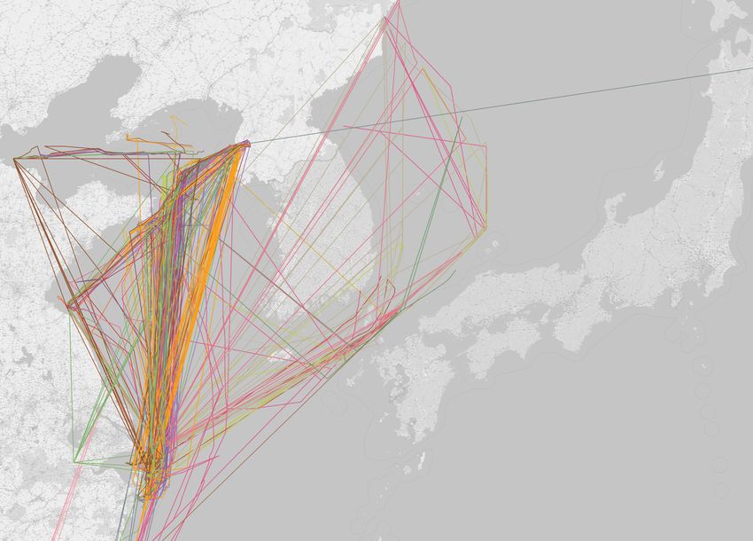
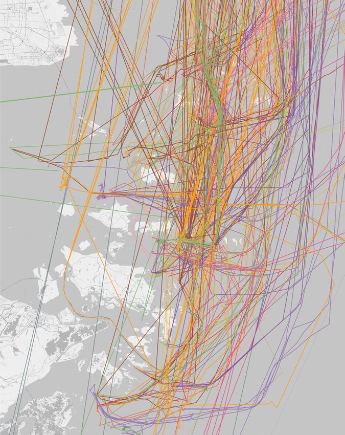
While dozens of North Korean vessels – and ships that transmitted AIS signals both in North Korea and
Zhoushan – visited these areas in China’s territorial waters, a heatmap generated from all their collated AIS
27. The International Maritime Organization (IMO) assigns vessels a unique identification number known as their
IMO number. Flag states, meanwhile, assign the vessel’s unique Maritime Mobile Service Identity (MMSI), which
acts as the number for the ship’s radio station. Vessels should transmit their correct IMO and MMSI numbers
over AIS transmissions, thereby identifying themselves and the flag under which they are sailing. In many of
the cases studied for this report, vessels were transmitting fake MMSI numbers and, sometimes, also fake IMO
numbers.12 The Phantom Fleet
data shows that most visible traffic clustered in a number of regions and anchorages off the Nandingxing
and Sankuai islands.28
The authors classified these into coordinate-bounded Areas of Interest (AOI) and assigned each a name
derived from nearby geographical areas and features.
• AOI 1 – SOUTH PORT.
• AOI 2 – DUCK HEAD.
• AOI 3 – YELLOW MOUNTAIN.
• AOI 4 – BACK ALLEY.
• AOI 5 – DONGYU HARBOUR.
• AOI 6 – CROWN POINT.
28. The heatmap was generated in GIS software and assigns intensity values to areas where the most AIS signals
were transmitted. It was created by collating all AIS data from North Korean-flagged vessels which had visited
Zhoushan, as well as spoofed AIS tracks which visited both North Korea and the Zhoushan area in 2019 and
2020.Byrne, Byrne, Somerville and Macdonald 13
Figure 2: Heatmap image with highlighted AOIs
Source: Project Sandstone.
High- and low-resolution electro-optical and Synthetic Aperture Radar (SAR) imagery was then collected
over these AOIs to identify ships visiting the region after loading coal or other cargo in North Korea. Vessels
identified in these images were then compared against Project Sandstone’s vessel image library, open source
and commercially available photos of North Korean vessels and ship build information from the IHS SeaWeb14 The Phantom Fleet
platform.29 Using this technique, it was possible to match anomalous AIS tracks to vessels and then verify
the identity of these vessels.30
In the majority of cases assessed for this report, these were ultimately North Korean-flagged cargo ships or
bulk carriers that appeared to sail to the region after visiting North Korea’s largest port of Nampo, or other
cargo berths along the Taedong River, designed for loading coal or other commodities.31 In some instances,
the vessels identified in other areas were oil tankers that had no registered flag on official databases, but
which appeared to visit North Korean ports and oil terminals after loitering in Chinese waters. In a number
of instances, the authors were unable to identify the vessels owing to a lack of distinguishing features or an
absence of commercial or historical satellite imagery, or a combination of these factors. In a subset of these,
however, vessels observed in Chinese waters transmitting on fake AIS profiles were also observed in North
Korea, indicating these were either North Korean vessels or others that loaded cargo in North Korea.
In total, over 30 different North Korean vessels were identified visiting the region, including a number of
UNSC designated vessels and some of the country’s largest bulk carriers and cargo vessels.32
29. For more details on vessel identification details and methodology, see IHS Seaweb,
and Annex 1.
30. Vessels captured in high-resolution imagery were measured in GIS software for length, breadth and other
structural features such as length and width of cargo bays, hatches and other measurements contained in build
information published by IHS SeaWeb. The authors also checked whether identified ships had sister ships which
could confound identification, eliminating these as candidates with other open-source data such as AIS tracks.
31. Satellite imagery provided by Planet Labs and Maxar Technologies.
32. Together, these ships accounted for a significant proportion of the country‘s bulk carrier and cargo fleet, a fact
which demonstrates the importance of this trade for North Korea‘s economy and ability to generate revenue
from the sale of resources abroad.Figure 3: Collated AIS Data, North Korea and Zhoushan, China, 2019–20
15
Byrne, Byrne, Somerville and Macdonald
Source: Project Sandstone.The Shanghai Express
L
OCATED JUST southeast of Shanghai, the Zhoushan islands in Zhejiang province are some of China’s
busiest waterways and are home to a wide variety of commercial and military facilities.33 To sail
here from Nampo, North Korean vessels must enter some of the world’s busiest shipping lanes off
the Chinese coast, where sailing without AIS can be dangerous. This is particularly true in the waters off
Zhoushan, where fog and adverse weather conditions can make sailing perilous.34 As a result, North Korean
vessels sailing past Shanghai to the region often appear to transmit AIS signals, likely as a safety measure to
avoid accidents and collisions.
In several instances assessed for this report, AIS data and imagery collected over North Korea and Zhoushan
showed clusters of ships appearing to travel in concert after loading coal in North Korean ports.
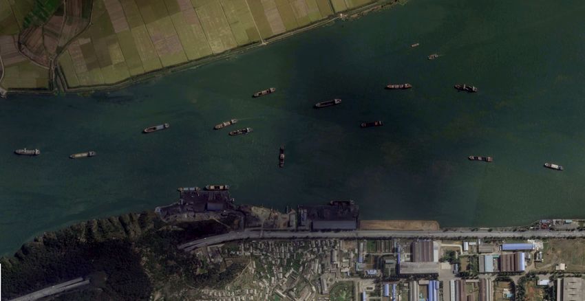
October 2019: AOI 3 (YELLOW MOUNTAIN)
On 3 and 6 October 2019, high-resolution imagery collected by Planet Labs shows over a dozen bulk carriers
and cargo vessels at berths in Taean and Songnim, both North Korean ports along the Taedong River.35
Several of these vessels appear to be loading coal and other resources, while others have their cargo bays
open after having taken on coal.
33. Katherine Si, ‘Ningbo-Zhoushan Posts Cargo Volume of 1.12bn tonnes in 2019’, SeaTrade Maritime News, 16
January 2020, , accessed 19 February 2020. See also Global Security.org, ‘Zhoushan Naval Base‘, , accessed 19 February 2020.
34. Liberia Maritime Authority, ‘Marine Advisory: 04/2017 – Precautions when Navigating Waters in and Around
Ningbo-Zhoushan, China’, 25 May 2017, , accessed 24 February 2020.
35. There are a number of ports, berths and terminals along the Taedong River, which runs through Pyongyang,
through Nampo and out into the Yellow Sea.Figure 4: Cluster of North Korean ships in Taean with some vessels loading coal, 3 October 2019
17
Byrne, Byrne, Somerville and Macdonald
Source: Imagery by Planet Labs. Annotated by Project Sandstone.The Phantom Fleet
Figure 5: The Oriental Treasure in Taean, North Korea, 3 October 2019
Source: Imagery by Planet Labs. Annotated by Project Sandstone.
18Byrne, Byrne, Somerville and Macdonald 19
Figure 6: The Tae Yang loading coal in Songnim, 5 October 2019
Source: Imagery by Planet Labs. Annotated by Project Sandstone.
On 5 October, SAR data collected by the EU’s Sentinel 1 satellites shows a large clustering of over 20 vessels
outside Nampo’s West Sea Barrage (WSB).20 The Phantom Fleet
Figure 7: SAR image taken over Nampo, North Korea, 5 October, showing large cluster of vessels possibly ready
to sail together
©
Source: Imagery by Copernicus Open Access Hub. Annotated by Project Sandstone.
Less than 10 days later, imagery shot over AOI 3 (YELLOW MOUNTAIN) shows six bulk carriers and cargo
vessels anchored in the area, in the proximity of a 55-metre long floating transfer terminal – a piece of
equipment designed for transloading ore and minerals between vessels.36 Within the satellite imagery
obtained, four of these vessels are sitting low in the water and appear fully laden, while two are sitting
higher in the water and may already have unloaded.
An analysis of the lengths, breadths, superstructures, configurations and paint schemes of these vessels
confirms these are the New Dawn, Tae Yang, Oriental Treasure, Tian Tong, Kum Gang San 2 and the Ka Rim
Chon.37 All of these ships are North Korean-flagged, while a number have previously been identified as
involved in North Korea’s efforts to export coal in violation of UNSC resolutions.38 As highlighted in figures
36. The equipment identified in the image was highly similar to cranes shown on Shipspotting.com. See
Shipspotting.com, ‘GANGWAN 3 HAO’, 6 June 2014, , accessed 2 March 2020.
37. New Dawn, IMO: 9135494; Tae Yang, IMO: 8306929; Oriental Treasure, IMO: 9115028; Tian Tong, IMO:
8712348; Kum Gang San 2, IMO: 9050967; and Ka Rim Chon, IMO: 8314811.
38. UNSC, ‘Final Report of the Panel of Experts Submitted Pursuant to Resolution 2407 (2018)’, 5 March 2019,
p. 121. The Oriental Treasure was imaged as a vessel loading coal in Nampo and then conducting STS transfersByrne, Byrne, Somerville and Macdonald 21
above, several of these ships were captured on satellite imagery loading coal in North Korea immediately
prior to their arrival in Zhoushan.
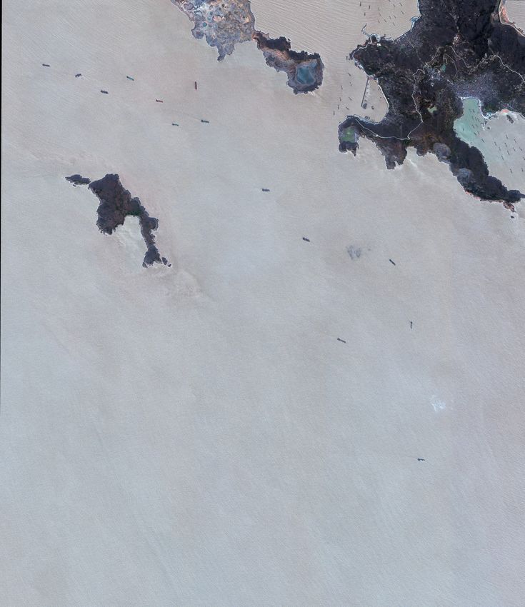
Figure 8: Cluster of North Korean vessels at AOI 3 (YELLOW MOUNTAIN), 14 October 2019, 02:56 UTC
©
Source: Imagery by Maxar Technologies. Annotated by Project Sandstone.
January 2020 – AOI 1 (SOUTH PORT)
On 31 January 2020, high-resolution satellite imagery taken over AOI 1 (SOUTH PORT) at 10:57 local time
(UTC+8) shows a large concentration of North Korean vessels anchored in close proximity to one another.
On this day, eight vessels in this area were transmitting on fake AIS profiles, likely in an attempt to obscure
their identity.
in the Gulf of Tonkin in 2018. The Tae Yang and Ka Rim Chon were also named in the 2019 interim report as
vessels recommended by the Panel for designation by the UNSC.22 The Phantom Fleet
Figure 9: Cluster of North Korean vessels at AOI 1 (SOUTH PORT), 31 January 2020
© 2020 Maxar Technologies
Source: Imagery by Maxar Technologies. Annotated by Project Sandstone.Byrne, Byrne, Somerville and Macdonald 23
Six of these vessels present in the image (Figure 9) are officially North Korean-flagged and include the Ever
Glory, Tian Tong, Jisong 15, New Dawn, Ho Chon Gang and Un Ha.39 One of these, the Yildirimlar 1, operates
out of Nampo but is listed in official records as flying an unknown flag.40 Two unidentified vessels in the
same image have also been captured on satellite imagery in Nampo, indicating they are likely also North
Korean vessels. In addition to this group, an unidentified lighter can be seen in the image in close proximity
to these vessels.
At 17:54 local time (UTC+8), seven hours after this high-resolution image was taken, the Copernicus
Sentinel-1 satellite captured a low-resolution SAR image41 of the area that shows the same number of ships
in the same configuration, with the exception of one noteworthy anomaly.
By comparing the high-resolution and SAR images, it is apparent that the unidentified lighter has moved and
is no longer in the same position. What is also apparent in the SAR image is that in the position previously
occupied by the Jisong 15, there now appear to be two vessels seen side-by-side in a configuration consistent
with an STS. While Sentinel 1 SAR imagery cannot be used to identify the vessel ostensibly next to the Jisong
15, it does indicate there is a similarly sized ship at its side.
Figure 10: High-resolution satellite imagery taken at 02:57 UTC compared with SAR imagery taken 7 hours later
at 09:54 UTC showing a possible STS transfer taking place
©
©
Source: Imagery by Copernicus Open Access Hub and Maxar Technologies. Annotated by Project Sandstone.
High-resolution optical images are typically taken by sun-synchronous satellites between 10:00 and 14:00
locally (UTC+8), in order to take advantage of optimal light conditions. Throughout the course of this
research, it became apparent that North Korean-flagged vessels were potentially offloading coal and other
39. Ever Glory, IMO: 8909915; Ji Song 15, IMO: 9004671; Tian Tong, IMO: 8712348; New Dawn, IMO: 9135494; Ho
Chon Gang, IMO: 8415287; and Un Ha, IMO: 8310281.
40. Yildirimlar-1, IMO: 8031407. See IMO GISIS Database, , accessed 2 March 2020.
41. Copernicus Open Access Hub, , accessed 1 February 2020.24 The Phantom Fleet
resources outside of these hours to avoid being captured on imagery. However, the SAR image – taken hours
after the high-resolution satellites had passed – potentially shows how this offloading may be taking place.
All six of the aforementioned vessels continued to transmit false AIS data the day after, on 1 February 2020.42
On this date, a Chinese Coast Guard (CCG) vessel – the HAI XUN 0743 – conducted a patrol through the
anchorage, passing within hundreds of metres of the vessels transmitting on fraudulent AIS identifiers.43
Despite UNSC resolutions – as well as Chinese directives on AIS transmissions – the vessels do not appear to
have been stopped, inspected or detained.44
Two hours after the patrol, the track of another North Korean vessel – the E Morning – transmitting on a fake
AIS signal sailed into the anchorage.45
September 2019 – AOI 2 (DUCK HEAD)
On 25 September 2019, high-resolution satellite imagery taken over AOI 2 (DUCK HEAD) shows the North
Korean-flagged Oriental Treasure and Yon Moo46 anchored and potentially laden.47 The Yon Moo has its
cargo bays open with what appears to be coal in the hold. At a nearby anchorage to the northeast, an
unidentified lighter can be seen, also with its cargo bays open.
42. See Annex 1.
43. For more information on this, see this report’s section on ‘Hiding in Plain Sight’, pp. 40–45.
44. Tokyo Memorandum of Understanding (MoU), , accessed 5 February 2020.
45. AIS data provided by Polestar Space applications shows the E Morning transmitting on the false AIS identity with
the name ‘548433000‘. This AIS track was matched by satellite imagery to the E Morning. On 1 February 2020,
this AIS track enters AOI 1 (SOUTH PORT), then appears to turn off its AIS transponder.
46. Oriental Treasure, IMO: 9115028; Yon Moo, IMO: 9003653.
47. The Yon Moo was previously named the Forever Lucky and was imaged loading coal in Nampo in December
2017. This imagery was released by the UN PoE in 2019. See UNSC, ‘Report of the Panel of Experts Established
Pursuant to Resolution 1874 (2009)’, S/2019/171, 3 March 2019, p. 20.Byrne, Byrne, Somerville and Macdonald 25
Figure 11: Oriental Treasure and Yon Moo at AOI 2 (DUCK HEAD), 25 September 2019
©
Source: Imagery by Maxar Technologies. Annotated by Project Sandstone.
One day later, on 26 September 2019, high-resolution satellite imagery taken over the same area shows
that both the Oriental Treasure and Yon Moo have departed and been replaced by the North Korean-
flagged E Morning.48
48. E Morning, IMO: 8717910.26 The Phantom Fleet
Figure 12: The E Morning at AOI 2 (DUCK HEAD), 26 September 2019
©
Source: Raw imagery by Maxar Technologies. Annotated by Project Sandstone.
November 2019 – AOI 2 (DUCK HEAD)
On 11 November 2019, imagery over AOI 2 (DUCK HEAD) shows the North Korean-flagged Jang Un49 at the
same anchorage as previously visited by the Oriental Treasure and Yon Moo. Anchored nearby is a lighter
and four large floating cranes designed to move cargo between vessels.50 The ship was also identified in a
March 2019 advisory issued by the US Treasury as a vessel believed to have conducted STS transfers of coal.51
49. Jang Un, IMO: 8822260.
50. UNSC, ‘Final Report of the Panel of Experts Submitted Pursuant to Resolution 2407 (2018)’, 5 March 2019,
p. 120.
51. US Department of the Treasury, ‘Updated Guidance on Addressing North Korea’s Illicit Shipping Practices’, North
Korea Sanctions Advisory, 21 March 2019, , accessed 3 March 2020.Byrne, Byrne, Somerville and Macdonald 27
Figure 13: Jang Un at AOI 2 (DUCK HEAD), 11 November 2019
©
Source: Imagery by Maxar Technologies. Annotated by Project Sandstone.
December 2019 – AOI 2 (DUCK HEAD)
A month later, on 14 December 2019, several North Korean vessels can be seen in high-resolution imagery
of DUCK HEAD, including the North Korean-flagged So Baek Su,52 the Yon Moo and an unidentified vessel
that has transmitted AIS in North Korea. Immediately nearby is a collection of lighters and floating cranes.
52. So Baek So, IMO: 8817289.The Phantom Fleet
Figure 14: The So Baek Su and the Yon Moo at AOI 2 (DUCK HEAD), 14 December 2019
©
Source: Imagery by Maxar Technologies. Annotated by Project Sandstone.
28Byrne, Byrne, Somerville and Macdonald 29
July 2019 – AOI 4 (BACK ALLEY)
On 24 July 2019, high-resolution imagery shows two of North Korea’s largest bulk carriers, the
UNSC-designated Ryong Rim53 and the North Korean-flagged Myong Sin,54 anchored at AOI 4 (BACK ALLEY).55
The Ryong Rim was designated by the UNSC in 2016 as an economic resource of Ocean Maritime Management
(OMM) – itself a UNSC designated entity.56 OMM vessels were designated under Resolution 2270 in 2016
pursuant to Paragraph 8(d) of Resolution 1718, thereby identifying them as assets that are owned or
controlled by actors within North Korea’s programmes relating to nuclear weapons, other weapons of mass
destruction and ballistic missiles.57
The second vessel at AOI 4 on 24 July was the North-Korean flagged Myong Sin, a vessel previously
identified by the UN PoE as having moved coal on behalf of the North Korean military in 2016.58 The
shipments were linked to the UNSC-sanctioned company Korea Kangbong Trading Corporation, an entity
subordinate to the Ministry of People’s Armed Forces.59 In addition to this, the UN PoE revealed in its
2017 report that the Myong Sin – formerly called the Bright Star – has ties to OMM-linked networks.60
In the image taken on 24 July 2019, both vessels are anchored in close proximity to a bulk-handling facility,
which appears to handle iron ore.61 The Ryong Rim is sitting high in the water and has its cargo bays open,
indicating it has unloaded cargo.
Other UNSC-designated vessels have transmitted AIS signals in the region. For example, the UNSC-designated
OMM vessels – the Ryo Myong62 and the Chong Bong63 – broadcast their AIS signals within Chinese waters in
the Zhoushan area in 2019.64 The Ryo Myong broadcast its signal in Zhoushan in September 2019, while the
Chong Bong broadcast its AIS signal on 8 August 2019, just 19 days after being captured in satellite imagery
53. Ryong Rim, IMO: 8018912.
54. Myong Sin, IMO: 9045182.
55. For vessel identification methodology, see Annex 1.
56. UNSC, Resolution 2270 (2016), 2 March 2016.
57. Ibid.
58. UNSC, ‘Report of the Panel of Experts Established Pursuant to Resolution 1874 (2009)’, S/2017/150, 27 February
2017, p. 142.
59. UNSC, 1718 Sanctions List, ‘KPe.043’, p. 14, , accessed 3 February 2020.
60. UNSC, ‘Report of the Panel of Experts Established Pursuant to Resolution 1874 (2009)’, S/2017/150, 27 February
2017, p. 142.
61. See IHS SeaWeb, , accessed 10 February 2020.
62. Ryo Myong, IMO Number: 8987333.
63. Chong Bong, IMO Number: 8909575.
64. AIS data provided by Polestar Space Applications.30 The Phantom Fleet
loading coal at the North Korean port of Chongjin on 20 July 2019.65 Both vessels are also designated
pursuant to Paragraph 8(d) of Resolution 1718.66
Paragraph 9 of UNSC Resolution 2397 requires member states to ‘seize, inspect, and freeze (impound)
any vessel in their ports’ and empowers them to ‘seize, inspect, and freeze (impound) any vessel’ in their
territorial waters provided there are reasonable grounds to believe the vessel was engaged in illicit activity
prohibited by all UNSC resolutions.67 Paragraph 15 of the same resolution also decides that member states
with information regarding vessels designated under Paragraph 8(d) of UNSC Resolution 1718 within its
waters should notify the 1718 Committee of this information and the measures it took to inspect, freeze
and impound the vessel or ‘other appropriate actions’ per all UNSC resolutions pertaining to North Korea.68
Figure 15: Ryong Rim and Myong Sin at AOI 4 (BACK ALLEY), 24 July 2019
©
Source: Imagery by Maxar Technologies. Annotated by Project Sandstone.
65. Planet Labs imagery taken on 20 July 2019.
66. UNSC, Resolution 1718 (2006).
67. UNSC, Resolution 2397 (2017).
68. Ibid.Byrne, Byrne, Somerville and Macdonald 31
Imagery released by the UN PoE in 2019 shows another North Korean ship, the Jang Jin Gang, preparing for an
STS at these same coordinates in May that year. This confirms this is a region where North Korean vessels have
unloaded cargo.69
Satellite imagery collected a month earlier on 23 June 2019 shows the Ryong Rim anchored in Songnim,
North Korea close to a coal berth with its cargo bays open.70 Two days later, low-resolution imagery collected
by Planet Labs shows the Ryong Rim loading cargo at the Songnim coal berth.71
Figure 16: (Left) Ryong Rim empty in North Korea, 23 June 2019; (right) the Ryong Rim loading coal at Songnim
Terminal, 25 June 2019
Source: Imagery by Planet Labs. Annotated by Project Sandstone.
August 2019 – AOI 6 (CROWN POINT)
On 2 July 2019, the North Korean-flagged cargo vessels Kum Song 372 and Ever Glory73 were observed on
high-resolution imagery leaving North Korea as they exited the WSB outside Nampo on the same day. In this
instance, the Ever Glory was transmitting on a fake AIS signal and using a Nigerian MMSI number,74 while the
Kum Song 3 was ostensibly not transmitting an AIS signal.
69. UNSC, ‘Report of the Panel of Experts Established Pursuant to Resolution 1874 (2009)’, S/2019/691, 30 August
2019, pp. 14–15.
70. Imagery provided by Maxar Technologies.
71. Imagery provided by Planet Labs.
72. Kum Song 3, IMO: 8661850.
73. Ever Glory, IMO: 8909915.
74. AIS data provided by Polestar Space Applications.32 The Phantom Fleet
Figure 17: Ever Glory and Kum Song 3 leaving Nampo, 2 July 2019
©
Source: Imagery by Maxar Technologies. Annotated by Project Sandstone.
On 1 August 2019, west of AOI 6 (CROWN POINT), both the Kum Song 3 and Ever Glory were captured on
high-resolution imagery while anchored in Chinese waters with their cargo bays open and what appears to
be coal in their holds.Byrne, Byrne, Somerville and Macdonald 33
Figure 18: Kum Song 3 and Ever Glory near AOI 6 (CROWN POINT), 1 August 2019
©
Source: Imagery by Maxar Technologies. Annotated by Project Sandstone.
Eleven days later, on 12 August 2019, another two North Korean-flagged vessels, the K Morning75 and the
Ho Chon Gang,76 were captured on high-resolution imagery anchored in the same area near AOI 6 (CROWN
POINT). Although both the K Morning and Ho Chon Gang were not transmitting on AIS at this time, the
K Morning transmitted its IMO-registered identity over its AIS transponder at these exact same coordinates
in October 2019.
75. K Morning, IMO: 9021576.
76. Ho Chon Gang, IMO: 8415287.The Phantom Fleet
Figure 19: K Morning and Ho Chon Gang near AOI 6 (CROWN POINT), 12 August 2019
© 2020 Maxar Technologies
Source: Imagery by Maxar Technologies. Annotated by Project Sandstone.
34New Ships on the Block
R
ESEARCH FOR this report also reveals that North Korea appears to have acquired two large new bulk
carriers, potentially filling a capacity gap created following the interdiction of the Wise Honest by
Indonesia in May 2018.77
Despite UNSC resolutions prohibiting the practice,78 one of the ships – previously called the Great Wenshan79
– appears to have been acquired and re-flagged by North Korea and later renamed the Tae Pyong in 2020.80
The now-renamed Tae Pyong broadcast its AIS from North Korean waters in Nampo on 6 January 2020.81
A high-resolution image captured by Maxar Technologies on 24 January 2020 over Nampo, North Korea,
confirms this is the formerly named Great Wenshan.
77. Eileen Sullivan and Benjamin Wiser, ‘US Seizes North Korean Ship for Violating Sanctions’, New York Times, 9
May 2019.
78. UNSC, Resolution 2321 (2016), para. 9; UNSC, Resolution 2397 (2017), para. 14.
79. Now named the Tae Pyong, IMO: 9018751.
80. IHS Seaweb, , accessed 2 March 2020.
81. Polestar Space Applications.36 The Phantom Fleet
Figure 20: The Tae Pyong in Nampo, 24 January 2020
©
Source: Imagery by Maxar Technologies. Annotated by Project Sandstone.
In addition to this, at some point in 2019, a ship called the Fu Xing82 had its name changed to the Pu Zhou.83
While it did not re-flag to North Korea, the Pu Zhou did exhibit other traits common to North Korean vessels
engaged in illicit activity.
The Pu Zhou broadcast AIS transmissions at a dry dock in Zhoushan on 19 June 2019, when it also changed its
MMSI number.84 Following that, on 4 August 2019, the vessel left the dry dock and loitered in Zhoushan until
14 August when it dropped its AIS signal.85 It was next seen on 18 August in North Korean waters heading on a
course towards the WSB and Nampo.86
On 1 September 2019, maritime databases show the Pu Zhou leaving the Sierra Leone flag
registry without obtaining a replacement flag of convenience.87 In October 2019, the Pu
Zhou transmitted AIS signals from Nampo on a different MMSI number. Low-resolution
82. Pu Zhou, IMO: 8605727.
83. IHS Seaweb, , accessed 2 March 2020.
84. Windward platform indicates MMSI change.
85. Ibid.
86. Ibid.
87. Ibid.Byrne, Byrne, Somerville and Macdonald 37
imagery from Planet Labs confirms the vessel was present in Nampo at this time.88
In addition, the ship was observed loading coal at the North Korean port of Songnim on 4 November 2019.89
The vessel then left North Korea on 9 November 2019 and travelled down the Chinese coast past Zhoushan.
On 12 November, the Pu Zhou began transmitting under a different and non-existent IMO number,90 before
turning round and returning to Zhoushan at AOI 2 (DUCK HEAD), where it stayed from 15 to 25 of November
2019.91 Subsequent to this visit to AOI 2, the Pu Zhou returned to Nampo on 1 December 2019.92
Figure 21: The Pu Zhou loading coal in Nampo and sailing to AOI 2 (DUCK HEAD), 16 November 2019
©
Source: Imagery by Planet Labs, Google Earth and Maxar Technologies. Annotated by Project Sandstone.
88. Windward platform indicates MMSI change; Planet Labs provided imagery of Nampo.
89. High-resolution 0.8-metre satellite imagery provided by Planet Labs.
90. Windward.
91. 3-metre satellite imagery provided by Planet Labs shows the Pu Zhou at DUCK HEAD in Zhoushan with its cargo
bays open.
92. AIS tracked with Windward supported by imagery from Planet Labs.Transhipment Chains
E
VIDENCE PRESENTED by the UN PoE in 2019 showed that a number of North Korean vessels were
conducting STS transfer operations with lighters and barges in the region in contravention of UNSC
resolutions. The Panel recommended that port authorities should engage in higher scrutiny of lighters
given their use in conducting STS transfers of coal with North Korean-linked vessels as established by
Paragraph 9 of UNSC Resolution 2397.93
However, as highlighted above, several satellite images collected for this report show floating transloading
platforms, cranes and lighters anchored and active in several of the AOIs where North Korean ships were
visiting after loading coal in berths along the Taedong River. Some of the images collected and presented in
this report also show North Korean vessels in the region with their cargo bays open and what appears to be
coal in their holds. The region is also home to several large bulk-handling facilities that appear to be used
specifically for processing coal and iron ore. In some instances, these are even visible in the vicinity of North
Korean ships presented in this report.
In one instance, a high-resolution image taken on 10 May 2019 north of AOI 1 (SOUTH PORT) shows the
North Korean-flagged Asia Honor94 flanked by two unidentified lighters or barges with a floating transloading
platform also nearby. The Asia Honor was previously pictured conducting an STS with unidentified lighters in
the Gulf of Tonkin in February 2019.95
93. UNSC, Resolution 2397 (2017), 22 December 2017.
94. Asia Honor, IMO: 8405220.
95. UNSC, ‘Report of the Panel of Experts Established Pursuant to Resolution 1874 (2009)’, S/2019/691, 30 August
2019, p. 16.Byrne, Byrne, Somerville and Macdonald 39
Figure 22: The Asia Honor north of AOI 1 (SOUTH PORT), 10 May 2019
North of AOI 1, SOUTH PORT
Zhoushan, China, 10 May 2019
© 2020 Maxar Technologies
Source: Imagery by Maxar Technologies. Annotated by Project Sandstone.
However, evidence collected during the course of this report suggests that multiple barges and lighters
continue to be observed in the immediate vicinity of North Korean vessels. In some of these instances,
barges could be observed sailing towards North Korean vessels before dropping AIS signals, only to appear
back on tracking systems days later before sailing back to bulk-handling facilities along the Yangtze River.
For example, in one instance on 14 October 2019 – the same day during which multiple North Korean vessels
were anchored at AOI 3 (YELLOW MOUNTAIN) – a Chinese-flagged vessel named the Wei Ji 9 sailed to the
area before dropping its AIS signal.96 The vessel returned transmitting on 17 October before heading to
AOI2 (DUCK HEAD) on 18 October where a day before at least three vessels associated with North Korea
were transmitting false identities. The ship did not transmit for three days, before it began its return journey
upriver to a coal-handling facility in Sanzhewei.97
96. AIS data provided by Windward.
97. Maritime intelligence provided by Windward.40 The Phantom Fleet
Figure 23: Journey of the Wei Ji 9, October 2019
Source: Imagery by Windward. Annotated by Project Sandstone.
On 26 December 2019, the Wei Ji 9 once again sailed down to AOI 2 (DUCK HEAD), where it dropped AIS
signal for nearly two days. At this time, several North Korean ships were visiting the same AOI.Hiding in Plain Sight
T
HESE ILLICIT activities are occurring only kilometres away from one of China’s largest naval bases
and the home of the East Sea Fleet of the People’s Liberation Army Navy (PLAN), a fact which raises
significant questions about both Beijing’s implementation of UNSC resolutions and its response to
investigations conducted by the UN PoE.
Figure 24: Locations of Chinese military and other patrol facilities in Zhoushan
©
©
©
©
©
©
©
Source: Imagery by CNES, Maxar and Google Earth. Annotated by Sandstone.
Analysis of open source imagery confirms that a wide range of military vessels are present at these bases,
including destroyers, frigates, corvettes and electronic surveillance ships as well as smaller vessels which
regularly patrol the waters of Zhoushan.98
98. Imagery provided by Digital Globe, SentinelHub through Google Earth.42 The Phantom Fleet
Given the region’s strategic importance, the area and its surrounding islands are also host to a number of
possible coastal surveillance and radar facilities, likely designed to provide detection capabilities to the
PLAN and the authorities.
Figure 25: Possible radar and communication facilities in Zhoushan, China
©
©
©
©
©
©
Source: Imagery by Google Earth. Annotated by Project Sandstone.
In addition to the PLAN, other maritime enforcement agencies present in the Zhoushan area include the
CCG, China Maritime Safety Administration (MSA) and the Zhoushan Harbour and Port Administration.
These agencies conduct patrols in the region and are responsible for enforcing China’s maritime laws.
Regulations published by China’s Ministry of Transportation state that, in accordance with the International
Convention for the Safety of Life at Sea (SOLAS Convention) and the International Ship and Port Facility
Security Code (ISPS), ships in Chinese territorial waters must transmit their identity and positional data over
their AIS transponders.99
99. 中华人民共和国交通部 [Ministry of Transport of the People’s Republic of China], ‘中华人民共和国国际船舶保
安规则‘ [‘International Shipping Safety Rules and Regulations of the People‘s Republic of China‘], 28 April 2007,Byrne, Byrne, Somerville and Macdonald 43
The port of Zhoushan administers a large area of territory that encompasses several of the AOIs identified
above, including AOI 1, AOI 2, AOI 3 and AOI 6.100 Vessels entering the port must notify the authorities
prior to arrival and submit a number of different documents such as general and cargo declarations, crew
lists, passports, ship certificates, previous port visits and a variety of other different forms.101 Ships are also
tracked by Zhoushan Vessel Traffic Services (VTS) on radar and AIS, which also provides services to vessels
such as the provision of traffic, weather and navigational information.102
Furthermore, according to Chinese maritime safety regulations, a ship in China’s territorial waters is liable
to be inspected by the MSA to check the validity of its International Ship Security Certificate, ensure the
implementation of the ship’s safety measures, verify that it is keeping a ‘continuous summary record’ and
confirm the ship’s permanent identification number and its AIS. Inspections are compulsory for foreign-
flagged ships entering Chinese ports.103
Despite this, North Korean vessels transmitting false AIS data or sailing in the region without transmitting
AIS signals do not appear to have been stopped or detained by the Chinese authorities.104 Port inspection
records for Zhoushan do not record any inspections or detentions of the vessels identified in the region, or
any North Korean-flagged vessels since 2016.
According to port state control inspection data, the number of North Korean vessels being inspected
by port authorities in mainland China has decreased sharply since June 2017.105 Before 2018, North
Korean-flagged ships were reportedly inspected in a variety of ports in China, but since then all but seven
reported inspections were carried out in Dalian out of a total of 74 inspections.106 In fact, since 2015, only
two North Korean-flagged vessels have been reportedly inspected by the Zhoushan port authorities, taking
place in 2015 and 2016.107 This is despite the notable presence of North Korean-flagged ships appearing in
Zhoushan throughout 2019 and 2020.
, accessed 24 February 2020.
100. See IHS SeaWeb, Zhoushan Port, , accessed 1 March 2020.
101. Ibid.
102. Ibid.
103. Ibid.
104. See Tokyo MoU, , accessed 1 March 2020.
105. Ibid.
106. Ibid.
107. Ibid.You can also read