The use of Remotely Piloted Aircraft Systems (RPAS) - Copernicus
←
→
Page content transcription
If your browser does not render page correctly, please read the page content below
EENA / DJI Pilot Project Report

The use of Remotely Piloted Aircraft Systems (RPAS)
             by the emergency services
      A Report from the joint EENA and DJI Pilot Project

                                                                     1
                      EENA / DJI Pilot Project Report
                 European Emergency Number Association – EENA 112
                    Avenue de la Toison d’Or 79, Brussels, Belgium
                          +32/2.534.97.89 ǀ info@eena.org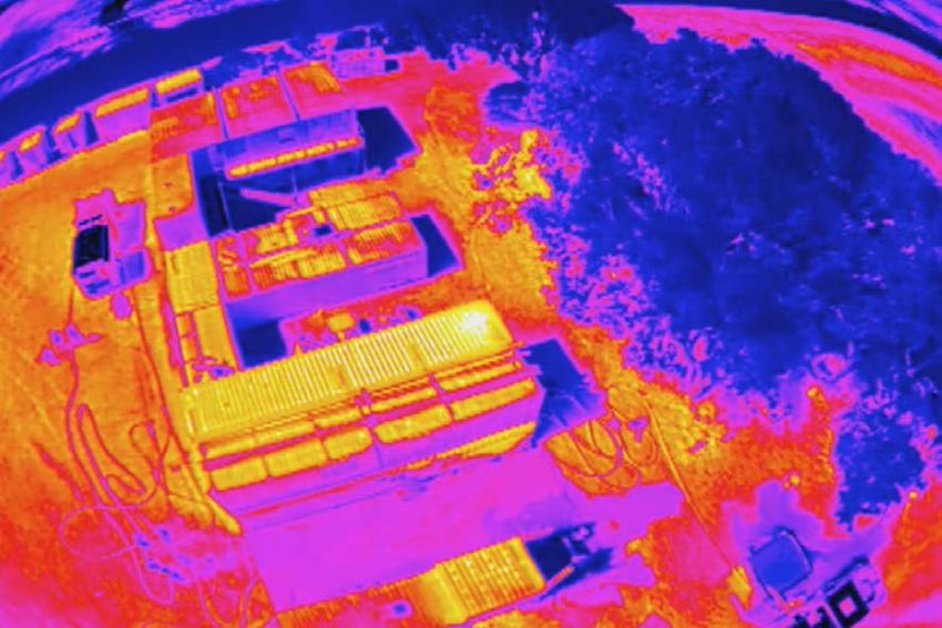
The use of Remotely Piloted Aircraft Systems (RPAS) by the emergency
Title
                    services; A Report from the joint EENA and DJI Pilot Project
Version             1.0
Revision date       2-11-2016
Status                                          Draft                              Approved

                          Authors and contributors to this document

        This document was written by EENA and DJI with contributions from the 4 Pilot Test sites:

                 Authors                                      Country/Organisation
               Tony O’Brien                                           Belgium/EENA
             Romeo Durscher                                              USA/DJI
             Caroline Briggert                                          China/DJI

              Contributors                                    Country/Organisation
            Steve McLinden                     UK / Mid and West Wales Fire and Rescue Service
               Sean Lloyd                      UK / Mid and West Wales Fire and Rescue Service
            Thomas Geraint                     UK / Mid and West Wales Fire and Rescue Service
               Leo Murray                              Ireland/Donegal Mountain Rescue
             Matthew Kelly                            Ireland / Donegal Mountain Rescue
            Thomas Sylvest                      Denmark/Greater Copenhagen Fire Department
           Olafur Jon Jonsson                             Iceland/Reykjavik SAR Team

                                                                                                    2
                                      EENA / DJI Pilot Project Report
                                 European Emergency Number Association – EENA 112
                                    Avenue de la Toison d’Or 79, Brussels, Belgium
                                          +32/2.534.97.89 ǀ info@eena.org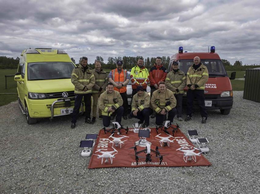
Legal Disclaimer

This document is authored by EENA and DJI staff members with contributions from individual
members of EENA and DJI, and represents the views of EENA and DJI. This document does not
represent the views of individual members of EENA or DJI, or any other parties.

This document is published for information purposes only and it does not declare to be a manual to
operate the RPAS or a statement or interpretation of EU law or the national law of EU Member States.
This document is entirely without prejudice to the views of relevant national statutory authorities
and their legal functions and powers, whether under EU law or the national law of their Member
State. Accordingly, under no circumstances may reliance be placed upon this document by any
parties in compliance or otherwise with any applicable laws. Neither may reliance be placed upon
this document in relation to the suitability or functionality of any technical specifications, or any other
matters discussed in it. Legal advice, technical advice and other advice as relevant, may be sought
as necessary.

                                                                                                         3
                                      EENA / DJI Pilot Project Report
                                 European Emergency Number Association – EENA 112
                                    Avenue de la Toison d’Or 79, Brussels, Belgium
                                          +32/2.534.97.89 ǀ info@eena.org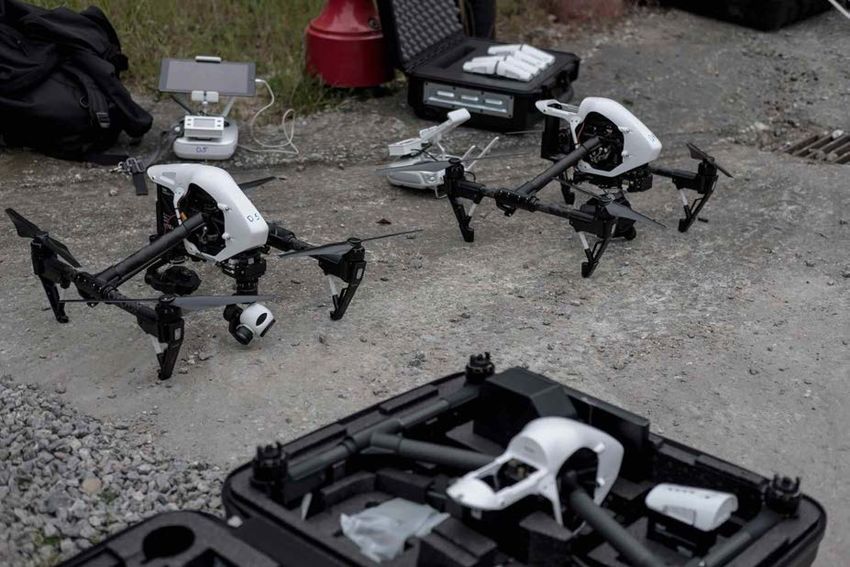
Quotes from the Project participants:

“Mid and West Wales Fire and Rescue Service are proud to have been involved in this project to
explore the wider use of drone technology to assist in the work of emergency responders. The
opportunity to work with other European emergency responders who are pioneering the use of drones
has been a really worthwhile and positive experience.

This technology has significantly improved
situational awareness for our officers and crew
whilst responding to dynamic and complex
emergency situations. Without a doubt access
to real-time thermal imagery and high
resolution optical images has significantly
improved situational awareness to support
dynamic decision-making and therefore
increase the safety of our operational crews
and the communities which we are there to
serve.

It is apparent the role of drones and the
requirements of emergency services in
regards to future technologies will increase
substantially over the next 2 to 5 years. Issues
such as longer endurance, able to operate in
higher wind speeds, optical devices that work effectively in bad weather and deployable payloads
will be a vital requirement for us.

In relation to software the ability to securely and quickly stream to remote locations determined by
the end user as well as online virtual repositories for the images would be considered an advantage.

As a Service we have gained a considerable insight into the use of drones in other European countries
and this information has enabled us to develop our operational procedures to deliver an effective
and vital response capability for our communities and our staff.”
- Mid and West Wales Fire Rescue Service, Steve McLinden

“Using drones as part of our response to incident callouts has enabled us to respond faster and with
more accuracy. We are able to search larger areas with greater accuracy in a shorter time span than
before which makes it possible to deploy other SAR specialists in places where their capabilities are
of better use. Drones have become an inseparable part of our response and their involvement will
only grow with time.”
- REY-SAR, Olafur Jon Jonsson

“On a roof fire in an urban environment, we always have bad angle of view, now we have the
possibility to get a bird's view. We found out that it is essential that the drone is as close to plug and
play as possible, having a great deal of autonomy, but still being able to take control manually.
Drones in the Fire and Rescue services are a tool and should be used as such; you can no hammer
nails with a sponge.”
- Greater Copenhagen Fire Department, Thomas Sylvest

                                                                                                        4
                                     EENA / DJI Pilot Project Report
                                European Emergency Number Association – EENA 112
                                   Avenue de la Toison d’Or 79, Brussels, Belgium
                                         +32/2.534.97.89 ǀ info@eena.org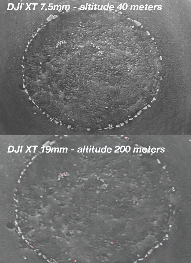
"When Search and Rescue (SAR) teams
respond to a request for help, they do so in
the face of ever changing challenges that
can have a direct impact on the success of
a SAR mission. Nature of terrain, weather
conditions, time constraints, availability of
resources and equipment all play a part in
determining how quickly we locate the
casualty or missing person.

The introduction of drone technology and
best practice protocols for its integration,
alongside existing SAR methods and
techniques, can expedite a successful
outcome. Through this project we have
realised that the use of a drone can help relay situational awareness to those responsible for
coordinating the rescue, so that a life changing decisions can be made quicker. Their use also helps
to mitigate the element of risk that team members have to face when responding, as well as saving
on time to get to, and assessing difficult to reach, locations. “
- Donegal Mountain Search and Rescue, Leo Murray

“Our main goal of this project was to get a more detailed understanding of the needs of first
responders and how off-the-shelf platforms can meet those needs. What we have realized is that a
drone has evolved from being a flying device to a data collection device. Through that it has become
a decision making tool, with applications beyond just locating a missing person or getting a simple
bird’s eye view. This knowledge allows DJI to continue building more capable hardware and software
platforms.”
- DJI, Romeo Durscher

“The project has been a real window into how RPAS are being used and may be used during
emergency responses. We have seen that the pace of technological advancements will continue as
the platforms become more intelligent, more resilient, more innovative and more impactful. This will
lead to more and more RPAS Units being established leading to more user experience being shared
along with best practice information. EENA will continue to focus on the topic as we firmly believe in
the technology and what it can do help the emergency services to make more informed decisions.
Ultimately it will lead to be better outcomes for our citizens. EENA would encourage all emergency
services to evaluate the benefit of RPAS for themselves and we remain available to support them
wherever possible. We also would encourage other RPAS platform manufacturers, integrators,
software and hardware developers to continue to collaborate with the emergency services in an effort
to understand their requirements and help to create future-proof products and applications”
- EENA, Tony O’Brien

                                                                                                    5
                                     EENA / DJI Pilot Project Report
                                European Emergency Number Association – EENA 112
                                   Avenue de la Toison d’Or 79, Brussels, Belgium
                                         +32/2.534.97.89 ǀ info@eena.org
Table of contents

1     Executive Summary ..................................................................................................................... 7
2     Introduction ...............................................................................................................................10
    2.1     Glossary of terms ................................................................................................................10
    2.2     Overall objective of the Pilot Project ......................................................................................12
    2.3     Description of the 4 Pilot sites ...............................................................................................12
3     Use Case examples obtained ........................................................................................................18
    3.1     Example #1 – Fire at an electrical sub-station and Scrap yard ...................................................19
    3.2     Example #2 – Fire involving highly volatile chemicals ..............................................................19
    3.3     Example #3 – Missing persons search ....................................................................................19
    3.4     Example #4 – Missing persons search ....................................................................................19
4     Challenges and solutions identified ................................................................................................20
    4.1     Integration .........................................................................................................................20
    4.2     Training .............................................................................................................................20
    4.3     Hardware ...........................................................................................................................21
    4.4     Live video stream capabilities ...............................................................................................22
    4.5     Tactical approaches .............................................................................................................22
    4.6     Use of thermal imaging camera.............................................................................................23
    4.7     Data from the thermal imaging camera ..................................................................................26
5     Future opportunities identified ......................................................................................................27
    5.1     Pre-incident use of RPAS ......................................................................................................27
    5.2     Post-incident use of RPAS ....................................................................................................28
    5.3     Use of multiple RPAS ...........................................................................................................28
6     Recommendations .......................................................................................................................29
    6.1     Multi-person RPAS units .......................................................................................................29
    6.2     Weather-resistant platforms .................................................................................................29
    6.3     Drop capabilities .................................................................................................................29
    6.4     Identification markers and safety lights ..................................................................................29
    6.5     Integrated broadcasting capabilities ......................................................................................30
    6.6     Multi-camera operations ......................................................................................................31
    6.7     RPAS bundles .....................................................................................................................31
7     Summary and conclusions ............................................................................................................32
8     Annex A – Reports from media outlets related to the project .............................................................33

                                                                                                                                                  6
                                                     EENA / DJI Pilot Project Report
                                              European Emergency Number Association – EENA 112
                                                 Avenue de la Toison d’Or 79, Brussels, Belgium
                                                       +32/2.534.97.89 ǀ info@eena.org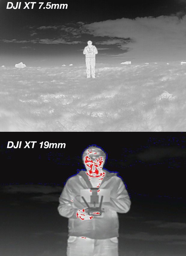
1   Executive Summary

The first responder community is quickly adopting RPAS technology as a standard device in the
emergency management tool kit. As a response to the rapid development of RPAS integration in first
responder missions, EENA decided to set up a working group on RPAS in 2015. The group quickly
grew to a network of 125 members, a strong indication of the interest in the technology. In April
2016, EENA partnered with DJI for an in-depth study of how RPAS technology is used by first
responders pioneering the integration of RPAS in their work. The aim of the project was to learn
more about the use of RPAS for emergency response and to find best practice for RPAS use – in
terms of operational, technical, safety, privacy and legal issues.

Four first responder teams were carefully selected as partners for the research project – Mid and
West Wales Fire and Rescue Service (UK), Donegal Mountain Rescue (Ireland), Greater Copenhagen
Fire Department (Denmark) and Reykjavik SAR Team (Iceland). Between May and October 2016,
the teams used RPAS technology for operations ranging from searching for missing people to putting
out chemical fires.

The key challenges listed below were identified at an early stage and
the participants were challenged to identify best practices over the
course of the project:

    •   Integration of RPAS in Standard Operating Procedure
    •   Training of teams on the use of RPAS
    •   Hardware needs and maintenance
    •   Logistics
    •   External framework for RPAS use

The insights from the project are outlined in this report and will be
shared with the EENA RPAS group as well as with the broader
international first responder community.

Overview of key challenges and recommendations:

Integration of RPAS in Standard Operating Procedure
Thanks to accessible and affordable technology, collecting data relating to the emergency has been
made relatively easy. The challenge is oftentimes how to make the best use of that data – to get the
relevant piece of information to the right person at the right time. Key recommendation includes
having a set-up with a minimum of two people using the RPAS, with one person controlling the unit
and one person searching the video feed for information that can be used for decision-making.
Sharing data over an encrypted channel is a top priority and several third party solutions for this
were examined over the course of the project.

Training of teams on the use of RPAS
While the RPAS team needs to get in-depth training on how to operate the technology, the broader
team, including responsible authorities and team members, need to understand how RPAS fit into
the operation. The RPAS team needs to have a clear role and reporting structure within the bigger
mission.

Hardware needs and maintenance
RPAS manufacturers are improving the technology at a high speed and as RPAS become smarter,
lighter and more powerful, the technology becomes easier to use. During the course of the project,

                                                                                                  7
                                    EENA / DJI Pilot Project Report
                               European Emergency Number Association – EENA 112
                                  Avenue de la Toison d’Or 79, Brussels, Belgium
                                        +32/2.534.97.89 ǀ info@eena.org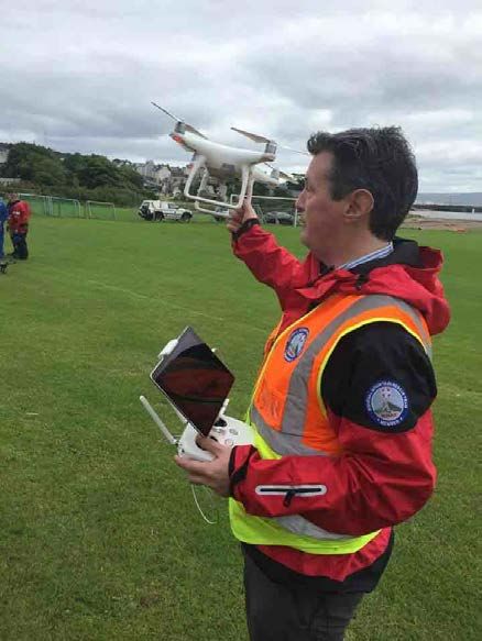
DJI’s Phantom and Inspire series were used with both RGB1 and thermal cameras. One of the test
sites also used a Matrice unit (a developer platform) to develop new software for search and rescue.
Key recommendations from the teams when considering hardware is to make sure the platforms are
reliable and have redundant systems, powerful data transmission links, GPS2 / GLONASS3
integration, and integrated software development kits. Further, the first responder community
articulated the need for weather-proof systems, more powerful lift capability, payload drop capacity
and flashlights for night flying.

Logistics
RPAS technology adds the most value when used directly after an incident, to get a quick situational
overview and to find missing people when time is critical. Therefore, making sure that the RPAS units
are easily accessible is key. Basic recommendations include always inspecting the units for damage
and making sure they are updated with latest firmware. Other key questions to address include
where the units should be stored, how they are best transported to incident site, where they should
be deployed and how battery management is best structured.

External Framework
As with any new technology, educating regulators and the public is important to build trust for the
technology and to ensure a legislative framework that is open for RPAS use. Developing an industry
standard for first responder RPAS to use blue lights is widely supported by the community.
Requirements being able to operate RPAS at
night and beyond visual line of sight

Other key outcomes from the project
In addition to a set of best practices and
recommendations for how to use RPAS
technology, the project resulted in two new
software solutions targeted to the first responder
community:

     1. DroneSAR – a Search and Rescue App
        developed by DroneSAR
     2. DJI HotShot – a customized app for DJI’s
        thermal camera providing a simpler user
        interface where it is easy to adjust
        settings and find relevant temperature
        ranges.

The way forward
We are still at the very beginning of the use of RPAS technology for first response missions. As
hardware and software solutions mature and become customized to the emergency response
community, there will be more case studies and proven best practice for how to integrate RPAS in
standard operating procedures.

DJI and EENA will continue to search for best practices and concrete practical improvements for how
the technology adds value. We welcome feedback and look forward to keeping a close dialogue with
the community. Please feel free to contact us through EENA’s website (http://www.eena.org) or
through http://citizenship.dji.com/

1
    RGB = Red, Green, Blue
2
    Global Positioning System (US)
3
    Globalnaya Navigazionnaya Sputnikovaya Sistema, or Global Navigation Satellite System (Russia)
                                                                                                   8
                                     EENA / DJI Pilot Project Report
                                European Emergency Number Association – EENA 112
                                   Avenue de la Toison d’Or 79, Brussels, Belgium
                                         +32/2.534.97.89 ǀ info@eena.org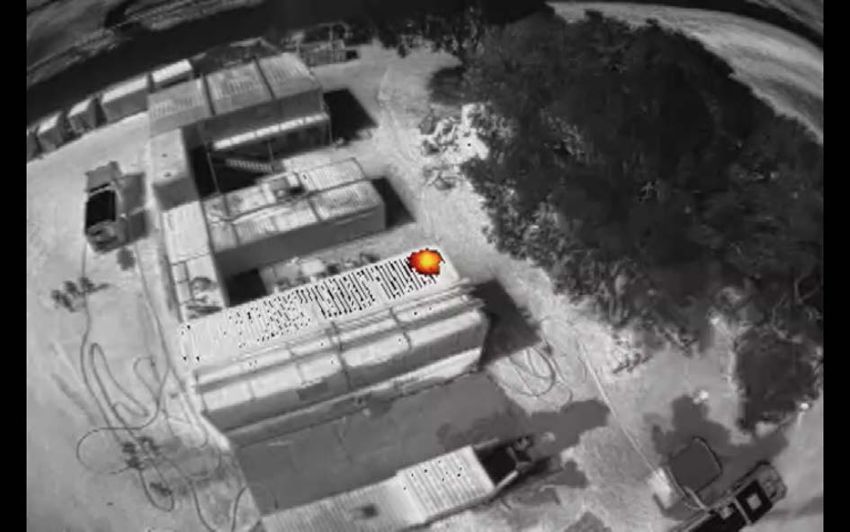
9
     EENA / DJI Pilot Project Report
European Emergency Number Association – EENA 112
   Avenue de la Toison d’Or 79, Brussels, Belgium
         +32/2.534.97.89 ǀ info@eena.org
2     Introduction

2.1    Glossary of terms

               EASA        European Aviation Safety Agency
               EMS         Emergency Medical Services
               FAA         Federal Aviation Authority
               FLIR        Forward Looking Infra Red
               FRS         Fire and Rescue Services
               GLONASS     Globalnaya Navigazionnaya Sputnikovaya Sistema, or
                           Global Navigation Satellite System (Russia)
               GPS         Global Positoning System (US)
               HD          High Definition
               ICAO        International Civil Aviation Organisation
               IC          Incident Commander
               IMU         Inertial Measurement Unit
               LEA         Law Enforcement Agencies
               RPAS        Remotely Piloted Aircraft Systems
               SAR         Search and Rescue
               SDK         Software Development Kit
               UAS         Unmanned Aircraft Systems

Remotely Piloted Aircraft Systems (RPAS) is a term given to the more widely known term of ‘drones’
and is the term most commonly used by International Civil Aviation Organisation (ICAO)4 to describe
the civilian use of a remotely piloted aircraft, the remote pilot station and the data links. RPAS is in
effect a subset of the other term that is used to describe drones which is Unmanned Aircraft Systems
(UAS), which also includes aircraft that can be programmed to fly autonomously without the
involvement of a pilot. RPAS as the name suggests are controlled by a pilot from a distance and by
their nature, are able to fly closer to objects than traditional manned aircraft and the only difference
is that the pilot is not on board the aircraft.

RPAS come in all shapes and sizes, weighing from just a few grams and can go up to several kilos
and even greater. As they are defined as aircraft, their use must be controlled by observing certain
rules and regulations. There are efforts across Europe and other parts of the World to create a
legislative framework regarding the use of RPAS; many countries already have rules regarding their
use and the European Aviation Safety Agency (EASA) are currently in the process of setting the rules
for Europe5. In the US, the Federal Aviation Authority (FAA) have published their rules6 on the use
of RPAS and whilst the project scope was not to examine the regulatory rules, the fact of the matter
is that all RPAS operators should be familiar with them and abide by them uniformly.

Their capabilities also vary with many platforms offering different functionalities and specifications.
What is known however is the fact that the use of RPAS by the emergency services, SAR and First
Responder communities is growing rapidly and that the technology onboard the RPAS is also
changing rapidly. The RPAS used 2 years ago is almost certainly different to the ones available today

4
    ICAO Circular 328/2011
5
    EASA RPAS rules as at October 2016
6
    FAA RPAS rules as at October 2016
                                                                                                     10
                                     EENA / DJI Pilot Project Report
                                European Emergency Number Association – EENA 112
                                   Avenue de la Toison d’Or 79, Brussels, Belgium
                                         +32/2.534.97.89 ǀ info@eena.org
and with this pace of change, the RPAS in 2 years from now will look, perform and offer so much
more than the platforms of today.
At a macro level, the European Commission stated in April 20147 that there were “1,708 different
RPAS referenced worldwide of which 566 in Europe, being developed or produced by 471
manufacturers worldwide of which 176 in Europe”. Whilst the real or current figure may be difficult
to establish, the sale of RPAS has risen several fold since that date with US officials estimating that
the sales of civilian drones in the US during the Christmas holiday season in 2015 was over 1 million
units. Research firm Markets and Markets estimates that
the global drone market will grow at a compound annual
growth rate of 32% between 2015 and 2020 into a $5.6
billion industry8. The firm estimates that among
applications, precision agricultural drones will enjoy the
highest demand along with First Responders, media
production, retail, inspection, mapping services, and
education.
So why would the emergency services, SAR agencies and
First Responder communities look to RPAS as a tool to
support their work? First of all, the aforementioned
communities have different requirements and not all of
them would see RPAS as part of their toolkit. For example,
many Emergency Medical Services (EMS) probably
wouldn’t use RPAS whilst SAR and particularly Fire and
Rescue Services (FRS) have identified RPAS as a real asset
and can readily identify with their capabilities. Law
Enforcement Agencies (LEA) can also benefit from the
RPAS technology particularly from a crowd management
perspective and possible counter terrorism perspective.
For their part, SAR organisations use RPAS during the
search phase of an operation and use its capability to make
fast, efficient and effective searches over vast swathes of
land.
But there are many examples of where RPAS have not been used responsibly and we have seen
reported issues where civilian operators have hampered the work of the emergency services by
getting in way of rescue helicopters and fixed-wing aircraft. The media has reported on such issues
previously and clearly work needs to be done in terms of educating RPAS operators about the rules
that should adhered to.
RPAS are proving to be a real asset and can assist during emergencies and disaster relief operations
by supporting better decision-making. They can help the emergency services to get an “eyes on”
perspective of the operation and provide videos and images to the Incident Commander (IC) on the
ground. With the availability of thermal imaging cameras, high resolution images and 4k video
quality, the RPAS technology is delivering enhanced capabilities to the emergency services.
All of this ensures better outcomes for those in need of help and importantly also helps to keep our
emergency services, SAR teams and First Responders protected and safer than ever before.
7
COM(2014) 207
8
Markets and Markets Research Report
11
EENA / DJI Pilot Project Report
European Emergency Number Association – EENA 112
Avenue de la Toison d’Or 79, Brussels, Belgium
+32/2.534.97.89 ǀ info@eena.org2.2 Overall objective of the Pilot Project
In June 2015, EENA established a Working Group on Remotely Piloted Aircraft Systems (RPAS) in an
effort to understand more about the technology and how it could support the work of the emergency
services, search and rescue (SAR) and First
Responder communities. The Working Group, now
with 125 members from 39 countries, issued a
White Paper9 later in 2015 and in doing so made
a number of key Recommendations. One of the
Recommendations was that the RPAS
manufacturers needed to get closer to the
aforementioned communities in an effort to
understand their requirements and thus create
platforms and technology that were suited to their
needs.
The project concept was developed by EENA
following on from the discussions held during the
RPAS Working Group and from the interest levels
identified during the EENA Conference of 2015.
There were a number of objectives and targets for the project, namely:
• To learn about the various needs and requirements of the emergency services and SAR teams
• To establish and review several use-case scenarios in order to understand how RPAS
technology could be implemented and optimized
• To gain a deeper understanding of the impact of data management and to identify what
type of data is wanted/needed, what the impact of such data is, how it could be
integrated into the command and control process and how it could be analyzed either in
real-time or in a post-event review.
• To understand what the operational procedures are involved in a ‘RPAS team’, what the
correct skill sets might be, their function, the reporting structure.
• To understand the criticality of communications within a ‘RPAS team’ and how
communication in general is handled with the other members of the response team and/or
other partner organizations and authorities
• To understand the post mission procedures carried out by the ‘RPAS team’ including the
safe packing up of the technology, its cleaning and maintenance, logging of noticed
problems, repair of the technology, storage of data and the compilation of the mission reports.
In overall terms, the objectives were covering operational, technical, safety, privacy and legal issues
with many issues overlapping between several objectives. In addition the project focused on the
‘human’ element and how communication, teamwork and individual behaviours would impact on the
RPAS team.
2.3 Description of the 4 Pilot sites
And so in April 2016, EENA announced an exciting partnership with DJI to do exactly that. EENA and
DJI invited applications from emergency services organizations to take part in the Pilot project. 41
applications were received from organizations not only from Europe but from the USA, Australia and
New Zealand. Such a reaction is an indicator of the level of interest in the topic and demonstrates
9
EENA White Paper 20 November 2015
12
EENA / DJI Pilot Project Report
European Emergency Number Association – EENA 112
Avenue de la Toison d’Or 79, Brussels, Belgium
+32/2.534.97.89 ǀ info@eena.orgthat the Emergency Services and First Responders are keen to learn more about the technology and
educate themselves on its capabilities.
EENA and DJI then selected four Pilot sites that have varying operational challenges. Whilst not a
prerequisite, all of the Pilot sites selected had previous RPAS experience and were developing plans
and strategies for integrating RPAS into their operation.
The four Pilot sites selected from the list of applicants were:
Donegal Mountain Rescue Team (Ireland)
Donegal MRT was established in 1982 and is a voluntary SAR service is located in the
northwest of Ireland and covers a landmass of 4,861km2. Its topography is
predominantly mountainous with both coastal and inland mountain ranges.
Approximately 1/3 of its SAR response is done in close cooperation with the Irish
Coastguard units along the coastal mountain ranges. Typically it receives 50 callouts per
year. It is comprised of 35 team members including one search dog unit. Donegal MRT
works closely with all the other Agencies such as the Police, Aer Corp, Civil Defense and
Irish Coastguard and they started testing and trialing RPAS in September 2015 in remote
locations and in various weather conditions. Donegal MRT are keen to see the
development of RPAS for SAR missions as well as protocols and techniques for using
RPAS in remote and hard to reach locations. They also are keen to develop a first
responder shared database facility to enable visualization / identification of images
received live to team members remote from the SAR incident site. Donegal MRT also
aim to develop a bespoke software solution with ‘real time’ networking capabilities
including ‘crowd sourcing’ and to investigate potential drone use to act as a repeater
system to improve visual line of sight issues.
The team predominantly use a DJI phantom 4 and Inspire drone with the Zenmuse X3
and XT camera. Operating as a 2-3 person team comprising a drone operator, drone op
“attendent” who works and prepares in advance of the operators needs and a team
member to forward plan, navigate, and relay communications and progress to incident
command.
13
EENA / DJI Pilot Project Report
European Emergency Number Association – EENA 112
Avenue de la Toison d’Or 79, Brussels, Belgium
+32/2.534.97.89 ǀ info@eena.orgGreater Copenhagen Fire Department (Denmark)
Greater Copenhagen Fire Department is a relatively new organization as Copenhagen
Fire Department. merged with 7 other Fire Departments on 1 January 2016. The
Copenhagen Fire Department was founded in 1687 and covered the center of
Copenhagen, Now the Greater Copenhagen area covers approximately 1 million citizens
and welcomes over 10 million tourists per year.
With 1000 employees, 12 stations and more than 80 rescue vehicles Greater
Copenhagen Fire Department is by far the largest Fire and Rescue Service in Denmark.
The area covers more than 100km coastline as well as key strategic and historical
landmarks such as the Queens Palace, the main Government building, a large number
of historical buildings in the heart of the old town In addition to this Greater Copenhagen
Fire Department also covers Copenhagen harbour with its oil port and several large
industrial production companies.
In crisis situations one of the first requirements is to get the best situational awareness
information as quickly as possible and to that end, the RPAS is a key strategic asset.
Since Greater Copenhagen Fire Department began using a RPAS in 2014, Captain
Thomas Sylvest has been the only pilot. At the start of 2017 they now expect to have
an additional 6 pilots, so they’ll be available 24/7. The RPAS unit uses three different
setups with the DJI Inspire - one with a Z3 zoom camera, a FLIR XT Thermal camera,
and the ZT zenmuse camera.
14
EENA / DJI Pilot Project Report
European Emergency Number Association – EENA 112
Avenue de la Toison d’Or 79, Brussels, Belgium
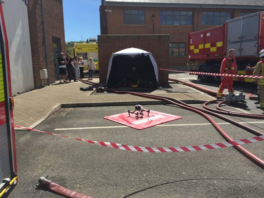
+32/2.534.97.89 ǀ info@eena.orgMid and West Wales (UK)
Mid and West Wales Fire and Rescue Service makes up almost two-thirds of Wales,
covering a predominantly rural area of 4,500 square miles (11,700 km2), comprising
58 stations and employing 1,200 staff. It is the third largest in the United Kingdom,
behind the Scottish and Northern Ireland Fire Services.
There are a variety of risks found within the Service area, ranging from the
petrochemical industries in Milford Haven, to the risks associated with heavily
populated areas such as Swansea and Neath Port Talbot.
There is also a large farming community and many other light industries throughout
the area. These, together with an extensive coastline and inland waterways, form
some of the specialised risks found within the Service.
The Service currently has two RPAS platforms, The DJI Inspire1, with XT camera and
forward pilot view camera, and the Aeryon Skyranger with 30x HD zoom camera and
combined Thermal and optical camera.
The RPAS’s are embedded within our Urban Search and Rescue Team and are
deployed along with our search dogs. MAA currently have 10 CAA approved drone
pilots who are ‘flexi-duty’ operational response managers. MAWW provide 24/7, 365
days a year cover and crew the RPAS as a minimum team of two, one pilot and one
camera operator/flight coordinator.
Though the development of our capability they have acquired a number of accessories
to assist effective RPAS deployment, this includes a pop -up darkroom tent which acts
as a flight operations briefing point with large screen monitor; LTE WIFI mobile
communication capabilities to enable live streaming and remote commander and pilot
dynamic interface; LED illuminated landing mat and night time landing zone beacons.
The success of the Air Support Unit through the current RPAS capability has enabled
a range of collaborative partnerships to be developed with key partners such as Dyfed
Powys Police, Natural Resources Wales and South Wales Fire and Rescue Service.
15
EENA / DJI Pilot Project Report
European Emergency Number Association – EENA 112
Avenue de la Toison d’Or 79, Brussels, Belgium
+32/2.534.97.89 ǀ info@eena.orgReykjavík Search and Rescue (Iceland)
Hjálparsveit skáta í Reykjavík (REY-SAR), founded in 1932, is one of the largest and
oldest search and rescue teams in Iceland. It is located in Reykjavík, the capital of
Iceland, which is surrounded by mountains, woodland areas, lakes and rivers, lava
fields, international airport and the ocean. This creates a diverse area of activity
which has resulted in the team adopting a wide range of capabilities.
Search and rescue operations are the mainstay of its deployments, counting for 74%
of incidents, but the team also handles a wide range of service engagements for The
Icelandic Road and Coastal Administration and other government agencies.
REY-SAR began studying the use of drones in early 2015. The goal was to
systematically and methodically study their capabilities and find out where they could
best fit into the team's operations. Drones were first used in an official capacity in
September 2015 and are now fully integrated into the team's response mechanism.
Drones have been successfully deployed in multiple incidents over the past year.
Their continued use has evolved and expanded during that time and continues to
develop. The addition of a thermal camera was a game changer as it expanded the
operational capability of the drones to 24/7 all year round. The thermal camera drone
has been delivering positive results and with more use and more experience it will
continue match and exceed expectations.
16
EENA / DJI Pilot Project Report
European Emergency Number Association – EENA 112
Avenue de la Toison d’Or 79, Brussels, Belgium
+32/2.534.97.89 ǀ info@eena.orgEach of the 4 Pilot sites were provided with DJI equipment to use during real emergency situations
and their feedback as to how the technology was used, how it performed and how it could be
improved was obtained. The project has had just short of a 6 month window and followed on from a
kick-off Workshop which was held in Copenhagen in May. Throughout the project, the participants
took part in various conference calls together and shared information on their use cases and the
experiences they had using the equipment.
17
EENA / DJI Pilot Project Report
European Emergency Number Association – EENA 112
Avenue de la Toison d’Or 79, Brussels, Belgium
+32/2.534.97.89 ǀ info@eena.org3 Use Case examples obtained
During the course of the project there were 60 call-outs requiring the expertise and capability of the
RPAS unit from each of the four Pilot sites. The call-outs varied in nature and were consistent with
the role of the Pilot site and the availability of the RPAS team. Many of the Pilot sites were also
providing cover and support to other emergency services during real emergencies. In addition many
of the Pilot sites took part in multi-agency training exercises and national fora to discuss the future
of RPAS in their country.
In the chart below all 60 call-outs have been classified together and presented in an anonymized
fashion.
Volume and type
of call-outs during June-Sep (inclusive)
18
16
14
12
10
8
6
4
2
0
In approximately 40% (25) of these cases, the RPAS unit was deployed but it was ‘stood down’ by
the Incident Commander either upon arrival on scene or prior to arrival. Looking deeper into these
cases, 17 of them were stood down because the missing person had been located. The distance that
the RPAS unit had to travel in order to reach the incident site may have been a factor in some of
these cases.
One of the key elements of being able to respond to a call-out request is of course the weather.
Weather conditions can vary and there were several examples during the project where the RPAS
team was not able to deploy because the weather conditions were not safe to operate in and as a
result they had to be stood down. Low visibility caused by low cloud, fog as well as high winds can
hinder a RPAS unit from being deployed and as ‘safety-first’ is always the first consideration, the
RPAS unit sometimes has no choice but to stand down. This is also the case with some fixed wing
aircraft and even helicopters so it is not unusual.
Looking at the number of cases where the RPAS unit was stood down, 3 (5%) of them were caused
by adverse weather conditions. Whilst this figure is low, it should be pointed out that the project
took place mostly during the summer periods where the weather is more favourable.
18
EENA / DJI Pilot Project Report
European Emergency Number Association – EENA 112
Avenue de la Toison d’Or 79, Brussels, Belgium
+32/2.534.97.89 ǀ info@eena.orgListed below are samples of the types of call-outs reported by the 4 Pilot sites during the project.
They have are just examples of some of the types of call-outs and they have been anonymized in
order to respect the relevant data privacy requirements that exist in the respective countries:
3.1 Example #1 – Fire at an electrical sub-station and Scrap yard
A high voltage electrical sub-station was on fire and had been well alight when the RPAS team arrived
on scene. The radiated heat was already spreading to industrial recycling processing plant and nearby
cylinders. The RPAS was deployed and used to provide an overall scene view to assist Incident
Commander in terms of planning, track smoke plume etc. The thermal camera was used to monitor
radiated heat transfer and guide defensive fire fighting
operations. Images also used to check reports of children
at rear of site and saved crews being deployed into the
hazard area when the claim was discovered to be incorrect.
3.2 Example #2 – Fire involving highly volatile
chemicals
A fire at a waste storage area at an industrial titanium
milling company was reported. It was discovered upon
arrival that the fire was in discarded oil soaked rags, which
were in danger of heating and setting fire to highly volatile
titanium swarf. Optical and thermal cameras were used for
scene overview and risk assessment. The thermal camera
was used to track the fire spread and temperature of the
titanium swarf barrells close to the fire. Crews with
covering jets, guided by the RPAS optical images, were
used to ensure that the foam hit the seat of the fire whilst
crews were behind concrete protection therefore
minimising risk to crews.
3.3 Example #3 – Missing persons search
A missing person report was made known to the RPAS unit who deployed and begun a wide area
search of the area where the person was reported missing from. In this case it was a river and marsh
area. The RPAS unit used the thermal camera and located the missing person and supported the
Police in approaching the person. The RPAS reduced the search time to less than 15 minutes whereas
a ground team would have taken a multiple of this to locate the missing person. As well as an
effective and efficient response, the RPAS unit afforded protection to the emergency services on site.
Live streaming and image sharing with other agencies allowed for shared situational awareness
information.
3.4 Example #4 – Missing persons search
The RPAS unit were informed of a missing person in an area of known lava fields that are extremely
difficult to traverse. The Incident Commander suspected that the missing person was not in that
location but nevertheless had to make certain and rule out the possibility for certain. The RPAS
searched the wide area in 40 minutes confirming that the area was clear. A ground team searching
on foot would have taken between four to six hours and possibly with a much greater degree of
19
EENA / DJI Pilot Project Report
European Emergency Number Association – EENA 112
Avenue de la Toison d’Or 79, Brussels, Belgium
+32/2.534.97.89 ǀ info@eena.orguncertainty. The RPAS team had to fly in between rain
showers, mist and gusts of wind but conducted a series
of flights that were hugely beneficial to the operation and
eventual location of the missing person.
In summary, there were many, many use cases where
the RPAS units were deployed during the duration of the
project; simply there were too many to list. Incidences
like the ones above are good use-cases of how the RPAS
unit could provide an overview perspective of the
incident, provide live footage to the Incident / Search
Commander and allow him/her to make more informed
decisions. The technology also provided the responding
teams with an added layer of protection and kept them
safer ultimately.
4 Challenges and solutions identified
The integration of new technologies into first responder processes can provide challenges. This is
especially true when the technology itself is new, its use cases are still being explored and tactical
implementations are being explored. It was discovered that the majority of challenges were observed
in both fire as well as search and rescue environments, leading to the conclusion that aerial drone
technology requires an adjustment of thinking and implementation on a large scale.
4.1 Integration
The fundamental question “How can a drone be integrated?” is an interesting one as there is not one
simple solution. Throughout the project it was discovered that the addition of an aerial platforms
requires a level of adjustment of the first responder team and their processes.
Having an aerial view of an incident site provides very valuable information to the incident
commander and the ground teams. However, the implementation processes to get to just that point
are important;
• Who is/will be the drone operator and how big will the team be?
• Where will the drone be stored before an incident?
• How will the drone be transported to the incident site?
• When will a drone be deployed?
• What information is requested/required?
• How will the information be shared during the incident situation?
• What is the tactical approach? Will the drone be used as a single aerial point of view device?
Will it move to get different perspectives?
• What is the proper training for drone operator?
• What are the regulatory requirements?
4.2 Training
Proper understanding of the hardware and software, as well as how to use it, is a fundamental factor
of success and nothing new to the first responder community. In order to effectively use equipment
20
EENA / DJI Pilot Project Report
European Emergency Number Association – EENA 112
Avenue de la Toison d’Or 79, Brussels, Belgium
+32/2.534.97.89 ǀ info@eena.organd technology, a proper training process has to be established. Furthermore, in order to keep
proficiency, different training scenarios need to be executed throughout the year to simulate real-
life scenarios.
The recommendation is to for not only the drone and camera operators, the visual observer, but also
the incident commander to learn about the aerial technology, its capabilities, use cases, including
the data output (video/images recorded, video live transmission, other data gathered), maintenance
and data storage.
Initial training should be conducted in open and wide areas, away from people, structures and trees.
If an operator is new to the technology, getting him/herself familiar with the functionalities is very
important. Just basic flying skills are an absolute baseline before any further training.
First Responder Training Service providers have started to create and teach specific curriculums
based on the needs of first responders. These training programs allow for very specific hands-on
training, and also go into many of the tactical approach questions and scenarios.
4.3 Hardware
One of the most common questions has been what RPAS system should be used. This project
evaluated a variety of off-the-shelf DJI platforms. From quadcopters (four arms, four motors, four
propellers) to (six arms, six motors, six propellers). All had an integrated camera and the ability to
live-stream HD footage and telemetry information to the RPAS operator. One of the quadcopter
platforms (DJI Inspire 1) had a modular camera system set-up, allowing for easy exchange of
camera payloads. Each pilot test site also received a DJI/FLIR XT thermal camera. FLIR System is
the world’s largest commercial company specializing in the design and production of thermal
imaging cameras, components and imaging sensors.
A minimum RPAS configuration for first responders has to include/provide the following:
• Reliable platform with redundant system; i.e. dual IMUs (Inertial Measurement Unit, an
electronic device that measures and reports a body’s specific force and angular rate and
allows a RPAS to work when there is no GPS), dual compass, dual battery etc.
• GPS and GLONNAS systems
• Integrated camera systems, preferably modular, with live downstream capabilities in HD
format.
• Ability to fly in moderate winds and light rain
• Integrated SDK (Software Development Kit) so specific apps can be written to help operators.
For example the DJI/DroneSAR Search and Rescue app, DroneDeploy for 2D and 3D mapping
etc.
The following features enhance the RPAS capabilities and are not considered part of the minimal
configuration.
• All weather proof; while helpful to be able to fly in moderate to strong winds, using an RPAS
in rainy conditions impact video and still image quality to the point where it becomes less
helpful.
• Dual operation; ability to have a dedicated pilot and a dedicated camera operator can provide
advantages.
• Lift capabilities beyond the camera payload weight; this could be helpful for delivery of
supplies, such as life vest, first aid kit, blanket or radio during a search and rescue mission.
• Flashlight / beam light for night time flying and illumination
21
EENA / DJI Pilot Project Report
European Emergency Number Association – EENA 112
Avenue de la Toison d’Or 79, Brussels, Belgium
+32/2.534.97.89 ǀ info@eena.org4.4 Live video stream capabilities
Very early on during the project period it was determined that the ability to live stream the RPAS
footage to not only the operator, but to a incident command centre and/or other crews on the ground,
was an important feature.
The challenge is that if only the RPAS operator sees the live footage, the operators has to “digest”
all the footage and data and then communicate the data and information to incident command. That
creates a bottleneck in the data and information flow and minimises the impact the RPAS platform
has. Furthermore, this distracts the operator from the pilot in charge tasks and can lead to tactical
use issues. Also, communicating and
describing visual clues from the RPAS
operators to incident command not only
slows down the process, but could lead to
miscommunication and misunderstandings.
Since the platforms used on this project all
use a smart device as the viewing device,
the DJI Go app allows for live or near-live
broadcast to YouTube. By creating a private
channel, incident command could view the
footage by going onto that private channel
on YouTube (via web browser). The original
footage continues being stored on a micro-
SD card on board the aerial platform and
can be retrieved post flight.
During this project a variety of solutions were looked at, including a backpack with several cellular
modems that get the data from the RPAS’s radio controller via an HDMI out and broadcast it to a
specific server. Copenhagen Fire Department used and implemented this solution.
Future solutions could be seen through DJI’s SDK (Software Development Kit) and could include
functionality to broadcast video stream to additional platforms.
4.5 Tactical approaches
Different first responder incidents and scenarios require a different tactical approach on how an aerial
platform is being used. Furthermore, depending on the terrain, the goal of the mission and the flight,
that determines how the RPAS is being used.
For example during a structural multi story house fire, the RPAS operator may just want to select a
fixed position above and slightly to the side of the incident to gather an overall view. This bird eye
view could be provide data by either utilizing a regular or a thermal imaging camera. The operator
would watch for the plum of smoke and try to always stay clear from the smoke by slightly adjusting
location or altitude.
However, if the goal is to get a more detailed view of the incident site, the operator may choose to
set-up an autonomous flight route, such as a Point Of Interest. The RPAS, in that flight mode, will
fly a predetermined sized circle around the incident area, keeping the camera pointed at the centre.
This allows the operators to observe the incident side from all sides.
22
EENA / DJI Pilot Project Report
European Emergency Number Association – EENA 112
Avenue de la Toison d’Or 79, Brussels, Belgium
+32/2.534.97.89 ǀ info@eena.orgSimilarly during search and rescue missions there are multiple ways to execute a mission. Depending
on the environment and the terrain different tactical approaches are available to the operator. A flat
area with high grass and brushes may result in flying a Z-pattern approach with the camera on the
RPAS pointing straight down (-90 degrees). While a hill or mountain side may require a different
flight pattern.
4.6 Use of thermal imaging camera
A clearly-visible, glowing heat signature amidst a mass of snow or water can make a life-saving
difference. Thermal sensors can see in total darkness, see through obscurants such as smoke, light
fog, rain, dust and foliage, can measure temperature in non-contact assessments and diagnosis,
reduce atmospheric interference and provide better contrast and are an ideal platform for reliable
analytics and stand-off detection of gas emissions.
During initial early search and rescue tests it
was noted that in certain conditions, and with
the incorrect thermal imaging camera
settings, the results showed many false
positives and that the software interface, the
DJI Go app, was too complex to dial in the
appropriate thermal imaging camera/isotherm
settings.
That feedback lead to the development of an
internal standalone app named “DJI Hotshot”
for use with the DJI XT thermal imaging
camera. The app provides a much simpler
approach and user experience with bigger
buttons and sliders to adjust thermal imaging
camera settings and isotherm settings,
making it much simpler and faster to dial in temperature ranges.
And additional challenge when flying with a thermal imaging camera is to keep situational awareness
and orientation. Due to the fact that a thermal imaging camera is using infrared radiation, instead
of using visible light like regular photography/videography cameras, a familiar surrounding can
appear very different looking. The use of DJI telemetry becomes even more helpful during flights
with a thermal imaging camera.
The selection of the appropriate XT lens size is another important factor.
The highest resolution thermal imaging camera DJI is offering, at 640x512 FPA/Digital Video Display
Formats size, has four different lens options; 7.5mm, 9mm, 13mm & 19mm. While the camera also
offers 2x, 4x and 8x digital zoom, the smaller lens options (7.5mm and 9mm) appear to be the more
useful lens size as it provides a wider field of view. Below is a comparison between the 7.5mm and
the 19mm.
The first comparison has the XT thermal imaging camera on the DJI Inspire 1 on the ground with
the subject the same distance away from the platform. The 19mm lens has a much narrow field of
view and captures the upper body only. In order to capture the entire body, the distance between
the platform and the individual would have to be increased dramatically.
23
EENA / DJI Pilot Project Report
European Emergency Number Association – EENA 112
Avenue de la Toison d’Or 79, Brussels, Belgium
+32/2.534.97.89 ǀ info@eena.orgThis is better shown in the second comparison. This time the DJI Inspire 1 with the XT thermal
imaging camera is airborne over a stone circle. The diameter of the circle is 44m. With the 7.5mm
lens the platform has to only be raised 40m above the ground to capture the entire circle while with
the 19mm the platform has to be raised to 200m in order to capture almost the entire circle.
Ground comparison between the 7.5mm and 19mm lens options on the DJI XT thermal imaging
camera. Distance from camera to subject is the same in both.
24
EENA / DJI Pilot Project Report
European Emergency Number Association – EENA 112
Avenue de la Toison d’Or 79, Brussels, Belgium
+32/2.534.97.89 ǀ info@eena.orgIn air comparison between the 7.5mm and 19mm lens options on the DJI XT thermal imaging camera.
25
EENA / DJI Pilot Project Report
European Emergency Number Association – EENA 112
Avenue de la Toison d’Or 79, Brussels, Belgium
+32/2.534.97.89 ǀ info@eena.org4.7 Data from the thermal imaging camera
Depending on the thermal imaging camera settings, reviewing the live data during an incident can
result in too much data being displayed. This is especially true when the operator is not familiar with
the functionality and the way data from thermal imaging cameras are being displayed.
Thermal imaging cameras have different pre-set palettes available, with distinct colours used to show
temperature differences in the thermal image, which are related to the grayscale intensity. However,
these palettes may show too much data, data outside of the useful temperature range. Here is an
example of a heat source inside a structure in two different views. First view is a standard Fusion
palette view. The second image is using the Isotherm settings, which allows for easier review and
analysis of thermal data, as it immediately shows the hot-spot. Isotherm is an analysis tool to give
the operator a specific temperature range which stands out from the rest.
Example of structural fire as seen with the DJI XT thermal imaging camera in the Fusion palette.
26
EENA / DJI Pilot Project Report
European Emergency Number Association – EENA 112
Avenue de la Toison d’Or 79, Brussels, Belgium
+32/2.534.97.89 ǀ info@eena.orgExample of structural fire as seen with the DJI XT thermal imaging camera and Isotherm settings ON.
5 Future opportunities identified
The development of RPAS hardware will continue to provide users with more capable platforms in
the future. Integration of sensors in platforms will continue and through the data gathered with all
the sensors, the platforms can make appropriate flight corrections. For example forward facing
sensors on newly released platforms allow for the detection and avoidance of objects, during not
only autonomous flight, but also manual flight.
On the software side we will be seeing a more SDK streamlined platform, allowing for the creation
of more powerful SDK applications and solutions. The combination of hardware and software
improvements will allow future platforms to perform more challenging tasks, utilise more
autonomous functions and provide more useful real-time data to the operator and other team
members.
5.1 Pre-incident use of RPAS
Throughout this project it was realized that the use of RPAS extends beyond just being used on and
during an incident. The project learned about the desire to prepare for incidents, such as a fire and
flooding, by creating up-to-date 2D, 3D or elevation maps ahead of time. By use of SDK solutions
for mapping (i.e. DroneDeploy, Propeller, Pix4D etc.) and a Phantom 4 or Inspire 1 platform, areas
or buildings can be mapped from the air. These maps are not only more current than Google Satellite
views, but also offer higher resolution and allow for very precise measurements.
27
EENA / DJI Pilot Project Report
European Emergency Number Association – EENA 112
Avenue de la Toison d’Or 79, Brussels, Belgium
+32/2.534.97.89 ǀ info@eena.orgYou can also read