The Weather Wire - Skyview Weather
←
→
Page content transcription
If your browser does not render page correctly, please read the page content below
The Weather Wire
July 2020 Volume 27 Number 7
Contents:
• Drought Conditions Expanding as 2020 Monsoon season is a NO-
Snow so Far!
• Drought Monitor
• July Summary/Statistics
• August Preview
• Rainfall Totals
Drought Conditions Expanding as 2020 Monsoon
Season is a NO-Show so Far!
The North American monsoon provides much needed moisture for the Desert SW
portion of the United States and this year the monsoon has been brief and weak over
the state of Colorado and all of the SW for that matter. The word “monsoon” is typically
associated with heavy rainfall, and yes that can be a by-product... But. in reality the
term "monsoon" really just means a change in the predominant upper level wind flow
pattern. In the SW US this corresponds with the North American monsoon as moisture
is pulled up from the Gulf of California due to S/SSW flow aloft, while Gulf of Mexico
air intrudes over the eastern plains at the surface due to E/SE flow. When these two
factors come together in tandem, we can certainly have thunderstorms that produce
heavy rainfall. The upper level flow has generally been a W to NW flow up through
the 3rd week of July, then a brief monsoon moisture plume arrived on the 3rd week of
the month providing much needed moisture for the mountains and portions of S CO,
but northeastern areas of the state did not get in on the act to the same degree.
Granted there were some storms but rainfall was generally on the lighter side,
especially Denver northward to Fort Collins. The S/SW upper level flow did not last
long as by the end of the month we were right back in a W to NW upper level flow
pattern, essentially cutting off the monsoon. The NW upper level flow can produce
storms with heavy rainfall as well as severe weather with hail being the most common
culprit. NW flow is typically stronger though which results in the storms moving rather
quickly not allowing for a sustained period of moderate and heavy rain and lowering
the potential point rainfall amounts as the fast motions limit the amount of rain a single
storm can produce over a single location. There will be a few last gasps of the
monsoon season this month and possibly into the first few weeks of September but it
will be too little too late to make a dent in the lack of moisture over the summer season
to date. The lack of a sustained monsoon season has resulted in many areas of the
state reporting just a fraction of normal precipitation outside of a few areas that have
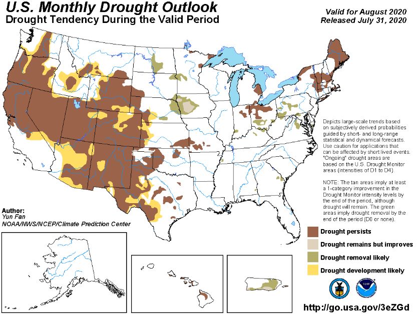
experienced the isolated stronger storms. Colorado is rapidly falling into severe and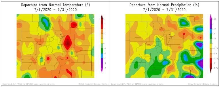
extreme drought conditions and with some of the drier months of the year coming up
it is pretty safe to say that the drought is not going to go away anytime soon and may
be a factor for many months or even years. The look ahead into fall and winter from
the Drought monitor suggests that the warmer and drier conditions will continue into
the fall, winter and even potentially into next Spring. ENSO trends are also pointing to
a La Nina this Winter which can often result in a below normal snow season for areas
of Denver southward along the I-25 corridor. Below are 3-Month maps from the
drought monitor showing the warmer and drier than normal trends expected into 2021:

Temperature Trends:

Precipitation Trends:
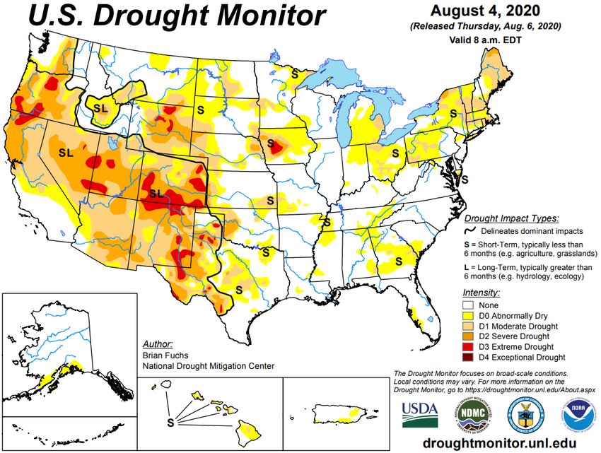
Drought Update
Severe to extreme drought conditions are expanding over much of Colorado with the most
extreme drought over southern and eastern portions of the state.

The map below shows forecasted temperature deviances for August 2020. The map shows
a bias towards above normal temperatures over all of CO, especially over SE CO.
The map below shows forecasted precipitation deviances for August 2020. The map shows
and equal chance for above or below normal precipitation over all but far SE CO, however
the drier than normal trend is expected to continue..

Colorado is expected to see persistent and worsening drought conditions this month over
the entire state and much of the intermountain West.
July Summary

July of 2020 was another dry month with above normal temperatures. Average highs
for the month were 92.4 degrees which was 3.0 degrees above the normal of 89.4
degrees. There were 23 days during the month with a high temperature of 90 degrees
or more with 3 days recording a high temperature of 99 degrees. There were not any
100 degree days recorded at DIA. Average lows for the month were 60.7 degrees
which was 1.8 degrees above the normal of 58.9 degrees. The coldest reading during
the month was a low of 52 on the 1st. Combining the average monthly high and low
temperatures resulted in a monthly mean temperature of 76.5 degrees which was 2.3
degrees above the normal of 74.2 degrees. Precipitation for the month at DIA came
in at 0.95” which is 1.21” below the normal of 2.42”. Many Denver Metro area locations
struggled to reach 1” of moisture for the month with a few areas not even reaching
0.50” for the entire month of July. Yearly precipitation at DIA now stands at a measly
4.87” which is 3.88” below the normal of 8.75”. This moisture deficit will be difficult if
not impossible to overcome by year end. There were 9 thunderstorm days observed
at DIA during the month, 2 below the normal of 11 thunderstorm days.

Over SE Colorado, July of 2020 also resulted in above normal temperatures and below
normal precipitation… The airport in Colorado Springs recorded a monthly mean
temperature of 74.2 degrees which is 3.3 degrees above normal and results in July of
2020 being the 8th warmest in history. COS reported 1.53” of moisture for the month
which was 1.31” below normal and now ranks as the 24 th driest July on record. Further
S into Pueblo the airport there recorded an average monthly mean temperature of 78.9
degrees which was 3.1 degrees above normal and ranks as the 14th warmest July on
record. Pueblo reported 1.31” of rainfall which was 0.75” below normal. Some areas
of SE CO actually reported above normal monthly precipitation along the Arkansas
River E of Pueblo.

July Stats
TEMPERATURE (IN DEGREES F)

AVERAGE MAX                    92.4 NORMAL 89.4            DEPARTURE 3.0
AVERAGE MIN                    60.7 NORMAL 58.9            DEPARTURE 1.8
MONTHLY MEAN                   76.5 NORMAL 74.2            DEPARTURE 2.3
HIGHEST                        99 on the 7th, 10th, 18th
LOWEST                      52 on the 1st

DAYS WITH MAX 90 OR ABOVE                   23          NORMAL      16.0
DAYS WITH MAX 32 OR BELOW                   0           NORMAL      0.0
DAYS WITH MIN 32 OR BELOW                   0           NORMAL      0.0
DAYS WITH MIN ZERO OR BELOW                 0           NORMAL      0.0

TEMPERATURE RECORDS
None

HEATING DEGREE DAYS

MONTHLY TOTAL           0          NORMAL 6             DEPARTURE     -6
SEASONAL TOTAL          0          NORMAL 6             DEPARTURE     -6

COOLING DEGREE DAYS

MONTHLY TOTAL               363 NORMAL 289              DEPARTURE 74
YEARLY TOTAL                618 NORMAL 444              DEPARTURE 174

PRECIPITATION (IN INCHES)

MONTHLY TOTAL               0.95    NORMAL       2.16 DEPARTURE -1.21
YEARLY TOTAL              4.87 NORMAL            8.75 DEPARTURE -3.88
GREATEST IN 24 HOURS    0.27” on the 24th
DAYS WITH MEASURABLE PRECIP. 9

SNOWFALL (IN INCHES)

MONTHLY TOTAL               0.0    NORMAL 0.0           DEPARTURE 0.0
SEASONAL TOTAL              0.0    NORMAL 0.0           DEPARTURE 0.0
GREATEST IN 24 HOURS        NA
GREATEST DEPTH              NA

WIND (IN MILES PER HOUR)

AVERAGE SPEED               10.9 mph
PEAK WIND GUST              57 mph from the N on 7/18

MISCELLANEOUS WEATHER
NUMBER OF DAYS WITH
                                              9           NORMAL       11
THUNDERSTORM
NUMBER OF DAYS WITH HEAVY FOG                 1           NORMAL
AVERAGE SNOWFALL IN INCHES 0.0” DAYS WITH 1.0 INCH OF SNOW OR MORE 0 MISCELLANEOUS AVERAGES HEATING DEGREE DAYS 10 COOLING DEGREE DAYS 244 WIND SPEED (MPH) 8.0mph WIND DIRECTION South DAYS WITH THUNDERSTORMS 8 DAYS WITH DENSE FOG 1 PERCENT OF SUNSHINE POSSIBLE 71% EXTREMES RECORD HIGH 105 on 8/18/1878 RECORD LOW 40 on multiple dates WARMEST 77.0 in 2011 COLDEST 66.5 in 1915 WETTEST 5.85” in 1979 DRIEST 0.02” in 1924 SNOWIEST 0.0” LEAST SNOWIEST 0.0” Rainfall May 2020 to October 2020 City May Jun Jul Aug Sep Oct Total Aurora (Central) 1.61 1.77 0.51 3.89 Brighton 1.34 1.42 1.02 3.78 Broomfield 0.94 1.14 0.47 2.55 Castle Rock 1.03 2.11 1.35 4.49 Colo Sprgs Airport 1.15 0.78 1.53 3.46 Denver DIA 1.65 0.71 0.95 3.31 Denver Downtown 1.38 1.14 0.67 3.19 Golden 1.77 1.38 0.75 3.90 Fort Collins 2.33 1.69 0.33 4.35 Highlands Ranch 0.98 0.55 0.43 1.96 Lakewood 1.38 1.42 0.94 3.74 Littleton 1.06 0.83 0.20 2.09 Parker 1.18 0.98 0.43 2.59 Sedalia - Hwy 67 1.26 0.98 0.71 2.95 Thornton 1.10 1.02 0.47 2.59 Westminster 2.01 1.30 0.71 4.02 Wheat Ridge 1.38 2.20 0.63 4.21 Skyview Weather 2350 N Rocky View Rd Castle Rock, CO 80108
Phone: (303) 688-9175
Fax: (303) 380-3338

E-mail: Tim@SkyviewWeather.com
On the web at www.SkyviewWeather.com

Copyright 2020 Skyview Weather®
You can also read