The World Map of the Corpus Pelagianum (BNE, 1513, fol. 1v) and its Strategies of Identification
←
→
Page content transcription
If your browser does not render page correctly, please read the page content below
The World Map
of the Corpus Pelagianum
(BNE, 1513, fol. 1v)
and its Strategies of Identification
Patrick S. Marschner*
One of the manuscripts of the famous Corpus Pelagianum contains a square world map that
is simultaneously a genealogical chart of peoples that are descended from the sons of Noah.
In combining a geographical imagination of the world with genealogies, this illustration be-
comes an impressive intellectual achievement of the high medieval Iberian Peninsula and
differs considerably from other forms of medieval world maps. In this article the character-
istics of this cartographical and genealogical figure will be investigated in general, but also
with regard to the map’s context in the manuscript Madrid, BNE, 1513. Hence, the map will
be contextualised in relation to the text corpus that follows it and, therefore, its interaction
with the textual heritage of Christian-Iberian historical writing, from the ninth to the twelfth
centuries, will be illuminated. In particular, the Etymologies of Isidore of Seville were an im-
portant source, both for the textual content of this codex and for the information displayed
on the map. Accordingly, this article is, after some introductory passages on the composition
of the codex BNE 1513, divided into two parts. The first describes the characteristics of the
geographical chart and compares them with other contemporary world maps. The second
part addresses peoples of the world that appear in this illustration and discusses how their
identification correlates with the historiographical texts in BNE 1513. So far, these parallels
have not been taken into account in research on this codex.

Keywords: mappae mundi; genealogy; Christian-Muslim relations; Isidore of Seville; Pelayo
of Oviedo; Corpus Pelagianum; BNE 1513; Chronicle of Alfonso III; Chronicle of Sampiro;
Chronicon regum Legionensium; ethnonyms

*   Correspondence details: Dr. Patrick S. Marschner, Institute for Medieval Research, Austrian Academy of Sciences,
    Hollandstraße 11-13, 1020 Vienna, Austria; email: Patrick.Marschner@oeaw.ac.at.

eISSN-Nr. 2412-3196
DOI 10.1553/medievalworlds_no13_2021s195                                medieval worlds • No. 13 • 2021 • 195-228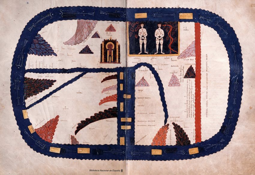
196 Patrick S. Marschner
Introduction
The manuscript 1513 of the Spanish National Library, also named »Códice de Batres«,1 was
written around 1200 in Oviedo2 and belongs to the famous Corpus Pelagianum. This manu
script is based on a compilation by Bishop Pelayo of Oviedo (died in 1153), whose main in-
tention is to emphasise the role of his diocese.3
Beginning with a geographical scheme, a specific form of a mappa mundi, described in
more detail below, the codex BNE 1513 differs in a significant respect from other manu-
scripts of the Corpus Pelagianum.4 No other Pelagian witness, especially not the two perhaps
most comparable codices, BNE 1358 and 2805, offers this kind of illustration.5 Additionally,
this map is not a map in pure form, as it also exhibits the qualities of a genealogical table,
referring to the three sons of Noah and their descendants. Its schematic layout differs con-
siderably from other forms of medieval mappae mundi.
1 Pérez de Urbel, Sampiro, 165; Galván Freile, MS. 1513, 479; Fernández Conde, Pelayo de Oviedo, 13. A completely
digitised version of this codex is provided by the Spanish National Library, accessed on 21 April 2021: bdh-rd.bne.
es/viewer.vm?id=0000005990&page=1.
2 Fernández Conde, Pelayo de Oviedo, 13 and 14 n. 5; Galván Freile, Iconografía, ornamentación y valor, 234 n. 61
and Galván Freile, MS. 1513, 494-495 date it to the early years of the thirteenth century, but also take into account
arguments for an emergence in the late twelfth century, which is also discussed by Sánchez Alonso, Crónica del
obispo, 17-18 and Barton and Fletcher, World of el Cid, 71.
3 The Corpus Pelagianum contains in particular texts that substantiate the desired leadership role of the diocese
of Oviedo. See Pérez de Urbel, Sampiro, 136-165; Fernández Conde, El Libro de los Testamentos, 50-61; Fletcher,
Episcopate, 72-74. See generally on Bishop Pelayo and the Corpus Pelagianum, Alonso Álvarez, Corpus Pelagianum;
Alonso Álvarez, Obra histórica; Alonso Álvarez, Obispo Pelayo; Jerez, Arte compilatoria pelagiana; Alonso Álvarez,
Rey Alfonso VI, 16-19; de Toro Vial, Pelayo de Oviedo, 15.
4 Madrid, BNE, 1513, fol. 1v. There has been only a little investigation of this object so far. The studies in which one
would expect to find it discussed, do not in fact address it. Destombes, Mappemondes does not refer to this map.
In his study of miniatures and further illustrations of the codex 1513, Galván Freile, MS. 1513, 483-494 does not
examine the map either. Also the extensive and versatile article of Woodward, Medieval Mappaemundi, does not
relate to this map. Equally, Pinet, Task of the Cleric does not mention it. Most recently, the scheme has been in-
vestigated by de Toro Vial, Pelayo de Oviedo, 6-7 and 20, where he transcribed and translated it into Spanish, and
Fernández Conde, Pelayo de Oviedo, 52-53.
5 Madrid, BNE, 1358 and Madrid, BNE, 2805. For more information on these manuscripts see Inventario general 4,
401-404 for the first and Inventario general 8, 365-367 for the second. In this article I define as an illustration every
graphical depiction that is not or not entirely textual, which contains maps, diagrams, miniatures etc.
medieval worlds • No. 13 • 2021 • 195-228
197                      The World Map of the Corpus Pelagianum and its Strategies of Identification

Figure 1: Geo-genealogical scheme. Madrid, BNE, MS. 1513, fol. 1v.

The map combines different ways of presenting knowledge, and the sources for this material
will be discussed here. In particular, the genealogical content of this chart is closely related
to the historiographical texts that follow in the codex BNE 1513. To what extent do the texts
and the map interact directly, and to what extent can the similarities be explained by the fact
that both use material from Isidore’s Etymologies? To start with, an overview of this codex
and its structure will be given.

                                                             medieval worlds • No. 13 • 2021 • 195-228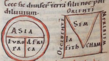
198 Patrick S. Marschner
The Composition of the Codex Madrid, BNE 1513
BNE 1513 contains further illustrated geographical, or rather meteorological, elements, a
diagram on consanguinity with respect to the degrees of kinship, historiographical texts,
transcripts of royal decrees, various council documents, and two small historical texts, each
addressing theories of time.6 In particular, the combination of historiographical texts fol-
lowing the geographical illustrations and descriptions represents a specific interaction of the
depiction of history and space in this codex.7
The illustration on folio 1v is followed directly opposite the opening by another one, a
diagram depicting consanguinities to six degrees, on fol. 2r.8 This symmetric diagram ba-
sically follows the form produced in Isidore’s Etymologies.9 As Galván Freile mentioned,
diagrams like this were not unusual in contemporary Hispania.10 Yet, it is difficult to
explain its relationship to the preceding illustration. One could speculate that on fol. 1v re-
lationships of peoples are depicted in a universal sense, whereas fol. 2r displays relation-
ships on a lower level, namely between individuals. After a short text passage explaining
the diagram of consanguinity, the next two illustrations within the codex, on fols 3r and
3v, both comprise schemes of the different winds from the cardinal directions,11 which are
also drawn from Isidorean knowledge;12 one gets the impression, therefore, that the main
correlation uniting these illustrations in the first folios of the codex is their connection
to Isidore’s Etymologies. By collecting Isidorean knowledge, Pelayo of Oviedo may have
sought to style himself as a scholar.13
6 Inventario general 4, 401-404. See also the website of the Biblioteca Nacional de España, accessed on 21 April 2021:
bdh.bne.es/bnesearch/detalle/bdh0000005990#. Galván Freile, MS. 1513, 482-483.
7 On the impossibility of investigating such an illustration in isolation from the surrounding text(s), see Müller,
Visuelle Weltaneignung, 25-26.
8 Madrid, BNE, 1513, fol. 2r.
9 Galván Freile, MS. 1513, 483; Isidore of Seville, Etymologiarum, 9.5-6, ed. Lindsay.
10 Galván Freile, MS. 1513, 483 n. 20.
11 Madrid, BNE, 1513, fol. 3r., also depicted in Galván Freile, MS. 1513, after 496 [no pagination]; Madrid, BNE, 1513,
fol. 3v.
12 Galván Freile, MS. 1513, 484; Isidore of Seville, Etymologiarum, 13.11.2-3, ed. Lindsay. The illustration on fol. 3r.
contains a possible error: the cardinal directions north and south in the inner circle are mixed up – the wind called
»Septentrio« would blow from the south while the »Auster« would blow from the north, which, in truth, is the
other way around in the medieval imagination. This has previously been mentioned by Galván Freile, MS. 1513,
484 n. 21. But there is the possibility that this depiction functions in a similar way as a planisphere from today’s
astronomy education. Such a planisphere also shows north and south interchanged as long as laid out in front of
the observer. But if one holds it above the head, the depiction turned down, the cardinal directions are correct
again. Since the illustration of winds from BNE 1513, fol. 3r from a certain point of view shows phenomena from
the sky, there is a possibility that it might have been used or at least understood like that.
13 In both of the schemes in Madrid, BNE, 1513 fol. 3r and fol. 3v the following is written in the middle: »Pelagius
episcopus me fecit.« On fol. 3v the ›fecit‹ is written out. Trans.: »I, Bishop Pelayo, made this«; All quotations from
manuscript sources are transcribed diplomatically, but with spacing regularised and abbreviations expanded in
italics. On the characteristics of Bishop Pelayo as a compiler or collector of knowledge, see the studies mentioned
above in n. 3.
medieval worlds • No. 13 • 2021 • 195-228199 The World Map of the Corpus Pelagianum and its Strategies of Identification
The presentation of history in BNE 1513 starts with texts on the creation and the aetates
mundi.14 Unsurprisingly, some content from the initial scheme, such as on the descendants
of Noah’s son Shem, reappears in these passages of biblical stories.15 They offer a genealogy
from Shem up to Ishmael and the Ishmaelites and also to the Israelites in a textual manner,
i.e. without any graphical support. It makes obvious reference to the Table of Nations.16 After
giving a brief history of the people of Israel, touching, for instance, on the stories of Moses
or David, the historical focus then turns to the Roman Empire under Octavian, mention-
ing the birth of Jesus,17 and continues with the depiction of the Roman emperors up until
Tiberius III (698-705).18 Having reached the contemporaries of the last Visigothic kings, the
compilation does not, however, go further with the historiographical texts of the Iberian
Peninsula. Instead, the historical narration gets interrupted by the biblical stories of Job,
Joseph, Moses, and the rulers of the people of Israel until Solomon.19 These passages are fol-
lowed by Jerome’s exegesis of the book of Ezekiel and further biblical genealogies.20 After a
short depiction of Jesus, Peter and Paul, as well as some accounts of persecutions against the
Christians, the historical narration then leads to Gaiseric.21 Following that, the manuscript
offers a computation of the years of the world.22
After these undoubtedly universal-historical elements, the codex contains continuous
Hispanic chronicles, beginning with Isidore’s Historia de regibus Gothorum, Vandalorum
et Suevorum,23 followed by »Redaction C« of the Chronicle of Alfonso III,24 the Chronicle of
Sampiro25 and Pelayo’s Chronicon regum Legionensium.26 After these Christian-Iberian texts,
the codex contains a version of the Liber historiae Francorum.27 Hence, the geographical
depictions, the imagination of space and phenomena within space – such as the winds – are
directly followed by history. In that manner, history and space are entangled in codex 1513.
Additionally, since the first and most prominent geographical depiction also contains ge-
nealogical elements that correlate with the content of the above-mentioned text about the
14 Madrid, BNE, 1513, fols. 4r-24r. Fernández Conde, Pelayo de Oviedo, 54-56,
15 For instance, Madrid, BNE, 1513, fol. 5r, right column: »Sem anno IIo post diluvium cum esset C duo annorum
genuit arfaxar a quo gens chaldeorum exhorta est«. Trans.: »In the second year after the Flood Sem, with one
hundred and two years, begot Arpachshad from whom sprung up the people of the Chaldeans.«
16 Genesis 10. All references to and quotations from the Bible are taken from the Vulgate. All English Bible trans
lations are taken from the Douay-Rheims Bible.
17 Madrid, BNE, 1513, fol. 11r.
18 Madrid, BNE, 1513, fol. 18r.
19 Madrid, BNE, 1513, fol. 21r.
20 Madrid, BNE, 1513, fol. 21v-22r.
21 Madrid, BNE, 1513, fol. 22r-23r.
22 Madrid, BNE, 1513, fol. 23r-24r.
23 Madrid, BNE, 1513, fols. 24r-38r. Isidore of Seville, Historia Gothorum, ed. Mommsen, 295-303. The order of the
parts of the text in the manuscript varies from the order in the edition.
24 Madrid, BNE, 1513, fols. 38v-52v. Redactio C, ed. Prelog, 70-129.
25 Madrid, BNE, 1513, fols. 52v-64r. Obviously, this is the »Pelagian version« of this chronicle. Sampiro of Astorga,
Chronica, ed. Pérez de Urbel, 275-346, left column.
26 Madrid, BNE, 1513, fols. 64r-72v; Chronicon regum Legionensium, ed. Fernández Conde, 28-37.
27 Madrid, BNE, 1513, fols.72v-101v. Apparently, it is version B according to the studies of Krusch, Fredegarii et ali-
orum chronica, 215-238.
medieval worlds • No. 13 • 2021 • 195-228200 Patrick S. Marschner
aetates mundi and at least three of the chronicles, this map interacts with the historical writ
ing in the codex. Due to the constructions of identity that can be found in both the map and
the historiographical texts, the field of historical identification will be the most important
element of this comparison.
The chronicles of Isidore, Alfonso III, Sampiro and Pelayo are also related to each other
through their contents. Beginning with the reign of Wamba, the Chronicle of Alfonso III
relates to the content of the Historia Wambae regis of Julian of Toledo,28 but is also tied to
Isidore’s Historia de regibus Gothorum, Vandalorum et Suevorum, since it is in some points
a continuation of the latter.29 While the Chronicle of Alfonso III connects to the last Visi
gothic chronicles, the eleventh-century Chronicle of Sampiro begins with precisely that part
of Iberian history that the Chronicle of Alfonso III ended with: the reign of Alfonso III.30
In the same way, the Chronicon regum Legionensium is a continuation of the Chronicle of
Sampiro.31 Accordingly, the Hispanic historiographical texts in BNE 1513 seem to mirror
continuity from the last Visigothic kings until the days of Bishop Pelayo of Oviedo.32 This
»grand narrative«33 contains an intense examination of the cultural and religious »Other«
in the Iberian Peninsula, the Arab foreign rulers, from the Chronicle of Alfonso III until the
Chronicon regum Legionensium. As will be shown below, the initial scheme on fol. 1v cor-
relates with the depiction of the »Other« in these historiographical texts. Therefore, the
scheme should also be understood through the historiographical approach.
Bearing all this in mind, the composition of BNE 1513 taken as a whole can be inter-
preted as depiction of the compilers ideas of both space and history. Both components
that shape this codex are of a universal character: the geographical and meteorological
elements refer to all parts of the (known) world, while the history that is written in BNE
1513 begins with creation, historically thematises several regions of the world, describes
the aetates mundi, and turns the focus of this universal history to the post-conquest Chris-
tian realms in the north of Hispania. This codex grasps the world in its entirety, con-
cerning both history and space. In doing so, it converges with the almost all-embracing
knowledge of Isidore’s Etymologies, which form a significant and striking component of
this manuscript. Ultimately, Bishop Pelayo of Oviedo, the compiler of this collection of
knowledge, is placed in direct succession to Isidore, as the most important bishops – as
they appear in the aforementioned chronicles as authors or protagonists – are all depict-
ed in the form of miniatures in this codex: Isidore,34 Julian of Toledo,35 the perhaps fictive
28 Historia Wambae regis, ed. Levison, 213-255; Redactio C, ed. Prelog, 70-71, for instance, contains several passag-
es and information taken from the Historia Wambae regis. They are identified and further interpreted in Prelog,
Chronik Alfons’ III., 133-137 n.13-25.
29 Bronisch, Reconquista und Heiliger Krieg, 126.
30 Casariego [Fernández-Noriega], Crónicas de los Reinos, 79; Bronisch, Reconquista und Heiliger Krieg, 159.
31 Sánchez Alonso, Crónica del obispo, 43-44; Casariego [Fernández-Noriega], Crónicas de los Reinos, 161.
32 For example, on this topic, see Jerez, Arte compilatoria pelagiana, 66-87; Fletcher, Episcopate, 72-73.
33 Concerning the justified criticism of this term as it was used in nationalistic Spanish depictions of medieval Iberian
history from the middle of the twentieth century, see Payne, Visigoths and Asturians reinterpreted, 48, 51-54.
34 Madrid, BNE, 1513, fol. 28v.
35 Madrid, BNE, 1513, fol. 38v.
medieval worlds • No. 13 • 2021 • 195-228201 The World Map of the Corpus Pelagianum and its Strategies of Identification
Sebastian,36 Sampiro of Astorga,37 and finally, Pelayo of Oviedo.38 All of them also appear in
succession in a small text passage towards the start of the codex.39 Perhaps Pelayo of Oviedo
wanted to be understood as a new Isidore, reassembling the latter’s wide-ranging knowledge.
In the following, more traces of Isidore in Pelayo’s work will be explored.
The »Geo-genealogical Scheme«, its Peculiarities, and its Sources of Knowledge
The display on BNE 1513, fol. 1v is named »Divisio hominum in terrae regionibus« (division
of the humans in the regions of the world) in the Inventario general of the Spanish National
Library,40 even though this title does not appear in the manuscript. There is no individual
denomination for this illustration. One of the latest investigators of this object, José Miguel
de Toro Vial, calls it a »Tabla con el reparto del mundo entre los patriarcas« (table with the
division of the world among the patriarchs).41 At the same time, de Toro Vial is aware of the
cartographic character of this scheme.42 Francisco Javier Fernández Conde calls it a »Cosmo
visión« (worldview) in his latest monograph.43 Indeed, the illustration on BNE 1513, fol. 1v is
a map, but it is more than that: it is also a table, a diagram, and a genealogy. Hence, in com-
bining these forms it has been described as a »geo-genealogical scheme«.44 The genealogies
basically follow Isidore’s Etymologies, which are, again, based on the book of Genesis.45
In the following I am going to approach this scheme in four ways, which, however, can-
not be strictly divided but rather merge into each other. In doing so, the somehow unique
character of this scheme and, therefore, its differentiation from other more usual forms of
medieval world maps will become clear. This discussion will reveal both its author’s ability to
combine different forms of knowledge into a complex world view, and the attempt to render
this complexity in simple forms and compressed information. It will also cast light on the
author’s strategies of structuring knowledge.
36 Madrid, BNE, 1513, fol. 43r. On the presumable fictive nature of this bishop see Gil, Chronica Hispana, 112-116.
37 Madrid, BNE, 1513, fol. 48v.
38 Madrid, BNE, 1513, fol. 64v.
39 Madrid, BNE, 1513, fol. 4r; Gil, Chronica Hispana, 112.
40 Inventario general 4, 401.
41 de Toro Vial, Pelayo de Oviedo, 5-6.
42 de Toro Vial, Pelayo de Oviedo, 6.
43 Fernández Conde, Pelayo de Oviedo, 91. Also on p. 52 n. 12 Fernández Conde calls it a »Descripción del mundo«
(description of the world) and assumes Bishop Pelayo himself being the originator of this map based on the ques-
tionable argumentation that the depictions of the winds, following this map, contain the aforementioned sentence
that Pelayo created them. See above n. 13.
44 I would like to thank Prof. Dr. Uta Heil (pers. comm., 19 June 2020) for this phrasing, which she suggested during
a webinar in which I presented an earlier version of this research.
45 de Toro Vial, Pelayo de Oviedo, 6; Isidore of Seville, Etymologiarum, 9.2.2-5, 10-14, 27, 29, 89, ed. Lindsay; Genesis 10.
medieval worlds • No. 13 • 2021 • 195-228202 Patrick S. Marschner
The Scheme as a Map
The characteristics that mark this scheme as a map46 in a contemporary and geographical
sense are several: defining the cardinal directions is one. Depicting the world with the eastern
direction on top is completely usual in medieval maps, partly due to the sun rising in the east
and partly through locating Paradise in this direction (which very likely coincides).47 Second,
the trichotomy of this scheme is a typical element of medieval world maps, which show the
three inhabited parts of the (empirically known) world, the ecumene, divided into Europe,
Asia and Africa and allocated to the sons of Noah.48 Usually, Asia is depicted as the biggest
part of the world – a point on which this map definitely differs greatly from broader medieval
traditions. In the common T-O maps, Asia occupies about fifty percent of the orbis terrae,
while Europe and Africa share the remaining space.49 The reason for Asia having only a very
small area in comparison to Europe or Africa in the map of the Corpus Pelagianum can only be
speculated upon: was the size of Asia less important for the author of the map and, therefore,
the dimensions shrunk in favour of Jerusalem, which has a dominant position and occupies
about one ninth of the map? Was the geographical information of the size of continents less
important than the genealogies that relate to each part of the ecumene for the author of this
map, and if so, why in particular should the genealogy of Shem’s descendants be the smallest
(but most closely packed)? Do these questions perhaps correlate? Does the empty area to the
west of Jerusalem represent the Mediterranean Sea50 or has the genealogy of the Semites sim-
ply not been finished and should it have instead been continued down into this field? In what
other way could this blank space, which is usually avoided in medieval maps,51 be justified?
The form of such a map may result from both a rethinking of the order of the world and
a construction of specific knowledge, e.g. political, religious or social.52 Hence, cartography
can be a language in a semiotic sense, cultural symbolism, and a social product supporting
control over spaces and facilitating the expansion of social systems.53 Therefore, a map is a
result of influences coming from contemporary imaginations, purposes of depiction, and the
combination of knowledge.54 Consequently, Christian high-medieval world maps have to be
46 Generally, there is no clear definition of what a map is, neither in a contemporary sense nor given by today’s
cartographical or geographical science. What defines a map is foremost what it expresses. What is common to all
maps is that they reduce information for the sake of easier understanding of spatial circumstances. Witt, Lexikon
der Kartographie, 301.
47 Simek, Erde und Kosmos, 59. Edson et al., Mittelalterliche Kosmos, 55; Edson and Savage-Smith, Medieval Views,
58; Podossinov, Orientierung der alten Karten, 36; von den Brincken, Mundus figura rotunda, 100; Fernández
Conde, Pelayo de Oviedo, 52.
48 Woodward, Medieval Mappaemundi, 296; Edson and Savage-Smith, Medieval Views, 50; Harvey, Mappa mundi,
21; Gautier-Dalché, Héritage Antique, 56; Weeda, Ethnic identification and stereotypes, 588. Concerning the rea-
sons of the trichotomy in Genesis 10 see Hieke, Völkertafel, 27-28, 30, and especially 32; Pinet, Task of the Cleric,
27; Fernández Conde, Pelayo de Oviedo, 52.
49 A brief overview is given in Mauntel et al., Mapping continents, 310-312.
50 Mauntel et al., Mapping continents, 329; Fernández Conde, Pelayo de Oviedo, 53.
51 von den Brincken, Ausbildung konventioneller Zeichen, 341-342; Mauntel et al., Mapping continents, 341.
52 Baumgärtner, Welt im kartographischen Blick, 527-528.
53 Harley, Maps, knowledge, and power, 278-279, 304-305; I came across these definitions through Baumgärtner,
Welt im kartographischen Blick, 528, referring to Harley, who himself built his definitions in part based on those
of Aby Warburg and Michel Foucault.
54 Baumgärtner, Welt im kartographischen Blick, 528.
medieval worlds • No. 13 • 2021 • 195-228203 The World Map of the Corpus Pelagianum and its Strategies of Identification
seen as a particular image of the world rather than as a realistic display.55 In the case of BNE
1513, fol. 1v, it is – as we will discover below – a depiction of the world’s peoples affecting
Iberian history, created by a Christian intellectual, who was aware of the transcultural situa-
tion in the Peninsula and the foreign rulers dominating major parts of the region.
The divergent proportions between the parts of the world and the square shape of this
map are the characteristics that make it somehow unique. Contemporary maps mostly have
only round, oval or at least rounded forms.56 That being said, there are several comparable
geographical depictions in contemporary manuscripts, especially as graphical additions to
Isidore’s Etymologies, that are also square instead of round. For instance, a twelfth-century
manuscript of Isidore’s Etymologies from Göttweig, now held in the Austrian National Li-
brary in Vienna, offers a square scheme, divided into three triangles, each dedicated to one
son of Noah.57 This »V-in-square map«58 is accompanied by at least three of the cardinal direc-
tions with east on top and, is therefore, from a certain perspective, similar to BNE 1513, fol. 1v.
Figure 2: T-O map and V-in-☐ map in a copy of Isidore’s Etymologies. Vienna, Österreichische
Nationalbibliothek, Cod. 67, fol. 117v.
The proportions of the spaces assigned to each of Noah’s sons in this map on Vienna, Cod. 67,
fol. 117v are almost even. Furthermore, it is positioned adjacent to a simple T-O map. Very
similar V-in-square maps – with assignments of each of the equal parts to one of Noah’s sons,
cardinal directions, orientation towards the east59 or even accompanied by T-O maps – can
be found in many regions of medieval Europe – including the Iberian Peninsula – from at
55 von den Brincken, Mappa mundi, 122.
56 von den Brincken, Mundus figura rotunda, 99-103.
57 Vienna, ÖNB, Cod. 67, fol. 117v.
58 Van Duzer, Neglected type, 278. To emphasise the shape of these maps, Van Duzer also offers the spelling »V-in-☐
map«.
59 This is somewhat tautological, since the term »orientation« originates from »oriens«, east. A different definition is
given by von den Brincken, Mappa mundi, 175, ascribing the term to the Italian language as a reference to the setting
of sails against the wind. For the characteristics of V-in-square maps in general, see Van Duzer, Neglected type, 278.
medieval worlds • No. 13 • 2021 • 195-228204 Patrick S. Marschner
least the ninth to the fifteenth centuries. In most cases, they appear as additions to copies of
Isidore’s Etymologies.60 A decidedly Iberian example of such a V-in-square map appears in an
eleventh-century copy of Beatus of Liébana’s Commentary on the Apocalypse, also embedded
in an Old Testament genealogy.61
Figure 3: V-in-☐ map in a copy of Beatus of Liébana’s Commentary on the Apocalypse. Madrid,
BNE, Vitr. 14-2, fol. 12v.
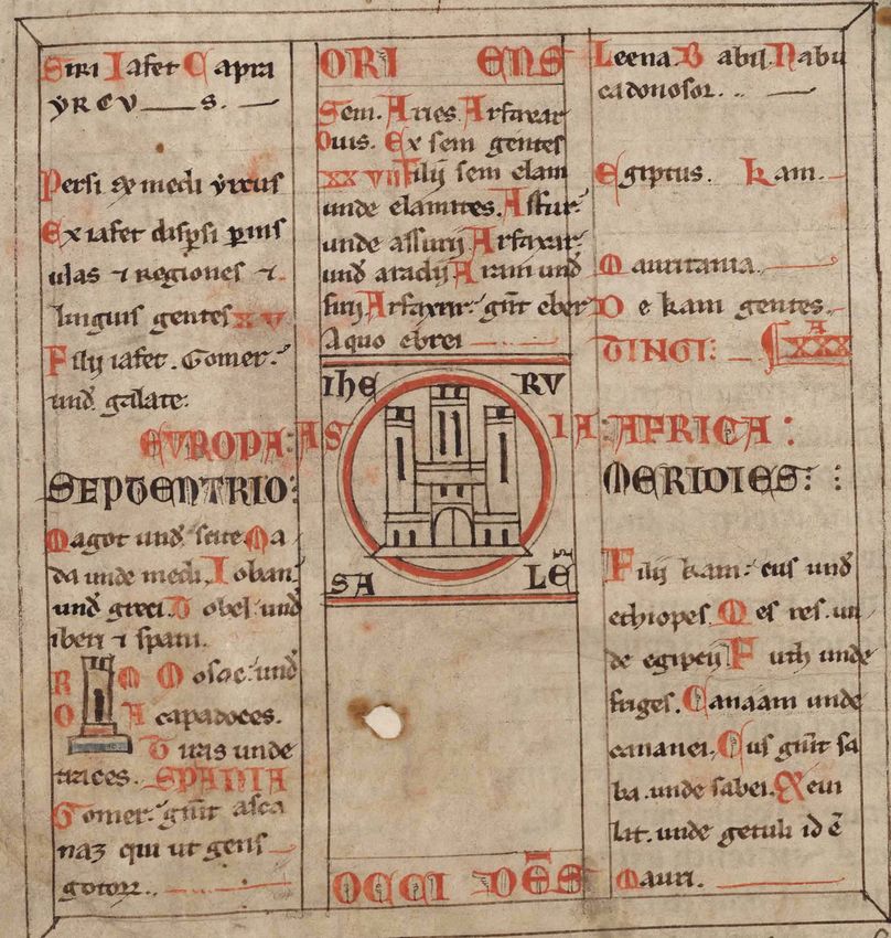
BNE, Vitr. 14-2, where we find the above illustration, contains another world map of some
size, positioned across the opening of two folios (fols 62v-63r); it follows the T-O scheme
but is somewhat rectangular rather than round. Jerusalem is not positioned in the centre
but is instead very exposed near the midpoint, the map is orientated towards the east and
contains several topographical terms such as Rome, Tarragona, Pannonia or »Mauritania
Tingitania«.62
60 Woodward, Medieval Mappaemundi, 301; Van Duzer, Neglected type, 278-280, for illustrations, see especially
293-296.
61 Madrid, BNE, Virt. 14-2, fol. 12v.
62 Madrid, BNE, Virt. 14-2, fols 62v-63r. This map and its potential tenth-century predecessor are thematised briefly
in Baumgärtner, Welt im kartographischen Blick, 531-534.
medieval worlds • No. 13 • 2021 • 195-228205 The World Map of the Corpus Pelagianum and its Strategies of Identification
Figure 4 (a-b): World map in a copy of Beatus of Liébana’s Commentary on the Apocalypse.
Madrid, BNE, Vitr. 14-2, fols 62v-63r.
One could speculate that the author of the Pelagian scheme was aware of both types of
mappae mundi and, thus, mixed them. In all probability, there was a Beatus codex in Oviedo,
containing comparable illustrations of the corresponding maps.63
Apart from the unusual dimensions of Asia and the unclear role of the empty area to the
west of Jerusalem, the map of the Corpus Pelagianum seems to follow the schematic ap-
proach of the V-in-square maps rather than that of T-O maps, albeit elements like the central
position of Jerusalem or the depiction of Rome are striking differences. The connection to
Isidorean knowledge especially supports this assessment. At the least, one could interpret
the two lines of the typical V as simply being paralleled for the sake of a more practical layout
for writing in the resulting columns.
63 Miller, Weltkarte des Beatus, 21.
medieval worlds • No. 13 • 2021 • 195-228206 Patrick S. Marschner
Returning from the mere geometric form of BNE 1513, fol. 1v to its content, the position-
ing of Jerusalem in the centre of the known world is a usual element of medieval mappae
mundi, especially of the T-O type. As the place where Jesus’ grave is located and where the
Easter event, the beginning of salvation, took place, Jerusalem was interpreted as the navel,
the centre of the world in both the spatial and the historical sense.64 Furthermore, it could
also have drawn on a passage from the book of Ezekiel that reasoned the geographical posi-
tion of Jerusalem in the centre of the world.65
Finally, the four cardinal directions and several topographic terms in the scheme are an
unequivocal sign of a map. First, there are the names of the three known parts of the world
located in each third and written in red capitals: »Europa«, »Asia« and »Africa«. In the centre
of the map, Jerusalem is the only toponym belonging to Asia. »Mauritania« and »Tingi« are
the only two terms describing a region and a city66 in Africa. Lastly, in the area of Europe,
Rome and Hispania are the only toponyms given.67 Thus, on every continent at least one
name of a city appears: Rome, Jerusalem, and Tingi. The character in which »Mauritania« is
written in the upper third of the column representing Africa seems to be an exception, since
»Roma«, »Spania«, »Europa«, »Asia«, »Africa«, and »Tingi« are written in red capitals and
»Iherusalem« also at least in capitals. All other remaining text in this scheme, except the
cardinal directions, is of the genealogical kind. Additionally, Rome and Jerusalem are the
only cities which are both named and depicted with buildings in the map. This emphasising
of these two cities is not surprising, since Jerusalem was, as mentioned above, understood
as the navel of the world and Rome represented both the caput mundi as well as the sixth
and final age of the world. From a Christian author’s point of view, then, these are the two
most important cities of the world’s history. In a historiographical sense, Jerusalem could
be understood as the turning point, the place where David and Solomon installed a divine
kingship and built the first temple and also the place where Christ died and was resurrected
and, in doing so, opened the way to the salvation of humankind, whereas Rome represents
the final age. Interpreted like this, both are symbols related to salvation and, thus, more than
mere places on earth.68 Furthermore, most of the text referring to peoples and their origin in
the map leads to the conclusion that the primary aim was the depiction of humankind, rather
than offering a display of the physical world.
64 von den Brincken, Mappa mundi, 173; Simek, Erde und Kosmos, 95-96, 104; Wolf, Jerusalem und Rom, 208-220;
Fernández Conde, Pelayo de Oviedo, 52.
65 Ezekiel 5, 5: »haec dicit Dominus Deus ista est Hierusalem in medio gentium posui eam et in circuitu eius terras«.
Trans.: »Thus saith the Lord God: This is Jerusalem, I have set her in the midst of the nations, and the countries
round about her«; Baumgärtner, Wahrnehmung Jerusalems, 272, 275, who also refers to Jerome’s influence on this
image of Jerusalem.
66 Isidore of Seville, Etymologiarum, 14.4.12 and 15.1.74, ed. Lindsay.
67 de Toro Vial, Pelayo de Oviedo, 6; Fernández Conde, Pelayo de Oviedo, 52-53.
68 Goetz, Gott und die Welt, 160, 162-163, 216; Wolf, Jerusalem und Rom, 174-186, 188-206.
medieval worlds • No. 13 • 2021 • 195-228207 The World Map of the Corpus Pelagianum and its Strategies of Identification
The Scheme as a Table
From another perspective, this geo-genealogical scheme could be interpreted as a table.69
Even though it lacks an arrangement into rows, the division into columns is obvious. Yet, it
seems that the columns do not contain a clear and exclusive subject. If the columns were
solely dedicated to Noah’s sons in the order Japheth, Shem and Cham from left to right, then
the cardinal directions, the depictions of cities and the denomination of the parts of the
world would be alien elements – at least from today’s perspective and with our definition of
»table« in mind. On the other hand, the contemporaries’ clear allocation of the continents
to Noah’s sons did not even admit the option for the author to categorise the terminology in
the scheme into »geographical« and »genealogical«. Hence, to him there was no alien ele-
ment but only an order of peoples in specific parts of the world. Thus, for the author, these
columns could very well have had a clear and specific subject.
Furthermore, the genealogical content in each column is strictly delimited from the rest,
and possible cross connections – which do exist in the Old Testament genealogies, as we will
discover below – are absent. Accordingly, the three parts of the world function as columns of
a table, especially as regards its genealogical content.
The Scheme as Genealogy
Genealogy is a way of depicting history, since its content enters the past alongside the ances-
try of persons or peoples clarifying their origins.70 If such genealogies go back to the origin
of all peoples, namely the biblical progenitors, as is the case in BNE 1513, fol. 1v, then this
form of history becomes a universal one.71 Therefore, this map is not just a depiction of the
entire inhabited world but also of the origin and history of its inhabitants. Admittedly, the
genealogical story does not go back as far as the Creation, but instead to the end of the Flood,
which is something of a second beginning of mankind’s history. The story of Noah and his
sons is a myth explaining the roots of all humans from that point in time, when mankind
was virtually recreated.72 Therefore, the scheme’s basis can not only be found in Isidore’s
Etymologies but also in Genesis 10, better known as the Table of Nations. This archetype of
»Völkergenealogie« already intended to create a spatial order of the world,73 and this function
was passed on by Isidore74 and, moreover, by those medieval scholars, who built further upon
his work.
69 de Toro Vial, Pelayo de Oviedo, 5-6.
70 Hieke, Genealogy, 391.
71 von den Brincken, Mappa mundi, 124: »Sind […] mittelalterliche Weltkarten weitgehend gewissermaßen graphi-
sche Darstellungen der Weltchroniken, des Weltverlaufs im Raume, aufgezeichnet auf einer begrenzten Fläche,
so sei es gestattet, sie […] einmal nicht vom Standpunkt der Geographie, sondern von dem der Universalhistorio
graphie zu betrachten. Geschichtsschreibung stellt Menschen in Raum und Zeit dar, Universalgeschichtsschrei-
bung sucht die Menschheit in der Gesamtheit des Raumes und der Summe der Zeit zu erfassen.« Trans.: »If me-
dieval world maps are largely quasi graphic depictions of world chronicles, of the course of the world inside space,
recorded in a limited range, it is permitted to contemplate them for once not from the perspective of geography
but that of universal historical writing. Historical writing depicts humans in space and time, while universal his-
tory tries to conceive of mankind in the entirety of space and in the summa of time.«
72 Hieke, Völkertafel, 24-25.
73 Hieke, Völkertafel, 24 and 30-31, concerning the uniqueness of the Table of Nations among religious texts of the
antique Middle East and in comparison to ancient Greek genealogies.
74 Merrills, Geography and memory, 51.
medieval worlds • No. 13 • 2021 • 195-228208 Patrick S. Marschner
In one of her older studies, Anna-Dorothee von den Brincken did not take into account that
genealogies can be a part of universal history75 although she identified the genre of encyclopae-
dic historical writing as such, among which she numbered Isidore’s Etymologies.76 Additionally,
she reminds the reader of the continuing connection made between encyclopaedic universal
chronicles and maps in medieval manuscripts. In particular, the allocation of the world’s parts
to Noah’s sons has often been a cause of geographical excurses, presumably reasoned for the
emergence of diversity out of unity.77 The scheme of BNE 1513 seems to be just such a case. An
opening element of this manuscript comprises an Isidorean-encyclopaedic prologue to Iberian
history, with the genealogies as they appear in the scheme being, essentially, taken from the
ninth book of his Etymologies.78 In the area – or column – of Europe, the descendants of Japheth
are listed up until the people of the Goths, following Isidore’s text with only minor variations:
Madrid, BNE, 1513, fol. 1v Isidore, Etymologiarum 9.2.26-32, ed.
Lindsay
»Siri, Iafet, Capra| yreus | Persi et medi, yi- »Filii igitur Iaphet septem nominantur : Go-
rus | Ex iafet dispersi per ins|ulas et regiones mer, ex quo Galatae, id est Galli. Magog, a quo
et | linguis gentes XV | Filii iafet. Gomerus | arbitrantur Scythas et Gothos traxisse origi-
unde galate | Magot [sic!] unde scite. Ma|da nem. Madai, a quo Medos existere putant. Ia-
unde medi. Iobanus | unde greci. Tobel unde van, a quo Iones, qui et Graeci. Vnde et mare
| iberi et spani | Mosacus unde | capadoces | Ionium. Thubal, a quo Iberi, qui et Hispani;
Tiras unde | traces | Gomerus genuit asca|naz Jicet quidam ex eo et Italos suspicentur. Mo-
qui ut gens | gotorum« soch, ex quo Cappadoces. Vnde et urbs apud
eos usque hodie Mazaca dicitur. Thiras, ex
quo Thraces; quorum non satis inmutatum
vocabulum est, quasi Tiraces. Filii Gomer,
nepotes Iaphet. Aschanaz, a quo Sarmatae,
quos Graeci Rheginos vocant.«
75 von den Brincken, Mappa mundi, 125-126.
76 von den Brincken, Mappa mundi, 126.
77 von den Brincken, Mappa mundi, 130.
78 de Toro Vial, Pelayo de Oviedo, 6-7.
medieval worlds • No. 13 • 2021 • 195-228209 The World Map of the Corpus Pelagianum and its Strategies of Identification
Syrians, Japheth, Capra [?], Yrius [?]; Persi- Seven sons of Japheth are named: Gomer,
ans and Medes, Yirus; From Japheth spread from whom sprang the Galatians, that is, the
fifteen languages and peoples to the isles Gauls (Galli). Magog, from whom people think
and regions; Sons of Japheth. Gomer, from the Scythians and the Goths took their origin.
whom [descent] the Galatians; Magot, from Madai, from whom people reckon the Medes
whom [descent] the Scyths; Madai, from came to be. Javan, from whom the Ionians, who
whom [descent] the Medes; Javan, from are also the Greeks – hence the »Ionian« Sea.
whom [descent] the Greeks; Tubal, from Tubal, from whom came the Iberians, who are
whom [descent] the Iberians and Spani- also the Spaniards, although some think the
ards; Mosac, from whom [descent] the Ca- Italians also sprang from him. Meshech, from
padocians; Tiresias, from whom [descent] whom came the Cappadocians; hence to this
the Thracians. Gomer begat Ashkenaz, from day a city in their territory is called Mazaca.
whom [descent] the people of the Goths.79 Tiras, from whom the Thracians; their name is
not much altered, as if it were Tiracians. Then
the sons of Gomer, the grandsons of Japheth.
Ashkenaz, from whom descended the Sarmati-
ans, whom the Greeks call Rheginians.80
79 Madrid, BNE, 1513, fol. 1v. I left out the toponyms and cardinal direction listed in this space of the illustration.
Concerning the reading of the manuscript, compare de Toro Vial, Pelayo de Oviedo, 20 and, partially, Fernández
Conde, Pelayo de Oviedo, 53 n. 14.
80 Isidore of Seville, Etymologiarum, 9.2.26-32, ed. Lindsay; trans. Barney et al., Etymologies, 193. On the background
of the story of Tubal, its underlying form in Isidore’s Etymologies and its appearance in the thirteenth century, see
Díaz [Martínez], Mito godo, 58-59.
medieval worlds • No. 13 • 2021 • 195-228210 Patrick S. Marschner
Compared to Isidore’s very long genealogy of the descendants of Shem,81 the text in the
middle column of the Pelagian scheme is very short. But this passage also basically follows
the Etymologies:
Madrid, BNE, 1513, fol. 1v Isidore, Etymologiarum, 9.2.2-5, ed. Lindsay
»Sem. Aries. Arfaxar | Ouis. Ex sem gen- »Gentes autem a quibus divisa est terra, quin-
tes | XXVII. Filii sem elam unde elamites. decim sunt de Iaphet, triginta et una de Cham,
Assurus | unde assurii; Arfaxarus | unde viginti et septem de Sem, quae fiunt septua-
aradii [sic!]; Aram unde | sirii. Arfaxarus ginta tres, vel potius, ut ratio declarat, sep-
genuit eber | a quo ebrei« tuaginta duae; totidemque linguae, quae per
terras esse coeperunt, quaeque crescendo
provincias et insulas inpleverunt. Filii Sem
quinque singulariter gentes singulas procrea-
verunt. Quorum primus Elam, a quo Elamit-
ae principes Persidis: secundus Assur, a quo
Assyriorum pullulavit imperium: tertius Ar-
phaxat, a quo gens Chaldeorum exorta est:
quartus Ludi, a quo Lydii: quintus Aram, a
quo Syri, quorum metropolis fuit Damascus.
Filii Aram, nepotes Sem, quattuor: Hus et Ul
et Gether et Mes. Hus Traconitidis conditor,
qui inter Palaestinam et Coelesyriam tenuit
principatum, unde fuit Iob, secundum quod
scriptum est [Hiob 1, 1]: ›Vir erat in terra Hus‹:
secundus Ul, a quo Armenii: tertius Gether, a
quo Acarnanii sive Curiae: quartus Mes, a quo
sunt hi qui vocantur Maeones. Posteritas Ar-
phaxat filii Sem; Heber nepos Arphaxat, a quo
Hebraei; Iectam filius Heber, a quo Indorum
orta est gens; Sale filius Iectam, a quo Bactria-
ni, licet eos alii Scytharum exules suspicantur«
81 Already in Genesis 10, Shem has the longest list of descendants. Hieke, Völkertafel, 30.
medieval worlds • No. 13 • 2021 • 195-228211 The World Map of the Corpus Pelagianum and its Strategies of Identification
Shem. Aries. Arpachshad; Ovis. From Now, of the nations into which the earth is
Shem [descent] twenty seven peoples; the divided, fifteen are from Japheth, thirty-one
sons of Shem: Elam, from whom [descent] from Ham, and twenty seven from Shem,
the Elamites; Ashur, from whom [descent] which adds up to seventy three – or rather,
the Assyrians; Arpachshad, from whom as a proper accounting shows, seventy two.
[descent] the Arades [Arabs?]; Aram, from And there are an equal number of languages,
whom [descent] the Syrians; Arpachshad which arose across the lands and, as they in-
begat Eber, from whom [descent] the He- creased, filled the provinces and islands. The
brews.82 five sons of Shem each brought forth indivi-
dual nations. The first of these was Elam, from
whom descended the Elamites, princes of the
Persians. The second Asshur, from whom
sprang the empire of the Assyrians. The third
Arpachshad, from whom the nation of the
Chaldeans arose. The fourth Lud, from whom
came the Lydians. The fifth Aram, from whom
descended the Syrians, whose capital city
was Damascus. There are four sons of Aram,
the grandsons of Shem: Uz, Hul, Gether, and
Mash. Uz was the founder of Trachonitis – a
principate between Palestine and Celesyria
– from which came Job, as it is written (Job
1:1): ›There was a man in the land of Uz.‹ The
second, Hul, from whom came the Armeni-
ans. The third, Gether, from whom came the
Acarnanians or Curians. The fourth Mash,
from whom descended those who are called
Maeones. The posterity of Arpachshad the son
of Shem follows. The grandson of Arpachshad
was Heber (i.e. Eber), from whom descen-
ded the Hebrews. The son of Eber was Joktan,
from whom the nation of the Indians arose.
The son of Joktan was Sheleph, from whom
came the Bactrians – although others suspect
that these were Scythian exiles.83
82 Madrid, BNE, 1513, fol. 1v; see again de Toro Vial, Pelayo de Oviedo, 20.
83 Isidore of Seville, Etymologiarum, 9.2.2-5, ed. Lindsay; trans. Barney et al., Etymologies, 192.
medieval worlds • No. 13 • 2021 • 195-228212 Patrick S. Marschner
The same is true of the right-hand column, representing the descendants of Cham, populat-
ing Africa:
Madrid, BNE, 1513, fol. 1v Isidore, Etymologies, 9.2.10-14, ed. Lindsay
»Leena. Babil[onia/ones]. Nabu|cadonosor. »Filii Cham quattuor, ex quibus ortae sunt
| Egiptus. Kam. | De Kam gentes | XXXA | gentes haec: Chus, a quo Aethiopes progeniti;
Filii Kam: cus unde | ethiopes. Mesres Mesraim, a quo Aegyptii perhibentur exorti.
un|de egiptii. Futh unde | friges. Canaam Phut, a quo Libyi. Vnde et Mauretaniae flu-
unde | cananei. Cus genuit sa|ba unde sabei. vius usque in praesens Phut dicitur, omnis-
Heui|lat unde getuli id est Mauri« que circa eum regio Phuthensis. Chanaam,
a quo Afri et Phoenices et Chananaeorum
decem gentes. Item ex nepotibus Cham filii
Chus, nepotes Cham sex. Filii Chus: Saba et
Hevila, Sabatha, Rhegma, Seba, Cuza. Saba, a
quo progenili et appellati Sabaei, de quibus
Vergilius (Georg. 2, 117): Solis est thurea virga
Sabaeis. Hi sunt et Arabes«
Leena. Babylon. Nebuchadnezzar. Egyptus. There were four sons of Ham, from whom
Cham. From Cham [descent] thirty [eigh- sprang the following nations. Cush, from
ty] peoples. The sons of Cham: Chus, from whom the Ethiopians were begotten. Mes-
whom [descent] the Ethiopians; Mizraim, raim (i.e. Egypt), from whom the Egyptians
from whom [descent] the Egyptians; Phut, are said to have risen. Put, from whom came
from whom [descent] the Phrygians; Cana- the Libyans – whence the river of Mauretania
an, from whom [descent] the Canaanites; is called Put still today, and the whole region
Chus begat Saba, from whom [descent] the around it is called Puthensis. Finally Canaan,
Sabaeans; Hevilat, from whom [descent] from whom descended the Africans and the
the Getules, who are the Moors.84 Phoenicians and the ten tribes of Canaanites.
Again, the sons of Cush, grandsons of Ham –
the grandchildren of Ham were six. The sons
of Cush: Saba (i.e. Seba), Havilah, Sabtah,
Raamah, Seba, and Cuza. Saba, from whom
the Sabaeans were begotten and named, con-
cerning which Vergil (Geo. 2.117): The bough
of frankincense is the Sabaeans’ alone. These
are also the Arabians.85
84 Madrid, BNE, 1513, fol. 1v. I, again, renounced geographic or topographic text in this area of the scheme; de Toro
Vial, Pelayo de Oviedo, 20.
85 Isidore of Seville, Etymologiarum, 9.2.10-14, ed. Lindsay; trans. Barney et al., Etymologies, 193.
medieval worlds • No. 13 • 2021 • 195-228213 The World Map of the Corpus Pelagianum and its Strategies of Identification
As will be discussed below, some of the ethnonyms from this Isidorean genealogy play an
important role in the depiction of Iberian history in the chronicles following the map, in the
later parts of BNE 1513. Hence, this map contains a genealogy, correlating with Christian-
Iberian historical writing and its chronicler’s identification of the cultural and religious
»Other«, the foreign rulers in the Iberian Peninsula. It connects representations of ethnicity
with geographical imaginations.86
The Scheme as a Diagram
»A diagram is the commonest form of mapping. Everybody creates a map in diagrammatic
style for one reason or another – ruthlessly selecting only the essential topographical detail
and reducing direction to straight or boldly curved lines – if only to guide visitors to their
destination. Not everyone, though, recognises that their scribbles are a form of mapping, or
that the simple schematic figures they see in books are maps cleverly designed for a specific
purpose – that of instant and unambiguous communication between individuals familiar
with the subject under discussion.«87 Following Catherine Delano-Smith’s argument, the
scheme from the Corpus Pelagianum can be seen as a paragon for a diagram, since it reduc-
es geographical information to a minimum to achieve a trichotomy in the depiction of the
world, thereby enabling the inclusion of a universal genealogy, leading from the Flood to
the author’s present. The depicted order is a result of generalisation.88 Hence, this scheme
persuades the beholder of an even clearer order for the world, its history and its inhabitants
than any textual description of the very same subject could. This is reasoned by its clear
and almost simple appearance, while simultaneously offering complex meanings89 that can
be realised through abstraction.90 Thus, a scheme like the one in BNE 1513 is a concept of
knowledge transformation and conservation91 as well as a model of an imagined reality of the
world.92 This model becomes established for the beholder through its pictoriality.93
86 Weeda, Ethnic identification and stereotypes, 591.
87 Delano-Smith, Maps as diagrams, 32.
88 Meynen, Flache Blicke, 49. Müller, Formen des Anfangs, 93-94 explains that to understand the world one had to
abandon its manifest appearance in favour of geometry. Hieke, Völkertafel, 24 calls this »Bewältigung von Kom
plexität«, the overcoming of complexity, but refers to the genealogy in Genesis 10 itself, that is to the ethnic com-
plexity rather than to the geographical, although it is equally applicable to both. Concerning the spatial order of
knowledge in Isidore’s Etymologies and their principle of simplification, see Merrills, Geography and memory, 61-62.
89 Haug et al., Diagramme im Gebrauch, 263; Tanneberger, Visualisierte Genealogie, 531: »Sichtbares ist tendenziell
leichter zu vermitteln und eher glaubhaft zu machen.« Trans.: »Visible things tend to be easier to communicate
and more believable.«
90 Meynen, Flache Blicke, 40, 42.
91 Haug et al., Diagramme im Gebrauch, 265.
92 Mahr and Wendler, Bilder zeigen Modelle, 191, 194.
93 Mahr and Wendler, Bilder zeigen Modelle, 200.
medieval worlds • No. 13 • 2021 • 195-228214 Patrick S. Marschner
The contours of BNE 1513, fol. 1v build the framework in which the text was positioned.
Hence, two fields of knowledge interact in this scheme, spatial order and genealogy.94 Further
more, the field of genealogy can be subdivided into identification and history, due to its char-
acter as a discipline that looks back into history to identify contemporaries. Consequently,
at a first glance this geo-genealogical scheme seems very simple, but this reduction leads
to a complex abstraction and combination of different fields of knowledge95 and is, thus, an
impressive intellectual assessment that combines at least four ways of depicting knowledge.
Strategies of Identification and the Interaction with Historical Writing
Self-identification
Even though the Visigothic kingdom ceased to exist in 711 and its territory came under Arab
rule during the first decades of the eighth century, Christian Iberian authors, especially those
in Asturias, referred to themselves as Goths.96 Accordingly, the cartographer’s »own« people
in this geo-genealogical scheme are identified as the descendants of Japheth, since the gens
gotorum is the final ethnonym in the northern, i. e. European line of ancestry. Furthermore,
this ethnonym is positioned near the toponym Spania. From a certain point of view, one
could argue that this gens gotorum is now presented as the spearhead of the Roman Empire,
understood as the final age of the world, due to the position of this ethnonym near the il-
lustration of this city.97 Therefore, the cartographer’s own people in this scheme could even
represent the focus of salvation history, although they are not located in the centre.
In addition to the imitation of Isidore’s ninth book of the Etymologies, this Japhethan ge-
nealogy contains another Isidorean detail, which was overlooked or, at least, not further in-
vestigated by de Toro Vial, when he translated this geo-genealogical scheme.98 Directly under
the term Septentrio, the genealogy continues with the name »Magot«. It seems almost cer-
tain, that the biblical figure or people of Magog is meant here, yet the author of the scheme
definitely wrote it with final »t« as »Magot« instead of the more usual final »g«, for »Magog«.
94 This kind of entanglement may be compared with the structure of textiles, being the basis of building an object. In
our case the scheme’s shape comprises a specific interaction of form and text, as well as textual array. Schneider,
Diagramm und bildtextile Ordnung, 10-11.
95 Pinet, Task of the Cleric, 24.
96 The innumerable studies on this field cannot be listed here. In order not to extend the list of studies used for this
article even more, I refer to already cited works, in which this subject has already been thematically addressed:
Prelog, Chronik Alfons’ III., 151 n. 84; Bronisch, Reconquista und Heiliger Krieg, 91, 125, 154.
97 See above, 197.
98 de Toro Vial, Pelayo de Oviedo, 20.
medieval worlds • No. 13 • 2021 • 195-228215 The World Map of the Corpus Pelagianum and its Strategies of Identification
This presumably deliberate misspelling triggers, or rather stresses, the reference to Isidore’s
identification of the Goths as descendants of Magog, due to the similar sound in the final
syllable of the latter.99 Hence, the author’s »own« people is traced back to a biblical origin.
After Isidore and, furthermore, after the Arab conquest of the Iberian Peninsula, this identi-
fication of the Goths continues, as can be seen in examples form the ninth-century Asturian
chronicles,100 or in this geo-genealogical scheme.
The historical connection drawn between the last Visigoths and the Asturian kingdom
is, thus, also part of the redaction of the Chronicle of Alfonso III, which is also part of the
manuscript BNE 1513. It refers to the fall of the Visigothic kingdom, the flight of the Goths
into Frankish and Asturian regions, and the famous dialogue between the rebel Pelayo (not
to be mixed up with Bishop Pelayo of Oviedo) and the collaborator Bishop Oppa before the
depiction of the battle of Covadonga, in which Pelayo is confronted with the idea of restoring
the (Visi)Gothic armies against the foreign rulers.101
Identification of the Cultural and Religious »Other«
The Chronicle of Alfonso III, including redaction C as it appears in BNE 1513, offers a va-
riety of synonymous ethnonyms concerning the foreign rulers of the Iberian Peninsula.102
The foreign rulers are named »Saracens«103, »Arabs«104, »Ishmaelites«105, and »Chaldeans«106.
Additionally, the Calif of Damascus is once referred to as a »Babylonian king«.107 None of
these ethnonyms appears in the geo-genealogical scheme – at least not obviously. But in
connection with Isidorean knowledge, it is possible to ascribe them to a specific son of Noah.
99 Isidore of Seville, Historia Gothorum, ed. Mommsen, 268: »Gothorum antiquissimam esse gentem [certum est]:
quorum originem quidam de Magog Iafeth filio suspicantur a similitudine ultimae syllabae […]«; Trans. Donini
and Ford, History of the Kings, 3: »It is certain that the Goths are a very old nation. Some conjecture from the simi-
larity of the last syllable that their origin comes from Magog, son of Japhet […]«; Isidore of Seville, Etymologiarum,
9.2.89, ed. Lindsay: »Gothi a Magog filio Iaphet nominati putantur, de similitudine ultimae syllabae, quos veteres
magis Getas quam Gothos vocaverunt; gens fortis et potentissima, corporum mole ardua, armorum genere terri-
bilis. De quibus Lucanus (2, 54): Hinc Dacus premat inde Getes occurrat Iberis«; trans. Barney et al., Etymologies,
197: »The Goths are thought to have been named after Magog, the son of Japheth, because of the similarity of the
last syllable. The ancients called them Getae rather than Goths. They are a brave and most powerful people, tall
and massive in body, terrifying for the kind of arms they use. Concerning them, Lucan (Civil War 2.54): Let here a
Dacian press forward, there a Getan (Getes) rush at the Iberians.«
100 Marschner, Depiction of the Saracen, 218-221 and 219 n. 11 for the identification of the Goths as Gog already un-
dertaken by Ambrose, with a rather negative interpretation.
101 Madrid, BNE 1513, fols 43v, 45r; Redactio C, ed. Prelog, 76, 81.
102 Concerning the interpretation of these ethnonyms, their synonymous meaning, and the development of their
use in Christian-Iberian historical writing see Marschner, Familiar stranger. Since the meaning of these denomi-
nations has been investigated in this article and, further on until the Christian-Iberian historical writing of the
twelfth century, in another article, Marschner, Development of ethnic terminologies, I will not go into detail here
and rather just name the different ethnonyms that appear. Furthermore, I will interpret them concerning their
relation to the geo-genealogical scheme and only as far as necessary in relation to the further medieval Iberian
identification discourse, since this is already the subject of the aforementioned articles.
103 For instance, Madrid, BNE 1513, fols 45r, 51r; Redactio C, ed. Prelog, 80, 85, 100, 103
104 For instance, Madrid, BNE 1513, fols 43v, 45r, 46r, 47v; Redactio C, ed. Prelog, 76, 81, 88.
105 For instance, Madrid, BNE 1513, fols 45r, 47v; Redactio C, ed. Prelog, 81, 88.
106 For instance, Madrid, BNE 1513, fols 45v-46r, 50r, 51r, 51v-52v; Redactio C, ed. Prelog, 82-83, 99, 102, 104-105,
107-108.
107 Madrid, BNE 1513, fol. 43v; Redactio C, ed. Prelog, 76.
medieval worlds • No. 13 • 2021 • 195-228You can also read