TOMMY THOMPSON PARK MASTER PLAN DESIGN PROJECT APRIL 2002 - TORONTO REGION CONSERVATION AUTHORITY
←
→
Page content transcription
If your browser does not render page correctly, please read the page content below
TOMMY THOMPSON PARK
       MASTER PLAN DESIGN PROJECT
               APRIL 2002
            TORONTO REGION CONSERVATION AUTHORITY
                       in collaboration with
        UNIVERSITY OF GUELPH LANDSCAPE RESEARCH GROUP

i
EXECUTIVE SUMMARY

During the summer of 2001 students and faculty in the Landscape Research Group at the University of Guelph worked with staff of
the Toronto Region Conservation Authority, Environmental Services Section to carry out a five-part study of Tommy Thompson
Park.

The five parts included:
1. Updating the existing Master Plan;
2. Developing new gateway and park entrance concepts;
3. Preparing plans for the Cell II wetland;
4. Preparing plans for park trails, and
5. Developing concept plans for a visitor and interpretive centre.

Significant data about the Park's plants, birds, fish and animals has been collected over the years. This information has now been
plotted on new maps and the data stored in a digital format for easy reference. This base line information will assist the Authority
staff as they participate in the City of Toronto’s waterfront planning and decision making process.

To enhance the visibility and sense of arrival at the Park gateway and entrance, concepts were prepared. The concepts include a
“green” Leslie Street corridor from Unwin Avenue to Lakeshore Boulevard. Two concepts have been described in the report and in
each case the baseland area is defined as the land from the Ashbridge’s Bay Sewage Treatment Plant to the Hearn Station
discharge channel and south from the Ship Channel. The analysis of the Park Master Plan indicates that there is virtually no space
in its current configuration to allow an appropriately scaled entrance to be developed. In addition, the biophysical data reveals that
there is significant wildlife habitat in the baseland area that is integrally related to the Park. The land is currently zoned as Green
Space and in the broad context of the waterfront green system; it should be integrated into Tommy Thompson Park.

Concept One is called the Ecological Concept and it is recommended as the preferred scheme. It offers the greatest contiguous
land connection to the Park and reinforces the Park’s public urban wilderness philosophy most effectively. This concept has a small
visitor and interpretive centre, a new gateway, limited parking and immediate access to the parks trail systems and varied habitats.
New Martin Goodman trail connections are proposed to Ashbridge’s Bay and the North Shore Park. Passive recreation activities
consistent with the goal to protect and enhance the natural qualities of this Point Pelee of Toronto are proposed.

Concept Two is called the Ecological-Cultural Concept and it recognizes the various proposals that would include a substantial
Portland residential population within close walking proximity to Tommy Thompson Park. The ecological integrity of the baseland

                                                                          Tommy Thompson Park         Master Plan Design Project     ii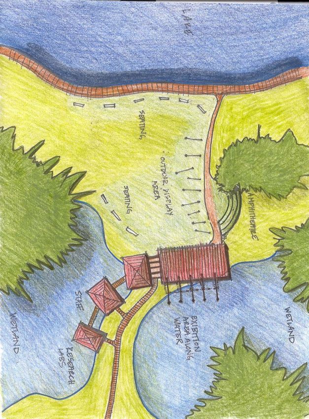
would be protected in this concept, however, other compatible active and passive recreational and cultural uses would be
integrated into the Visitor and Interpretive Centre.

For each baseland scheme, a conceptual plan for the Visitor and Interpretive Centre is proposed. The buildings are modest in
scale, would exemplify sustainable design, and fit into the ecological context of the Park. They are designed to be used on a
seasonal basis and to accommodate a variety of user groups. The buildings will contain washrooms, other convenience facilities,
an interpretive area, park staff offices, and storage rooms.

Based on air photo analysis and on the ground surveys, a composite trails plan was prepared. A hierarchy of trails and paths is
proposed based on site specific and biological sensitivities, seasonal uses, recreation types, significant views and the need for
construction and security access.

                                                                             Now that Cell 2 has reached its fill capacity, there is
                                                                             an opportunity to create new wetland habitats,
                                                                             based on the success of Triangle Pond and
                                                                             experience gained in Cell 1 design process.
                                                                             Detailed research studies were carried out to
                                                                             determine the physical and ecological requirements
                                                                             for this wetland. Several concepts were prepared
                                                                             for review by staff and the preferred concept has
                                                                             been described in the report.

                                                                             Tommy Thompson Park is one of the most unique
                                                                             ecological and recreation areas in North America.
                                                                             The material prepared in this study and
                                                                             documented in this report will be of great assistance
                                                                             to the Authority as it participates in the exciting new
                                                                             proposals to make Toronto's waterfront green,
                                                                             beautiful and connected. From the Don River and
                                                                             other valley tributaries and greenways in the north,
                                                                             to its adjacent open spaces and parks on the east
                                                                             and the west, the already significant ecological role
                                                                             of Tommy Thompson Park will become increasingly
                                                                             important.

                                                                       Tommy Thompson Park        Master Plan Design Project      iii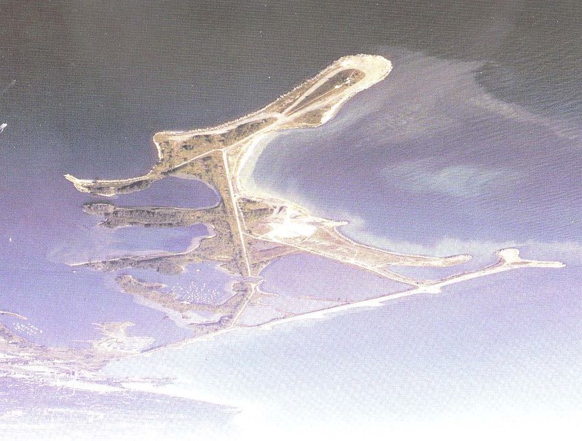
TABLE OF CONTENTS

1.0 Introduction
        1.1 Terms of Reference
        1.2 Landscape Research Group Team

2.0 Context

3.0 Tommy Thompson Park Master Plan

4.0 Gateway Experiences
       4.1 Methodology
       4.2 Interface with the City
       4.3 Tommy Thompson Baseland
       4.4 Ecological Concept
       4.5 Ecological-Cultural Concept

5.0 Cell 2 Wetland Concept

6.0 Park Trails

7.0 Visitor and Interpretive Centre
       7.1 Ecological Approach
       7.2 Eco-Cultural Approach

8.0 Summary

9.0 Appendices
      9.1 Appendix I: Cell 2 Report
      9.2 Appendix 2: Interpretive Facility Report

10.0 Bibliography

                                                     Tommy Thompson Park   Master Plan Design Project   iv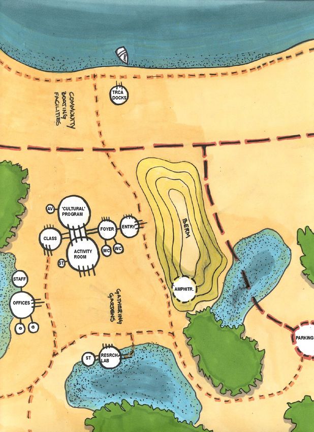
1.0 INTRODUCTION

The purpose of this report is to summarize the work completed for Tommy Thompson Park by the Landscape Research Group (LRG2)
at the University of Guelph. This work was commissioned by the Toronto and Region Conservation Authority (TRCA) in May of 2001 to
assist staff in the compilation and summarization of the substantial field data they had obtained over the years. The work undertaken
by the LRG2 used the Authority's 1988 Master Plan with the 1992 revisions and policies as the basis for their work.

During the process of developing this report, regular meetings were held with members of the TRCA. We want to give special
acknowledgement to Brian Denney, Larry Field, Gord MacPherson, Tamara Chipperfield, Ralph Toninger, Nancy Gaffney and Scott
Jarvie whose knowledge and assistance was invaluable during the preparation of this work. In addition, an all day visioning session
was held with TRCA staff involved with outdoor education and the administration and management of visitor centres. Their insight was
invaluable in providing guidance on the economic and operational issues faced by the Authority.

On behalf of the students and faculty of the University of Guelph, we wish to thank the Toronto and Region Conservation Authority for
the opportunity to participate on this important study. Tommy Thompson Park has a very special place on Toronto's waterfront and
has become a location where people from all walks of life can find recreation, relief and sanctuary. It is our hope that the work we have
completed will be of continual assistance to the Authority as a key partner in shaping the evolving waterfront plans. The ecological
philosophy and principles that are the cornerstones of the master plan provide a sound and necessary basis for ensuring the
continued vitality of the Park’s land and water areas.

                                                                          Tommy Thompson Park          Master Plan Design Project      1
1.1 TERMS OF REFERENCE

The Landscape Research Group Terms of Reference included the following five areas:

1.0   Update the existing Tommy Thompson Park Master Plan;
2.0   Develop a new gateway/park entrance concept;
3.0   Prepare plans for the Cell II wetland;
4.0   Prepare plans for park trails and signage;
5.0   Develop concept plans for a visitor and interpretive center.

1.2 LANDSCAPE RESEARCH GROUP TEAM

The following LRG2 staff participated throughout the preparation of this work.

Landscape Architecture Students and Faculty - University of Guelph
Luke Harris
Ryley Thiessen
Shelagh Bridgwater
Sue McCook
Trevor Schmidt
Robert Boraks
Walter Kehm

Environmental Science - University of Guelph
Krystyna Kopecki

Architecture Students and Faculty - University of Waterloo
2nd Year Architecture Studio
Mario Pistone
Nadia Lawrence
Michelle Xuereb

                                                                           Tommy Thompson Park   Master Plan Design Project   2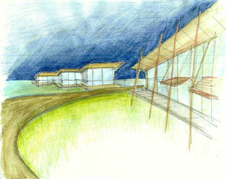
2.0 CONTEXT

There have been several waterfront initiatives undertaken in Toronto over the past two years that have the potential to substantially
influence Tommy Thompson Park and its environs. It was prudent for the Authority to review the Master Plan to assess the implications
of these initiatives. Specifically, Toronto Waterfront Revitalization Task Force Report (Fung Report), Olympic bid, and the City's
"Making Waves" reports that were developed without consideration for Tommy Thompson Park and The TRCA thought it was important
that we present our view of what should occur in that area. In addition, the Ashbridge’s Bay Sewage Treatment Plant Site Design
Project was commissioned, and consultants conducted surveys and community meetings. These lands and the baseland area at the
entrance to Tommy Thompson Park south of Leslie Street and Unwin Avenue had been identified in the Master Plan to be of special
significance. To undertake this work, the Authority had to compile their substantial natural science database to include field notes of
several years of bird, animal and fish species, new mapping and cultural conditions. This information was gathered and is now plotted
in digital form providing the Authority with the most up to date and accurate information from which surrounding changes and plans
can be assessed.

                                                                         Tommy Thompson Park          Master Plan Design Project      3
3.0 TOMMY THOMPSON PARK MASTER PLAN

The TRCA approved and adopted the Master Plan for the Park in 1995. The policy of maintaining the park as an urban wild area has
provided the guiding direction for the work undertaken by the LRG2. A key goal of this plan was to practice conservation by design.
This is defined as the purposeful act of planning and designing for a variety of wildlife habitats to assist in restoring rare, endangered or
significant plant and animal species (Toronto and Region Conservation Authority, 2000). The realization of the proposed Cell 2 wetland
design, the layout of trails and the habitat regeneration proposals for the baseland were guided by these principles. The policy of not
allowing vehicular traffic in the Park has continued in order to preserve the urban wild ideal. Low intensity activities can continue to be
provided including walking, bird watching, recreation biking and roller blading through the design of the proposed trail and path
system. The original Master Plan has served the Authority well because of the strategic position of Tommy Thompson Park on the
Toronto waterfront green system. An evaluation of all the recent proposals for waterfront development reveals that the Park remains
one of the few places where people can experience nature on a grand scale in a naturally evolving state. It provides a truly green
experience and deserves the name of the Point Pelee of Toronto.

                                                                            Tommy Thompson Park           Master Plan Design Project       4
4.0 GATEWAY EXPERIENCES

The term ‘gateway’ is used in its broadest definition to describe the experiences of arrival to, and departure from, a unique place along
the Toronto Waterfront. Tommy Thompson Park is an extraordinary place because it is home to a variety of flora and fauna, and as
such it deserves special attention and respect from visitors. It is important that the distinctiveness of the Park is revealed prior to
entering the heart of the Spit. Properly designed gateway experiences will create a sense of wonder and establish the pace at which
the Park can be explored.

4.1 METHODOLOGY

The design team made use of previous site studies, aerial photographs and mapping, consultation with the TRCA and City of Toronto
staff, as well as numerous site visits in order to gain an understanding of the baseland area and Tommy Thompson Park. From this
information LRG2 produced as many as eleven concepts illustrating the base of Tommy Thompson Park and how it would
accommodate various program options. With continued consultation with the TRCA, focus was then given to two concepts: an
Ecological Concept, which most closely follows the policy of the 1992 Master Plan; and an Ecological Cultural Concept, which address
the possibilities of an immediate urban residential context.

4.2 INTERFACE WITH THE CITY

Rather than introduce Tommy Thompson Park as a guarded sanctuary, even though its distinctiveness could call for such an
approach, LRG2 and the TRCA believe there were better opportunities to expand on the green linkages along the Toronto waterfront.
The presence of the Park could extend as far as Lake Shore Boulevard to the north, and include green edges along the Ship Channel
and the Ashbridge’s Bay Sewage Treatment Plant property. Leslie Street, from Unwin Avenue to Lakeshore Boulevard, would become
a “green” gateway flanked with a canopy of trees, and would provide access to the Park via the street and a multi-use trail. The “green”
gateway will serve as a green buffer between the Park and the City.

                                                                          Tommy Thompson Park          Master Plan Design Project      5
4.3 TOMMY THOMPSON BASELAND

It became clear to the LRG2 early in the study that the baseland of Tommy Thompson Park would play an important role in developing
successful gateway experiences and interpretive facility concepts for the Park. The baseland is a constructed landmass, and is defined
as the land from the Ashbridge’s Bay Sewage Treatment plant to the Hearn Station discharge channel and south from the Ship
Channel. Currently, the baselands south of Unwin Avenue hold the designation of Green Space within the overall context of the
waterfront green system, and as such fits within the Tommy Thompson Park framework.

Currently, a large portion of the baseland is in a state of early succession, and has become a permanent habitat, breeding area and
migratory stopover for a variety of biota. Species include: fox, coyote, snakes, warblers and small songbirds, American toads and
leopard frogs, Monarch butterflies and rare bird species such as Virginia rail and American coot. The variable topography, along with
different fill materials constituting the sub-terrain, has created wet depressions that are rich in biological activity. This interface between
construction rubble and the natural regeneration of ecosystems reflects the essence of the greater Tommy Thompson Park landmass.

                                                                                Analysis of the Master Plan revealed that the anticipated
                                                                                use of the Park and the necessary supporting
                                                                                infrastructure would put an unpredictable burden on
                                                                                existing ecosystems. In order to be consistent with the
                                                                                original policy of the Master Plan of preserving the Spit as
                                                                                a public urban wilderness park, it is clear that the baseland
                                                                                should be part of the Updated Master Plan.

                                                                                The benefits of incorporating the baseland into Tommy
                                                                                Thompson Park include:
                                                                                   Preserving the unique ecosystems which exist on a
                                                                                   majority of the landmass that are integral to the green
                                                                                   link between the Spit and the Don River watershed;
                                                                                   Creating a buffer between the urban city and the
                                                                                   wilderness of the Spit;
                                                                                   Providing the necessary space to accommodate the
                                                                                   proper gateway and interpretive experiences, thereby
                                                                                   dispersing the impact of park use;
                                                                                   Allowing for continued public recreational access
                                                                                   along the Toronto Waterfront.

                                                                             Tommy Thompson Park           Master Plan Design Project        6
4.4 ECOLOGICAL CONCEPT
The recommended concept for a gateway experience and integration of the baseland into Tommy Thompson Park is the Ecological
Concept. Taking into account the values and directives of the Master Plan, design decisions gave preference to ecological health over
urban growth with importance placed on maintaining, preserving and enhancing the existing biological communities.
Distinct features of this concept include:
Efficient placement of a small interpretive
facility off Unwin Avenue, close to the
future Multi-use Trail, and situated in an
area that would cause little disturbance to
natural conditions;
Simple interpretive trails selectively placed
among existing and enhanced
ecosystems of the baseland;
The realignment of Unwin Avenue to run
adjacent to the Ship Channel, thereby
offering the greatest contiguous land
connection to the Park;
New shoreline improvements along the
Eastern base of Tommy Thompson Park;
Gateway features at both the entrance to
the interpretive facility and the neck of
Tommy Thompson Park;
Waterside boardwalks along the Ship
Channel and along the natural shorelines
of the inner harbour, thereby providing for
visual access to the lakefront;
New Martin Goodman trail connections that link Tommy Thompson Park to Ashbridge’s Bay and the North Shore Park;
Parking accommodation located close to traffic systems;
A simple, separate access road to the Outer Harbour Marina;
The extension of the Hearn Station discharge channel through to the Ship Channel, thereby inherently establishing a sense of
arrival along Unwin Avenue and providing beneficial aquatic connections.
Tommy Thompson Park Master Plan Design Project 74.5 ECOLOGICAL CULTURAL CONCEPT
The second concept addresses the many proposals to develop land around the baseland with high-density residential complexes.
Although the LRG2 team discourages this type of land use on the baseland, the illustration of a possible compromise is a useful
exercise. The resulting concept describes the integration of conservation and human use of the lakefront.
Distinct features of this concept include:
Extensive shoreline development in
the form of boardwalks, a community
boating facility, and associated
lakefront commercial and recreational
facilities;
An expanded interpretive facility that
includes more space for TRCA
activities, and space for recreational
and hospitality services;
Placement of an interpretive facility
along the shore of the Inner Harbour
which takes advantage of significant
views of downtown Toronto, and
provides lake access for TRCA staff;
A shared vehicle access road for both
an interpretive facility and the Outer
Harbour Marina;
Gateway features at both the entrance
to the interpretive facility and the neck
of Tommy Thompson Park;
Parking placed at both the eastern
and western portions of the baseland;
Simple interpretive trails selectively placed among existing and enhanced ecosystems of the baseland;
High density residential development is accommodated for north of Unwin Avenue;
Modification of Unwin Avenue to a more efficient alignment, but generally maintained in its existing position.
Tommy Thompson Park Master Plan Design Project 85.0 CELL 2 WETLAND CONCEPT
The three containment disposal facilities (cells) that are part of Tommy Thompson Park have been filled with contaminated sediments
dredged from the Keating Channel and other locations in the vicinity of the Toronto waterfront (MTRCA, 1994). As specified in the
original Master Plan and Environmental Assessment for the Park, these cells are to be capped, and then wetlands are to be placed on
top of the caps. A smaller test wetland has already been created, and is being monitored to inform the later implementation of the
larger cell wetlands (MacPherson, 2001). A design has already been completed for Cell 1, and its implementation should begin within
the next year.
Cell 2 has also reached its maximum
capacity of dredgeate. Currently there
is an average water depth within the
cell of 2.0 – 3.0 meters. The current
cell shape and shoreline conditions
are uniform, hard-edged, and steep
sloped. These characteristics will be
altered to reflect a more natural
landform.
The central goal of this conceptual
design is to create a functional
wetland that contributes to the
ecological integrity and biodiversity
within Tommy Thompson Park, and
secondly to provide educational and
recreational opportunities. This
coastal marsh is part of an extensive
wetland system that will be developed,
and as such must integrate both the
ecological and educational functions
that are central to the Park.
Tommy Thompson Park Master Plan Design Project 9Originally two design concepts were developed that provided for different levels of human interaction with the wetland. After review of
the two designs by several members of the TRCA, the chosen concept was best able to achieve the following:
1. Establish a functional wetland vegetation community;
2. Increase structural habitats and the diversity of substrates;
3. Increase the diversity of shoreline habitats;
4. Provide critical habitat components for the resident fish and wildlife community (MTRCA, 1994);
5. Establish a trail system that provides wetland viewing opportunities for visitors;
6. Provide outdoor classrooms as settings for formal education.
The implementation of a cap and a wetland in Cell 2, along with the integration of spaces for people, will encourage the development
of a healthy ecosystem at Tommy Thompson Park. The capping of the contaminated sediments in the Cell will serve as a testing
ground for scientists. The wetland and its surroundings will provide critical habitats and niches for various kinds of wildlife, including
birds, amphibians, mammals and reptiles. Over time, the coastal marsh will evolve into a rich and healthy ecosystem that would
support an even larger range of plant and animal species and increase the diversity and complexity of the biological communities.
Environmental education for both children and adults is an exciting prospect. This coastal marsh will serve to complement the existing
landforms and habitats at TTP, and will offer a firsthand look at a functioning wetland for both casual visitors and those involved in
classes. With the growth of Toronto, the demand for wild spaces will rise, and the wetland in Cell 2 will be an integral part of the appeal
of TTP to visitors.
Tommy Thompson Park Master Plan Design Project 106.0 PARK TRAILS
Tommy Thompson Park is an obvious attraction on the Toronto waterfront. Both its location out in Lake Ontario, commanding
distinguished views of the downtown area, and its rich diversity of flora and fauna make Tommy Thompson Park a place to visit. The
previous Master Plan promoted a vehicle free park. The current plan maintains this philosophy by restricting vehicular access and
presenting a cross-section of three different trail types that cater to the various user groups. The trail layouts reflect the need to
provide safe and inviting recreational opportunities while minimizing the impact on the natural systems.
Tommy Thompson Park Master Plan Design Project 11Multi-Use Trail
Features of the multi-use trail include:
Low impact implementation by using the existing asphalt covered service road;
Use by cyclists, roller bladers, and service vehicles;
Approximately 7.3 km of trail extending out to the lighthouse and looping around the cell wetlands.
Primary Pedestrian Trail
Features of the primary pedestrian trail include:
A distinctly separate trail surface for pedestrian use, eliminating conflicts between different recreational activities;
Low impact implementation by paralleling the multi-use trail, while at the same time respecting desire lines of users;
Approximately 4.0 km of trail leading to the Park’s features and educational opportunities;
A simple surface of permeable, low maintenance material that does not encourage cycling or roller blading.
Secondary Pedestrian Trail
Features of the secondary pedestrian trail include:
A simple network that takes interested users to some of the more unusual places in the Park;
Strictly pedestrian use that accommodates low volumes of users and may be closed seasonally for reasons of ecological
sensitivity;
Low impact of implementation by utilizing most of the existing pathways created by active naturalists;
Many opportunities for education and discovery of the Park.
Tommy Thompson Park Master Plan Design Project 127.0 VISITOR AND INTERPRETIVE CENTRE
Tommy Thompson Park is beginning to be a destination point along the Toronto waterfront. As part of the gateway experience, the
LRG2 team was asked to look into ideas to help establish a focal point associated with Tommy Thompson Park. This focal point would
act to not only attract people to the area, but also act as a place for people to gather, to share information, and to gain an orientation
and understanding of the dynamics of TTP. The team decided that a creatively designed interpretive center would best accommodate
these needs.
In order to explore the possibilities of an interpretive facility LRG2 collaborated with the School of Architecture at the University of
Waterloo. A second year studio class was asked to generate ideas for the Park that would exemplify the character of the area and
reflect an ecologically sensitive principle. The LRG2 team took the inspiration displayed by these many creative options and refined the
concepts further.
In keeping with the Master Plan principles, two concepts for an interpretive facility were generated. One option is called the Ecological
Approach and meets the layout of the Ecological Concept for the baseland. The other option is called the Eco-Cultural Approach and
rightfully fits within the Ecological Cultural baseland design.
Tommy Thompson Park Master Plan Design Project 137.1 ECOLOGICAL APPROACH
The ecological approach to developing an interpretive facility focuses closely on the conservation energy, materials, and surrounding
habitats. This form of facility would fit well with the natural setting by offering a small ecological footprint, which would minimize any
negative impacts on the biological functions and the ecology of the Park. Inherently, this concept relies on more outdoor spaces rather
than housing activities inside a built feature.
The strategy of the ecological interpretive facility would be to maximize energy efficiency by minimizing building needs. The primary
use of passive systems such as natural lighting and ventilation can be used in combination with programmatic planning to minimize
the reliance on technologies.
In designing an ecologically sensitive interpretive facility, the energetic qualities of materials should be considered. The embodied
energy of production, the direct energy of transportation and erection, and the operational energy all factor into material selection.
The ecological interpretive facility presents a unique opportunity to relate to its site, and the natural processes that take place around it.
The cultural value of the Park plays a secondary role, while the process of natural succession is elevated to primary importance. By
giving consideration to materials and construction types, which permit overgrowth and habitat establishment, the interpretive facility
acts as a tool for appreciation and understanding of the whole Park. Essentially, the structure becomes part of the site itself.
7.2 ECO-CULTURAL APPROACH
The eco-cultural approach to developing an interpretive facility balances the desire to conserve inputs while creating a place to house
an expanded social program. This type of facility would continue to adapt to the natural setting, accommodate a larger number of
people and services they require while reducing impacts and minimizing the ecological footprint on the Park.
The role of technology presented in this scheme is one of adaptation to human activities. The facility would rely on the balance of
passive and active heating and cooling systems. The sustainability focus of the building would be realized through technologies such
as solar power, solar heaters, and high efficiency glazing.
Less emphasis would be placed on energies embodied in materials used to construct the interpretation facility since it is technology
that would address the energy requirements. The ‘glass, steel and concrete’ of the city aptly fit, as do nautical or cottage themes.
Materials would reflect the communal nature of the building, and would fit into the architecture of the community around it.
Tommy Thompson Park Master Plan Design Project 14The role of the interpretive facility is one of mediation between the fragile ecosystem that gives the Park its value, and the urban
environment from which it grew. Like the baseland around it, the interpretation facility would offer visitors a comfortable gathering
place in which to enjoy the park as an individual or as part of a larger event. Displays, interactive media, viewing stations, and
programmed activities offer park visitors education without disruption to the Park itself. On the other hand the interpretation facility
would also be a building that provides the immediate community with amenities within the Park context.
8.0 SUMMARY
Tommy Thompson Park is one of the most important waterfront parks on the Great Lakes. The TRCA’s mission to protect and
enhance natural ecosystems has lead to a park with significant plant, bird, animal and fish habitats. Birdlife International has
designated the Park as a Globally Significant Important Bird Area (IBA) for breeding colonial waterbirds, stopover for migratory
waterfowl, and habitat for migratory and resident songbirds, migratory owls and raptors. The Tommy Thompson Park baseland
represents the largest portion of the North Shore (#130) Environmentally Significant Area (ESA). It was designated an ESA due to it’s
high diversity of biological communities, and the area is large to afford habitat for species which require extensive blocks of suitable
habitat. The baseland has one provincially and seven regionally rare plant species, six plant species considered rare in York-Metro
(Riley 1989), and has numerous distinct vegetation communities.
The reputation it has developed as a public urban wilderness area continues to bring a unique landscape experience to a broad cross-
section of Torontonians and regional residents. It also offers unique recreational opportunities, from bird watching to roller blading and
bicycle riding. The policy of making it car free has helped immeasurably toward making it a sanctuary for rest, repose and reflection.
The work completed in this report will help to ensure the continued health and vitality of the Park by protecting significant plant and
animal species. A significant database of field inventory information gathered over many years has been plotted and provides
accessible baseline information for planning and research purposes.
The extension of the Park northwards to encompass the baseland area will provide the space required for an entrance and gateway
facility that is currently not possible because of the Park's very narrow entrance neck. The Park and the baseland have a mutually
important connection that will be protected by integrating this land with the body of the Park. The significance of the north-south and
east-west green corridors that connect with the Park cannot be underestimated. The Don Valley, the proposed Portlands greenway
connection, the Leslie Street corridor, the North Shore Park and the Ashbridge’s Bay are all connected for people as well as wildlife.
Tommy Thompson Park Master Plan Design Project 15All the planning reports prepared over the past 10 years state the need to green the Toronto waterfront. Tommy Thompson Park and
the baselands exemplify how this greening principle can be implemented.
With the growth of the City and the proposed development of the portlands, the number of visitors to the Park will continually increase.
This report anticipates the implications of additional growth by designing a carefully planned trail system. A hierarchy of pedestrian
walkways is proposed that can be controlled on a seasonal basis to protect sensitive habitat and bird nesting areas. The trails and
walks are dispersed to avoid overly concentrating people in any area.
Tommy Thompson Park has received local and international recognition and in addition, has gained globally significance for its
biological features.
Tommy Thompson Park Master Plan Design Project 169.0 APPENDICES
9.1 APPENDIX 1: CELL 2 REPORT
Tommy Thompson Park Master Plan Design Project 17WETLAND CONCEPT PLAN
TOMMY THOMPSON PARK DISPOSAL CELL 2
August 2001
Landscape Research Group at Guelph
and
Toronto Region Conservation Authority
Tommy Thompson Park Master Plan Design Project 18TABLE OF CONTENTS
Introduction …………………………………………………………………………………… 1
Background …………………………………………………………………………………… 1
Existing ……………………………………………………………………………… 2
C di i
Bathymetry ……………………………………………………………………………… 2
Water Regime ……………………………………………………………………………… 2
Substrates ………………………………………………………………………………… 2
Shoreline Types …………………………………………………………………………… 2
Macrophytes ……………………………………………………………………………… 2
Fish Community …………………………………………………………………………… 4
Wildlife …………………………………………………………………………………… 4
Design Concept ……………………………………………………………………………… 4
Design Process …………………………………………………………………………… 4
Cap Construction ………………………………………………………………………… 5
Wetland Goal and Objectives …………………………………………………………… 5
Conclusion ……………………………………………………………………………………… 8
Literature Cited ………………………………………………………………………………… 9
List of Resources ……………………………………………………………………………… 10
………………..
Tommy Thompson Park Master Plan Design Project 19INTRODUCTION
Tommy Thompson Park (TTP) is a spit of land at the base of Leslie Street in Toronto, Ontario that has been under construction
since 1959, and continues to function as a large-scale lakefilling operation. An extensive master planning process has been
conducted by the Toronto Region Conservation Authority (TRCA), which has produced the TTP Master Plan and Environmental
Assessment (MTRCA, 1989 and 1992).
This report describes the conceptual design of a lacustrine marsh for Cell 2 at TTP. Given that extensive monitoring and mapping of
existing conditions led to a very detailed and comprehensive package that describes the conceptual design for Cell 1, much of the
background information and descriptions of desired habitat types have already been explored in Wetland Concept Plan: Tommy
Thompson Park Disposal Cell 1 (MTRCA, 1994). In this report, the zonation and habitat types referred to will correspond to those
from the Cell 1 report, as will the capping construction procedures.
BACKGROUND
Wetlands are among the richest ecosystems. They
often out produce agricultural fields in terms of biomass
produced, and they fulfill a long list of ecological
functions, including groundwater recharge, shoreline
stabilization, treatment of polluted waters, nutrient
absorption, and habitat creation (Hammer, 1992).
Coastal marshes in particular “provide critical habitat
for common, rare and endangered plant and animal
species” (Canadian Wildlife Service, p. 3). Both these
ecological functions and other human-focused
functions will be delivered by the Cell 2 wetland.
The three containment disposal facilities (cells) that are
part of Tommy Thompson Park have been filled with
contaminated sediments dredged from the Keating
Channel and other locations in the vicinity of the
Toronto waterfront (MTRCA, 1994). Aerial Photograph looking south across Cell 2 at Tommy Thompson Park.
Cell 1 is in the foreground and Cell 3 behind (Summer 2001).
Tommy Thompson Park Master Plan Design Project 20As specified in the original master plan and environmental assessment for the park, these cells will be capped, and then wetlands
will be placed on top of the caps. A smaller test wetland capping project known as the Triangle Pond Project has already been
implemented. It has been highly successful in the reestablishment of native emergent vegetation communities, and wildlife
populations. It is currently being intensively monitored, and will be used as a test case for the implementation of the larger cell 1
and cell 2 wetlands (MacPherson, 2001).
EXISTING CONDITIONS
BATHYMETRY
The existing bathymetry of Cell 2 is displayed in Figure 1. The elevations range between 71.0 m and 74.0 m, with the majority of the
cell filled to 72.0 – 73.0 m. There are pockets of deeper water close to the openings leading to Cells 1 and 3, as well as some others
close to the south and east shorelines. The deepest area at 71.0 m is just inside the opening that joins Cell 2 and Cell 3. There are
fewer high points that are mainly found in the middle of the cell. Overall, the bathymetry is very flat, and as such does not offer
varied habitats for fish or vegetation.
WATER REGIME
Year to year there is a degree of consistency to the water levels in Lake Ontario, although there are notable exceptions. The mean
static water levels range between 74.5 m and 75.0 m in elevation, with the highest water levels occurring from May through July,
and the lowest levels between November and February. The extreme high water level is 75.75 m, and the extreme low water level is
74.25 m.
In general, the typical variation of 0.5 m in water depth is suitable for wetland vegetation, which relies on this rise and fall in order to
maintain its longterm health and diversity. Specifically, emergent vegetation will grow very successfully in this 0.5 m range between
the mean high and low water levels.
SUBSTRATES
The three cells at TTP are designed to accommodate dredgeate from the Outer Harbour and the Keating Channel, the sediment of
which is predominantly silt. As a result, the existing substrates in Cell 2 are mainly silt, most likely with a small quantity of rubble
and boulder as were found in Cell 1 studies (MTRCA, 1994).
Tommy Thompson Park Master Plan Design Project 21SHORELINE TYPES
In Cell 2, the northwest shoreline was once exposed to Lake Ontario, and was deliberately created with coarse materials such as
large boulders and rubble, and a steep slope (MTRCA, 1994). The southeastern shore of the cell is composed of finer materials
such as sand and gravel, and has more existing vegetation than the opposite shore. It also has very steep, hard-edged slopes. The
existing shoreline of this cell is very uniform, and as such offers minimal variety in habitat types.
MACROPHYTES
According to the environmental monitoring data gathered in 1993, there are only two species of macrophytes that exist in Cell 2:
water milfoil and waterweed (MTRCA, 1994). They are both submergent species found in very narrow bands around the edge of the
cell. Emergent and floating-leaf vegetation were not found. Bathymetry, light penetration and wave exposure limit the growth of all
plant material in the cell (MTRCA, 1994).
FISH COMMUNITY
The TRCA has been conducting regular assessments of the fish
community within the Park. Appendix 1 in the Cell 1 report (MTRCA,
1994) lists the fish species documented in the Park between 1978 and
1993. Specifically, 48 fish species wre found in the TTP area, 28 of which are
native (MTRCA, 1994). Although currently there is no formal documentation
available on the fish communities in Cell 2, electro-fishing surveys have
shown that at minimum of 27 species have been collected in the cell. There
is however, more detailed the numbers and species accounts for Cell 1, and
the fish communities would be very close to those, given the proximity and similarity of the two cells.
WILDLIFE
As the Spit has continued to change and mature, the wildlife community has reflected that growth. Over the past twenty-five years
Tommy Thompson Park has become an internationally recognized migration and staging area for migrating birds and butterflies.
The cells are currently used by ducks, geese, terns, gulls, kingfishers, painted turtles and snapping turtles. Coyotes, red foxes,
woodchucks, eastern cottontails, eastern garter snakes, mice and voles have also been observed around in the area (MTRCA,
1994).
Tommy Thompson Park Master Plan Design Project 22DESIGN CONCEPT
DESIGN PROCESS
Using the information about existing conditions for both the Park and for Cell 2 specifically, a site analysis was completed. From this
analysis, two design concepts were developed that provided for different levels of human interaction with the wetland. In both
designs, the wetland organization and functioning was the same.
The ecological design concept focused on the ecological integrity of the site, and included trails, viewing blinds and outdoor
classrooms for people. All of these facilities were kept back from the water’s edge in order to minimize human impacts on the
wetland.
The ecological-cultural design concept focused on providing a balance between the ecological integrity of the wetland and the
educational opportunities for people. Trails, viewing blinds, boardwalks, docks and outdoor classrooms were included in order to
allow people to experience the wetland at water level.
After review of the two design concepts by several members of the TRCA, the ecological concept was chosen as the best option.
For the purposes of the final presentation, only this concept was completed.
CAP CONSTRUCTION
As part of the master planning process, several capping options were explored for the three cells (MTRCA, 1992). The option of a
clean-fill/wetland cap was chosen as the preferred option for Cell 1, and this same choice has been included in this design for Cell
2.
A layer of at least 0.5 m of clean fill will be placed over the existing dredgeate, with an indicator layer of a distinct material between
the dredgeate and the clean fill. This indicator layer will allow for future monitoring of the consistency of the clean fill cap.
The construction may be completed in phases in order to minimize disruption and to improve control over construction procedures.
A complete description of the capping procedure can be found in the Cell 1 report (MTRCA, 1994).
The final contouring of the cap will be designed to create suitable conditions for healthy wetland plant growth, and to provide a
range of potential habitat types for fish and wildlife. In order to attract particular species of interest, including muskellunge and black
tern, the wetland will have roughly a 50:50 ratio of open water: emergent vegetation (Environment Canada, 1995). Although the
Tommy Thompson Park Master Plan Design Project 23water levels are controlled throughout the Great Lakes, there is a range of seasonal high and low water levels. Seasons with either
particularly high or low water conditions will result in altered ratios of open water: emergents, but this variability is necessary and
desirable in order to maintain healthy wetlands. The changing water depths create a diversity of habitat niches that are vital for
wildlife (Hammer, 1992).
WETLAND GOAL AND OBJECTIVES
The central goal of this conceptual design is to create a wetland that contributes to the ecological integrity, biodiversity, and
educational opportunities within Tommy Thompson Park. This coastal marsh is part of an extensive wetland system that will be
developed, and as such must integrate both the ecological and educational functions that are central to the park. Through the use
of conservation design and natural succession principles, Cell 2 will change from a hard-edged, rectangular lagoon to a
continuously-changing wetland that will offer a variety of slopes, new bottom conditions, natural pond edge qualities, and modified
land elevations (Kehm, 1988).
As with the Cell 1 project, there are specific criteria or objectives that help to define this goal. The first four are identical to the criteria
listed for Cell 1. Please note that for each of the first four objectives, there are detailed descriptions and sketches in Wetland
Concept Plan: Tommy Thompson Park Disposal Cell 1 (MTRCA, 1994).
1. Establish a functional wetland vegetation community;
2. Increase structural habitats and the diversity of substrates;
3. Increase the diversity of shoreline habitats;
4. Provide critical habitat components for the resident fish and wildlife community (MTRCA, 1994);
5. Establish a trail system that provides wetland viewing opportunities for visitors;
6. Provide outdoor classrooms as settings for formal education.
1. Establish a functional wetland vegetation community
Four wetland vegetation zones have been defined:
Transitional zone (areas at or above 75.0m in elevation, which may be seasonally flooded but not for extended periods);
Shallow zone (areas between 74.25 and 75.0m, which are frequently or continuously flooded, but which can dry out for more
than one year);
Mid-depth zone (areas between 73.75 and 74.25m, dry only during extreme drought);
Deep zone (areas below 73.75m which are continuously flooded) (MTRCA, 1994).
Tommy Thompson Park Master Plan Design Project 24In the transitional zone, upland riparian and lowland riparian vegetation will be planted. These vegetation types provide a mixture of
native tree, shrub and herbacious species.
In the shallow zone, a large quantity of emergents will be planted in wide stands, narrow stands and pocket vegetation because
they provide protection from weather and predators for many wildlife species (Hammer, 1992). The wide stands will be planted on
the north shoreline, and will have a complex edge. Narrow stands will occur on the south shoreline next to steep slopes. Pocket
vegetation will be planted along the edge of the wetland, with concentrations on the south shoreline.
Floating leaf vegetation and submergent vegetation will be established in the mid-depth zone, in areas between deep water and
emergent vegetation in order to maximize habitat types.
The perimeter of the Coastal marsh will be planted with berry-producing shrubs in order to attract songbirds (Environment Canada,
1995), and with mixed deciduous trees in order to provide a diversity of habitats, and terrestrial connectivity between cells. As well,
additional soil rich in organic matter may be required to form a new growing medium for the vegetation (Kehm, 1988).
The particular plant species chosen will reflect the existing plants found in coastal marshes around the Great Lakes. Some potential
species are listed in Table 1.
Table 1: Potential species for Cell 2
Terrestrial Edges Open Water
(transitional zone) (shallow/mid-depth zone) (mid-depth/deep zone)
Highbush cranberry Wild rice Pondweed
Viburnum trilobum opulus Zizania palustris Potamogeton spp.
Willow Marsh marigold Water lily
Salix spp. Caltha palustris Nymphaea spp.
Red osier dogwood Sedges Water celery
Cornus stolonifera Carex spp. Vallisneria americana
Eastern Cottonwood Bullrush Duckweed
Populus deltoides Scirpus spp. Lemna spp.
Birch Cattails Waterweed
Betula spp. Typha spp. Elodea canadensis
Hydroseed mixture Common arrowhead Waterweed
Wildflowers and grasses Sagittaria latifolia Elodea canadensis
Tommy Thompson Park Master Plan Design Project 252. Increase structural habitats and the diversity of substrates
A wider array of underwater structures and a greater range of substrates will provide fish better opportunities for spawning and
feeding. Features such as underwater reefs, log cribs, rock and gravel shoals, tree stumps, driftwood logs and woody structures
will be placed appropriately to provide structural habitats for fish (MTRCA, 1994).
3. Increase the diversity of shoreline habitats
Four general types of shorelines will provide a range of habitats for wildlife and vegetation communities. On the north-facing
shoreline, both narrow and wide riparian zones are included, although narrow riparian zones with steep slopes predominate the
essentially simple shoreline (MTRCA, 1994). On the south-facing slopes, a mixture of steep-sloped wide riparian and shallow-
sloped wide riparian zones are included (MTRCA, 1994). The south-facing slopes have the best solar orientation, and the
grading has been designed to maximize the potential for large areas of emergent vegetation.
4. Provide critical habitat components for the resident fish and wildlife community
The northeast corner of the cell will be sectioned off into a separate large pond area in order to provide a shallow, sheltered area
for wildlife. This pond will be monitored for wildlife use, and the data will be compared with the wildlife sightings from smaller
shallow ponds around the park. Beyond the large pond area, four or five very small wet areas will be created to attract
amphibians, reptiles and birds. These small ponds should provide non-fish shelter for sensitive wildlife (Environment Canada,
1995).
Other specific critical habitat components include pike spawning areas, mud flats for migratory shorebirds, sandy areas for
nesting turtles, black tern vegetation mats, an osprey tower, and bank swallow habitat in gravel and sand bluffs (Environment
Canada, 1995; MTRCA, 1994).
5. Establish a trail system that provides wetland viewing opportunities for visitors
Trails will be placed along the outside edge of the wetland in the upland riparian and lowland riparian zones, with several
viewing blinds and a lookout deck at the northwest end of the wetland. A floating dock will be placed on the south shore, close
to the pocket vegetation and deep water area. The trails will be created with wood mulch or other soft, natural materials. People
with severe mobility restrictions may require help to navigate the trails, especially during wet seasons, due to the use of soft
materials. Interpretational signs will be placed along the trails that describe the important components of the view or the
wetland.
Tommy Thompson Park Master Plan Design Project 266. Provide outdoor classrooms as settings for formal education
Two outdoor classrooms will be built to provide shelter for educational situations. These buildings may be rudimentary in
construction, and will be built with natural materials. Visitors may use these shelters as seating and resting areas as long as the
classrooms are not in use by educators. Access to the classrooms will be provided by the trail system.
CONCLUSION
The implementation of a cap and a wetland in Cell 2, along with the integration of spaces for people, will encourage the
development of a healthy ecosystem at Tommy Thompson Park. The capping of the contaminated sediments in the cell will serve
as a testing ground for scientists. The wetland and its surroundings will provide critical habitats and niches for various kinds of
wildlife, including birds, amphibians, mammals and reptiles. Over time, the marsh could change into a rich and healthy ecosystem
that would support an even larger range of plant and animal species.
Environmental education for both children and adults is an exciting prospect. This coastal marsh will serve to complement the
existing landforms and habitats at TTP, and will offer a firsthand look at a functioning wetland for both casual visitors and those
involved in classes. With the growth of Toronto, the demand for wild spaces will rise, and the wetland in Cell 2 will be an integral part
of the appeal of TTP to visitors.
Tommy Thompson Park Master Plan Design Project 27LITERATURE CITED
Canadian Wildlife Service. 2000. Great Lakes Wetlands Conservation Action Plan Highlights Report, 1997-2000. Environment
Canada, Ontario.
Environment Canada. August 31, 1995. Habitat Rehabilitation in the Great Lakes. www.on.ec.gc.ca/glimr/data/habitat-
rehabilitation/hab3.htm . Accessed July 5, 2001.
Hammer, Donald A. 1992. Creating Freshwater Wetlands. Lewis Publishers.
Kehm, W.H. “Tommy Thompson Park: Wetlands Development and Landscape Restoration” in Wetlands: Inertia or Momentum?
Conference proceedings, October 21-22, 1988. Michal J. Bardecki and Nancy Patterson, eds. Toronto, Ontario.
MacPherson, Gord. 2001. Personal communication. Toronto Region Conservation Authority.
Metropolitan Toronto and Region Conservation Authority (MTRCA). 1992. Capping Proposal for Cell 1 at Tommy Thompson Park.
Submitted to the Ontario Ministry of the Environment. Toronto, ON.
Metropolitan Toronto and Region Conservation Authority (MTRCA). 1992. Addendum – Tommy Thompson Park Master Plan and
Environmental Assessment. Toronto, ON.
Metropolitan Toronto and Region Conservation Authority (MTRCA). 1994. Wetland Concept Plan: Tommy Thompson Park Disposal
Cell 1. Toronto, ON.
Weller, Milton W. 1999. Wetland Birds: Habitat Resources and Conservation Implications. Cambridge University Press, U.K.
LIST OF RESOURCES
Committee on Contaminated Marine Sediments. 1997. Contaminated Sediments in Ports and Waterways: Cleanup Strategies and
Technologies. National Academy of Sciences, U.S.A.
Environment Canada. Rehabilitating Great Lakes Habitats: A Resource Manual. Environment Canada.
Tommy Thompson Park Master Plan Design Project 28Johnson, Peter L. 1969. Wetlands Preservation: an Open Space Institute Report. Open Space Institute, New York.
Keddy, Paul A. 2000. Wetland Ecology: Principles and Conservation. Cambridge University Press.
Kristof, John C.P. 1990. Artificial Wetlands: an Attractive Alternative to Conventional Wastewater Treatment. Masters thesis. School of
Landscape Architecture, University of Guelph.
Kusler, Jon A., Sally Daly and Gail Brooks, eds. Proceedings of the National Wetland Symposium: Urban Wetlands. June 26-28,
1988. Association of Wetland Managers, Inc., U.S.A.
Kusler, Jon A. and Mary E. Kentula, eds. 1990. Wetland Creation and Restoration: the Status of the Science. Island Press,
Washington, D.C.
Marble, Anne D. 1992. A Guide to Wetland Functional Design. Lewis Publishers, U.S.A.
Office of Wetlands, Oceans and Watersheds. 1993. Created and Natural Wetlands for Controlling Nonpoint Source Pollution. C.K.
Smoley, U.S.A.
Sobkowiak, Stefan. 1990. Increasing or Decreasing Urban and Suburban Wildlife: A Designer’s Guide. Masters thesis. School of
Landscape Architecture, University of Guelph.
Warner, B.G. and C.D.A. Rubec, eds. 1997. The Canadian Wetland Classification System. National Wetlands Working Group.
Canada.
Weeber, Russ C. and Mary Vallianatos, eds. 2000. The Marsh Monitoring Program 1995 – 1999: Monitoring Great Lakes Wetlands
and their Amphibian and Bird Inhabitants. Bird Studies Canada, Environment Canada and the United States Environmental
Protection Agency.
Wolf, Rebecca B., Lyndon C. Lee and Rebecca R. Sharitz. 1986. “Wetland Creation and Restoration in the United States from 1970
to 1985: an Annotated Bibliography” in Wetlands. Special Issue. Society of Wetland Scientists.
Tommy Thompson Park Master Plan Design Project 29You can also read